-
 Stawell Historical Society Inc
Archive - News magazine, The Advocate
March 24 1884: May 24 1884: April 18 1882: August 12 1884: March 17 1888: March 24 1884: April 17 1958: News magazine of the Church of Rome News from Ireland and RomeFoxed, TornThe Advocate - Newsprint - Photossocial history -
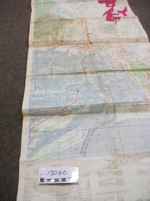
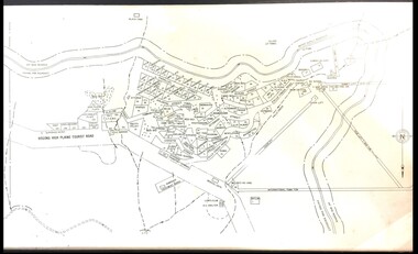 Falls Creek Historical Society
Map - Falls Creek mid 1970s
A site map produced for the Falls Creek Tourist Area Management CommitteeThis map is significant because it documents an important stage in the development of Falls Creek, Victoria.A framed and mounted site map of Falls Creek mid 1970sfalls creek tourist area management committee, falls creek tourist area, falls creek 1970s -
Stawell Historical Society Inc
Archive, Cemetery Trust Stawell. Receipts and Expenditure
Green Coverstawell, cemetery -
Ringwood and District Historical Society
Legal record - Conditions of Sale (C.E.Carter), Ringwood - Lots 22 & 23, Plan of Subdivision No 7112, M Williams to F W Taylor - 1927
Particulars and Conditions of Sale of Property , from Matilda Williams to Frank William Taylor -
Moorabbin Air Museum
Archive (Item) - Box Baa 76 Boeing (Gaf / Asta) Collection
Description: - JINDIVIK DRAWINGS B3A-88-01 TO B3A-88-108 Level of Importance: National. Historical Details: DAP/GAF/ASTA constructed many overseas designs under licence in Australia (Beaufort, Beaufighter, Lincoln, Canberra and F18) however they also designed and constructed a number of significant local designs that were successful in oversea's markets includi -
Ringwood and District Historical Society
Legal record - Conditions of Sale (C.E.Carter), Box Hill - Lots 110, 111, 112 & part of Lot 113, Plan of Subdivision No 1879, National Trustees Executors & Agency Company of Australasia Limited ( Executor of Estate of R.E.Ward) to Unstated Purchaser, 1931
Particulars and Conditions of Sale of Property , from Estate of R.E.Ward to Unstated -
Bendigo Historical Society Inc.
Map - SANDHURST, SHEET ?, Date missing
Map: Sandhurst (sheet No., Missing) P_arish planmap, bendigo, parish plan, sandhurst -
Moorabbin Air Museum
Archive (Item) - Box Baa 102 Boeing (Gaf / Asta) Collection
Description: Drawing Pack AWADI Pulley Miscellaneous Jindivik Correspondence between Australia & UK - Jindivik Correspondence File 17/06/1987 to 05/06/1991 425-1-1 to 425-2-4 Jindivik Correspondence File 30/04/1991 to 23/08/1991 425-2-5 to 425-4-1 Level of Importance: National. Historical Details: DAP/GAF/ASTA constructed many overseas designs under licence in Australia (Beaufort, Beaufighter, Lincoln, Canberra and F18) however they also designed and constructed a number of significant local designs that were successful in oversea's markets includiCAC -
Bendigo Historical Society Inc.
Map - YALLOOK : COUNTY OF BENDIGO, 1957
Map. Yallook, County of Bendigo,Talambe, Tandarra, Neilborough, Yarraberb, Salisbury, Pompapiel. Drawn and reproduced at the Department of Lands and Survey, Melbourne.1957. Price 2/-. By authority W.M. Houston, Government Printer. (number 11 in map cupboard 1)W.M Houston, Government Printermap, bendigo, yallook -
Bendigo Historical Society Inc.
Map - SANDHURST (PART), Circa 1900
Map: Sandhurst ( part), sheet No., Missingmap, bendigo, parish plan, sandhurst -
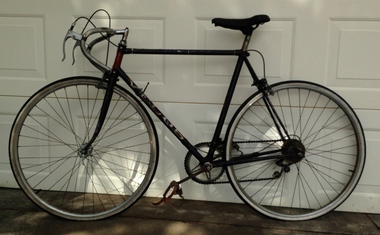 Geelong Cycling Club
Archive - Track Bike, 1949
Track cycle built by Eugene Cowley in 1949 for Ken Jenkin from the Geelong Amateur Cycling Club.Gene Cowley began building cycles in the 1890s and continued until the middle 1950s. He was the first president of the Geelong Amateur Cycling Club.Velos Track and Road Cycle. It has a steel frame, steel rims, rubber tyres, Brookes saddle, pedals with toe straps, handle bars for track racing and dual brakes. This machine is equipped with an early derailler gear- note change lever on down tube. The frame is painted grey and has a Velos badge on the seat stem and a V in white with a red background on the head stem. The word Velos is also outlined on the frame in white with red shadowing."Velos/V"ken jenkin; eugene cowley; geelong amateur cycling club; track cycle; velos track and road cycle; brookes saddle; geelong cycling club; -
Moorabbin Air Museum
Archive (Item) - Box Baa 70 Boeing (Gaf / Asta) Collection
Description: - JINDIVIK DRAWINGS B2-40-90 TO B2-85-147 Level of Importance: National. Historical Details: DAP/GAF/ASTA constructed many overseas designs under licence in Australia (Beaufort, Beaufighter, Lincoln, Canberra and F18) however they also designed and constructed a number of significant local designs that were successful in oversea's markets includi -
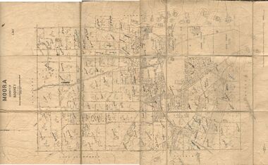 Bendigo Historical Society Inc.
Map - JACK FLYNN COLLECTION: MOORA, 9/10/22
Map: Parish of Moora, County of Rodney. Parish plan.By Authority A.J. Mullet Government Printer Melbourne. Photo Lithographed at the Dept, of Lands and Survey, Melbourne by W.J. Butson. 3.10.22map, rodney, parish plan, moora -
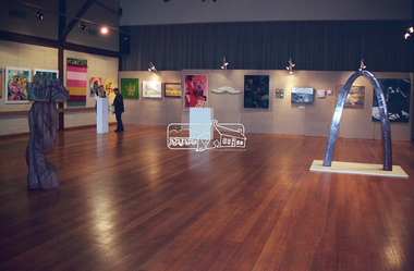 Eltham District Historical Society Inc
Negative - Photograph, Art show, Eltham Community Centre, c.1994
Art show held in the Eltham Community CentreRoll of 35mm colour negative film, 1 stripKodak Gold 100-4art exhibition, eltham community centre -
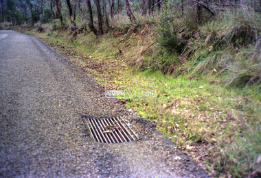 Eltham District Historical Society Inc
Negative - Photograph, Eltham Shire Council, Unidentified road, Eltham district, c.1985
One of a series of images on roll of film shot by Eltham Shire Council officers focussing on road and street infrastructure maintenance and upgrades and new rollover kerb and channel profilesRoll of 35mm colour negative film, 5 stripsKodak CP100 5094infrastructure, road construction, road drainage, road sealing, roadworks, shire of eltham, streets, streetscape -
Bendigo Historical Society Inc.
Map - PARISH OF MARONG ALLOTMENTS, No date Visible
Map: Parish of Marong Allotments, County of Bendigo. Parish plan Blueprint (number 286 in map cupboard 1)map, bendigo, allotments, marong allotments -
Canterbury History Group
Map - Canterbury Subdivisions
A collection of 6 maps with notations showing the names and dates of land subdivision in Canterbury and surrounding suburbs.canterbury, logans estate, shrublands estate, claremount park estate, arklow hill estate, griffin estate, monomeath estate, mont albert park estate, great railway estate, grange estate -
 National Vietnam Veterans Museum (NVVM)
Map, XA BINH BA (SE), 1967
Paper in map in strip form of Vietnam highlighting in red specific area of interest luscombe Field Nui Dat Overprint Information from RA SVY and Intelligence Sources Nov 67map, vietnam, ra svy -
 Eltham District Historical Society Inc
Negative - Photograph, No. 1 Creek, Kinglake, c.1916
This photo forms part of a collection of photographs gathered by the Shire of Eltham for their centenary project book,"Pioneers and Painters: 100 years of the Shire of Eltham" by Alan Marshall (1971). The collection of over 500 images is held in partnership between Eltham District Historical Society and Yarra Plenty Regional Library (Eltham Library) and is now formally known as the 'The Shire of Eltham Pioneers Photograph Collection.' It is significant in being the first community sourced collection representing the places and people of the Shire's first one hundred years.Digital image 4 x 5 inch B&W Negshire of eltham pioneers photograph collection, kinglake, kinglake national park, no. 1 creek -
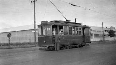 Ballarat Tramway Museum
Negative, Wal Jack, early 1950's
Negative and Digital images of the Wal Jack Ballarat Negative file of Geelong 32 in Aberdeen St, just after turning from Pakington St. The tram has the destination of North. In the background is a shop advertising Spartan paints. Photo early 1950's.trams, tramways, geelong, pakington st, aberdeen st, beach, tram 32 -
 Bendigo Historical Society Inc.
Map - FORTUNA HUSTLER'S MINE - LONGITUDINAL SECTION OF THE FORTUNA HUSTLER'S MINE
Longitudinal Section of the Fortuna Hustler's Mine on the Hustler's Line of Reef, Bendigo. Bulletin No 33, Plate No IV. Shows poppet legs at the surface level, Datum Line 750 feet above Sea Level, levels and their depths, the amount of gold per ton and some geographical features. Geological Survey of Victoria emblem and signed by H A Whitelaw, Underground Survey Office, Bendigo. Note - Plates 4, 8, 13, 20, 26 & 31 form a Longitudinal Section from Fortuna Hustler's to Hustler's Consols Mine. This item has not been scanned or photographed.mining, parish map, fortuna hustler's mine, longitudinal section of the fortuna hustler's mine, geological survey of victoria, h a whitelaw, underground survey office bendigo, hustler's line of reef, hustler's consols mine -
Stawell Historical Society Inc
Archive - Plan, Stawell Water Supply, Stawell Water Supply Plan and Section of Valve House, c 1878
Part of Infrastructure on Big Hill For Stawell Water Supply Large Technical drawing of Piping Significant Tears and Sections MissingScale 4 ft to 1 inch -
Bendigo Historical Society Inc.
Map - SURVEY OF MINES, SANDHURST, NEW CHUM, Circa 1881
Map: Survey of Mines, Sandhurst, New Chum, Longtitudinal Section of the New Chum, reef. 2 sheets. Sheet 5 and Sheet 8map, mining plan, survey of mines , sandhurst, new chum, gold mines bendigo -
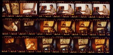 Vision Australia
Negative - Image, Italian Talking Newspaper Service, September 1991
Recording of La Fiamma for the Talking Newspaper Service in Sydney. 10 negatives of coloured images of narrator in studio and 1 printed proof sheetroyal blind society of nsw, talking newspaper service -
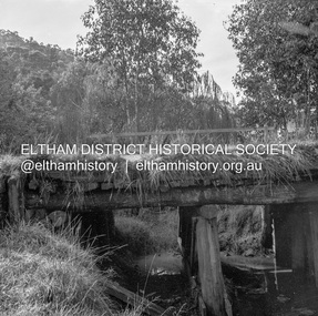 Eltham District Historical Society Inc
Negative - Photograph, J.A. McDonald, Heidelberg-Kinglake Road, 11 May 1961
Yow Yow Creek bridge 11 May 1961Record of various Shire of Eltham infrastructure works undertaken during the period of 1952-1962 involving bridge and road reconstruction projects, sometimes with Eltham Shire Council Project Reference numbers quoted. It was during this period that a number of significant improvements were made to roads and new bridges constructed within the shire that remain in place as of present day (2022). In many situations, the photos provide a tangible visible record of infrastructure that existed throughout the early days of the Shire. The album was put together by or under the direction of the Shire Engineer, J.A. McDonald.1961-05-11, heidelberg-kinglake road, infrastructure, bridge construction, shire of eltham, yow yow creek -
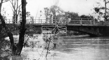 Eltham District Historical Society Inc
Negative - Photograph, Diamond Creek floodwater at Monash Bridge, Hurstbridge, Dec. 1934
The historic 1934 flood of the Diamond Creek and Yarra River following the storms of 29-30 November set the levels for future planning with respect to flood water rise.This photo forms part of a collection of photographs gathered by the Shire of Eltham for their centenary project book,"Pioneers and Painters: 100 years of the Shire of Eltham" by Alan Marshall (1971). The collection of over 500 images is held in partnership between Eltham District Historical Society and Yarra Plenty Regional Library (Eltham Library) and is now formally known as the 'The Shire of Eltham Pioneers Photograph Collection.' It is significant in being the first community sourced collection representing the places and people of the Shire's first one hundred years.Digital image 4 x 5 inch B&W Negshire of eltham pioneers photograph collection, hurstbridge, 1934 flood, floods, monash bridge, diamond creek (creek) -
Kew Historical Society Inc
Archive (Sub-series) - Subject File, Depression, 1930s, 1958
Various partiesReference, Research, InformationSecondary Values (KHS Imposed Order)Subject file containing a anonymous, undated article (single page) on the Great Depression in Kew. It might be from Vaughan’s history (1960). It covers Council support and the creation of the Yarra Boulevardgreat depression -- kew (vic.), kew -- history -- 1930s, yarra boulevardgreat depression -- kew (vic.), kew -- history -- 1930s, yarra boulevard -
Bendigo Historical Society Inc.
Map - CAMPBELL COLLECTION: BENDIGO AND DISTRICT MAPS, 6-4-28
Map. Sedgwick, Parishes of Strathfieldsaye, Lyell, and Sedgwick. Scale 20 chains to 1 inch. Total area 5372 acres. Prepared in W.P.B. from C.L.and A. Plans by W.J.Galbraith 6-4-28. (number 400 in map cupboard 1)W.J.Galbraith.map, bendigo, agricultural lands -
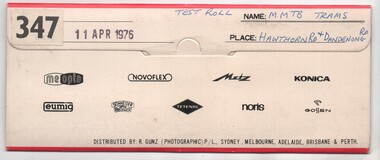 Melbourne Tram Museum
Negative, Bruce Herbert, "MMTB Trams - Hawthorn and Dandenong Road", 11/04/1976 12:00:00 AM
Negative folder - made by SAGA Japan, containing 8 no. 120 film negatives 60mm x 90mm of MMTB Trams at the intersection of Hawthorn and Dandenong Road 11 April 1976, marked "Test Film" and stamped "347". .1 - Harris Train at ? .2 - 901 - route 64, City .3 - 959 - route 69 - Kew Cotham Road - with a CP Air advert .4 - Tramway Emergency Vehicle .5 - 947 - route 64 Three negs not scanned.trams, tramways, sw6 class, dandenong rd, hawthorn rd, route 64, route 69, r10 vehicle, railways, tram 901, tram 959, tram 947, aec, mmtb -
Bendigo Historical Society Inc.
Archive - MCCOLL, RANKIN AND STANISTREET COLLECTION: NORTH DEBORAH GMC N L - MINE BOX, 1940's
Mining box. Metal box, painted dark blue, formerly box number 474 - Now North Deborah Mining Box 19. Tag affixed to front 'box 474'. North Deborah written on brown paper label on the front of the box. Box contains various documents relating to the North Deborah Mine. Documents are individually catalogued within box.North Deborah on labelmining, business, north deborah mining box 19, mccoll, rankin & stanistreet, north deborah gmc n l, gold mining, mining box