-
 Federation University Historical Collection
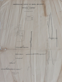
Plan, Underground Survey of Mines, Ballaarat, Britannia Company, not dated
Printed underground survey of the Britannia Companyunderground survey, britannia company, last chance company, transverse section -
 Stawell Historical Society Inc
Archive, Stawell Agricultural Society – Minutes 1909 - 1929, 1909 - 1929
Large Book Green Mottled Cover Maroon Spine and cornersMinute Bookstawell -
Bendigo Historical Society Inc.
Map - TOOLLEEN ALLOTMENTS, circa 1870
Map: Parish plan showing Village allotments at Toolleen, Parish of Toolleen, County of Rodneymap, rodney, toolleen, parish of toolleen, county of rodney -
Kew Historical Society Inc
Archive (series) - Subject File, ANDERSON, Harold H (1897-1956), 2005
Australian Family Tree ConnectionsReference, Research, InformationKHS Imposed OrderSubject file containing a 2-page article, published in Australian Family Tree Connections (November 2005). The article describes Harold and his brother Sydney’s military experiences in the First World War. The article includes an image of Harold’s Town of Kew Roll of Honor certificate. It notes that he is listed on the Kew War Memorial. harold h anderson, first world war - kewharold h anderson, first world war - kew -
Moorabbin Air Museum
Archive (Item) - Box Baa 114 Boeing (Gaf / Asta) Collection
Description: GAF - GAF/B3B/1 Book 1 - Jindivik Mk 203B General and Technical Info 1970 BAE - BT14134 Issue 1 - Flight Limitations and Recommendation for Jindivik Mk 103B Target Aircraft - 700 Series July 1984 GEC Avionics (UK) - ASTA System Manual 256TP Level of Importance: National. Historical Details: DAP/GAF/ASTA constructed many overseas designs under licence in Australia (Beaufort, Beaufighter, Lincoln, Canberra and F18) however they also designed and constructed a number of significant local designs that were successful in oversea's markets includi -
Kew Historical Society Inc
Archive (Sub-series) - Subject File, Farming (Kew), 1958
Various partiesReference, Research, InformationSecondary Values (KHS Imposed Order)Subject file containing a newspaper article/clipping called ‘Our Pastoral Routes’ by Jenny Brown.kew (vic) - history, kew (vic) - farming, kew (vic) - dairies, kew (vic) - agriculturekew (vic) - history, kew (vic) - farming, kew (vic) - dairies, kew (vic) - agriculture -
Bendigo Historical Society Inc.
Map - PARISH OF HUNTLY(PART) AND SANDHURST(PART), No date visible
Map: Part of parish plan of Bendigo, covering Strathdale, White Hills, Huntly and North Bendigo ( number 144 in Map Cupboard 1)map, bendigo, city streets, parish of hunlty, parish of sandhurst, strathdale, white hills, huntly, north bendigo -
University of Melbourne, Burnley Campus Archives
Plan (Item) - Coloured plan, laminated, Sewerage & Water Plan
-
 Kew Historical Society Inc
Plan, Melbourne & Metropolitan Board of Works : Borough of Kew : Detail Plan No.1590, 1905
The Melbourne and Metropolitan Board of Works (MMBW) plans were produced from the 1890s to the 1950s. They were crucial to the design and development of Melbourne's sewerage and drainage system. The plans, at a scale of 40 feet to 1 inch (1:480), provide a detailed historical record of Melbourne streetscapes and environmental features. Each plan covers one or two street blocks (roughly six streets), showing details of buildings, including garden layouts and ownership boundaries, and features such as laneways, drains, bridges, parks, municipal boundaries and other prominent landmarks as they existed at the time each plan was produced. (Source: State Library of Victoria)This plan forms part of a large group of MMBW plans and maps that was donated to the Society by the Mr Poulter, City Engineer of the City of Kew in 1989. Within this collection, thirty-five hand-coloured plans, backed with linen, are of statewide significance as they include annotations that provide details of construction materials used in buildings in the first decade of the 20th century as well as additional information about land ownership and usage. The copies in the Public Record Office Victoria and the State Library of Victoria are monochrome versions which do not denote building materials so that the maps in this collection are invaluable and unique tools for researchers and heritage consultants. A number of the plans are not held in the collection of the State Library of Victoria so they have the additional attribute of rarity.Original survey plan, issued by the MMBW to a contractor with responsibility for constructing sewers in the area identified on the plan within the Borough of Kew. The plan was at some stage hand-coloured, possibly by the contractor, but more likely by officers working in the Engineering Department of the Borough and later Town, then City of Kew. The hand-coloured sections of buildings on the plan were used to denote masonry or brick constructions (pink), weatherboard constructions (yellow), and public buildings (grey). Surveyed by the Board of Works in 1903 and published in 1904, Plan No.1590 shows development north of Cotham Road. While this plan includes built structures in Mary Street, Cotham Road, High Street, Park Hill Road, Kent Street, Ridgeway Avenue, and Ermington Lane (now Ermington Place), only part of this section was notated and coloured in this contractor’s copy. Numerous houses, large and small are named on the plan: ‘Cholula’, ‘Belper’, ‘The Uplands’, ‘Spring Grove’ facing Cotham Road; ‘Marion’ facing Kent Street; and ‘Kia Ora’ facing Ridgeway Avenue.melbourne and metropolitan board of works, detail plans, mmbw 1590, survey plans - borough of kew, cartography -
Kew Historical Society Inc
Archive (Sub-series) - Subject File, BON, Ann (1838-1936), 1958
Various PartiesReference, Research, InformationKHS OrderSubject file containing information about Ann Bon (1838-1936) who for a period lived in Charles Street and is buried in the Boroondara General Cemetery. The file includes correspondence, printed articles, and typed secondary sources. ann bon, william barakann bon, william barak -
Bendigo Historical Society Inc.
Map - BENDIGO, GREATER CITY OF, 2013
Map, City of Greater Bendigo, Epsom/Huntly, Heathcote, Strathfieldsaye/ Junortoun, Mandurang, Sebastian, Mia Mia, Maiden Gully, Ravenswoon, Axedale, Myers Flat, Redesdale, September 2013, on front. Lockwood South, Marong, Raywood, Neilborough, Elmore, Goornong, on reverse side. ( number 413 in Map Cupboard 1 ). Donated by Bendigo Council.bendigo, hospital -
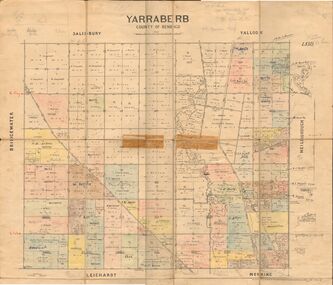 Bendigo Historical Society Inc.
Map - JACK FLYNN COLLECTION: YARRABERB, 2/03/1931
Map: Yarraberb, County of Bendigo. Parish plan.By Authority H.J. Green Govt., Printer. Photo Lithographed at the Department of lands and Survey Melbourne, 2.3.31.map, bendigo, parish plan, yarraberb -
Bendigo Historical Society Inc.
Map - TOWN OF INGLEWOOD, March 1946
Map: Town of Inglewood, Parish of Inglewood, County of Gladstone. Parish planmap, gladstone, township, inglewood -
Bendigo Historical Society Inc.
Map - NEW CHUM LINE, 1875
Plan: Longtitudinal section of the Southern Section of the New Chum Line of Reef. Compilation consisting of small sections stapled togetherCALEB THOMAS 1875map, mining plan, gold mines, new chum line -
Moorabbin Air Museum
Archive (Item) - Box Baa 66 Boeing (Gaf / Asta) Collection
Description: - JINDIVIK DRAWINGS B2-20-12/13 TO B2-20-77 Level of Importance: National. Historical Details: DAP/GAF/ASTA constructed many overseas designs under licence in Australia (Beaufort, Beaufighter, Lincoln, Canberra and F18) however they also designed and constructed a number of significant local designs that were successful in oversea's markets includi -
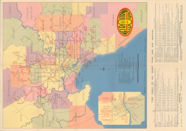 Melbourne Tram Museum
Map, Melbourne & Metropolitan Tramways Board (MMTB), "Map and timetable of Melbourne Tram and Bus Services" - March 1952", Mar. 1952
Fold out map (10 sections), coloured of Melbourne's Tram and Bus routes, route numbers, rail lines, municipalities boundaries and location of major places of interest. Titled - "Map and timetable of Melbourne Tram and Bus Services" - May 1952". At base of map - timetable of all night trams and bus services. On rear index to routes, 1st and last services, time of Sunday am services, Latrobe St. services and photo of Wattle Park. Dated March 1952 - Bourke St shown as bus. See Reg Item 413 for the May 1956 version. Very high resolution scans held. See also Reg Item 3720 for a MMTB Map of the same era.trams, tramways, melbourne, map, tram & bus services, all night services, mmtb -
Bendigo Historical Society Inc.
Map - BENDIGO (COUNTY), Circa 1870's
Map:Plan showing the whole of the County of Bendigo-- attached handwritten sheet in the top left hand corner-'Proclaimed Commons Sandhurst District'. Also attached is a separate plan of the parish of Kimbolton (number 262 in map cupboard 1)map, bendigo, parish plan, bendigo, proclaimed commons -
Surrey Hills Historical Society Collection
Archive - Vertical file, City of Camberwell
A vertical file of clippings and general information relating to the City of Camberwell including: 1. Election notice, The Argus, 28.8.1937 (1 page). 2. “City news”: Council announces conservation position. Undated. (8 pages). 3. “Council to introduce new waste collection”. Undated Council publication. (4 pages). 4. Camberwell newsletter (incomplete, undated). (4 pages). 5. Camberwell City News, December 1983. (8 pages). 6. Camberwell City News, October, 1984. (8 pages). 7. City of Camberwell 1984/5 budget. (8 pages). 8. ‘’Recycling – It’s up to you’’ (source uncertain, like Council publication undated). (1 page). 9. ‘’Big bins arrive’’, Free Press, 1.2.1984. (1 page). 10. New bins photo and article – no heading; Free Press, 11 April 1884 with note re role of Cr Jim Rumpf. city of camberwell, cr jim rumpf, waste collection, recycling, local government -
Port Melbourne Historical & Preservation Society
Archive - Transcripts of interviews, 1990 - 1991
File 04 - Written transcripts of interviews and/or noteslocal government - city of port melbourne, built environment, families, celebrations fetes and exhibitions, domestic life, industry, recreation, sport, pat grainger, jill dawson, wendy morris, vintage port - worth preserving project 1991 -
 Federation University Historical Collection
Plan, Ballarat Goldfields Geological Survey, 1981
Large coloured plan showing streets, leads, geological zones and shafts. Source 1:10,000ballarat, gold, goldfield, geology, sebastopol -
Port Melbourne Historical & Preservation Society
Plan - Conceptual Perspective Drawings, Port Melbourne Yacht Club, Taylor Howden Pty Ltd, Architects, 1990s
Port Melbourne Yacht Club .01 - 02 Clubhouse reconstruction conceptual perspective drawings sport - yachting, built environment - recreational facilities -
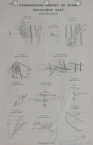 Federation University Historical Collection
Plan, Underground Survey of Mines, Ballaarat East Sections, c1890
Printed plan showing cross sections of various mine shaftsplan, underground survey, ballaarat east, mining -
Port Melbourne Historical & Preservation Society
Plan - Proposed Alterations, Port Melbourne Town Hall, B S Elms & Co Pty Ltd, 23 Jun 1966
From a set of two drawings, 1966 - plans - details of alterations to Council Chamber, Councillors Room and first floor of Town Hall - not proceeded with. port melbourne town hall -
Stawell Historical Society Inc
Archive, Prince Edwards Letter To Australian School Children 1920, 1920
Print of Hand Written letter to All Australian Childrenstawell, education -
Stawell Historical Society Inc
Archive, Cemetery Trust Stawell. Non Purchases of Land
stawell, cemetery -
Stawell Historical Society Inc
Map - Subdivision map, Subdivision of Woodlands Estate Map
Shows Homestead Cottage and Dam, Plus Shed. Malakoff NavarreA3 photocopy of MapParishes of Malakoff and Navarre. County of Kara karasurvey -
Bendigo Historical Society Inc.
Map - UNITED HUSTLER'S & REDAN MINE - TRANSVERSE SECTION UNITED HUSTLER'S & REDAN MINE
Transverse Section of the United Hustler's & Redan Mine on the Hustler's Line of Reefs Bulletin No 33, Plate No XXIX. Map has drawing of poppet legs on the surface, depth of levels, type of stone encountered and some geological features. Sill of shaft 745.62 ft above sea level. Map has Geological Survey of Victoria emblem and signed by H S Whitelaw, Underground Survey Office Bendigo, 'September 1913. This item has not been scanned or photographed.mining, parish map, united hustler's & redan mine, hustler's line of reef, geological survey of victoria, h s whitelaw -
Kew Historical Society Inc
Archive (Sub-series) - Subject File, Kew Historical Society, Kew Association, 1974
Various partiesReference, Research, InformationSecondary valuesSubject file on ‘The Kew Association’ formed in 1974 as a separate group to the Kew Historical Society. Its constitution, which is filed, is general in nature. One part of the Association’s interests was the formation of a Historical Working Group to ‘examine historic buildings and other aspects of Kew’s history’. A founding member of the Society, Joy Stewart, was its convenor. By June 1974 it had 133 members. It differed from the Society in that it specifically aimed to improve Council services. One of its achievements was to begin a ‘historical home survey’ by street. The survey documents in the file list street name, number of house, side of street, size of house and general observations. Other information in the archive file includes correspondence, agendas, minutes etc. of the Association. As these only cover the years 1974-5, this may have been the period in which the group operated.kew - history, kew association - kew (vic), community groups - kew (vic), heritage - kew (vic)kew - history, kew association - kew (vic), community groups - kew (vic), heritage - kew (vic) -
Stawell Historical Society Inc
Archive, Share Register. Call & Transfer Book, Oct 1873 - Feb 1876
Large Book with heavy card coverShare Register Call & Transfer Bookstawell -
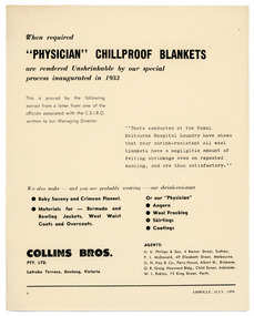 National Wool Museum
Archive - “Physician” Chillproof Blankets, Collins Bros Mill Pty Ltd, July 1959
Single page black and white leaflet with printed text. front: [printed] When required / “PHYSICIAN” CHILLPROOF BLANKETS / are rendered Unshrinkable by our special / process inaugurated in 1933products, blankets, collins bros mill pty ltd, physician, advertising