-
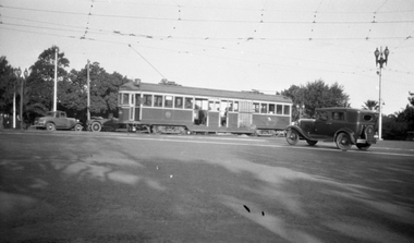
 Melbourne Tram Museum
Negative, Wal Jack collection, mid 1920's
Black and White Copy Photograph of Birney X class 217 at the Malvern Depot. Mid 1920'strams, tramways, x class, birney, malvern depot, tram 217 -
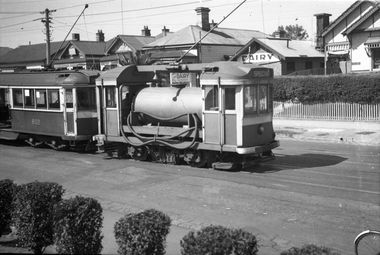 Melbourne Tram Museum
Negative, Wal Jack, 15/03/1945 12:00:00 AM
Black and white negative, by Wal Jack, of Scrubber 8 and W5 802 in Maribyrnong Road. Wal's album notes that the photo is at the River terminus and dated 15-3-1945. In the background is the Lily Dairy.trams, tramways, maribyrnong rd, scrubber tram, work trams, w5 class, tram 8, tram 805 -
 Ringwood and District Historical Society
Archive - Parent Record, Ringwood Croquet Club - Archive Collection (Parent Record)
Parent Record for Archive collection of photographs and documents relating to Ringwood Croquet Club -
 Eltham District Historical Society Inc
Negative - Photograph, Intersection of Mt Pleasant Road at Main Road, Eltham, c.Dec. 1983
Reconstruction work was planned for Main Road to install a roundabout at Mount Pleasant Road. Traffic to Lower Plenty and Templestowe to be diverted down Bridge Street (and Bolton Street) effective January 1984. The proposed roundabout did not proceed. Instead traffic islands on Mount Pleasant Road were installed in place of temporary blocked out islands and revised extended driveway to properties 622-642 Main Road with access off Mount Pleasant Road instead.Film - Kodak CM 400 5079 7 strips, 26 framesinfrastructure, roads, road construction, roundabout, road sign, main road, mount pleasant road, eltham -
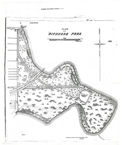 University of Melbourne, Burnley Campus Archives
Plan - Photocopy, A.L. Martin et al, Plan of Richmond Park, 1872
Layout of Richmond Park showing railway line, Pic-Nic Station, Swan Street extension and Horticultural Society's Garden. 3 photocopies of plan surveyed and drawn by A.L. Martin, Authorised Surveyor. Photolithographed at Dept of Lands and Survey by J. Noone 6th Sept. 1872. Showing the entire park and the Horticultural Society's Garden.richmond, parks, a.l. martin -
 Melbourne Tram Museum
Negative, Wal Jack collection, c1930
Black and white negative from Wal Jack collection of W2 255 or 355 in St Kilda Road Melbourne at junction with City Road, with route number 7 showing. Photo c1930. Photo may not be by Wal Jack as a size that he did not use.trams, tramways, st kilda road, city road, route 7, w2 class, tram 255?, tram 355? -
 Melbourne Tram Museum
Negative, Wal Jack collection, c1950
Black and white negative, of W2 528 along with other trams in Brunswick depot, c1950. Tram has the destination showing of South Melbourne beach and route 1 and has an maxillary board advertising the Red Cross Market Fair. Photo not in Wal Jack Melbourne album.trams, tramways, w2 class, brunswick depot, tram 528 -
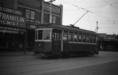 Melbourne Tram Museum
Negative, Wal Jack, late 1930's?
Black and white negative, by Wal Jack, of X1 460, at the Footscray Railway Station terminus in Leeds St. Has the destination of Russell St. Tram has a Pay as You leave sign. In the background is the Franklin Chemist, Appleton and Wright Menswear, Roy Thomas Tailor, and R. S. Smith Printer. Either late 1930's, 1940 or post 1945 no white stripe on tram.trams, tramways, footscray, leeds st, x1 class, tram 460 -
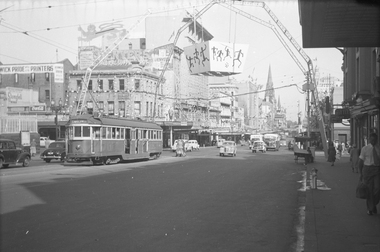 Melbourne Tram Museum
Negative, Wal Jack, 10/03/1954 12:00:00 AM
Black and white negative, by Wal Jack, of W2 625 northbound in Swanston St at Lonsdale St. Extensive flagging bunting and an arch with an aboriginal motifs suspended by an arch structure over the intersection. The bus on the south west corner is a Reo Bullnose type. Bruce Eames on Facebook advised 7/9/2020; it’s been identified as the 1954 Royal Visit - https://viewer.slv.vic.gov.au/?entity=IE5664991&mode=browse Paul Kennelly of BCSV advised - 14/5/2023 - The bus in Swanston Street is a Giles bodied Reo that was new in 1947 to Lew Page, either JB 652 (on Route 1) or JJ 337 (on Route 2). Both became part of Melbourne-Brighton Bus Lines upon amalgamation of the multiple operators of both routes in July 1954.trams, tramways, swanston st, lonsdale st, events, w2 class, buses, royal visit, tram 625 -
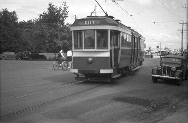 Ballarat Tramway Museum
Negative, Wal Jack, late 1945
Yields information about the appearance of the ex Melbourne bogie trams during the initial period of operations in Ballarat.Negative and Digital image of the Wal Jack Ballarat Negative file of bogie car, most likely ex Melbourne 117, future 22 at the intersection of Wendouree Parade, Ripon and Webster Streets. Tram has the destination of city. Late 1945. It would appear that the sides of the tram have been painted but not the rear end, still has the MMTB War time markings on the tram. trams, tramways, wendouree parade, new trams, webster st, ripon st, bogie trams, tram 22 tram 117 -
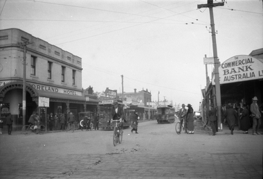 Melbourne Tram Museum
Negative, Ellis Collection, c1956
Negative (120) of the intersection of Moreland Road and Sydney Road, Brunswick, during the 1920's. In the view is a cable tram set shunting. A tramway employee and two boys at the front of the grip car seem to be manipulating something. Saloon car is No. 183 with the conductor pushing the car. The grip car has the destination of Brunswick and the saloon Flinders St? Note the two steel tramway poles and overhead for the North Coburg electric tram service from Moreland Rod into Sydney Road. In the background is the Moreland Hotel, Clarkson chemist and the Commercial Bank of Australia. An low resolution A4 laminated was received with the negatives. Hi Res image filed in the dbtext/hawthtramcoll/Large Images/htd3589large.jpgtrams, tramways, brunswick, cable trams, sydney rd, moreland rd, tram 183 -
Glenelg Shire Council Cultural Collection
Plan - Ship Plan / Mould, n.d
Wooden pattern for moulds for boat fittings. Flat, 'dagger' shape, round top, with round hole, pointed end, front painted brown, back white. -
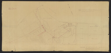 University of Melbourne, Burnley Campus Archives
Plan, School of Horticulture -Burnley, 1950
Same layout as plan at B91.0471, but showing PMG cables, and buildings existing, proposed and temporary or for demolitionPlan showing layout of PMG cables and PMG plant. Area bounded by Swan St., Yarra Boulevard, orchard, vegetable garden, market garden and S.W. Boundary to Stockman's Cottage. PMG layout handwritten. On same plan as B91.0484 (original) and B11.0383.burnley school of horticulture, orchard, gardens, vegetables, stockman's cottage -
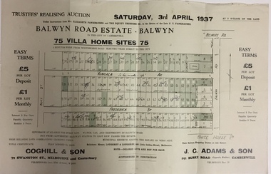 Kew Historical Society Inc
Plan - Subdivision Plan, Balwyn Road Estate, Balwyn (1937), 1937
Historic subdivision in Balwyn, VictoriaSubdivision Plan of Balwyn Road Estate (Balwyn). Held in April 1937, the auction included 102 lots for sale in Yongala Avenue, Young Street, and Balwyn RoadInscriptions on individual lots by agentsubdivision plans - balwyn (vic), balwyn road estate - balwyn -
Moorabbin Air Museum
Plan (Item) - CAC Plans - Switches, Switch Plans
Commonwealth Aircraft Corporation -
 Federation University Historical Collection
Plan, Blueprint
-
Stawell Historical Society Inc
Archive, Callawadda Progress Association. Expenditure Receipts 1915 – 139, 1915 - 1939
stawell -
Kew Historical Society Inc
Archive (series) - Subject File, MCINTOSH, Andrew
Kew Historical SocietySince its foundation in 1958, members of the Kew Historical Society have been compiling and storing information about subjects relating to the history of Kew and its environs, of which this file is an example. Arranged by Secondary Values (value of records to users)Subject file created by researchers of the Kew Historical Society containing newspaper articles and letters to the editor about Andrew McIntosh, State Member of Parliament for Kew. This details general background about the electorate and about the reasons why Andrew McIntosh resigned from the Ministryandrew mcintosh, kew. electorate, members of parliament -- victoriaandrew mcintosh, kew. electorate, members of parliament -- victoria -
Glenelg Shire Council Cultural Collection
Financial record - Passbook - State Savings Bank of Victoria, Portland Free Library, 1919-1921
State Savings Bank of Victoria pass book issued to Portland Free Library. First entry 25 November 1919, final entry 9 April 1921. Light blue (faded) card cover, royal blue print and bindingFront: purple stamp 'Cancelled carried forward to new passbook' 2 purple stamps 'PFL & LI' Back: 2 of each of the above stampsportland free library, savings, administration, glenelg shire council archives -
Glenelg Shire Council Cultural Collection
Plan - Plans / Line Drawings - Port of Portland Authority Slipway, Bilge Blocks Steel Fishing Vessel, Victoria, 26/08/1987
Port of Portland AuthorityFront: '44' - black texta, top right corner -
Kew Historical Society Inc
Plan - Camberwell Panorama Estate, 1923
Subdivision plans and real estate flyers/brochures reveal a number of aspects of urban development and history. The Kew Historical Society's collection of these plans, as well as advertisements extracted from magazines, cover key aspects of community development and architectural history of Kew and Kew Eat as well as surrounding suburbs. While most of the plans in the collection were gifted to the Society by the former City of Kew, a number of other plans and advertisements have been donated by individuals, of which this is an example.Promotional brochure for the Camberwell Panorama Estate. The four page bifold handout advertises 216 home sites bounded by Bulleen Road, The Nook, Fortuna Avenue, and Doncaster Road. Other streets in the subdivision include: Sunburst Avenue, The Moor, and Macedon Avenue. The brochure has been damaged at some time in the past and so masking tape obscures the tram on page 1. Page 2 includes the plan of the subdivision, page 3 information about the site and a locality plan, while page 4 includes photographs and terms of sale. subdivision plans -- balwyn north (vic.), camberwell panorama estate -
 Eltham District Historical Society Inc
Negative - Photograph, Harry Gilham, Demolition of Eltham Shire Offices, 895 Main Road, Eltham, Aug. 1996
The Shire Offices opened in 1965 and were extended in 1971. The final Eltham Shire Council meeting was held in December 1994 before the forced amalgamations of municipal councils by the Kennett Government. The State-Government-appointed Commissioners (1994-1996) took the decision in July 1996 to demolish the Eltham Shire Offices. The demolition works started within 24 hours of the decision being made.Roll of 35mm colour negative film, 5 of 6 strips Associated printKodak Gold 100-5eltham shire office, demolition -
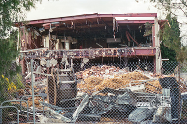
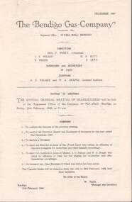 Bendigo Historical Society Inc.
Financial record - Lydia Chancellor collection: Bendigo Gas Company and The Colonial Gas Association Limited
1. The Bendigo Gas Company formed in 1859, established the Bendigo Gas Works and became an incorporated company in 1860. It produced coal gas for the community until it was liquidated and delisted as a company in 1959. 2. The Colonial Gas Association was incorporated in 1888, selling shares for 5pounds and 10 pounds. It was originally formed in London with the aim of raising investment capital for the construction and maintenance of gas works across the cities and towns of Australia and New Zealand. Its original name was the Australasian Gas Association and this changed to the Colonial Gas Association in 1893.The Bendigo Gas Company notice of annual general meeting of shareholders for the years 1947 to 1952. The meeting to be held at the company registered office at 49 Pall Mall, Bendigo. Directors: Rex F. Hyett (Chairman), J.S. Wilson, H.N. Butt, S. Proud, F. Levy. Manager and secretary W. Pain. Also, The Colonial Gas Association Limited notice of annual meeting for the years from 1949 to 1953 to be held at 360 Collins Street, Melbourne. Directors: C.F. Broadhead (Chairman and managing director), James M MacFarlane, Robert Weir, Gerald L. Patterson.bendigo gas comany, the colonial gas association, shareholders -
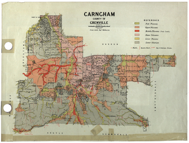 Federation University Historical Collection
Plan, Carngham, County of Grenville
A plan of Carngham, Victoria.snake valley, timber reserve, poverty point, recreation reserve, carngham, county of ripon, county of grenville, plan -
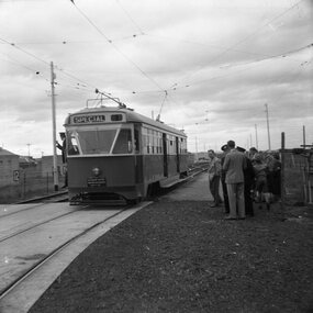 Ballarat Tramway Museum
Negative, Geoff Grant, 8/05/1954 12:00:00 AM
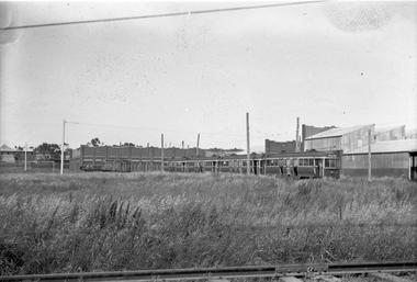
Negative No. 275 and colour print made by colour laser printer (stored in folder ) of Melbourne PCC tram 980, in at the beginning of Footscray branch or connecting line to Footscray, at Munitions factory, during an AETA tour on 8/5/1954. Photo by Geoff Grant. Hi res scan of negative and image updated 19/5/2020.trams, tramways, footscray, pcc, munitions factory, aeta, tram 980 -
Kew Historical Society Inc
Archive (series) - Subject File, Kew Historical Society, JELLIS, Thomas G, 1958
Various partiesReference, Research, InformationSecondary Values (KHS Imposed Order)Subject file containing research and primary sources relating to T.G. Jellis and his family bakery in High Street, and later Studley Park Road, Kew. It includes a 1-page summary compiled by Elizabeth Mackie of an interview with his daughter Mrs Whitney, which was separately recorded on tape. A later document is a reminiscence of the bakery in Studley Park Road by Trevor D. Fiander of Ballan. This document includes drawings of the exterior and interior. [An article on the bakery can also be accessed in KHS Newsletter No.104 September 2013.kew historical society - archives, kew - history, t.g. jellis, mayors of kew - t.g. jellis, bakeries - kew (vic), mrs whitney (1895-?), trevor fianderkew historical society - archives, kew - history, t.g. jellis, mayors of kew - t.g. jellis, bakeries - kew (vic), mrs whitney (1895-?), trevor fiander -
 Kew Historical Society Inc
Plan, Melbourne & Metropolitan Board of Works : Borough of Kew : Detail Plan No.1576, 1904
The Melbourne and Metropolitan Board of Works (MMBW) plans were produced from the 1890s to the 1950s. They were crucial to the design and development of Melbourne's sewerage and drainage system. The plans, at a scale of 40 feet to 1 inch (1:480), provide a detailed historical record of Melbourne streetscapes and environmental features. Each plan covers one or two street blocks (roughly six streets), showing details of buildings, including garden layouts and ownership boundaries, and features such as laneways, drains, bridges, parks, municipal boundaries and other prominent landmarks as they existed at the time each plan was produced. (Source: State Library of Victoria)This plan forms part of a large group of MMBW plans and maps that was donated to the Society by the Mr Poulter, City Engineer of the City of Kew in 1989. Within this collection, thirty-five hand-coloured plans, backed with linen, are of statewide significance as they include annotations that provide details of construction materials used in buildings in the first decade of the 20th century as well as additional information about land ownership and usage. The copies in the Public Record Office Victoria and the State Library of Victoria are monochrome versions which do not denote building materials so that the maps in this collection are invaluable and unique tools for researchers and heritage consultants. A number of the plans are not held in the collection of the State Library of Victoria so they have the additional attribute of rarity.Original survey plan, issued by the MMBW to a contractor with responsibility for constructing sewers in the area identified on the plan within the Borough of Kew. The plan was at some stage hand-coloured, possibly by the contractor, but more likely by officers working in the Engineering Department of the Borough and later Town, then City of Kew. The hand-coloured sections of buildings on the plan were used to denote masonry or brick constructions (pink), weatherboard constructions (yellow), and public buildings (grey). Development in the 20th century has irreparably altered that part of Kew represented in this plan. In the block bounded by Cotham Road, Charles Street, Wellington Street and Gellibrand; just one house standing in 1903 remains. This block included two of the most historic houses in Kew: ‘Ordsall’ (later ‘Southesk’) and ‘Madford’ (previously ‘Elm Lodge’). Ordsall was the home of the second chairman of Kew, John Halfey. It contained some of the most significant interior murals in Kew, created for Halfey by artists working for Cullen & Co. It was demolished in 1960 to make way for the Kew Civic Centre. Elm Lodge had been built for William Siddeley in ca. 1864. Arthur Septimus King purchased it in 1874. The lower paddocks of Madford were sold in 1905 by his wife to the Borough of Kew and, after landscaping by George and Thomas Pockett, opened as the Alexandra Gardens in 1908. Elm Lodge/Madford was in 1922 to become St. Anthony’s Home for Little Children before its subsequent demolition in the 1980s.melbourne and metropolitan board of works, detail plans, maps - borough of kew, mmbw 1576, cartography -
 Federation University Historical Collection
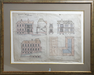
Plan, Balllarat School of MInes New Classrooms, 1899, 1899
Architectural plan for the New Classrooms at the Ballarat School of Mines, later known as the Administration Building.ballarat school of mines, new classrooms, administration building, a building, architectural plans -
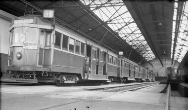
 Melbourne Tram Museum
Negative - Set of 2, Wal Jack, 13/10/1940 12:00:00 AM
Set of two Black and white negatives by Wal Jack of: .1 - C class C28, E43, P136, P134, U211, U209 and No. 11 - dated 13-10-1940. .2 - Photo of the first three cars in the line. The car numbers were detailed in the album held by the Ballarat Tramway Museum. Note the bus body against the brick wall of the workshops and two former grip cars in the view. See Reg Item 5290 for details of the bus body.trams, tramways, preston workshops, u class, c class, n class, e class, p class, stored trams, buses, grip tram, tram 28, tram 43, tram 136, tram 134, tram 211, tram 209, tram 11, mmtb buses -
Port Melbourne Historical & Preservation Society
Plan - Operation geometry of gantry, Inner East, Ferry Terminal, Station Pier, Port Melbourne, Engineering Division, Port of Melbourne Authority, 27 May 1985
Plan - Operation geometry of gantry at Station Pier Inner East Ferry Terminalmelbourne harbor trust - port of melbourne authority