-
 Kadimah Jewish Cultural Centre and National Library
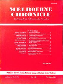
Journal, Kadimah Jewish Cultural Centre and National Library, Melbourner Bleter / Melbourne Chronicle February/March 1983, ADD DATE
Journal published by the Kadimah Jewish Cultural Centre and National Library, Melbourne. Contains essays, reviews, fiction and poetry in both English and Yiddish.60 pages, A4, Softbound, Paper covers. non-fictionJournal published by the Kadimah Jewish Cultural Centre and National Library, Melbourne. Contains essays, reviews, fiction and poetry in both English and Yiddish.moshe ajzenbud, serge lieberman, dr. paul gardner, jean thornton, j.e. shenfield, barrie cohen, gedaliah shaiak, bashevis singer, colin golvan, anne wroby, albert krantz, michael danby, sol encel -
 Bendigo Historical Society Inc.
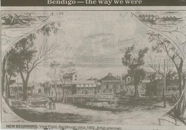
Negative - JENNY FOLEY COLLECTION: NEW BEGINNING
Bendigo Advertiser ''The way we were'' from 2000. New beginning: View Point, Sandhurst; circa 1860. Artist unknown. The clip is in a folder.newspaper, bendigo advertiser, the way we were -
 Moorabbin Air Museum
Journal (Collection) - Collection of Aviation Heritage Quarterlies, ranging from 1983-December 2017, Aviation Heritage: Journal of the Aviation Historical Society of Australia Inc
Aviation Historical Society of AustraliaVolumes 22 to 48 -
 Mission to Seafarers Victoria
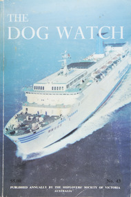
Journal (item) - Periodicals-Annual, Shiplovers' Society of Victoria, The Annual Dog Watch
This journal provides the reader with glimpses of the adventures and hardships of a seaman's life. Many of the stories are of sailing ships.Contributes to our knowledge of the importance of shipping and places on record those stories of the sea which would otherwise be lost.Contents Editorial - - 5 Foreword - Capt.R.J.F. McDonell - 6 Abel Tasman -- The Highway to Tasmania - - 9 Up for Second Mate - E. Moodie-Heddle - 13 The Manifest of the Thistle - - 19 HMAS Shropshire in the Philippines Pt. 2 The Lingayen Landings - F. Hoolahan - 21 Two Shipbuilders - J.B. Thompson - 27 The Diamond Cargo Blues - Captain L. Gibson - 32 Port Victoria Epilogue - W.P. Shemmeld - 33 Letter to the Editor - - 39 Sea Shanties - S. Buckland - 41 Cat Overboard - captain Ron Munro - 45 Voyage in Wongala - Desmond Jackson - 48 Retirement of Tor Lingquist - - 66 The "Lawhill" at Sydney Harbour - - 67 Salvage of the Barque Garthsnaid - Captain L. Gibson - 69 A New Entrance to the Port of Brisbane - - 73 Summer -- North Atlantic - Capt. Fred K. Klebingat - 78 The Days of "Whack" and "Slush" - Sir James Bisset - 89 Olivebank Remembered - Alan Glover - 93 The Hobson's Bay Ferry Boats - Capt. H.R. Watson - 97 The King Island Letter - - 101 As My Memory Serves Me - Gordon Wright - 107 The Yardarmer - R.N. Thiele - 112 Piling Up Memories - F. Wavell Urry - 117 Book Reviews - - 127sailing ships, steamships, shipping, seafaring life, shiplovers' society of victoria, dog watch -
National Vietnam Veterans Museum (NVVM)
Journal, Nui Dat Corner Bulletin
veterans – australia – periodicals -
Stawell Historical Society Inc
Map - Plan, Glenorchy Cemetery, c 1960
Printed map of plots on backing cardScale 1 inch to 12 feetburials -
 Ringwood and District Historical Society
Journal - Documents, Ringwood Croquet Club, Minutes of the Ringwood Croquet Club committee 1980-85
The records of the Ringwood Croquet Club given to Gail Abbe - Archivist for safe - keeping with the request that they may be borrowed should the club require them for reference - 10-Dec-1993.Minutes of the monthly Ringwood Croquet Club committee from 18th March 1980 to 3rd December 1985 -
University of Melbourne, Burnley Campus Archives
Map, Kosciusko Primitive Area, Vegetation & Associated Features, 1972
2 copies of map dated 1972 by Division of Plant Industry, Commonwealth Scientific and Industrial Research Organization. Shows: General Vegetation Approximately 2,000 feet-7,000 feet; and Alpine and Subalpine Complex Approximately 5,000 feet-7,000 feet. Scale 1:31,680.vegetation, mount kosciusko area, alpine vegetation, d.j. wimbush, r.t. morland -
 Melbourne Tram Museum
Map, Morgan Street directory - map of VR Trams, Map - 1940s?
Map - assembled from sheets of the Morgan Street directory for the two VR street tramways from St Kilda to Brighton and from Sandringham Station to Beaumaris or Black Rock. Comprises four sheets taped together and one loose sheet. Tram route marked in green felt pen. Has many adverts on the rear and front for funeral parlours, hotels, real estate agents and the like.trams, tramways, map, vr, sandringham, black rock, beaumaris, brighton, st kilda -
 Peterborough History Group
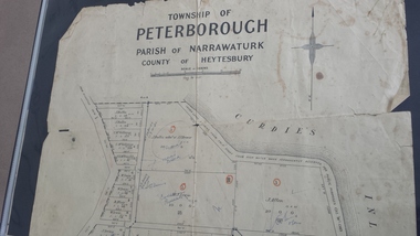
Map - Map of the township of Peterborough, Township of Peterborough
Same map as 4012 but printed names are easier to read. Hand drawn arrows show the road now built connecting Macs St to the Warrnambool RdShows early layout of the town and names of landownersgovernment map of the township of Peterborough with handwritten notes on it. Includes the names of the landowners 1931some hand drawn arrows.peterborough, old maps, maps -
 Bendigo Historical Society Inc.
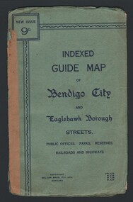
Map - INDEXED GUIDE MAP OF BENDIGO CITY & EAGLEHAWK BOROUGH, Early to mid 1920's
Map. Indexed Guide Map of Bendigo City & Eaglehawk Borough. Folded map contained within blue booklet. Booklet is light blue printed with dark blue ink. Copyright Bolton Bros. Pty. Ltd. Bendigo. Printed on front. Map shows the location of Sailors Gully, Peg Leg Gully, California Gully, Long Gully, Eaglehawk Creek, Bendigo Creek, Ironbark Creek. Shows location of Showgrounds between Park St, Baxter Street, Barnard St and Bridge Lane. Shows location of Golden Square Railway Station between Panton St and Allingham St. Shows what is now known as Creek St. Nth & Sth as Clark St Nth & Sth. Also shows Tramway Terminus along Carpenter St and Golden Square Tram Terminus on High St, Golden Square. Map has a street index and an index for Public Offices, Parks and Reserves.map, bendigo, township, indexed guide map of bendigo city and eaglehawk borough -
 Eltham District Historical Society Inc
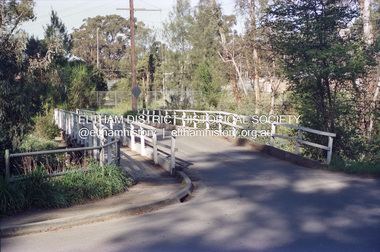
Negative - Photograph, Doug Orford, Diamond Street Bridge, Eltham, 1985
Roll of 35mm colour negative film, 7 stripsFuji 100Neltham, diamond street bridge -
University of Melbourne, Burnley Campus Archives
Journal, The Garden, 2019
gardening -
Glenelg Shire Council Cultural Collection
Negative, c. 1936
Transparency for black and white photo. Portland's Botanic Gardens. Croquet green in foreground, garden beds and trees behind -
Glen Eira Historical Society
Map - Caulfield Fire Station, No 26, Tree Reserve, Dandenong Road
A one page photocopy of an undated, unattributed, hand drawn map (200mm x 290mm) of the location on Tree Reserve, Dandenong Road, of the Caulfield Fire station, No 26. The map includes handwritten notes showing various nearby property owners. The file also includes a photocopy of a one page, undated and unattributed printout of the site address and site lease date.caulfield east, caulfield fire station, dandenong road, derby road, racecourse road, tree reserve, shire of caulfield, federal bank, st james building society, delves murchison, fire stations -
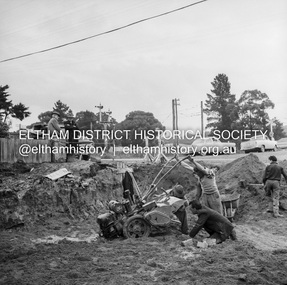
 Eltham District Historical Society Inc
Negative - Photograph, J.A. McDonald, Eltham, Pryor Street, Sep. 1955
Construction of new concrete kerbing and footpath in Pryor Street, Eltham 18” tray and AG backing(?)Record of various Shire of Eltham infrastructure works undertaken during the period of 1952-1962 involving bridge and road reconstruction projects, sometimes with Eltham Shire Council Project Reference numbers quoted. It was during this period that a number of significant improvements were made to roads and new bridges constructed within the shire that remain in place as of present day (2022). In many situations, the photos provide a tangible visible record of infrastructure that existed throughout the early days of the Shire. The album was put together by or under the direction of the Shire Engineer, J.A. McDonald.1955-09, footpaths and gutters, pryor street, infrastructure, shire of eltham -
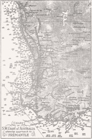 Queenscliffe Maritime Museum
Map - B & W coastal map, Fremantle & SW Coast, Western Australia, Coastal map of SW Coast of Australia & the approach to Fremantle WA, Before donation in 1987
Australian coastal mapsAustralian coastal mapsB&W Coastal map of SW Coast of Australia & the approach to Fremantle WA, from an unknown book, c1864.Reverse " NIL "old maps of australian coast -
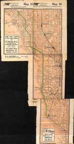
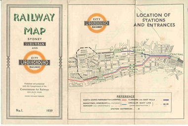 Ballarat Tramway Museum
Map, NSWGR, "Railway Map of Sydney Suburban and Underground" - 1939, 1939
Light card or Heavy paper. Colour map showing location of Sydney stations and entrances and where the trains ran. Issued as No.1. Title "Railway Map of Sydney Suburban and Underground" - 1939. Handle with care - both copies.trams, tramways, sydney, railway map, suburban and underground, trams -
 Eltham District Historical Society Inc
Negative - Photograph, J.A. McDonald, Eltham, Cecil Street, Sep. 1959
Stabilising junction with Eltham-Yarra Glen Road View looking west across Main Road to Diamond Street railway crossingRecord of various Shire of Eltham infrastructure works undertaken during the period of 1952-1962 involving bridge and road reconstruction projects, sometimes with Eltham Shire Council Project Reference numbers quoted. It was during this period that a number of significant improvements were made to roads and new bridges constructed within the shire that remain in place as of present day (2022). In many situations, the photos provide a tangible visible record of infrastructure that existed throughout the early days of the Shire. The album was put together by or under the direction of the Shire Engineer, J.A. McDonald.infrastructure, shire of eltham, road construction, cecil street, diamond street, eltham, eltham-yarra glen road, main road, railway crossing, 1959-09 -
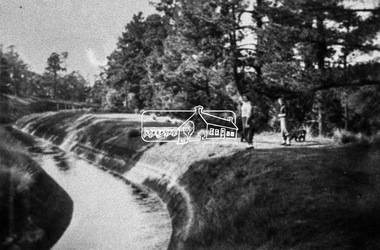 Eltham District Historical Society Inc
Negative - Photograph, Maroondah Aqueduct (Copy), 1991
Roll of 35mm colour negative film, 9 strips Colour print 10 x 15 cmFuji HG 200 CA-1maroondah aqueduct -
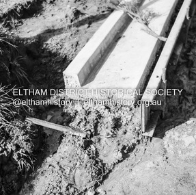
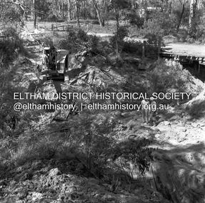 Eltham District Historical Society Inc
Negative - Photograph, J.A. McDonald, Henley Road at Watsons Creek, Mar. 1961
Henley Road at Watsons Creek Looking easterly along new alignment, 22 March 1961 C. Browns Excavator Contractor Wolf Cr PellingRecord of various Shire of Eltham infrastructure works undertaken during the period of 1952-1962 involving bridge and road reconstruction projects, sometimes with Eltham Shire Council Project Reference numbers quoted. It was during this period that a number of significant improvements were made to roads and new bridges constructed within the shire that remain in place as of present day (2022). In many situations, the photos provide a tangible visible record of infrastructure that existed throughout the early days of the Shire. The album was put together by or under the direction of the Shire Engineer, J.A. McDonald.infrastructure, shire of eltham, 1961-03, bend of islands, cr. charis pelling, henley road, henley road bridge, kangaroo ground, oxley bridge, watsons creek, w.e. wolf, bridge construction, road construction -
Stawell Historical Society Inc
Map, Callawadda, Counties of Borung & Kara Kara, 1959
Callawadda, Counties of Borung & Kara Karastawell -
Stawell Historical Society Inc
Map, Parish of Stawell, North Ward & Big Hill etc
Shows Newington Co, Moonlight Co, St George Co, Victoria Co, Galatea Co Shows Tramline over Big Hill, Leviathan Co, Parish of Stawell, North Ward & Big Hill etcstawell -
Bendigo Historical Society Inc.
Map - HUNTLY, Circa 1870's
Map: Huntly, Hand draughted parish planmap, bendigo, parish plan, huntly -
Stawell Historical Society Inc
Map, County of Ripon, 1858
County of Riponstawell -
Bendigo Historical Society Inc.
Map - NEILBOROUGH, 21/01/1875
Map: Parish of Neilborough, County of Bendigo. Hand Draughted Parish plan. Map dated 21/1/1875.map, bendigo, parish plan, neilborough -
Beechworth Cemetery Trust
Map - Beechworth Cemetery reproduction of original map, Beechworth Cemetery Reproduction - Treasurer copy
Reproduction map displaying all grave sites in Beechworth Public Cemetery. Rotunda, fountain, nursery, memorial wall, pioneer sectionmap displays the plan of grave sitesLaminated Photocopy of original cemetery map with additional information hand-written on the map. All graves at the cemetery set out in denominational sections with hand-written information on additional graves added to sections in Roman Catholic A & C, Church of England A-F, Presbyterian A-C, Methodist/Uniting B and Wesleyan A. Multidenominational hand-written note on Jews section with Trust Minutes 4.7.'83 written next to this addition. Additions hand-drawn of fountain, memorial wall, nursery and pioneer cemetery.rotunda, fountain, nursery, memorial wall, pioneer section, graves, chinese section, un-numbered grave sites, cemetery -
Bendigo Historical Society Inc.
Map - MARONG, Circa 1871
Map; Marong, Hand Draughted parish planmap, bendigo, parish plan, marong -
Tatura Irrigation & Wartime Camps Museum
Map - Plaster Cast, Map of Australia, 1940's
Made by POW at Dhurringile Internment CampMap of Australia, plaster cast, bell shaped, in which is a copper penny and a rosella atop Cape York. Dated 1940 words "Tatura Vic" below map of Australia1940 Tatura- Dhurringile intern Campplaster caste, map of australia, layton family, dhurringile camp, tatura, camp, ornament, plaster -
Kew Historical Society Inc
Journal, Kewriosity : November 1985
Our window [Alan Sumner, The Four Seasons] / p1. Linear Park will not affect E6 [Outer Circle railway reserve] / p1&5. Dates for November / p2&8. [Community] Notices / p2. Update: Notes from Council - [Council] Budget Go-ahead / Cr Phyllis Hore [Mayor of Kew] / p3. Traffic management / p3. In Brief [Recycling transfer; Walmer Street Appeal quashed; Deregulation of shared housing; Review sought on full day care decision; Whither Willsmere?; Cable tram centenary exhibition; Election possible; Community Assistance Grants] / p4. Death of Councillor Murray Wood / p4. 40 years of home-help in Kew / p5. Three year old Kinder [Argyle Road; Davis Street] / p5. Youth Page - New publications for youth [Streetwise comics; Making unemployment work] / p6. How we passed our time - 2 [social history] / Bill Stent p7. A Group Apprenticeship Scheme for Eastern Suburbs / p7. Kew Community House / p8. Room for one more [student hosting] / p8. North Kew Tennis Club / p8. Kew Young Liberals / p8. Kew Band in concert / p8.Kewriosity was a local newsletter combining Kew Council and community news. It was published between November 1983 and June 1994, replacing an earlier Kewriosity [broad] Sheet (1979-84). In producing Kewriosity, Council aimed to provide a range of interesting and informative articles covering its deliberations and decision making, together with items of general interest and importance to the Kew community and information not generally available through daily media outlets.non-fictionOur window [Alan Sumner, The Four Seasons] / p1. Linear Park will not affect E6 [Outer Circle railway reserve] / p1&5. Dates for November / p2&8. [Community] Notices / p2. Update: Notes from Council - [Council] Budget Go-ahead / Cr Phyllis Hore [Mayor of Kew] / p3. Traffic management / p3. In Brief [Recycling transfer; Walmer Street Appeal quashed; Deregulation of shared housing; Review sought on full day care decision; Whither Willsmere?; Cable tram centenary exhibition; Election possible; Community Assistance Grants] / p4. Death of Councillor Murray Wood / p4. 40 years of home-help in Kew / p5. Three year old Kinder [Argyle Road; Davis Street] / p5. Youth Page - New publications for youth [Streetwise comics; Making unemployment work] / p6. How we passed our time - 2 [social history] / Bill Stent p7. A Group Apprenticeship Scheme for Eastern Suburbs / p7. Kew Community House / p8. Room for one more [student hosting] / p8. North Kew Tennis Club / p8. Kew Young Liberals / p8. Kew Band in concert / p8. publications -- city of kew (vic.), kewriosity, council newsletters, community newsletters