-
 Bendigo Historical Society Inc.
Map - CITY OF SANDHURST SHEET NO 4, 25/04/1882
Map: City of sandhurst sheet No. 4. Parish plan ( number 224 in Map Cupboard 1)map, bendigo, parish plan, sandhusrt -
 Federation University Historical Collection
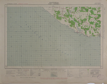
Map, Port Campbell, 1942, 1942
Printed colour map on paperport campbell -
Glen Eira Historical Society
Map - Caulfield Fire Station, No 26, Tree Reserve, Dandenong Road
A one page photocopy of an undated, unattributed, hand drawn map (200mm x 290mm) of the location on Tree Reserve, Dandenong Road, of the Caulfield Fire station, No 26. The map includes handwritten notes showing various nearby property owners. The file also includes a photocopy of a one page, undated and unattributed printout of the site address and site lease date.caulfield east, caulfield fire station, dandenong road, derby road, racecourse road, tree reserve, shire of caulfield, federal bank, st james building society, delves murchison, fire stations -
Canterbury History Group
Map - Victorian Railways East Camberwell to Laburnum. Diagram No.3' 58, 1/05/1958 12:00:00 AM
Diagram showing proposed signal and interlocking arrangements for the East Camberwell to Laburnam line 1958canterbury, canterbury station, victorian railways, railway lines -
 Robin Boyd Foundation
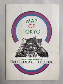
Map, Imperial Hotel, Map of Tokyo
Provided by Imperial Hotel, Tokyo Robin Boyd stayed here in the 1960swalsh st library -
Bendigo Historical Society Inc.
Map - INGLEWOOD, 17/12/1877
Map: Parish of Inglewood, County of Gladstone. Parish plan. Earliest date on map 31/12/75.map, gladstone, parish plan, inglewood -
Bendigo Historical Society Inc.
Map - CAMPBELL COLLECTION: BENDIGO & DISTRICT MAPS
Map. Lockwood, Parishes of Lockwood and Shelbourne. Scale 20 chains to 1 inch.Total area 4405 acres. Bullock Creek to the right, Spring Creek at Centre. Newbridge is 11 miles N E, To Marong, Bendigo Lockwood roads are on the left. (number 375 in map cupboard 1)map, bendigo, agricultural lands -
Bendigo Historical Society Inc.
Map - PARISH OF SANDHURST 1961, 1961
At Bendigo Parish of Sandhurst. Sheet F.Dept of Lands and Surveybendigo, land sales, parish map -
Bendigo Historical Society Inc.
Map - SUTTON GRANGE : COUNTY OF BENDIGO, 21-7-22
Map. Sutton Grange, County of Bendigo, County of Talbot, Mandurang, Sedgwick, Ravenswood, Hawkestone, Harcourt, Faraday. Myrtle Creek. Victorian Water Supply - Main Line of Aquaduct from Malmsbury to Sandhurst. By authority A.J. Mullett, Government Printer, Melbourne. Photo-Lithographed at the Department of Lands and Survey, Melbourne by W.J. Butson, 21-7-22. Price 1/-. (number 125 in map cupboard 1)A.J. Mullett, Government Printer, Melbourne.map, bendigo, sutton grange -
 Melbourne Tram Museum
Legal record, Melbourne & Metropolitan Tramways Board (MMTB), "Supply and Erection of gates and paling fence and repairs to existing fences at the Royal Park car shed", Mar. 2020
.1 - Legal document - tender document - typed carbon copy titled "Supply and Erection of gates and paling fence and repairs to existing fences at the Royal Park car shed" with specification for the work, dated 25/3/1920 asking for prices - single sheet to be returned to the Secretary. .2 - same document but the lower portion has a price and name of the tenderer, John Broderick of Napier St Footscray, for 21 pounds. Dated 7/4/1920.trams, tramways, mmtb, cable trams, royal park, tenders, depots, zoo tram -
 Ballarat Heritage Services
Map, Central Europe and the Mediterranean during World War One
Map of the World as it was during World War One. map of the world, world war one, france, spain, england, ireland, germany, austria-hungary, rumania, servia, albania, greece, bulgaria, russia, asia minor, turkey, egypt, tripoli, morocco, algeria, tunis -
Clunes Museum
Map, PRODUCED BY CHARLES FENTON, TRADERS OF FRASER STREET CLUNES
4 X SHETS OF PAPER COMMECTED WITH STICKY TAPE SHOWING SHOPS OF FRASER STREET CLUNES WITH THE NAMES OF TRADERS AT EACH SHOP LOCATION. ALTHOUGH UNDATED IT IS EXPECTED THAT THIS MAP DATES TO APPROX 1870C1870fraser street, traders of clunes -
Bendigo Historical Society Inc.
Map - NOLAN, 5/03/1888
Map: Nolan, County of Bendigo. Parish plan (number 284 in map cupboard 1)map, bendigo, parish plan, nolan -
 National Vietnam Veterans Museum (NVVM)
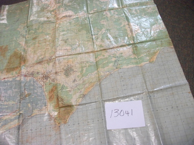
Map, Intelligence Map
Vinyl coated topographical map of part of Vietnam featuring main roads, towns and city locations current or ruined. River locations etc. Names all in Vietnamese language.map, vietnam -
 Melbourne Tram Museum
Legal record, Hawthorn Tramways Trust (HTT), "Hawthorn Tramways Trust - By-Law No. 2", "Protection of Native Game at 'Wattle Park' Surrey Hills", Original 1917
Set of two extracts from the Victorian Government Gazette, printed onto A4 sheets concerning Wattle Park. .1 - "Hawthorn Tramways Trust - By-Law No. 2" - By-law Regulating, Controlling and Managing Wattle Park - Gazette of 29 August 1917, page 2714. Signed by D. Dureau, H. Bell and A Hislop of the HTT 21/8/1917. Gives the rules for the use of the park. Replaced by MMTB By-Law No. 7 - see Reg item 2019. .2 - "Protection of Native Game at 'Wattle Park' Surrey Hills" - Proclamation - The Game Act 1915 - Gazette of 9/5/1917, page 1418. Gives the location details and refers to the Act. Note these Gazettes can be sourced from the Victorian Government Parliament Web site.trams, tramways, wattle park, htt, by laws, regulations -
Bendigo Historical Society Inc.
Map - MARONG, Circa 1871
Map; Marong, Hand Draughted parish planmap, bendigo, parish plan, marong -
 Warrnambool and District Historical Society Inc.
Education kit - Book, The Academic Edition of Pianoforte Studies & Exercises, Circa 1900
Music folio for Senior students. This music folio is an example of studies in music at the beginning of the 20th century. Cream light card cover with title page in various texts in black. Pale red stylised border around text. Back cover has information regarding different grade levels in music. 36 Pages. Pages hand stitched in cotton with cotton cloth binding. Loose brown paper cover.V.E. Adams handwritten in top RH corner of brown paper cover. pianoforte studies and exercises, no 129, gordon saunders -
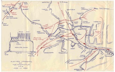
 Bayside Gallery - Bayside City Council Art & Heritage Collection
Map, Department of Crown Lands and Survey et al, Moorabbin, County of Bourke, Government Roads, 1920
The cadastral map of the Parish of Moorabbin in Victoria (L.6104) shows parish boundaries and land ownership 1920 when Sandringham was a Town. The government roads have been coloured in red pencil.moorabbin, county of bourke, map, plan, land subdivision, land titles, foreshores, hampton, beaumaris, highett, cheltenham, department of lands and survey, land owners, cartographic material, brighton, sandringham, town of sandringham, government roads -
Clunes Museum
Map - SURVEYERS MAP OF CLUNES, J. FINNIE, 1883
A SURVEYORS MAP OF CLUNES. GEOLOGICALLY AND TOPOGRAPHICALLY SURVEYED BY R.A.F. MURRAY.LITHOGRAPHED BY R. SHEPHERD AND PRINTED BY J. FINNIE MINING DEPARTMENT, MELBOURNE,1883document, surveyers map of clunes, map of clunes -
Stawell Historical Society Inc
Map, Land Map of Victoria 1898, Supplement to "The Leader", 1898
Land Map of Victoria 1898, Supplement to "The Leader"stawell -
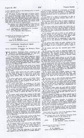
 Ballarat Tramway Museum
Map, Ken McCarthy, Electric Tramways of Newcastle 1923 - 1950, c1960
Hand drawn red and blue biro map of Newcastle electric tram lines - period 1923 - 1950, showing principal railway lines, tram tracks, crossovers depot layout, level crossings on plain foolscap paper.trams, tramways, newcastle, steam trams, trams, map -
Bendigo Historical Society Inc.
Map - BENDIGO IRRIGATION SETTLEMENT, 20/10/1908
Map: Bendigo Irrigation Settlement, Parishes of Sandhurst and Wellsford, County of Bendigo, Parish planmap, bendigo, irrigation settlement, bendigo irrigation settlement -
Bendigo Historical Society Inc.
Map - BENDIGO, GREATER CITY OF, 2013
Map, City of Greater Bendigo, Epsom/Huntly, Heathcote, Strathfieldsaye/ Junortoun, Mandurang, Sebastian, Mia Mia, Maiden Gully, Ravenswoon, Axedale, Myers Flat, Redesdale, September 2013, on front. Lockwood South, Marong, Raywood, Neilborough, Elmore, Goornong, on reverse side. ( number 413 in Map Cupboard 1 ). Donated by Bendigo Council.bendigo, hospital -
 Mission to Seafarers Victoria
Map, Surveyor General's Office, Plan of Williamstown, County of Bourke, 20 November 1855
Plan of Williamstown in 1855The map helps locate the Wesleyan church on Ann Street which was converted in the Sailors' Rest in 1875.ann street, wesleyan church, sailors' rest, williamstown -
Stawell Historical Society Inc
Map, Aerial Photograph of Stawell, c1980
Aerial Photograph of Stawellstawell -
Port Melbourne Historical & Preservation Society
Legal record, Ewan Ogilvy's Bayside Papers, Box Three - Port Melbourne Bayside Development Development Agreement - contract of sale, 1987
Ewan Ogilvy, former Melbourne Councillor and also of Community Services Victoria, Inner Urban Ministerial Advisory Committee and Uniting Church's Centre for Urban Research and Action (CURA), was instrumental in social justice approaches to town planning. He and CURA's Social Justice and the City Project funded Port Melbourne community groups protesting against the SCDC development in 1987. His files were presented to the Society in May 2001 on his preparation for leaving Victoria.From Ewan Ogilvy's chronologically organised 'Bayside Papers' relating to the proposed development of Port Melbourne industrial land in the late 1980s: Stapled photocopies of Port Melbourne Bayside Development Development Agreement - contract of saleRust marks from bulldog clip top front cover. Signed 'Ewan Ogilvy'town planning, town planning - proposals shelved - bayside, public action campaigns, environmental issues, public housing, missions to seamen, ewan ogilvy, centre for urban research and action, sandridge city development co pty ltd, scdc, linton r lethlean, barry pullen - mlc -
Ringwood and District Historical Society
Legal record - Conditions of Sale (C.E.Carter), Heathmont - Lots 22 & 23, Plan of Subdivision No 2436814, H Gerlach to W H Saunders - 1929
Particulars and Conditions of Sale of Property , from Herman Gerlach to William Henry Saunders. -
Clunes Museum
Map - CLUNES MAP SHOWING STREETS AND LOT NUMBERS, PRODUCED BY CHARLES FENTON, 1987
FORMERLY USED FOR DISPLAY IN CLUNES MUSEUM BEFORE RENOVATIONWOOD LOOK FRAMED MAP OF CLUNES, UNDER GLASS. COMPILED BY CHARLES FENTON 1987. CLUNES SHOWING HOUSES, MINES, STREETS AND SURROUNDING ESTATES. LEGEND BOTTOM LEFT.clunes, map -
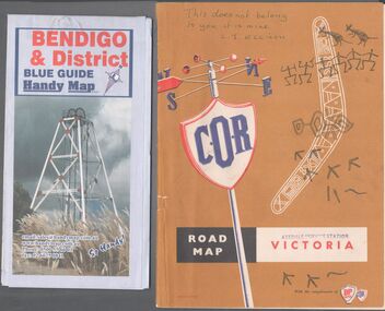 Bendigo Historical Society Inc.
Map - Road maps
BHS CollectionTwo road maps. On, Bendigo & District blue guide handy map the other a road map of Victoria. On the back of the Bendigo map the date October 2000. On the Victoria map the words in pen "This doesn't belong to you, it is mine". L.J. Ellison and a blue stamp of Axedale service station. Aileen and John Ellison Collection.road map, victoria, bendigo -
Whitehorse Historical Society Inc.
Map, Pocket guide to walking and wheeling in Whitehorse, 2008
Map showing walks, cycle tracks and off lead areas for dogs in Whitehorse.Map showing walks, cycle tracks and off lead areas for dogs in Whitehorse. Includes walking and cycling groups.Map showing walks, cycle tracks and off lead areas for dogs in Whitehorse. walking trails, bicycle paths, city of whitehorse