Showing 1641 items
matching documentation
-
 Glenelg Shire Council Cultural Collection
Plan - Ship Plan / Mould, n.d
Wooden pattern for mould for boat fitting. Rectangular base, 2 mounds attached to top of base, equidistant from short ends. Top painted green, underneath base, painted white. -
 Kew Historical Society Inc
Plan, Melbourne & Metropolitan Board of Works : Borough of Kew : Detail Plan No.1582, 1904
The Melbourne and Metropolitan Board of Works (MMBW) plans were produced from the 1890s to the 1950s. They were crucial to the design and development of Melbourne's sewerage and drainage system. The plans, at a scale of 40 feet to 1 inch (1:480), provide a detailed historical record of Melbourne streetscapes and environmental features. Each plan covers one or two street blocks (roughly six streets), showing details of buildings, including garden layouts and ownership boundaries, and features such as laneways, drains, bridges, parks, municipal boundaries and other prominent landmarks as they existed at the time each plan was produced. (Source: State Library of Victoria)This plan forms part of a large group of MMBW plans and maps that was donated to the Society by the Mr Poulter, City Engineer of the City of Kew in 1989. Within this collection, thirty-five hand-coloured plans, backed with linen, are of statewide significance as they include annotations that provide details of construction materials used in buildings in the first decade of the 20th century as well as additional information about land ownership and usage. The copies in the Public Record Office Victoria and the State Library of Victoria are monochrome versions which do not denote building materials so that the maps in this collection are invaluable and unique tools for researchers and heritage consultants. A number of the plans are not held in the collection of the State Library of Victoria so they have the additional attribute of rarity.Original survey plan, issued by the MMBW to a contractor with responsibility for constructing sewers in the area identified on the plan within the Borough of Kew. The plan was at some stage hand-coloured, possibly by the contractor, but more likely by officers working in the Engineering Department of the Borough and later Town, then City of Kew. The hand-coloured sections of buildings on the plan were used to denote masonry or brick constructions (pink), weatherboard constructions (yellow), and public buildings (grey). Public buildings, coloured grey on the Plan 1582 include the police station and post office, churches and schools. The earliest church school, Common School No.356 was located at the rear of the Congregational Church in Peel Street. It was constructed in 1859. The first buildings of Kew Primary School No.1075 on the other side of Peel Street were constructed in 1871. The school in 1903 only occupied a small fraction of its current site. In 1903, where the rear playground is now located, were two weatherboard and one brick villa. Trinity Grammar School was founded in 1902 and opened in the Parish Hall at the rear of Holy Trinity Anglican Church. It was not to move to its current site until 1906. The outline of the building housing the Kew Fire Brigade in the centre of the north side of Walton Street is shown but not named on the plan. Further down Pakington Street stood the two-storey Italianate mansion ‘Overton’. The home of Stanford Chapman, it was to be featured in the Imperial Institute series of bromide photographs of Victoria, Vol. 1: Homes and scenery. It was later to become a boarding house before it was later demolished.melbourne and metropolitan board of works, detail plans, maps - borough of kew, mmbw 1582, cartography -
Moorabbin Air Museum
Plan (item) - Bristol Aeroplane 170 schematic drawings, Scrap View of Boom Attachment Stn. O to Stn. 63 - STB
Bristol Aeroplane Company Ltd -
Glenelg Shire Council Cultural Collection
Plan - Plans / Line Drawing Port of Portland Slipway Tuna Vessel 'Roza-S', c. 1986
Front: '24' - black texta, top right cornerport of portland -
Glenelg Shire Council Cultural Collection
Plan - Plans / Line Drawings - Port of Portland Authority Slipway, Bilge Blocks Steel Fishing Vessel, Victoria, 26/08/1987
Port of Portland AuthorityFront: '44' - black texta, top right corner -
University of Melbourne, Burnley Campus Archives
Plan, Plan showing proposed adjustment of boundaries of the Horticultural Society's Gardens in Richmond Park, c.1880-1884
Copy of B92.0535 framed and glazed.gardens, richmond, hoticultural society of victoria, river yarra -
 Federation University Historical Collection
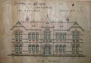
Plan, Ballarat School of Mines New Classrooms (now Administration Building), 1899, 16/02/1899
In 1900 this building was described as 'handsome in design, well lit, well ventilated, commodious - containing Council room, office, chemical laboratory, mineralogical laboratory, students room and six lecture rooms. Original hand coloured plan on linen of the Ballarat School of Mines New Classrooms (in 2014 known as the Federation University Australia SMB campus Administration Building). The plan shows the front elevation, section on line, ground and 1st floor plan. Copy in black frame with cream mount.ballarat school of mines, new classrooms, administration building, architectural plans, a building -
Glenelg Shire Council Cultural Collection
Plan - Plans / Line Drawings - Port of Portland Authority Slipway Fishing Vessel Soluna, Victoria, 06/10/1989
Port of Portland AuthorityFront: '33'- black texta, top right corner. 'JOB NO 3110' - black pen -
Moorabbin Air Museum
Plan (Item) - Drawing External Emergency Finish & Markings - CH47C Chinook A/C Drawing No DA70384002
-
University of Melbourne, Burnley Campus Archives
Plan, Burnley Student Social Garden, 1995
1 coloured and 1 black and white copy Landscape Plan by Brooke Ryan. Scale 1:50.1995brooke ryan, students, gardens, burnley -
 University of Melbourne, Burnley Campus Archives
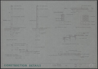
Plan, Construction Details Student Gardens Burnley Campus, 1990
Tracing paper copy, Construction details for student gardens. Dated1 9.09.1990. By JK (Jill Kellow) . Scale 1:100.student gardens, burnley, vcah burnley, jill kellow -
 Federation University Historical Collection
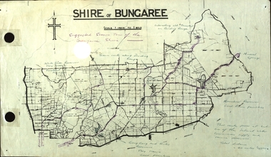
Plan, Shire of Bungaree
The former Shire of Bungaree is now part of Moorabool Shire.Plan of the Shire of Bungaree. Scale is 1 inch to 1 mile with the total distance approximately 40 miles. Includes Gong Gong Reservoir, Kirks Reservoir, White Swan Reservoir, Wilson's Reservois and Moorabool Reservoir. Purple line in purple pencil indictaes suggested scenic tour of the Bungaree Shirebungaree, water supply, barkstead, humffray street, ballarat, doveton (north) stret, ballarat, ballarat water commission, great dividing range, wombat state forest, mineral water springs, gong gon reservoir, kirks reservoir -
Port Melbourne Historical & Preservation Society
Plan - Detail of Grille and Stairs, Port Melbourne Town Hall, Port Melbourne City Council, 1916
Plan - Details of grille to entrance and over main stair, details of main stairs. (1915 Town Hall)port melbourne town hall -
Federation University Historical Collection
Plan, Hotels on Main Road Ballarat
hotels, ballarat, ballarat east, tom reidy -
Port Melbourne Historical & Preservation Society
Plan - Tide limits at Inner East berth Station Pier for Tasmanian ferry Abel Tasman, Engineering Division, Port of Melbourne Authority, 1984
Plan: Tasmanian ferry at Inner East Station Pier - tide limits at working draft (lowest tide). This plan relates to the vessel Abel Tasmanabel tasman, piers and wharves - station pier, melbourne harbor trust - port of melbourne authority -
Glen Eira Historical Society
Plan - Bokhara Road, 28, Caulfield South
A hand drawn plan (75mm x 147mm) of the house at Bokhara Road, 28, Caulfield, undated and unattributed. The plan includes notes about the dimensions and fittings of the house.bokhara road, caulfield south -
 Federation University Historical Collection
Plan, Ballarat Goldfield - Geological Survey of Victoria, 1981, 1981
Coloured geological plan showing the Ballarat goldfields. It includes coloured scales and nuggets from the Ballarat Goldfield. It also shows leads and mines.ballarat, geology, geological, gold nuggets, mining, mining companies, gold leads -
 Kew Historical Society Inc
Plan - Subdivision Plan, J Hurrey, Section 115 in the Parish of Boroondara Near Richmond Bridge, 1853
Despite the plans claims that it is a subdivision near the Richmond Bridge, Section 115 was located at what is now Camberwell Junction. While the plan only lists government roads rather than named streets, the section was located on the east side of Burke Road, stretching up the hill from the current Junction. Research on Trove, conducted by Kerry Fairbank, discovered an advertisement for unsold lots in Section 115 which clarifies the extent and location of subsequent land sales in the original section. The original article can be viewed through the link in the catalogue record. The interesting link to Kew is the reference to James Beavan as the purchaser of lots 14 and 15. The historian Gwen McWilliam has notes that a Mr Beavan changed his name from Bevan. The Bevans were descendants of the Derricks family of Kew. This subdivision plan is the earliest original map or plan in the collection which shows parts of what is now the City of Boroondara, dating from circa 1853. It provides important information for researchers on subsequent subdivisions following the original land sales in [Camberwell] Boroondara. The site, on the east side of Burke Road is a highly-significant and historic site. This is believed to be the only extant copy of the subdivision in public collections.A small plan on parchment listing 28 lots, between one and two acres each, for sale in Section 115 in the Parish of Boroondara, dating from 1853 when the portion was subdivided.Obverse: Lot 16 "Joseph Duval", Lots 14 & 15 "James Beavan". Other annotations (measurements) are unreadable. Reverse: "KH-981 / Section 115 in the Parish of Boroondara / Near Richmond Bridge / 1640T. / J Duval / 14-15 J. Beavanparish of boroondara, subdivision plans - camberwell, section 115 - boroondara, subdivision plans -- camberwell (vic), riverscape road, burke road, camberwell junction -
 Federation University Historical Collection
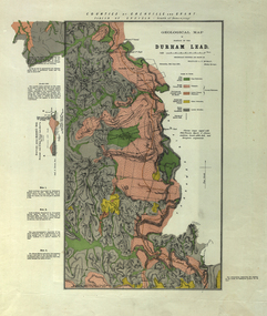
Plan, Durham Lead, 1870
Geological Map of portions of Durham Lead. durham lead, reginald a.f. murray, plan, garibaldi, garibaldi company, geology, chryseis company, hardies hill, city of manchester company, williamson's creek, south grenville company, enfield company, pioneer company, duke of northumberland company, monmowth gully, extinct volcano crater, mount mercer basalt -
 Kew Historical Society Inc
Plan - Subdivision Plan, Jas R Mathers Son & McMillan, Macartney Estate, East Kew, c. 1925
Pru Sanderson, in her groundbreaking ‘City of Kew Urban Conservation Study : Volume 2 - Development History’ (1988), summarised the periods of urban development and subdivisions of land in Kew. The periods that she identified included 1845-1880, 1880-1893, 1893-1921, 1921-1933, 1933-1943, and Post-War Development. These periods were selected as they represented periods of rapid growth or decline in urban development. An obvious starting point for Sanderson’s groupings involved population growth and the associated economic cycles. These cycles also highlighted urban expansion onto land that was predominantly rural, although in other cases it represented the decline and breakup of large estates. A number of the plans in the Kew Historical Society’s collection can also be found in other collections, such as those of the State Library of Victoria and the Boroondara Library Service. A number are however unique to the collection.Subdivision plans are historically important documents used as evidence of the growth of suburbs in Australia. They frequently provide information about when the land was sold on which a built structure was subsequently constructed as well as evidence relating to surveyors and real estate and financial agents. The numerous subdivision plans in the Kew Historical Society's collection represent working documents, ranging from the initial sketches made in planning a subdivision to printed plans on which auctioneers or agents listed the prices for which individual lots were sold. In a number of cases, the reverse of a subdivision plan in the collection includes a photograph of a house that was also for sale by the agent. These photographs provide significant heritage information relating house design and decoration, fencing and household gardens.The Macartney Estate subdivision advertised 21 lots for sale on either side of Macartney Street (now Macartney Avenue) and Evans Road in what was then designated as East Kew. Most of the houses shown on the south side of Macartney Street then, as now, have rear entrances on Mount Street, however a number of these blocks have since been further subdivided to allow for the building of new houses on the rear of a block. Brougham Place is marked on the plan but is now called Daniell Place."C"subdivision plans - east kew, macartney estate, macartney street, mount street, evans road, brougham place -
 Kew Historical Society Inc
Plan - Subdivision Plan, Bella Vista Estate, 1929
Pru Sanderson, in her groundbreaking ‘City of Kew Urban Conservation Study : Volume 2 - Development History’ (1988), summarised the periods of urban development and subdivisions of land in Kew. The periods that she identified included 1845-1880, 1880-1893, 1893-1921, 1921-1933, 1933-1943, and Post-War Development. These periods were selected as they represented periods of rapid growth or decline in urban development. An obvious starting point for Sanderson’s groupings involved population growth and the associated economic cycles. These cycles also highlighted urban expansion onto land that was predominantly rural, although in other cases it represented the decline and breakup of large estates. A number of the plans in the Kew Historical Society’s collection can also be found in other collections, such as those of the State Library of Victoria and the Boroondara Library Service. A number are however unique to the collection.The Kew Historical Society collection includes almost 100 subdivision plans pertaining to suburbs of the City of Melbourne. Most of these are of Kew, Kew East or Studley Park, although a smaller number are plans of Camberwell, Deepdene, Balwyn and Hawthorn. It is believed that the majority of the plans were gifted to the Society by persons connected with the real estate firm - J. R. Mathers and McMillan, 136 Cotham Road, Kew. The Plans in the collection are rarely in pristine form, being working plans on which the agent would write notes and record lots sold and the prices of these. The subdivision plans are historically significant examples of the growth of urban Melbourne from the beginning of the 20th Century up until the 1980s. A number of the plans are double-sided and often include a photograph on the reverse. A number of the latter are by noted photographers such as J.E. Barnes.Bella Vista (later ‘Malinda’) was a large Federation house designed by the architect Robert Haddon for Abel Hoadley. The house was built in 1902 and occupied the eastern corner of Thomas Street and Cotham Road. It was a single-storey, red brick house, set back from the road, featuring a central tower topped by a pagoda-like red terra cotta roof, on top of which was perched a very large terra cotta dragon. The Bella Vista subdivision of 1929 included Hoadley’s house as well as nine allotments facing Cotham Road and Alfred and Thomas Streets. In 1941, the land on which Hoadley’s house stood was to be further subdivided. Bella Vista is believed to have lasted until it was demolished in the 1980s.subdivision plans - kew, bella vista estate -
Moorabbin Air Museum
Plan (item) - Bristol Aeroplane 170 schematic drawings, Access Door- Bottom Skin- Rear Spar Centre Plane
Bristol Aeroplane Company Ltd -
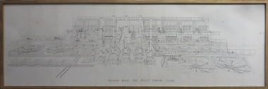 Federation University Historical Collection
Plan, Crushing Works, Port Phillip Company
Detailed mechanical engineering drawing of the Port Phillip Company Crushing Works at Clunes, VictoriaFramed plan of the Port Phillip Company's crushing works. Plaque: "Donated to the Metallurgy Department of Ballarat University College by noted Ballarat Author and Historian, A W Strange. 13/6/91" port phillip mine, plan, rivett henry bland, clunes, crushing works, mechanical engineering -
University of Melbourne, Burnley Campus Archives
Plan, Ian Porter, Civic Square, 1994
Laminated, coloured , Preliminary Plan by Ian Porter dated 15.10.1994, No 3 of 3. Scale 1:200.civic square, ian porter -
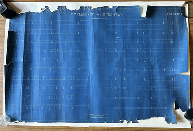 Port Melbourne Historical & Preservation Society
Plan, Pt Melbourne Cable Tramway, 1890s
One of three sheets of blueprints showing street configuration in Beach Street and Sandridge Road along Port Melbourne cable tram route. Indistinguishable signature of 'George ------ Esq., lower rightNotations in red crayon or penciltransport - tramways, transport - roads -
Port Melbourne Historical & Preservation Society
Plan, Graeme Bentley Pty Ltd, Port Melbourne Foreshore Landscape Master Plan MP 5 (B), February 1993
The Port Melbourne Foreshore Landscape Master Plan was created by Landscape Architectural firm of Graeme Bentley Pty Ltd for the City of Port Melbourne. MP5 (B) has detailed alterations to the area around the Port Melbourne Yacht Club. The plan was not actioned.built environment - recreational facilities, beach street, port melbourne foreshore, port melbourne yacht club -
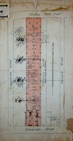 Kew Historical Society Inc
Plan - Subdivision Plan, Thornton Estate, 1918
The ‘Thornton Estate’ was the final subdivision of ‘Thornton’ in Studley Park Road. Thomas Cubitt Balmain originally owned Thornton, next to John Carson’s ‘Clutha’. Before its final subdivision, the Thomson family owned it. The Estate was a subdivision of 15 residential allotments running between Studley Park Road and Stevenson Street. The allotments faced these streets as well as Thornton Street, which the vendor undertook to make. Contemporary newspaper advertisements advised that ‘The estate possesses many advantages, notably its private and secluded, though convenient, position, splendid frontages and depths, and being close to the electric tram and Kew train, also within easy walking distance of the Victoria-street cable tram’. The terms offered purchasers were ten per cent deposit, with the balance to be paid in ten equal half-yearly payments at a rate of 5 per cent.subdivsion plans - kew, studley park, thornton estate -
Glenelg Shire Council Cultural Collection
Plan - Plans / Line Drawing Port of Portland Slipway Steel Vessel 'Cape Peron', 13/12/1989
Front: 'Bilge keel, 60" Bilge keel 62" ' - pencil on two of the line drawingsport of portland -
Glen Eira Historical Society
Plan - Clarinda Street, 27, Caulfield South
A one page typed letter from Plante and Henty Solicitors on behalf of the Executor of the will of the late Grace Ellen Gillespie, to W V Scott of S P Simmonds and Co, dated 04/03/1957, requesting valuation of 27 Clarinda Street, Caulfield South for Probate purposes. The letter is accompanied by the Certificate of Title for the property which includes a map (87mm x 67mm) of the property. It is also accompanied by a floor plan (300mm x 205mm) of the house. The file also includes a two page copy of correspondence from W V Scott to Plante and Henty, dated 22/03/1957, providing the valuation of 27 Clarinda Street. The file also includes three pages of handwritten working notes for the purposes of the valuation which provide dimensions and estimated value of the property.scott w v, gillespie grace ellen, clarinda street, solicitors, s p simmonds and co estate agents, property values, land values, plans, architectural features, land titles, certificates, caulfield south, prahran east, elsternwick county of bourke, sycamore road, south caulfield, glenhuntly road -
 Kew Historical Society Inc
Plan - Subdivision Plan, Charteris Estate, East Ivanhoe, 1939
The Charteris Estate in Ivanhoe was sold in a number of sections. Copies of a subdivision plan of the first section is in the State Library of Victoria collection. This later section of the Charteris Estate includes lots in the Government Boulevard, Castella Street, McArthur Road, Burke Road North, Charteris Drive and Warncliff Road.Subdivision plans like that for the Charteris Estate are invaluable records for local historians identifying when lots in streets were promoted for sale.Four-fold brochure advertising the Charteris Estate in East Ivanhoe in 1939. Streets named on the plan include: the Government Boulevard, Castella Street, McArthur Road, Burke Road North, Charteris Drive and Warncliff Road. The brochure contains photos of Charterisville, the home of F De Castella Esq and also of attractive rolling hills. Annotations in pencilcharteris estate - east ivanhoe (vic), subdivision plans - east ivanhoe (vic)