Showing 27546 items
matching rd ?
-
 Ringwood and District Historical Society
Photograph, Guest's Bakehouse, Mt. Dandenong Rd. Corner Braeside Ave. 1964". Catalogue card states demolished 1972
Typed below photograph, "Guest's Bakehouse, Mt. Dandenong Rd. Corner Braeside Ave. 1964". Catalogue card states demolished 1972. -
 Ringwood and District Historical Society
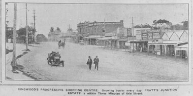
Photograph, Maroondah Highway Central, Ringwood. Ringwood Shopping Centre, Whitehorse Rd- 1924
Black and white photograph (3 copies) Typed below one photograph: "Ringwood Shopping Centre, Whitehorse Rd. - 1924". Typed below other copies: "Ringwood's progressive shopping centre. Growing busier every day. Pratt's Junction Estate is within Three Minutes of this Street". Typed on back of one copy: "Copied from a circular by F.V. Parker 24/11/23 advertising Pratts Junction Estate. 86 lots. Oliver St. Georges Rd. & Junction St., between Mullum Creek & Whitehorse Rd. £3 deposit and 1£ per month." -
 Ringwood and District Historical Society
Photograph, Corner of Oban Rd. and Kubis Drive, North Ringwood 1982
Written on back of photograph, "21/4/82. Corner of Oban Rd. and Kubis Drive. Menzies [Drive] Cr. notches(?) hill on centre right." -
 Ringwood and District Historical Society
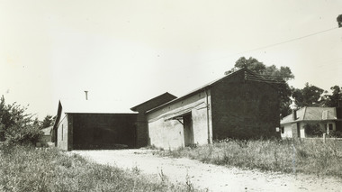
Photograph, Warrandyte Rd (unmade) Ringwood. O.J. Pratt shop on corner. Benty's timber yard on right (Undated)
Bamford Timber Merchants on leftTyped below photograph, "Warrandyte Rd. "O.J. Pratt 1914" shop on corner, later demolished to widen road. Benty's timber yard on right." -
 Ringwood and District Historical Society
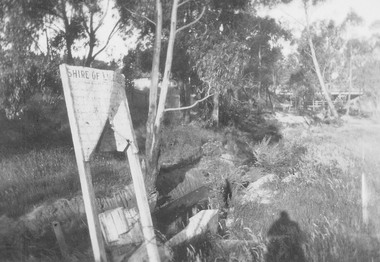
Photograph, Mullum Creek looking towards Warrandyte Rd. bridge. Showing Shire of Lillydale notice 1931
Written on backing sheet, "Mullum Creek looking towards Warrandyte Rd. bridge. Showing Shire of Lillydale notice". One photograph is dated 1931. -
 Ringwood and District Historical Society
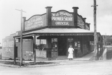
Photograph, Bill Blood - store opposite Greenwood St. in Bedford Rd. Ringwood c1924
Typed below photograph, "Bill Blood - store opposite Greenwood St. in Bedford Rd. Ringwood c1924. Was then outside the old railway level crossing". -
 Ringwood and District Historical Society
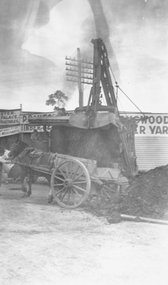
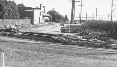
Photograph, Maroondah Highway Central, Ringwood. Roadworks on Maroondah Highway at corner Warrandyte Rd, 1935
Black and white photographs (1 large, 1 small) Typed below large photograph: "Roadworks on Maroondah Highway at corner Warrandyte Rd." Image shows horse and cart with scoop dumping soil into cart. -
 Tarnagulla History Archive
Photograph: Thomson & Comrie's Exchange Store, Tarnagulla, 1905
David Gordon Collection. Sepia photographic postcard depicting Thomson & Comrie's Exchange Store, in Commercial Rd, Tarnagulla, around 1905. commerce -
 Ringwood and District Historical Society
Photograph, Panfield Estate, Ringwood - 1960. Looking across to Mullum Rd. with Glen Cairn Ave. at right-angle to it. House at left is in Graeme Street, Ringwood
Written on backing sheet, "Panfield Estate 1960. Looking across to Mullum Rd. with Glen Cairn Ave. at right-angle to it. House at left is in Graeme St." -
 Ringwood and District Historical Society
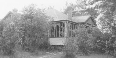
Photograph, Two photos of Dr. Hewitt's old home after alterations, 6 Warrandyte Rd. - August 1979
Written on back of photograph, "Dr. Hewitt's old home after alterations, 6 Warrandyte Rd." Same house as in item no. 166 but taken from a different angle. -
 Ringwood and District Historical Society
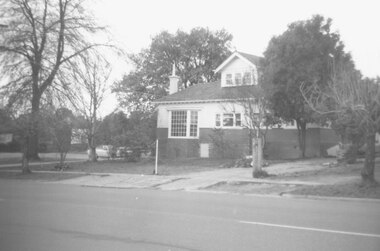
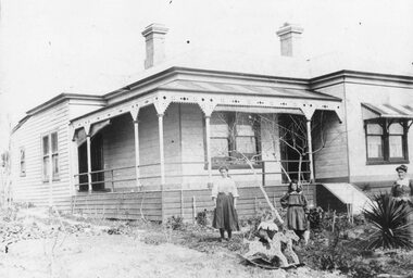
Photograph, 48 Warrandyte Rd, Ringwood. Home of Augustus Temple Miles
Black and white photograph of house and garden.Types below photograph, "48 Warrandyte Rd. Ringwood. Home of Augustus Temple Miles, First Mayor of Ringwood, 1924. Born Hobart 1880, died Ringwood 1962." -
 Ringwood and District Historical Society
Photograph, View of corner of Middlebrook Dr and Tortice Drive looking east towards Wonga Rd, North Ringwood. 1981
Written on back of photograph, "24/8/81. View of corner of (Blank) court and Tortice Drive looking east towards Wonga Rd. Thought to be Middlebrook Drive, not a court. -
 Ringwood and District Historical Society
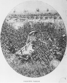
Photograph, Collecting Dahlias - Mr. Hill's Flower Farm - Mt. Dandenong Rd, Ringwood 1905
Black and white photograph (4 copies)Typed note at bottom of one photograph- "Mr. Hill's Flower Farm - Mt. Dandenong Rd. Miss Hill collecting dahlias. 1905." Typed note on back of separate photograph- "John Hill's flower farm 29/3/05, Mt Dandenong Rd, Ringwood East. Later Howship's flower farm, subdivided, name retained in street name. Miss Elvie Hill. -
 Ringwood and District Historical Society
Photograph, Hunt Home, 8 Bedford Rd Ringwood (undated)
Black and white photograph of weatherboard house with three children and a lady outside.Hunt Home written on front. The following is written on backing sheet, "Residence Walter Hunt, 8 Bedford Rd. Ringwood. Mrs. Hunt (Laureen Lynch), Tottie, Marion, Vera". -
 Ringwood and District Historical Society
Photograph, Continuation of Warrandyte Rd. to Bedford Road, Ringwood. Tibbs Licenced Grocers Store, 1967
Written on back of photograph, "Continuation of Warrandyte Rd. to Bedford Road, 1967. Tibbs Licenced Grocers". "New parking area - Pitt St. Ringwood". "Bryan Dales, photographer, Bayswater.." -
 Ringwood and District Historical Society
Photograph, Church of England relocation: About to cross bridge over Mullum Creek, Warrandyte Rd (undated)
Smaller photograph that appears to be the original from which this photograph was taken reads, "About to cross bridge over Mullum Creek, Warrandyte Rd. English Church" Appears to be Church of England. -
 Ringwood and District Historical Society
Photograph, Maroondah Highway Central, Ringwood. Whitehorse Rd. looking East from Adelaide St- 1918
Black and white photograph (3 copies- 2 large, 1 small postcard) Typed below one large photograph, "Whitehorse Rd. Looking east from Adelaide St. 1918". Image shows Falconer Grocer and Baker store on corner of Adelaide Street. -
 Ringwood and District Historical Society
Photograph, View from Herman Pump's orchard, Heathmont near Royal Avenue. Looking towards Bedford Rd. and Ringwood (undated)
Typed below photograph, "View from Herman Pump's orchard, Heathmont near Royal Avenue. Looking towards Bedford Rd. and Ringwood. Loughnans Hill in background to left of centre." -
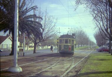
 Melbourne Tram Museum
Negative, Travis Jeffrey, 5/09/1960 12:00:00 AM
B&W negative of tram 466 in Somerville Rd, Footscray.Paper folder that contained the negative had "NR10A" written in red ink, "F6" written in pencil, "10A" written in blue ink, and date stamped 29 Nov 1959. On rear, dates stamped 26 Sep 1962 and 2 Sep 1962.trams, tramways, x1 class, footscray, somerville rd, tram 464 -
 Ringwood and District Historical Society
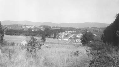
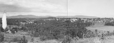
Photograph, Panoramic view of Ringwood taken from the home of Dr. Geoffrey A. Cook, Loughnan Rd., Ringwood. (No date)
Written on back of photograph, "Panoramic view of Ringwood taken from the home of Dr. Geoffrey A. Cook, Loughnan Rd., Ringwood. See booklet, 'Welcome to Ringwood' 1948 or 49' - H.J. Pearson Mayor". -
 Ringwood and District Historical Society
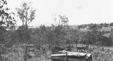
Photograph, Looking N.E. across Warrandyte Road 150 yards north of Oban Rd. at the houses around and SE of Parkwood High School 1981
Written on back of photograph, E607, N10, 19/6/1981. Looking N.E. across Warrandyte Road 150 yards north of Oban Rd. at the houses around and SE of Parkwood High School". -
 Melbourne Tram Museum
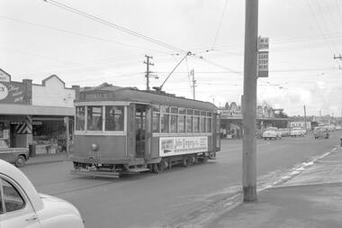
Negative - Set of 2, Travis Jeffrey, 10/06/1962 12:00:00 AM
Colour negative of tram 514 in Dandenong Road. Tram has destination Malvern - Burke Rd and Route No 5. Photo shows tram shunting. Note the newspaper box on the left hand side of the photograph. , Colour negative of tram 514 in Wattletree Road at Burke Rd terminus. Tram has destination City and Route No 5. Note thePaper folder that contained the negative had "NR77B" and date written as 10 Jun 62 in red ink., Paper folder that contained the negative had "NR76B" and date written as 10 Jun 62 in red ink.trams, tramways, w2 class, route 5, dandenong rd, wattle tree rd, malvern burke rd, tram 514 -
 Eltham District Historical Society Inc
Photograph - Aerial Photograph, Landata, Eltham, Main Road; Henry St to Bellevue Rd, Dec. 1945
Eltham, Main Road; Henry St to Bellevue Rd, and east along Luck St to present day Eltham East School Historic Aerial Imagery Source: Landata.vic.gov.au Aerial Photo Details: Project No :5 Project : MELBOURNE AND METROPOLITAN AREA PROJECT Run : 36 Frame : 60549 Date : 12/1945 Film Type : B/W Camera : EAG4 Flying Height : 10200 Scale : 6000 Film Number : 228 GDA2020 : 37°42'45"S, 145°08'59"E MGA2020 : 336903, 5824465 (55) Melways : 21 K4 (ed. 42)aerial photo, arthur street, bellevue road, bible street, diamond street, dudley street, elsa court, eltham, eltham east primary school, gahan house, henry street, livingstone road, luck street, main road, pryor street, neil webster collection -
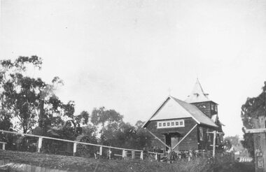 Ringwood and District Historical Society
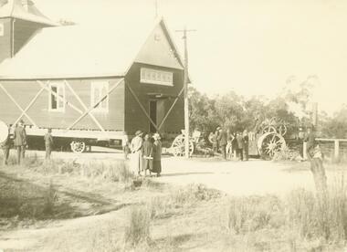
Photograph, Ringwood Church of England stuck on Warrandyte Rd. bridge over Mullum Creek whilst being removed - 1924
Black and white photograph of building, steam-roller in front.Written on backing sheet, "C of E stuck on W'dyte Rd. bridge over Mullum Ck. whilst being taken from C.r Main & Pratt Sts. to new site in Ringwood St. 1924" -
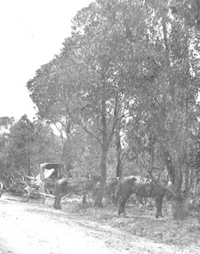 Ringwood and District Historical Society
Photograph, Roadmaking by McGiverns. Warrandyte Rd. just north of Mullum Creek. 1920s
Typed below photograph, "Roadmaking in Ringwood in the 1920s". Catalogue card reads, "Roadmaking by McGiverns. Warrandyte Rd. just north of Mullum Creek". Written on backing sheet, "McGiverns of Croydon in Andersons Creek Road". -
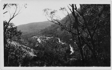 Halls Gap & Grampians Historical Society
Postcard - Sepia, C 1920s
The road winding up Stoney Creek Gorge with Elephant Hide, the rocky slope in the picture, on the left. Sections of the earlier 19th century bridal track, which was later widened to become a jinker track, can be seen above the new road.Postcard shows Mt Victory Rd unsealed Elephant's hide on leftPostcard Correspondence Address only Kodak Mt Vic Roadaccess routes, mt victory rd, roads -
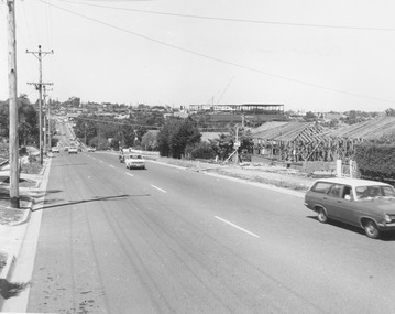 Ringwood and District Historical Society
Photograph, Warrandyte Rd. looking south towards Maroondah Hwy. Eastland second storey being built - c.1974
Typed below photograph, "Warrandyte Rd. looking south towards Maroondah Hwy. Eastland second storey being built - 1974?" Catalogue card states, "Frames to right are on site of 'Woodside' - Miss Huttons house". -
 Bendigo Historical Society Inc.
Document - COHN BROTHERS COLLECTION: SHARE TRANSFERS 1894
Cohn Brothers Share Transfer from August Nomens of Kinkora Rd Hawthorn to Charlotte Annie Nomens Kinkora Rd Hawthorn dated 27th April 1894. One penny Duty Stamp attached.bendigo, industry, cohn bros brewery, august nomens. charlotte annie nomens, kinkora rd hawthorn. -
 Ringwood and District Historical Society
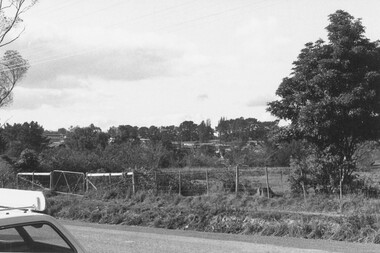
Photograph, Boundary photo. Heatherdale Rd. looking north east from Shibor Drive, Vermont. Jan. 1979
Written on back of photograph, "Jan. 79 - Boundary photo. Heatherdale Rd. looking north east. Taken at end of Shibor Dve (Vermont) (on high part end corner of school ground). One of 3 that join up." -
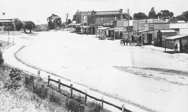 Ringwood and District Historical Society
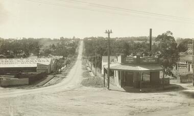
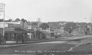
Photograph, Maroondah Highway Central, Ringwood. Whitehorse Rd. Ringwood looking west. 1918
Black and white photograph (3 copies- 2 large, 1 sepia postcard) Typed below one photograph: "Whitehorse Rd. Ringwood looking west - 1918" Image shows a variety of shops on left with a motor vehicle and a horse drawn cart out front. Station Master's house at top left.