Showing 354 items
matching valley view road
-
 Mt Dandenong & District Historical Society Inc.
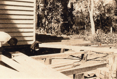
Photograph, Building Work at Kamanange, Kalorama
Close up view of unknown man working on an addition to the Robinson holiday house Kamanange.kamanange, robinson, kalorama -
 Mt Dandenong & District Historical Society Inc.
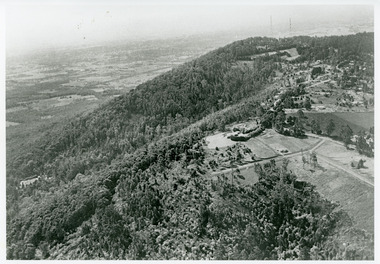
Photograph, View Towards Mt Dandenong 1961, 1961
Looking north towards Mt Dandenong 'City Lights' estate 1961. Viola Court in foreground, Ridge Road winding up the hill towards the Observatory.mount dandenong, ridge road, viola court, city lights estate -
 Mt Dandenong & District Historical Society Inc.
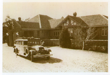
Photograph, Mount Dandenong Hotel with Blue Dandenongs Service Car
Front view of Mount Dandenong Hotel with Blue Dandenongs Service car in foreground. Travellers booked a seat for door to door service to the city. The hotel opened in 1935. The Olinda Garage was built by Sam Patterson to service 'Service Cars' but had no petrol.mount dandenong, mount dandenong hotel, service car, blue dandenongs service car, olinda garage, sam patterson -
 Mt Dandenong & District Historical Society Inc.
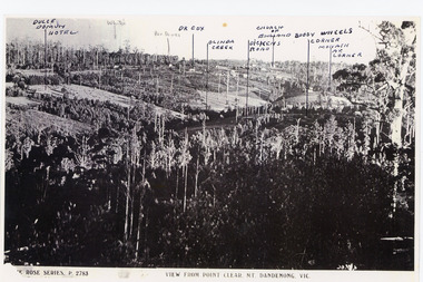
Photograph, View from Point Clear, Mt Dandenong, Vic
Rose Series Postcard number 2783Copy of Rose Series postcard #2783 showing view from Point Clear. This is taken from Ridge Road. The following indicators have been marked on the photograph L-R Dulce Domun Hotel, White's, Rev. Davies, Dr. Cox, Olinda Creek, Dickens Road, Church of England, Buggy Wheels Corner, Monash Ave. Corner.mount dandenong, ridge road, rose series, point clear -
 Mt Dandenong & District Historical Society Inc.
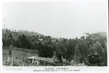
Photograph, Olinda, Victoria. Outlook to Ferntree Gully from Dulce Domun
Rose Series Postcard number 965Copy of Photo Series postcard #965 with view looking west to Mt Dandenong Road and Ridge Road. Looking across to where the Log Cabin (Kellys) would now be.mount dandenong, dulce domum, photo series -
 Mt Dandenong & District Historical Society Inc.
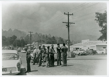
Photograph, Street view Mt Dandenong during 1962 bushfires, 1962
Taken during the 1962 bushfires. View of Mount Dandenong shops opposite the Hotel with garage to the right. 8 men in foreground with smoke clearly visible.mount dandenong, mt dandenong road, bushfire -
 Mt Dandenong & District Historical Society Inc.
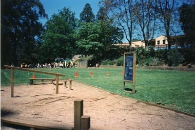
Photograph, Mount Dandenong Primary School 1997, 1997
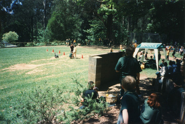
The Exersite equipment allowed for student and public use. The equipment was removed when the oval was refurbished in 2004.View of 'Exersite' equipment at bottom corner of school oval with students participating in Sports day in the background. 1997.mount dandenong, mt dandenong school, exersite -
 Mt Dandenong & District Historical Society Inc.
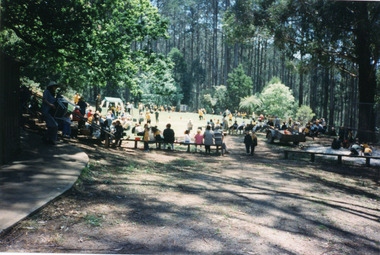
Photograph, Mount Dandenong Primary School 1997, 1997
1997 was the school's centenary year. The first Mt Dandenong State School opened in a shed on the property of William Ferguson on the corner of Blythe and Old Coach Roads. The first teacher was Miss Ethel Gruber who opened the school on May 11th, 1897. It wasn’t until 1901 that the school shifted over the road into an old school building that was moved up to the new site from Ringwood. All the buildings were demolished to make way for a new school that opened in 1991. View of Sports Day November 1997 with parents watching and children participating.mount dandenong, mt dandenong school, centenary -
 Mt Dandenong & District Historical Society Inc.
Photograph, Mount Dandenong Primary School 1997, 1997
View of Sports Day looking down over the oval with the 'rebound Wall' in the foreground 1997.mount dandenong, mt dandenong school -
 Mt Dandenong & District Historical Society Inc.
Photograph, A View Over Mountain Grange 1921, 1921
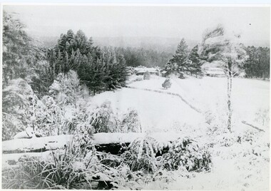
A view of Mountain Grange Homestead built by Thomas Hand with buildings and ground covered in snow. The photograph has historical information on the back handwritten by John Lundy-Clarke in 1976.1921 A view over “Mountain Grange” from the side of Mt Kalorama above where Grange Road is now. On the left of the homestead is the avenue of pine trees under which the annual Sunday School picnic was held. On the right is the giant pine that still stands (1976) and the great barn. The separate kitchen of the homestead can be clearly seen. mountain grange, snow, john lundy-clarke, thomas hand -
 Mt Dandenong & District Historical Society Inc.
Photograph, View From George Barber's Home On Olinda Creek Towards The Gap. c1905, 1905
Black and white photograph showing view towards The Gap (Jeeves Saddle), (Five Ways) taken c1905. Detailed inscription on back handwritten by John Lundy-Clarke in 1973.1905 (c ) view from Barber’s home on Olinda Creek, towards the Gap, then known as Jeeves Saddle. Barber’s stable in foreground. “Shiloah” Complex centre right. Tait’s house in gully just left of centre. Logan’s house can just be seen under magnifier at top of same gully near line of Barber’s Road. “Kalorama” just below lowest portion of Gap skyline with Barnes (Paynters) house “Iona” to its left. Photo copied 1973. JLC. george barber, shiloah, kalorama, iona, olinda creek, the gap, jeeves saddle, tait, paynter, barber -
 Mt Dandenong & District Historical Society Inc.
Photograph, 1908 View of Kalorama Gap From the Main Road, 1908
View of the Kalorama Gap from main Road (now Ridge Road), looking across Walker's raspberry patch with Mountjoy coaching stables on the LHS and Mountjoy Guest House in centre. Price's house and shop on the RHS.mountjoy, walker, raspberry, coach, stables -
 Mt Dandenong & District Historical Society Inc.
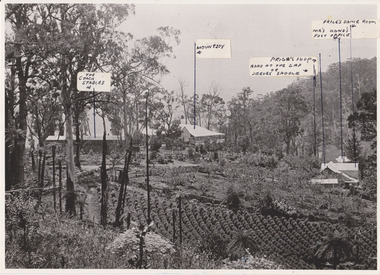
Photograph, 1908 View of the Kalorama Gap from Main Road With Labelling, 1908
Photograph with labels attached to front identifying buildings. View of the Kalorama Gap from main Road (now Ridge Road), looking across Walker's raspberry patch with Mountjoy coaching stables on the LHS and Mountjoy Guest House in centre. Price's house and shop on the RHS. This photograph has a detailed inscription on the back handwritten by John Lundy-Clarke in 1974.1908 View of the Kalorama Gap from main Road – now Ridge Road above Lot 2 of the Village Settlement. Looking across Walker’s raspberry patch with “Mountjoy” coaching stables on left. “Mountjoy” in centre. Prices house and shop on right with Hands “Beulah Tearooms” above Prices roof. On hillside beyond Hand’s is the slope now taken up by Kalorama Terrace. Walker’s well, then newly dug is in lower right hand corner below the tree fern head. Mt Kalorama is the hill top right. Track leaving Main Road left is Walker’s entrance drive.kalorama, kalorama gap, walker, beulah tea rooms, price, hand, mountjoy, mt kalorama -
 Mt Dandenong & District Historical Society Inc.
Photograph, View from 'Forest Edge', 1973
Photograph taken in 1973 from the property 'Forest Edge', the home of early settler George Barber. This photograph has a detailed inscription on the back handwritten by John Lundy-Clarke in 1973.Taken November 1973 by JLC. View looking from “Forest Edge” George Barber’s old home towards Price’s Lot 18. Gap on right skyline. Broadways house centre on Lot 18. Lot 25 in foreground recently cleared by Merchant Builders. Kia Ora site centre left. forest edge, george barber, price, kia ora -
 Mt Dandenong & District Historical Society Inc.
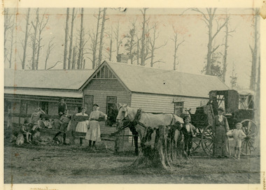
Photograph, 'Callum House' - Bill Farndon's Guest House 1911, 1911
Front view of Callum House located on the corner of Falls and Farndons Roads. Built by Bill Farndon. In the background are trees killed by bushfires in 1897. There is a horse and buggy in the foreground. Figures standing have been identified as (from LHS) Jim Clarke, Len Farndon, Jack Clarke, Essie Farndon, Rhoda farndon, Doug Farndon, Mrs Farndon. Driver is Bill Campbell. This photograph has a detailed inscription on the back handwritten by John Lundy-Clarke in 1974.1911 “Callum House” Farndon’s guest house corner of Fall’s and Farndon’s Roads. Later “Bonvenu” and again “The Oaks”. Showing the trees killed by bushfires in 1897. Figures standing are from left – Jim Clarke, Len Farndon, Jack Clarke, Essie Farndon, Rhoda Farndon, Doug Farndon, Mrs. Farndon. Bill Campbell driving.callum house, benvenu, the oaks, essie farndon, bill farndon, rhoda farndon, bill campbell, jim clarke, jack clarke, doug farndon -
 Mt Dandenong & District Historical Society Inc.
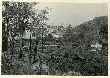
Photograph, Harry Walker's Home in Village Settlement 1908, c1908
View of Harry Walker's home taken from waht is now known as Ridge Road, Kalorama. Raspberry crops are in the foreground. This photograph has a detailed inscription on the back handwritten by John Lundy-Clarke in 1974.1908 view of H Walker’s home on Village Settle Lot 2 Section 1. Looking from what is now Ridge Road through the trees on Vil. Set Lot 18 to Barber’s house now known as “Forest Edge” on Vil Set Lot 25 down close to the Olinda Creek on Barbers Road. The Estate Agent’s modern office is on the edge of the patch of raspberries at the lower left as the C.R.B. Mt Dandenong Rd passes just behind Walker’s house crossing the picture behind the raspberries.walker, raspberry crop, forest edge, barber -
 Mt Dandenong & District Historical Society Inc.
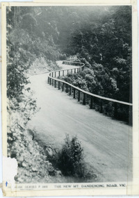
Photograph, The New Mt Dandenong Road, Vic
Copy of Rose Series postcard #385 showing the new Mt Dandenong Tourist Road with wooden railing fence on low side of road. Surface not yet made. This photograph has a detailed inscription on the back handwritten by John Lundy-Clarke in 1974.View downhill from the Windy Bend showing the site of the 1972 landslide. In this picture the road is running along the top edge of the wall 900’ thick of Kalorama Docite that plunges thousands of feet deep down into the earth below the Ranges and extends to Fern Tree Gully. It was once a horizontal terrace nearly ten miles square and tipped over to the left when the mountain subsided into its volcanic cauldron.mt dandenong road, rose series, windy bend, landslide -
 Mt Dandenong & District Historical Society Inc.
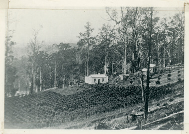
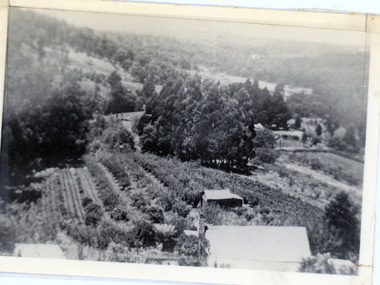
Photograph, View of valley looking south over 'Kalorama' towards falls, 1908
View taken 1908 looking south over 'Kalorama', home of Ellis and Eliza Jeeves, across the valley towards the falls.This photograph has a detailed inscription on the back handwritten by John Lundy-Clarke in 1974.View taken 1908 of valley looking south over “Kalorama” towards the falls. House right of “Kalorama” was Paynter’s “Iona” on Lot 29. Faintly below line of Barber’s Road above “Kalorama” is Logan’s house on Lot 28. House against orchard was Pimm’s later Prince’s Lot 19. Big trees on right were on Price’s Lot 18 and were between Tosari Rd and Rosemont Cres. It was FROM one of these being cut up in 1931 that the round length log weighing ½ a ton got away from the splitters and raced down the hill in bounces, one of which cleared Barber’s Rd and Logan’s house in leaping from the fence line above the road.kalorama, paynter, iona, barbers road, ellis jeeves -
 Mt Dandenong & District Historical Society Inc.
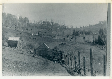
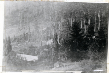
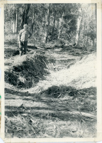
Photograph, Pit Silo 1974 view, 1974
Photograph taken in 1974 showing John Lundy-Clarke standing beside the pit silo he dug in he 1920s on Dunbar's Lot 20 of the Village Settlement. The pit silo was to hold cut maize to turn into silage for a food supply for the cows in the winter.A 1974 view of the pit silo and its maker at Lot 20 of the Village Settlement (Dunbar’s lot) The trees in the background cover the landslide of 1891-1934.pit silo, john lundy-clarke -
 Mt Dandenong & District Historical Society Inc.
Photograph, 1913 View Over Logan's House in Village Settlement, 1913
Photograph taken in 1913 from Barbers Road showing the view down the valley. Roof in foreground is house on Bob Logan's Lot 28 in the Village Settlement. This photograph has a detailed inscription on the back handwritten by John Lundy-Clarke in 1974.1913 view over Logan’s house on Village Settlement Lot 28 taken from Barber’s Road. This is the house that the runaway log leaped over in 1930 to land far down the orchard row beyond the house. “Shiloah” is centre partly behind the clump of trees and the paddocks of Child and Richardsons pioneer selections are in the background. Link Road is centre right.logan, bob logan, robert logan, barbers road, shiloah, child, richardson, link road -
 Mt Dandenong & District Historical Society Inc.
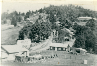
Photograph, Kalorama Gap in 1927, 1927
View of the Kalorama Gap (FiveWays) in 1927. Buildings shown are Jeeves' Garage, FiveWays Cafe, Nicholl's Store, Mountjoy. CRB Main Road, Ridge Road, Old Coach Road and barber's Road also visible. This photograph has a detailed inscription on the back handwritten by John Lundy-Clarke in 1974. The Kalorama Gap in 1927. Showing Jeeves Garage Fiveways Cafe Nicholls Store 'Mountjoy' C.R.B Main Rd Center Ridge Road Right of Center Old Coach Road lower right corner behind shed Barber's Road going left through clump of trees in center kalorama gap, kalorama, fiveways, fiveways cafe, jeeves, jeeves garage, garage, nicholls store, mountjoy, barbers road, old coach road, ridge road, main road, crb road -
 Mt Dandenong & District Historical Society Inc.
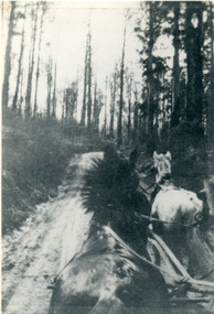
Photograph, View From Seat of Jeeves Coach, c1921
View the driver would have from horse drawn coach. CRB (Main) Road between Wombat Road and Falls Road. c1921. This photograph has a detailed inscription on the back handwritten by John Lundy-Clarke in 1974.View from seat of Jeeves Coach over horses while being driven along the new CRB road between Wombat Road and Falls Rd 1921.wombat road, falls road, crb road, jeeves coach, horse -
 Mt Dandenong & District Historical Society Inc.
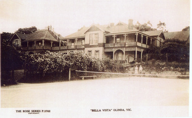
Photograph, "Bella Vista" Olinda, c1940
Copy of Rose Series Postcard number 3762Copy of Rose Series Postcard #3762 showing Bella Vista Guest House at Olinda. This image is c1940s and shows the tennis court in the foreground. Bella Vista was built by Edmund Boulter in 1903. It comprised two large buildings with a walkway linking the balconies at second storey level. Views of Westernport and Port Phillip Bays could be seen from the rooftop lookout. Bella Vista was reputed to accommodate eighty guests. The Guest House operated until 1956, when it burned down.bella vista, guest house, tennis, boulter, rose series -
 Mt Dandenong & District Historical Society Inc.
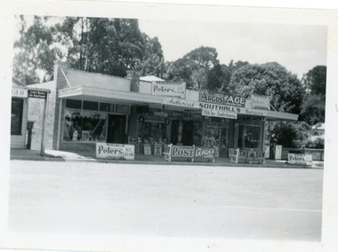
Photograph, Southall's Newsagency Olinda, late 1920s
Small photograph from the Olinda township showing view of Southall's Newsagency with milkbar and confectionary. There are many old advertising signs clearly visible. The road is not yet made so this would place the date around the late 1920s.southalls, olinda, newsagency, milkbar -
 Mt Dandenong & District Historical Society Inc.
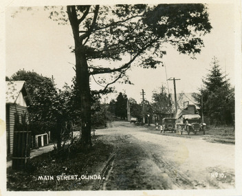
Photograph, Main Street, Olinda, c1930s
Number 10 in commercial seriesSmall photograph, number 10 in Olinda series, showing Main Street Olinda. View is looking NW from Olinda Monbulk Road towards Range Road. Left hand building is old Olinda Post Office. Ice truck is outside shops in distance and a delivery truck with tarp can be seen. c1930solinda, post office, truck -
 Mt Dandenong & District Historical Society Inc.
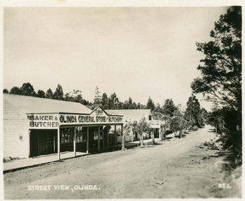
Photograph, Street View, Olinda, late 1930s
Number 1 in commercial series.Small photograph, number 1 in Olinda series, showing a view of the Main Street of Olinda late 1930s. V.J. Boulter's Olinda General Store with butcher and bakery in foreground. Road not yet made.boulter, v.j. boulter, general store, butcher, bakery, olinda -
 Mt Dandenong & District Historical Society Inc.
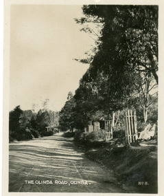
Photograph, The Olinda Road, Olinda, late 1930s
Number 8 in commercial series.Small photograph, number 8 in Olinda series, showing the road view looking towards sassafras. Note wooden picket tree guards and two ladies sitting on seat on RHS. Road not yet made. Late 1930s.olinda, road -
 Mt Dandenong & District Historical Society Inc.
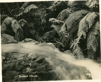
Photograph, Olinda Falls, late 1930s
Number 6 in commercial series.Small photograph, number 6 in Olinda series, showing view of Olinda Falls with ferns in background. Late 1930s.olinda falls, olinda, ferns -
 Southern Sherbrooke Historical Society Inc.
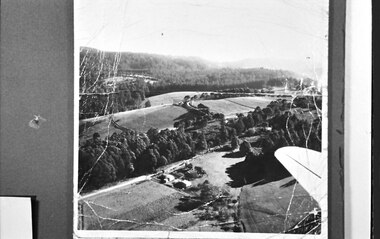
Photograph, Aerial view of Cotswold Valley
Aerial view of Cotswold Valley, Menzies Creek. B&W photos taken from light plane. Paddocks and treed areas are visible. Two houses are in the centre of the photo, presumably the Breen farmhouse on Jacksons Hill Road. The tip of the plane's left wing is also visible. -
 Southern Sherbrooke Historical Society Inc.
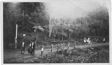
Photograph - Belgrave, Beauty Bend
B&W photo of a scene in Belgrave, taken Easter 1922 presumably by Miss Field. The view is of Beauty Bend on the Monbulk Road where it crosses a small gully. Two men and a woman are standing on the near side of the fenced-off gully, another group people, perhaps two men and four women and girls, are sitting and standing on the far side of the gully, and a further two people are at the right of the photo. There are trees and tree ferns in the background and two signs are visible, attached to trees and possibly pertaining to a guesthouse further up the hill and accessible by a path which is just visible. On the back of the photo 'Belgrave Easter 1922' is written in pen.