Showing 2386 items
matching annotations%20on%20the%20epistles%20vol%202
-
 Kew Historical Society Inc
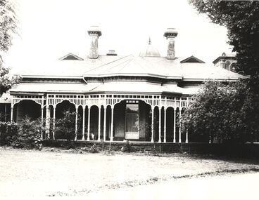
Photograph - 'Ellesmere', Princess Street (Kew), c.1965
Ellesmere was a mansion in Princess Street, Kew (now demolished). This view of the house is of the front veranda. At a later stage it was to operate as a hostel for girls run by the Presbyterian Church. Annotation on reverse: "Ellesmere. Princess St. Now Presbyterian Girls Hostel". 170x220mm. ellesmere -- princess street -- kew (vic), houses -- princess street -- kew (vic) -
 Kew Historical Society Inc
Album - Construction of the electric tram line in Cotham Road, Kew, E.J. Dower, 1913
E.J. Dower was born and raised in Olinda. He later moved with his parents to Surrey Hills. He worked as an adult as a clerk in the city office of the Metropolitan Gas Company, and in his role as a 'collector', was able to photograph scenes including the construction of tram and train lines and associated buildings in Kew, Hawthorn, Camberwell and Surrey Hills. Later he established a real estate agency with his brother - the E.J. Dower Real Estate Agency, Dandenong Office.The album and its photographs are an historically significant record of the development of transport infrastructure which was used to connect Victorians in the first two decades of the twentieth century. This development resulted from increases in population and the consequent extension of Melbourne's suburbs. The photographs in the album, as well as Dower's single photos mounted on card, detail the labour of workers and the tools and machinery used to create and extend Melbourne's tram and train networks in the years preceding and during World War 1.Album of six annotated photos of construction of the St Kilda to Kew electric tram line, taken in Cotham Road, Kew, by the amateur photographer, Edgar James Dower, in 1913. The album contains images detailing the preparation for the laying of the tracks plus work on laying the line. The album, together with other phots by E.J. Dower has been made available by the owners for the Kew Historical Society to digitise and publish online and in print.Annotations by the photographer, often added over time, on the reverse of each photo in the album.theme -- connecting victorians by transport and communications, theme -- travelling by tram, photographers -- edgar james dower, cotham road -- kew (vic.) -
 Kew Historical Society Inc
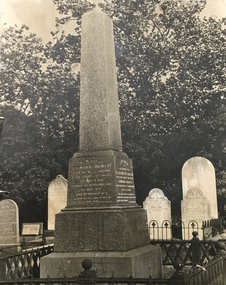
Photograph - Henty Grave, Boroondara General (Kew) Cemetery, c.1976
The Henty family, the first European settlers in the State of Victoria, owned a number of houses in Kew and many members of the family are buried in the Boroondara General (Kew) Cemetery, including Edward Henty, the first European settler in Victoria.Monumental grave marker for Edward Henty and his family in the Boroondara General Cemetery. Annotation on reverse: "Reg No-KH-135. Donated by Mrs Nita Green, 1979nita green, henty family, boroondara general cemetery, edward henty -
 Kew Historical Society Inc
Photograph - Kew Junction, Herald & Weekly Times, 1962
This is an aerial oblique image looking north. It shows Kew Junction before construction of VicRoads (Country Roads Board), Murphy's (Leo's) supermarket, and office towers. It also shows a building on the land now known as the Raoul Wallenberg Reserve, the Kew Municipal Offices in Walpole Street, and St Paul's School for the Blind in Fernhurst Grove, and Kew Bowling Club in Wellington Street.An aerial photograph of Kew Junction, showing the intersection of High Street South, Studley Park Road, Princess Street, High Street and Denmark Street. A number of buildings, now demolished can be identified in the photo, including Jellis’ Bakeries on the corner of Princess Street and Studley Park Road." Annotation on reverse: "Kew Historical Society from Mr L. H. Chinner".kew junction, aerial photograph (kew), oblique aerial, st paul's school for the blind, kew municipal offices, high street kew, studley park road, kew war memorial, kew post office, kew police station, kew court house, high street south, kew, wellington street kew, denmark street kew -
 Kew Historical Society Inc
Photograph - Flooding of the Yarra Valley at Kew East, 1974
Flooding of the Yarra Valley, including that section of the Yarra bordering Kew and Kew East in the north and west of the municipality, was a regular occurrence. Extreme flood events of the Yarra River are recorded to have occurred in 1891, 1901, 1916, 1923 and 1934. The Municipality of Kew's response to these floods was to enact planning decisions restricting residential development in flood prone areas following the floods of 1916, 1921 and 1934. While floods continued after the development of the Upper Yarra Reservoir (construction 1948-57), the regularity and extent of these inundations diminished. During the nineteenth century, the land abutting the south side of the Yarra in Kew was devoted to dairy farming. In the twentieth century, before and after the construction of the Eastern Freeway, much of this low-lying area was used as golf courses and public parks.Late example of the capacity of the Yarra Valley at Kew to flood, even though drainage works and the Upper Yarra Reservoir had reduced their regularity.Original black and white print photograph of Hay's Paddock under floodwater on 16 May 1974. The vantage point of the photographer is Keystone Crescent looking east. Flooding was caused by overflowing water in Glass' Creek and the River Yarra. Annotation verso: "Keystone Cr looking east / 16 May 1974 11.50am"hays paddock, floods, yarra river, glass' creek -
 Kew Historical Society Inc
Photograph - Flooding of the Yarra Valley at Kew East, 1974
Flooding of the Yarra Valley, including that section of the Yarra bordering Kew and Kew East in the north and west of the municipality, was a regular occurrence. Extreme flood events of the Yarra River are recorded to have occurred in 1891, 1901, 1916, 1923 and 1934. The Municipality of Kew's response to these floods was to enact planning decisions restricting residential development in flood prone areas following the floods of 1916, 1921 and 1934. While floods continued after the development of the Upper Yarra Reservoir (construction 1948-57), the regularity and extent of these inundations diminished. During the nineteenth century, the land abutting the south side of the Yarra in Kew was devoted to dairy farming. In the twentieth century, before and after the construction of the Eastern Freeway, much of this low-lying area was used as golf courses and public parks.Late example of the capacity of the Yarra Valley at Kew to flood, even though drainage works and the Upper Yarra Reservoir had reduced their regularity.Original black and white print photograph of the low-lying land at East Kew under floodwater on 16 May 1974. The vantage point of the photographer is at Willsmere Road. The road itself is underwater.Annotation verso: "Willsmere Rd / Same as No.7 / 16 May 1974 11.15am"floods, yarra river, willsmere road -
 Melbourne Legacy
Document - Document, minutes, National Conference 1998 Minutes of the Planning Panel, 1998
Minutes of the last planning meeting (22 September 1998) before the 1998 National Conference took place on 2-4 October 1998, which demonstrates the degree of preparedness for the event. The included Agenda for the follow up meeting after the conference seemed to be simply to confirm these minutes, consider matters arising, and then 'hopefully' adjourn for lunch.An indication of the work involved in planning the 75th Anniversary Conference.Printed sheets, black on white.Various annotations in blue and black biro, with the name 'L/Simonson' on the Agenda page.conference, 75th anniversary -
 Bendigo Historical Society Inc.
Document - MERLE HALL COLLECTION: BENDIGO PERFORMANCE OF THE AUSTRALIAN DANCE THEATRE
Bendigo Performance of the Australian Dance Theatre - Press Release and various correspondence relating to the Bendigo performance (from the Victorian Arts Council ). Performance at the Kangaroo Flat Technical School Auditorium. June 1980. Attached card with various handwritten annotations . -
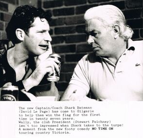 Bendigo Historical Society Inc.
Photograph - MERLE HALL COLLECTION: PHOTOGRAPH OF DAVID PAGE AND STEWART FAICHNEY OF FOOTY COMEDY ''NO TIME ON''
B&W photograph of David Page and Stewart Faichney of footy comedy ''No Time On''. Annotation describing moment from the new footy comedy touring country Victoria. Photo of two performers talking to one another - with VB can in hand. -
 Bendigo Historical Society Inc.
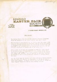
Document - BENDIGO EASTER FAIR COLLECTION: NEWS RELEASE
Letterhead Bendigo Easter Fair Society, 27 Queen Street, Bendigo, 3550. Secretary H.A. Sutton, PO box 202, Bendigo. An updated Souvenir Programme has been updated and 3000 copies are now available. It describes how a French Carnival inspired the Popular Girl Competition.bendigo, bendigo easter fair, news release -
 Bendigo Historical Society Inc.
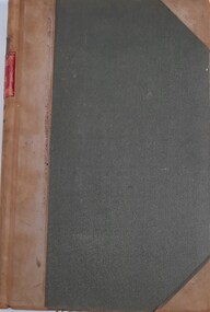
Document - RESIDENCE AREAS REGISTER: VOLUME 22, 1932 - 1935
Document: RESIDENCE AREAS REGISTER - Volume 2. Green hardcover register with buff spine and corners. 202 pages listing residence areas, Bendigo district, Sandhurst division 3 May 1932 to 6 November 1935. Index contained in separate book. Correspondence enclosed inside book.bendigo, sandhurst, land sales, residence areas -
National Wool Museum
Book, Australian Wool Realization Commission Table of limits season 1948-1949
"Australian Wool Realization Commission: Table of limits season 1948-1949", includes annotationswool sales wool brokering woolclassing, c. of a. - australian wool realization commission, wool sales, wool brokering, woolclassing -
 Bendigo Historical Society Inc.
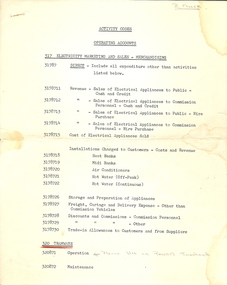
Document - BASIL MILLER COLLECTION: TRAMS - OPERATING ACCOUNTS
Three (3) typewritten pages listing activity by codes for operating accounts, 317 Electricity marketing and Sales - Merchandising with handwritten annotations. Responsibility codes and labour Gang Codes. B. Miller written in pencil on top right corner of front page.person, individual, basil miller -
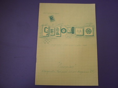 Wangaratta High School
WTS Yearbook -Geronimo, 1985
Yellow grid ruled yearbook with green drawing depicting a number of individual drawings in the shape off letters which make up the word GERONIMO with annotations. Along the bottom of the page is text reading "Geronimo" Wangaratta Technical School Magazine '85GERONIMO "Geronimo" Wangaratta Technical School Magazine '85 -
Kew Historical Society Inc
Plan, Gwen McWilliam, Annotated Plan of the City of Camberwell, 1993
Gwen Barton McWilliam (nee: Nelson), OAM, BA (1933- ). Gwen McWilliam is well known as an authority on the history of Boroondara and the author of a large number of books and pamphlets about the City. She was awarded the medal of the Order of Australia in 2001 ‘for service to the community of Hawthorn and district, particularly through the research, documentation and publication of its history.’ Plan of Camberwell, Canterbury, Balwyn and Surrey Hills, forming part of a larger plan of the City of Boroondara, including annotations by the historian Gwen McWilliam, identifying significant landholdings, subdivisions and key dates. The plan was donated to the Kew Historical Society by Ms McWilliam. city of boroondara, subdivisions - camberwell, subdivisions - balwyn, subdivisions - surrey hills, subdivisions - canterbury, gwen mcwilliam -
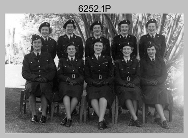 Bendigo Military Museum
Photograph - WRAAC Personnel posted to the Army Headquarters Survey Regiment, Fortuna Bendigo, c1950s – 1960s
This is a collection of seven photographs of Women’s Royal Australian Army Corps (WRAAC) personnel posted to the Army Headquarters Survey Regiment, Fortuna, Bendigo circa 1957 to 1964. After the disbandment of the Australian Women's Army Service (AWAS) in 1947 there was only one or two of civilian women in administrative positions at Fortuna. In February 1957 female positions from the disbanded Southern Command Field Survey Section in Melbourne were transferred to newly established positions at the Army Headquarters Survey Regiment, Bendigo. They were accommodated at the newly acquired ‘Turriff’ mansion in Carpenter Street, Bendigo. Their first Officer Commanding (OC) was CAPT Beryl Perry from 1957 to September 1960. Her replacement as OC was CAPT Carol Castor who served in several positions up to June 1967. The main areas of employment in these early days were in administrative positions, draughting in and retouching in Lithographic Squadron. WO2 MA McLaren was the female to reach the rank of WO2 as a Cartographic Squadron section commander in June 1961. WO1 Marj Knight served at Fortuna from 1959 to 1978 was the first female to reach the rank of WO1. WO1 Knight served in the senior Squadron Sergeant-Major and Technical Warrant Officer positions of Cartographic Squadron. She was also the first female PMC of the Army Survey Regiment SGT’s Mess. The WRAAC uniform seen in this collection was replaced in 1979. As the Australian Army implemented the disbandment of the WRAAC as a separate corps in 1980, WRAAC personnel posted to Royal Australian Survey Corps units were integrated into RA Svy.This is a collection of seven photographs of Women’s Royal Australian Army Corps (WRAAC) personnel posted to the Army Headquarters Survey Regiment, Fortuna Bendigo circa 1957 to 1964. The photographs were printed on photographic paper and are part of the Army Survey Regiment’s Collection. The photographs were scanned at 300 dpi. .1) - Photo, black & white, c1957. Back row – unidentified personnel, Front row – centre: CAPT Beryl Perry, unidentified personnel. .2) - Photo, black & white, c1958. Back row – unidentified personnel, Front row L to R: unidentified, SGT MA McLaren, CAPT Beryl Perry, unidentified (x2). .3) - Photo, black & white c1959. Back row – unidentified personnel, Front row L to R: unidentified (x2), SGT MA McLaren, CAPT Carol Castor, unidentified (x3). .4) - Photo, black & white, October 1961. L to R: WO2 MA McLaren, PTE CA Brown, CAPT Carol Castor, PTE HS Pasley, PTE BJ Madex, CPL Marj Knight. .5) - Photo, black & white, October 1961. L to R: PTE BJ Madex, PTE HS Pasley, PTE CA Brown, WO2 MA McLaren, CPL Marj Knight. .6) - Photo, black & white, August 1963. Back row – L to R: PTE Hollingsworth, PTE GM Hill, PTE PE Sykes, PTE Nola Strawbridge, PTE Jan Cruickshank, PTE Margaret Taylor, PTE Prescott, PTE RR Hutton, PTE BJ Madex, PTE BM Fuhrmann, PTE Cockburn. Front row – L to R: PTE NA Falot, LCPL JA Hurst, SGT Marj Knight, CAPT Carol Caster, CPL Jennifer Murray, LCPL A Burrows, unidentified. .7) - Photo, black & white, 1964. Back row – L to R: PTE Dianne Fowler, PTE Leslie Mortimer, PTE Marlene Penglase, PTE Marg Cooper, PTE Irene Rankins, PTE Elaine Veith, PTE Lyn Ireland, PTE Marg Murphy, PTE Nola Downes, PTE Joan Lawler, PTE Henni Schunck. Front row – L to R: PTE Loretta Hall, LCPL Jo McNamara, SGT Marj Knight, CAPT Carol Caster, CPL Nola Strawbridge, PTE Mary McHugh, PTE Kalen Sargent..1P to .3P, .7P - no annotation, .4P to .6P - Personnel (surnames, no rank) annotated on back.royal australian survey corps, rasvy, army survey regiment, army svy regt, fortuna, asr, wraac -
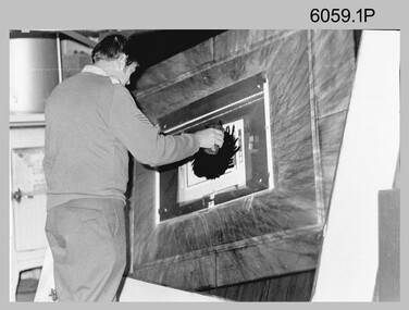 Bendigo Military Museum
Photograph - Photographic Technicians performing tasks at the Army Survey Regiment, c1960s, c1970s
These five photographs were most likely taken in the 1970s in Lithographic Squadron at the Army Survey Regiment, Fortuna, Bendigo. Photos .1P to .3P are annotated with the name of the technicians written on the back. Although Photo .4P is not annotated the technician is positively identified. In these five photos the technician is applying a UV-sensitive pigmented dye emulating one of the print colours to a white opaque polyester sheet mounted on a rotating table in a whirler. The coated sheet was dried before placement in a vacuum light frame beneath a stud registered map negative. They were then exposed to a carbon arc lamp. If there was more than one negative – typical for a type impression or 1st proof, the process was repeated for the other negatives of that print colour. There was a single exposure for composite negatives which was typical for the 2nd and final proof - the pre-press proof. The sheet was removed and washed with water and dried leaving the exposed colour impression. The technician repeated this process using process or spot dyes for remaining publication colours. Type impressions were a combination of the map grid and the topographic features in their correct print colours, forming a base for the cartographer to accurately position map names and symbols on a clear film overlay. The pre-press proof was a cost-effective way of producing a one-off visual copy of the map or chart product. It enabled cartographers to perform a quality inspection and correct any faults before publication. The pre-press proof was deemed authoritative before its release to Print Troop for bulk printing and distribution.This is a set of photographs of lithographic technicians preparing map proofs at the Army Survey Regiment, Bendigo c1960s c1970s. The photographs were printed on photographic paper and are part of the Army Survey Regiment’s Collection. The photographs were scanned at 300 dpi. .1) - Photo, black & white, c1970s, SGT Graham Jeffers, Lithographic Squadron .2) - Photo, black & white, c1970s, SGT Ken Slater Lithographic Squadron .3) - Photo, black & white, c1970s, Ian ‘Loft’ Turner, Lithographic Squadron .4) - Photo, black & white, c1970s, Gary Kerr, Lithographic Squadron .5) - Photo, black & white, c1960s, unidentified, Lithographic Squadron.1 to .3 – personnel names (less rank) annotated on back. .4 to .5P – no annotationroyal australian survey corps, rasvy, army survey regiment, army svy regt, fortuna, asr, litho -
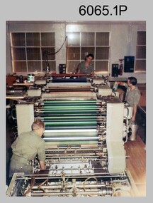 Bendigo Military Museum
Photograph - Ultra-MAN-III Printing Presses operating at the Army Survey Regiment, c1970s to c1980s
These ten photographs of the Ultra-MAN-III Printing Presses were probably taken circa 1970s to 1980s in Lithographic Squadron at the Army Survey Regiment, Fortuna, Bendigo. Although most photos are not annotated except for photos .1, .3P, .6P; most personnel are positively identified. The two Ultra-MAN-III Printing Presses were made in Germany at a standard map size format and introduced in June 1962 as a two-colour offset press with improved safety features. With an upgrade to a third colour deck in 1968, productivity greatly improved as the two presses could print a five colour standard topographic map in two passes, rather than the three passes before their upgrade. They were replaced with a single Heidelberg Speedmaster 102 five colour Printing Press in 1990. c1970s to c1980s.This is a set of photographs of the Ultra-MAN-III Printing Press operational at the Army Survey Regiment, Bendigo c1970s to c1980s. The photographs were printed on photographic paper and are part of the Army Survey Regiment’s Collection. The photographs were scanned at 300 dpi. .1) - Photo, colour, c1970s, L to R: Morgan, Mulqueen, Cook, Lithographic Squadron .2) - Photo, black & white, c1980s, unidentified, Lithographic Squadron .3) - Photo, black & white, c1980s, Ken Slater, Lithographic Squadron .4) - Photo, black & white, c1980s, L to R: Kim Reynolds, Terry Winzar, Lithographic Squadron .5) - Photo, black & white, c1980s, Lithographic Squadron .6) - Photo, black & white, c1980s, L to R: Steve Egan, unidentified, Jim Cook, Lithographic Squadron .7) - Photo, black & white, c1980s, Kim Reynolds, Lithographic Squadron .8) - Photo, black & white, c1980s, Roy Hicks, Lithographic Squadron .9) - Photo, black & white, c1980s, Lithographic Squadron .10) - Photo, black & white, c1980s, Colin Yeats, Lithographic Squadron.1, .3P, .6P – personnel annotated 2P, .4P to .5P, .76P to .10P – no annotation royal australian survey corps, rasvy, army survey regiment, army svy regt, fortuna, asr, printing, litho -
 Bendigo Military Museum
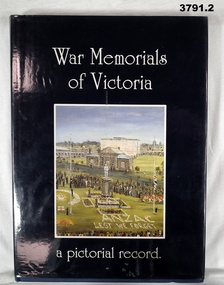
Book - BOOK, MEMORIALS, War Memorials of Victoria
War Memorials of Victoria, a pictorial record.Hard, navy blue buckram cover with gold print on spine. Paper with plastic dust cover. White print on front & spine. Dark blue background with front illustration, colour photo of a painting depicting The Portland War Memorial scene. 240 cut, plain, slightly glossy white pages. Illustrated black / white / colour. On Index of Towns & Suburbs, pages 234 - 240: “Grey lead pencil markings & annotations”book, memorials, victoria -
 Whittlesea Historical Society Inc.
Photograph, Sale of Callaghan home, 1982
1982 Sale of Callaghan's home on the corner of Coulstock Street Epping, house demolished 1985.Historical property of the City of Whittlesea.Colour photograph printed on Fujicolor paperAnnotation reverse: 1982 Sale of Callaghan's home corner Coulstock Street demolished 1985.callaghan family, coulstock street epping, epping, bluestone house -
 Whittlesea Historical Society Inc.
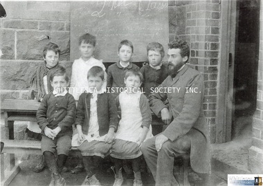
Photograph, South Morang State School
A group of children with a male teacher in front of the South Morang State School.A4 copy of a photograph printed on card with velcro tabs on the rear for display, also digital image on HD.Annotation rear: Sth Morang School No.1975 built 1877. Whittlesea Historical Society.south morang, south morang state school, school group, school children, bluestone building, bluestone school, blackboard -
 Whittlesea Historical Society Inc.
Photograph, Kelsey at South Morang, c.1940-1960
A view of "Kelsey" in Wilton Vale Road, South Morang, and the home of Charles and Louisa Johnson. One of a series of photographs and relatives of the donor, Roslyn Wilson.The house has been demolished.A4 copy of a photograph printed on thick card.Annotation rear: 28. Kelsey / Trees planted by Stanley Johnson c.1940-1960.south morang, kelsey, wilton vale road, charles johnson, louisa johnson, johnson family, stanley johnson -
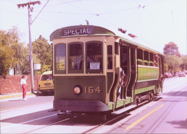 Kew Historical Society Inc
Photograph - S Class 164 in High Street South, 1990
This colour photograph, with 15 others are enlargements gifted to the Society by Mel Lawrence in 2016. They were taken at a commemorative event at the Kew Tram Depot. Laminated colour enlargement of an 'S Class' tram No 164 in High Street South, taken at a re-enactment at the Kew Depot in 1990.Annotation reverse: "Kew Depot 1990. S Class 164 in High Street South."kew tram depot, s class trams -- melbourne -
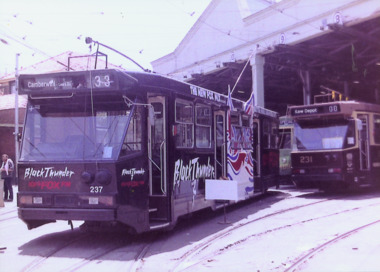 Kew Historical Society Inc
Photograph - A Class 237, A Class 231, & Y Class 469 at the Kew Depot, 1990
This colour photograph, with 15 others are enlargements gifted to the Society by Mel Lawrence in 2016. They were taken at a commemorative event from the Kew Tram Depot. Laminated colour enlargement of two A Class Trams Nos 237 and 231, with a Y Class 469 in the background at a re-enactment in the Kew Depot in 1990.Annotation reverse: "Kew Depot 1990. A Class 237 231 Y Class 469"kew tram depot, a class trams, y class trams, trams -- melbourne -
 Kew Historical Society Inc
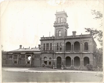
Photograph - 'Raheen', Studley Park Road (Kew), c.1965
"The first section of Raheen was commenced in 1870 with an extension added in 1884. It was designed by William Salway and built for Edward Latham of the Carlton Brewery. Sir Henry Wrixon, prominent Melbourne barrister and solicitor, later owned and resided at the property. In 1917 Raheen was purchased by the Catholic Church and became the official residence of Archbishop Mannix, as well as four other Catholic archbishops of Melbourne. In 1981 the Church sold the property and it again reverted to a private residence." (Victorian Heritage Database, 2023)This work forms part of the collection assembled by the historian Dorothy Rogers (1905-1973), donated to the Kew Historical Society by her son in 2015. The manuscripts, photographs, maps, and documents were sourced by her from both family and local collections or produced as references for her print publications. Many were directly used by Rogers in writing ‘Lovely Old Homes of Kew’ (1961) and 'A History of Kew' (1973), or the numerous articles on local history that she produced for suburban newspapers. Most of the photographs in the collection include detailed annotations in her hand. The Rogers Collection provides a comprehensive insight into the working habits of a historian from the 1960s to the 1970s. Original, monochrome print copy of a photograph of Raheen in Studley Park Road (Kew). The unrendered red brick house with tower has a toe story section at right with a double colonnade and a single story section at left. The photographs predates the restoration of the gardens and house by te. Pratt family. Annotation verso: "Raheen. R. C. Archbishops Palace, Studley Park Road, Kew".reheen, mansions -- kew (vic.), studley park road -
 Kew Historical Society Inc
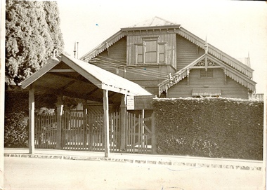
Photograph - Kew Recreation Hall, Wellington Street, c.1950
The Kew Recreation Hall was opened in 1880. For eighty years it was a major venue for concerts, performances, dances and civic events. It was demolished in 1960.This work forms part of the collection assembled by the historian Dorothy Rogers (1905-1973), donated to the Kew Historical Society by her son in 2015. The manuscripts, photographs, maps, and documents were sourced by her from both family and local collections or produced as references for her print publications. Many were directly used by Rogers in writing ‘Lovely Old Homes of Kew’ (1961) and 'A History of Kew' (1973), or the numerous articles on local history that she produced for suburban newspapers. Most of the photographs in the collection include detailed annotations in her hand. The Rogers Collection provides a comprehensive insight into the working habits of a historian from the 1960s to the 1970s. Front view, from Wellington Street, of the former Kew Recreation Hall. The 1880 weatherboard building has a long covered entrance leading to the gabled facade. A smaller gabled room protrudes from one side of the facade. At this stage, the decorative features: gables, brackets, finials, etc were still preserved. The triple window would have been a major source of light for the interior. It appears to have an upper balcony in front of the window. Annotation verso: "28. Kew Recreation Hall prior to demolition. Built about 1880."dorothy rogers, kew recreation hall, buildings -- wellington street (kew) -
 Kew Historical Society Inc
Photograph - Flooding of the Yarra Valley at Kew East, 1974
Flooding of the Yarra Valley, including that section of the Yarra bordering Kew and Kew East in the north and west of the municipality, was a regular occurrence. Extreme flood events of the Yarra River are recorded to have occurred in 1891, 1901, 1916, 1923 and 1934. The Municipality of Kew's response to these floods was to enact planning decisions restricting residential development in flood prone areas following the floods of 1916, 1921 and 1934. While floods continued after the development of the Upper Yarra Reservoir (construction 1948-57), the regularity and extent of these inundations diminished. During the nineteenth century, the land abutting the south side of the Yarra in Kew was devoted to dairy farming. In the twentieth century, before and after the construction of the Eastern Freeway, much of this low-lying area was used as golf courses and public parks.Late example of the capacity of the Yarra Valley at Kew to flood, even though drainage works and the Upper Yarra Reservoir had reduced their regularity.Original black and white print photograph of the low-lying land at East Kew under floodwater on 16 May 1974. The vantage point of the photographer is Lister Street. Flooding was caused by overflowing water in Glass' Creek and the River Yarra. Annotation verso: "Lister St looking same as No.3 / 16 May 1974 11.30"floods, yarra river, glass' creek, lister street -
 Kew Historical Society Inc
Photograph - Flooding of the Yarra Valley at Kew, 1974
Flooding of the Yarra Valley, including that section of the Yarra bordering Kew and Kew East in the north and west of the municipality, was a regular occurrence. Extreme flood events of the Yarra River are recorded to have occurred in 1891, 1901, 1916, 1923 and 1934. The Municipality of Kew's response to these floods was to enact planning decisions restricting residential development in flood prone areas following the floods of 1916, 1921 and 1934. While floods continued after the development of the Upper Yarra Reservoir (construction 1948-57), the regularity and extent of these inundations diminished. During the nineteenth century, the land abutting the south side of the Yarra in Kew was devoted to dairy farming. In the twentieth century, before and after the construction of the Eastern Freeway, much of this low-lying area was used as golf courses and public parks.Late example of the capacity of the Yarra Valley at Kew to flood, even though drainage works and the Upper Yarra Reservoir had reduced their regularity.Original black and white print photograph of the low-lying land at East Kew under floodwater on 16 May 1974. The photograph is taken from 43 Kellett Grove.Annotation verso: "Kellett Gve No.43 / Flood Level / 16 May 1974 11.40am"floods, yarra river, kellett grove -
University of Melbourne, Burnley Campus Archives
Work on paper (Item), C.M.S. Examination (answer paper)
"E. Tyrell" written on each page, annotations in red ink. Marks on back pagee. tyrell, examination papers -
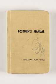 City of Greater Bendigo - Civic Collection
Manual, Post Master General's Department, Postmen's Manual, 1964
When the Commonwealth Post and Telegraph Act was passed in June 1902, and a national Postmaster General's Department (the PMG) was established the responsibility for the nation's mail and telephone services fell on Post Offices. The Bendigo Post Office, built in 1887 and situated on Pall Mall was the central distribution centre for receiving and delivering telegrams and continued to deliver communication and postal services until 1997. Now a Visitor Centre, dedicated volunteers at the Post Office continued to demonstrate and educate the public about the daily workings of the Post Office up until 2019 when Covid 19 disrupted every day life and Ted Rankins, the last Post Master and a long term telegraph volunteer at the Post Office, died. Manuals were issued to postmen to guide them in the delivery of letters and parcels and were small enough to be carried with them. This manual was used by the Bendigo Post Office postmen and is part of the postal collection donated by the Rankins family in memory of Ted Rankins,. Small, creamed coloured cloth covered manual. Contains forty four printed pages and two blank end pages covering all aspects of how to correctly deliver the post. Topics include 'Behaviour', 'Deceased Persons' and 'Bicycles' amongst many others. Book is bound and contains many extra additional paragraphs stuck in on appropriate pages noting changes and amendments. Additional amendments in handwritten red pen also occur on pages 28, 29 and 36.Front cover; Postmen's Manual / Australian Post Office Various annotations and updates throughout. ted rankins collection, bendigo post office, bendigo tourism, city of greater bendigo tourism, post office collection