Showing 354 items
matching valley view road
-
 Kew Historical Society Inc
Journal, Kewriosity : March 1991
Kew Festival 10th March to 24th March - Kew is for living / artwork Heike Effler / p1. Dates for March [1991] / p2. Easter hours [Council Offices] / 2. 10th April [Rates and dog registrations due] / p2. Voters' Roll / p2. [Kew] Community House events / p2. Commentary / Cr Daryl Oldaker p3. Council's casino letter [Willsmere] / p3. Later to the editor [Casino] / E Stanley Meyer p3. Information: your view [Council survey] / p2. Cotham Road rebuilt [reconstruction] / p4. Anybody home? [1991 Census] / p4. Valley views protected [development along the Yarra River] / p4. Reaching the tram [upgrades] / p5. Traffic management update [Area 4, Area 5, Area 6, Area 7, Area 10] / p5. 7,000 more Kewites [projected population growth] / p5. New school buildings [Ruyton Girls' School; Methodist Ladies' College; Trinity Grammar; Xavier College; Genazzano College; Carey Grammar School; Preshil] / p5. High St [Pedestrian] Crossing / p5. St George's amalgamated [with Victoria Parade Geriatric Centre, Henry Pride Unit, Hawthorn Day Hospital] / p6. Youth co-ordination [Youth Workers' Forum] / p6. Bowling vacancies [East Kew Bowling Club] / p6. Driver wanted [for Henry Pride Geriatric Centre] / p6. On World's rooftop [Trinity Grammar students and teachers in Nepal] / p6. Trinity Day / p6. Clergy move / p6. Bus volunteers [needed for Kew Community Bus] / p6. Festival artist [Heike Effler] / p7. Citizens honoured [Australia Day honours] / p7. Medallion award [Royal Guide Dogs Association] / p7. Will bunny arrive? [Three and Fours Kindergarten] / p8. Fun with your children [Highbury Grove Playgroup] / p8. 2nd birthday celebrations [Kew Recreation Centre] / p8. Free electrolysis / p8. Empress of Britain [1938 voyage] / p8. Japanese woodblocks [exhibition at East West Art] / p8. Join the cast [Viola Musical Comedy Society]Kewriosity was a local newsletter combining Kew Council and community news. It was published between November 1983 and June 1994, replacing an earlier Kewriosity [broad] Sheet (1979-84). In producing Kewriosity, Council aimed to provide a range of interesting and informative articles covering its deliberations and decision making, together with items of general interest and importance to the Kew community and information not generally available through daily media outlets.non-fictionKew Festival 10th March to 24th March - Kew is for living / artwork Heike Effler / p1. Dates for March [1991] / p2. Easter hours [Council Offices] / 2. 10th April [Rates and dog registrations due] / p2. Voters' Roll / p2. [Kew] Community House events / p2. Commentary / Cr Daryl Oldaker p3. Council's casino letter [Willsmere] / p3. Later to the editor [Casino] / E Stanley Meyer p3. Information: your view [Council survey] / p2. Cotham Road rebuilt [reconstruction] / p4. Anybody home? [1991 Census] / p4. Valley views protected [development along the Yarra River] / p4. Reaching the tram [upgrades] / p5. Traffic management update [Area 4, Area 5, Area 6, Area 7, Area 10] / p5. 7,000 more Kewites [projected population growth] / p5. New school buildings [Ruyton Girls' School; Methodist Ladies' College; Trinity Grammar; Xavier College; Genazzano College; Carey Grammar School; Preshil] / p5. High St [Pedestrian] Crossing / p5. St George's amalgamated [with Victoria Parade Geriatric Centre, Henry Pride Unit, Hawthorn Day Hospital] / p6. Youth co-ordination [Youth Workers' Forum] / p6. Bowling vacancies [East Kew Bowling Club] / p6. Driver wanted [for Henry Pride Geriatric Centre] / p6. On World's rooftop [Trinity Grammar students and teachers in Nepal] / p6. Trinity Day / p6. Clergy move / p6. Bus volunteers [needed for Kew Community Bus] / p6. Festival artist [Heike Effler] / p7. Citizens honoured [Australia Day honours] / p7. Medallion award [Royal Guide Dogs Association] / p7. Will bunny arrive? [Three and Fours Kindergarten] / p8. Fun with your children [Highbury Grove Playgroup] / p8. 2nd birthday celebrations [Kew Recreation Centre] / p8. Free electrolysis / p8. Empress of Britain [1938 voyage] / p8. Japanese woodblocks [exhibition at East West Art] / p8. Join the cast [Viola Musical Comedy Society]publications -- city of kew (vic.), kewriosity, council newsletters, community newsletters -
 Kew Historical Society Inc
Photograph - River Yarra in Flood from Kilby Road
Flooding of the Yarra Valley, including that section of the Yarra bordering Kew and Kew East in the north and west of the municipality, was a regular occurrence. Extreme flood events of the Yarra River are recorded to have occurred in 1891, 1901, 1916, 1923 and 1934. The Municipality of Kew's response to these floods was to enact planning decisions restricting residential development in flood prone areas following the floods of 1916, 1921 and 1934. While floods continued after the development of the Upper Yarra Reservoir (construction 1948-57), the regularity and extent of these inundations diminished.Print copy of an original photo of the River Yarra in Flood, taken from Kilby Road.VIEW ACROSS YARRA IN FLOOD / FROM KILBY RD KEWkilby road, floods -- kew (vic.), kilby farm -
 Kew Historical Society Inc
Photograph - Flooding of the Yarra River in North Kew, 1934
North Kew, now divided between Kew and Kew East, bordered the Yarra River. As such, it was a region subject to flooding in the Yarra Valley. Development beyond this point (ie Kellett Grove) was limited by the City of Kew's planning regulations. Prior to urban development, the area since European settlement and the first land sales in the district in the 1840s, had been used for dairy farming. Small sepia snapshot of floodwaters taken from near Willsmere Road, in what was then known as North Kew. The point of view is looking towards Fairfield. In the foreground are two figures viewing a group in a rowboat in the middle of the flooded river. Semi-submerged street lighting indicates that entire streets had been. overwhelmed by the flood waters. Verso: WILLSMERE ROAD NORTH KEW / Stamped 3 163yarra river -- north kew, floods -- yarra valley, floods -- north kew, floods -- 1934, natural disasters -- kew, willsmere road -
 Kew Historical Society Inc
Photograph - Flooding of the Yarra River in North Kew, 1934
North Kew, now divided between Kew and Kew East, bordered the Yarra River. As such, it was a region subject to flooding in the Yarra Valley. Development beyond this point (ie Kellett Grove) was limited by the City of Kew's planning regulations. Prior to urban development, the area since European settlement and the first land sales in the district in the 1840s, had been used for dairy farming. Small sepia snapshot of floodwaters in North Kew. The point of view is of two houses belonging to local families that were surrounded by floodwater. Verso: HYATTS HOUSE / WILLSMERE ROAD / Stamped 3 163yarra river -- north kew, floods -- yarra valley, floods -- north kew, floods -- 1934, natural disasters -- kew, willsmere road -
 Kew Historical Society Inc
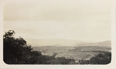
Photograph - Panoramic landscape, c.1926
Henry Beater Christian (1886-1962) , was a descendant of one of the earliest settler families in Kew. Employed at the Kew Asylum as a 'public servant', he was a skilled amateur photographer, photographing numerous scenes in Kew and on his travels around Victoria. The majority of his photographs date from 1916 to 1929. His finest photographs are housed in two photograph albums. Digital copy of a photograph from page 30 of the 47-page photograph album containing 261 gelatinous silver images, loaned by Diane Washfold with permission given to digitise and hold a copy in our collection. John Chapman has written in 'Bushwalking Clubs - A Brief History', about the establishment in Victoria of the first bushwalking club in 1888, and the popularisation of bushwalking during the interwar period. Henry Christian's 'walks' appear to have been undertaken solely or with a companion/s. This black and white panoramic photo is untitled, but follows a page of photos taken on a walking trip between Cockatoo and Gembrook in Victoria. The view selected by the photographer is of a farmed and settled valley with roads and scattered buildings.[Untitled]henry beater christian (1886-1962), landscape photography, christian-washfold collection, photograph albums, bushwalking -
 Kew Historical Society Inc
Plan - Subdivision Plan, Pointed Firs Estate, 1936
The Kew Historical Society collection includes almost 100 subdivision plans pertaining to suburbs of the City of Melbourne. Most of these are of Kew, Kew East or Studley Park, although a smaller number are plans of Camberwell, Deepdene, Balwyn and Hawthorn. It is believed that the majority of the plans were gifted to the Society by persons connected with the real estate firm - J. R. Mathers and McMillan, 136 Cotham Road, Kew. The Plans in the collection are rarely in pristine form, being working plans on which the agent would write notes and record lots sold and the prices of these. The subdivision plans are historically significant examples of the growth of urban Melbourne from the beginning of the 20th Century up until the 1980s. A number of the plans are double-sided and often include a photograph on the reverse. A number of the latter are by noted photographers such as J.E. Barnes.An almost identical plan of the ‘Pointed Firs Estate’ is in the State Library of Victoria. The plan unusually uses a photograph to show the panoramic views from the Estate. A prospective purchaser could expect to look across the Yarra Valley to Eaglemont and Heidelberg. The 36 lots advertised for sale faced Doncaster Road, Houghton Street, Maud Street and Thackray Street in Balwyn North.subdivision plans - balwyn, pointed firs estate -
 Kew Historical Society Inc
Photograph - Yarra Valley Floods: Kew East, 1916
Flooding of the Yarra Valley, including that section of the Yarra bordering Kew and Kew East in the north and west of the municipality, was a regular occurrence. Extreme flood events of the Yarra River are recorded to have occurred in 1891, 1901, 1916, 1923 and 1934. The Municipality of Kew's response to these floods was to enact planning decisions restricting residential development in flood prone areas following the floods of 1916, 1921 and 1934. While floods continued after the development of the Upper Yarra Reservoir (construction 1948-57), the regularity and extent of these inundations diminished. During the nineteenth century, the land abutting the south side of the Yarra in Kew was devoted to dairy farming. In the twentieth century, before and after the construction of the Eastern Freeway, much of this low-lying area was used as golf courses and public parks.One of a collection of photographs of flooding in the Kew section of the Yarra Valley which are in important research resource for the location and extent of flooding in the first half of the twentieth century. Flooding of the Yarra Valley at East Kew in 1916. The view is taken from the intersection of Kilby Road with what is believed to be Birdwood Street, looking across the flood waters to Ivanhoe. The extensive flooded area shown in the photograph would have included the Kew Golf Club. Verso: "Floods along Kilby Road / near Birdwood St? & Kilby Road / 1917? / 87yarra river, yarra valley, floods -- kew, kilby road -- kew (vic.), kew golf club -
 Kew Historical Society Inc
Photograph - Yarra Valley Floods: Kew East, 1916
Flooding of the Yarra Valley, including that section of the Yarra bordering Kew and Kew East in the north and west of the municipality, was a regular occurrence. Extreme flood events of the Yarra River are recorded to have occurred in 1891, 1901, 1916, 1923 and 1934. The Municipality of Kew's response to these floods was to enact planning decisions restricting residential development in flood prone areas following the floods of 1916, 1921 and 1934. While floods continued after the development of the Upper Yarra Reservoir (construction 1948-57), the regularity and extent of these inundations diminished. During the nineteenth century, the land abutting the south side of the Yarra in Kew was devoted to dairy farming. In the twentieth century, before and after the construction of the Eastern Freeway, much of this low-lying area was used as golf courses and public parks.One of a collection of photographs of flooding in the Kew section of the Yarra Valley which are in important research resource for the location and extent of flooding in the first half of the twentieth century. Flooding of the Yarra Valley at East Kew in 1916. The view is taken from a street (maybe Birdwood Avenue) intersecting with Kilby Road looking northeast across the flood waters to Ivanhoe and Heidelberg. The extensive flooded area shown in the photograph would have included remnant dairy farms and the Kew Golf Club. Verso: "Floods / Yarra River / East Kew / Kilby Road / 1917? / 87"yarra river, yarra valley, floods -- kew, kilby road -- kew (vic.), kew golf club -
 Surrey Hills Historical Society Collection
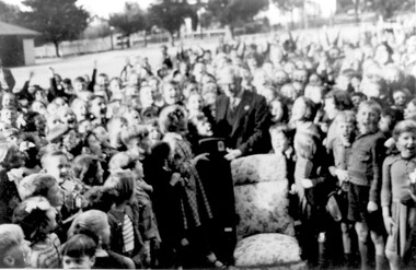
Photograph - Retirement of Mr John Clough as Head Teacher of Surrey Hills Primary School, 1948
John Spencer Clough was the Head Teacher at Surrey Hills during the Depression and the Second World War years. He had a long history in the education department. He was born in Eaglehawk in 1889; married Lily Carpenter in 1915 and died in Camberwell in 1952. He served in France during the First World War. He enlisted in 1915 (SERN 5671) aged 26; occupation school teacher. Electoral rolls place him at the following places as a school teacher: 1912 - Sea View, Warragul 1913 - Leongatha 1914, 1915, 1916 - Carpendeit 1919 - Portland 1922 - Scarsdale 1925, 1926 - Werribee 1928 - Echuca 1931 - Ballarat 1935 - living Wattle Valley Road, Camberwell. At Surrey Hills he was succeeded by Mr Lewis Wheeler. The girl presenting Mr Clough with his retirement gift was Margaret Haines who made the presentation on behalf of the students. A B&W photo of an elderly gentleman surrounded by children. He is wearing a suit and tie and a girl is presenting him with what looks to be a radio. There is a chair with floral covering central to the photo and the gentleman is standing behind it. The background is consistent with a school playground.Number in pencil on the rear - SH1150surrey hills state school, surrey hills primary school, margaret haines, margaret dowsett, john clough, john spencer clough, education, schools -
 Brimbank City Council Art Collection
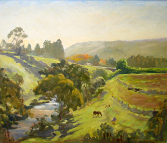
Painting, Maribyrnong River from Horseshoe Bend Road, Keilor, 1977
Local SceneImpressionistic view of valley with a creek running through it. Three horses in the foreground - AR0064Information about the artist on the back. "James Farrell is a member of the Victorian Artists Society" and "is represented at the Australian War Memorial, Canberra".keilor, maribyrnong, river, painting, impressionist, landscape -
Canterbury History Group
Photograph - Canterbury Road, Canterbury, c1910
... View from Wattle Valley Road of Canterbury Road looking... Mansions Horse Drawn Vehicles Goldings Hall View from Wattle Valley ...View from Wattle Valley Road of Canterbury Road looking west. Canterbury Mansions, built 1889 as the Canterbury Club Hotel for William Malone is on left.canterbury, canterbury road, railway crossing, canterbury mansions, horse drawn vehicles, goldings hall -
Canterbury History Group
Photograph - Wattle Valley Street view of the red brick stables at the back of the Canterbury Mansions, Jan Pigot, 1994
Coloured photograph of the Wattle Valley Street view of the red brick stables at the back of the Canterbury Mansionscanterbury, canterbury mansions, shops, wattle valley road, stables -
Canterbury History Group
Photograph - Wattle Valley Street view of the stables behind the Canterbury Mansions, Jan Pigot, 1994
Coloured photograph of the Wattle Valley Street view of the stables behind the Canterbury Mansionscanterbury, canterbury mansions, shops, wattle valley road, stables -
Canterbury History Group
Photograph - Wattle Valley Street view of the red brick stables behind the Canterbury Mansions, Jan Pigot, 1994
Coloured photograph of the Wattle Valley Street view of the red brick stables behind the Canterbury Mansionscanterbury, canterbury mansions, shops, stables, wattle valley road -
Canterbury History Group
Photograph - Rear view of 3 shops in Maling Road. View from the Wattle Valley Road car park, Jan Pigot, 1994
... Rear view of 3 shops in Maling Road. View from the Wattle..., 116 and 118 Maling Road. View from the Wattle Valley Road car... from the Wattle Valley Road car park. Photograph Rear view of 3 ...Coloured photograph of the rear view of 3 shops, No. 114, 116 and 118 Maling Road. View from the Wattle Valley Road car park.canterbury, maling road, shops -
 Mont De Lancey
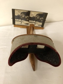
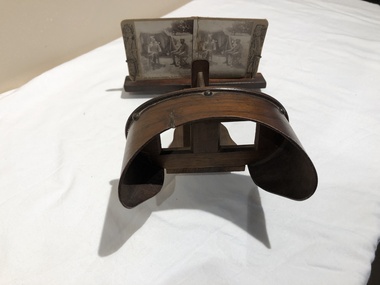
Stereoscope and Box of Stereographs
Wooden stereograph with a metal viewer, through glass slots, and with a wooden foldable handle. Black cardboard box with 48 cardboard stereograph prints (of various views).Box:- "The Rose Stereographs"stereo photographs, stereoscopes -
 Mont De Lancey
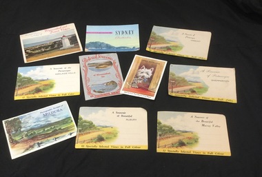
Postcard - Postcards, The Valentine Publishing Co. Pty. Ltd, c 1950's
The souvenir packs of cards open up with various photographs inside. Five are published by Nucolorvue Productions, Mentone, Victoria. One set by Murray Views, Gympie, Queensland. Two sets by The Valentine Publishing Co. Pty.Ltd Melbourne. One set of Colour Photographs by Capt.Frank Hurley. The single postcard is by Valentine's "Mail Novelty" Post Card Copyright. One is addressed to 'Mrs. H. Ellis c/- Mr. E. M. Straw, Harcourt, Vic.'Nine packages of photo souvenir postcards from various Australian cities and towns and one single postcard of a Scottie dog peering out of a doorway. It has a lift up flap with mini folded photographs of Lakes Entrance underneath. Other phoyogtaph selected views and fold out photograph packets of: Sydney, Warrnambool, Mildura, Albury, Shepparton Murray Valley, Orbost Adelaide Hills. The Scottie dog card has handwritten in blue ballpoint pen on the back -' You owe me 5/-' All other sets have the publishing details and a description of the area on the back.postcards, photographic postcards, postal stationery -
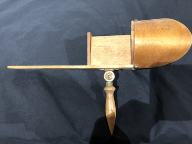
 Mont De Lancey
Stereoscopic Viewer, George Rose, Publisher
Wooden stereoscopic viewer with wire clips to hold double photograph of two men seated outside a tent. Photo-stand slides forwards and backwards. Screws hold face viewer to base. Includes an additional 14 Stereoscopic Views' cards/photographs.On side of photograph: "Rose's Stereoscopic Views Copyright" On bottom of photograph: "2243 The Bushman's Contingent, Colonel Otter and Captain Patterson" On other side of photograph: "Sold only by George Rose Publisher Melbourne"stereoscopes, stereo photographs -
 Mont De Lancey
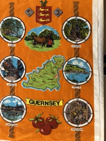
Tea Towel
Guernsey souvenir tea-towel, Orange background with views and map of Guernsey, and a Guernsey Coat-Of-Arms on top."Guernsey"tea-towels -
 Falls Creek Historical Society
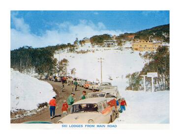
Postcard - Ski Lodges from main road
These photographs were taken in and around Falls Creek by Samuel Keith Pearce and printed for him as a foldout postcard by NuColor Vue. The postcards state they were printed for S. K. Pearce Pty. Ltd of Tawonga and Mount Beauty. Samuel Keith Pearce was born on 24 June 1917 in Armadale, Victoria. By the late 1940s he owned the Mt Beauty Supermarket, Newsagency, Drapery and Hardware store at Mount Beauty and also a store at Tawonga in partnership with his brother Gordon Cathew Pearce. For some time, they operated as Pearce Brothers. In the early 1960s Keith also opened a mini mart In Falls Creek. As well as being a keen photographer and an astute businessman, Keith Pearce was a well-known identity in the Kiewa Valley, making many contributions to the development of the area over a long period. This included serving as a member of the Bright Shire Council for many years. He worked hard to promote the interests of the Upper Kiewa Valley. As a sign of recognition and appreciation for his contribution to the community, the park opposite the grocery store in Mount Beauty was named the SK Pearce Gardens in his honour. Samuel Keith Pearce died on 7 July 1994 in Mount Beauty, VictoriaThis collection of postcards and image is significant because they were commissioned by a highly successful business in Falls Creek, Victoria.A postcard showing the view of lodges at Falls Creek taken from the main road.astra falls creek, falls creek accommodation, falls creek businesses -
 Mont De Lancey
Book, Union Tune Book, Unknown
An introduction to singing prepared with a view to assist those who wish to acquire a sufficient knowledge of the science to sing the praises of God correctly; and also to encourage the cultivation of vocal music in schools. It is of use for beginners.A very damaged antique brown and black covered introduction to singing music book. The title page is missing. The spine has four double gold bands with the title printed in gold lettering. It has 319 songs or hymns included as well as Preliminary remarks addressed to learners, musical characters, intervals, time, diatonic scale, major and minor modes or keys and transposition.non-fictionAn introduction to singing prepared with a view to assist those who wish to acquire a sufficient knowledge of the science to sing the praises of God correctly; and also to encourage the cultivation of vocal music in schools. It is of use for beginners.music books, singing books, singing -
Canterbury History Group
Ephemera - The Canterbury Mansions Apartments, [1995]
Real estate brochure for the sale of a limited number of recently restored 2 bedroom apartments in Canterbury Mansions c.1889. Includes a coloured photograph of the exterior of the building an interior view of the staircase, a lead light window, and a black and white drawing of the building on the back.canterbury, canterbury road, maling road, wattle valley road, canterbury mansions, malones hotel, italianate style, stairs, lead lights, flats -
Canterbury History Group
Photograph - Canterbury Mansions, Jan Pigot, 27/03/1993 12:00:00 AM
Coloured photograph of the view of the Canterbury Mansions from the front door facing Canterbury Road. Also visible are Wattle Valley Road and Maling Road.canterbury, maling road, shops, victorian architecture, canterbury post office -
 Mont De Lancey
Slide Viewer
Wooden slide viewing mechanism with glass viewers and metal tacks with a folding wooden handle.photographic viewing equipment