Showing 127105 items
matching main-road
-
 Ringwood and District Historical Society
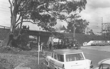
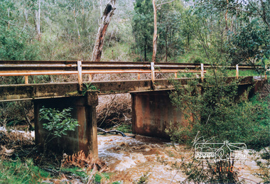
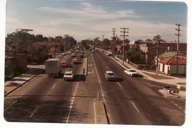
Photograph, Maroondah Highway West, Ringwood- 1965. Wantirna Road bridge widening
Black and white photograph (2 copies)Written below one photograph: "Wantirna Road railway bridge- preparing to widen underpass, 1965. -
 Kew Historical Society Inc
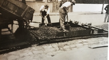
Photograph - Street Works, Studley Park Road, March 1934
Studley Park Road, like most streets in Kew, was originally a dirt road. Street works during the Great Depression included bituminising major roads in the district. This photograph of Council works originated in the City of Kew Engineers Department as a record of works undertaken. It was given to the collection by a Mrs Fisher in 1998.Well provenanced photograph of Council-funded public works in Kew during the Great Depression. Original sepia monochrome positive of Council workers spreading bitumen in Studley Park Road, Kew.Typed reverse: "B4 / Kew C.C. / Spreading premixed material on Studley Park Road with drag spreader, March 1934"roadworks -- kew (vic.), street works -- kew (vic.), public works kew (vic.), studley park road -- kew (vic.), city of kew -- engineers department, city of kew -- public works -- great depression -- 1930s -
 Federation University Historical Collection
Plan - Plan (copy), Melbourne Road Ballaarat, 1857
This map shows the vicinity of the site of the Eureka Stockade. A3 black and whole photocopy of a plan of Ballarat's Melbourne Road. The plan shows Melbourne Road, Proposed Melbourne Road (later Eureka Street), Chamberlain Street, Queen Street, Allotments between Rodier Street and Stawell Street (William Collard Smith, J & T Oddie, F.A. Edward A. Wynne, David Fitzpatrick, Robert Walsh, Charles Spencer, Alfred Lester, Free Trade Hotel)william collard smith, oddie, wynne, fitzpatrick, walsh, spencer, lester, free trade hotel -
 Surrey Hills Historical Society Collection
Photograph, Union Road, Surrey Hills in 1982 (1), 1982
Taken in January 1982; very similar to SHP0635. Surrey Family Hotel (McNeill's Family Hotel) was built in 1888 by Alexander McNeill. It closed as a hotel after the Local Option vote in 1920. Vic Dartnell joined his cousin Percy Cathcart in a pharmacy on the opposite corner in 1936 and moved it to this corner in 1940. His son John followed as the pharmacist and then his daughter Amanda. After the Dartnell family sold the business, the pharmacy continued in a similar manner as a compounding pharmacy and retained 'Dartnell' in its name. Black and white photo of Union Road at the intersection of Canterbury Road. On the left the edge of the Surrey Gardens can be seen and on the right the Dartnell's Pharmacy building on the SE corner and McNeill's Family Hotel building (pre-renovation) on the NE corner. Distinguishable advertising signs include V A Dartnell, Vozzo's Supa Valu Licenced Supermarket on the NW corner and the ANZ Bank on the west side of Union Road beyond the intersection.businesses, shops, union road shops, dartnell's pharmacy, mcneill's family hotel, surrey family hotel, vozzo's licenced supa valu supermarket, anz bank, surrey gardens, vic dartnell, john dartnell, amanda dartnell -
 Melbourne Tram Museum
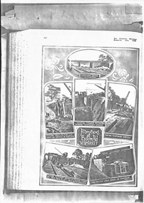
Magazine, Victorian Railways, "Alterations at Epsom Road Newmarket", Jun. 1930
Photocopy of pages 361 and 365 Victorian Railways Magazine, July 1925 and page 485 of September 1925 about the construction of the rail over road/tram bridge in Epsom Road, Newmarket to replace the level crossing. Titled: "Alterations at Epsom Road Newmarket" and "Lifting 28-ton Girders an all-night job!" Gives details and photographs of the work and how financed. Sheets have been stapled together.trams, tramways, victorian railways, epsom road, level crossings, newmarket -
 Mt Dandenong & District Historical Society Inc.
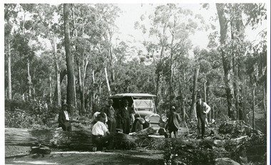
Photograph, Car On New Road Blocked By Tree
Site said to be the new Mt. Dandenong Tourist Road a short distance past present Silvandale Store (Kalorama Post Office now). Early model vehicle and passengers delayed by tree across road. Not much progress being made with axe.kalorama, mt. dandenong tourist road, silvandale store -
 Coal Creek Community Park & Museum
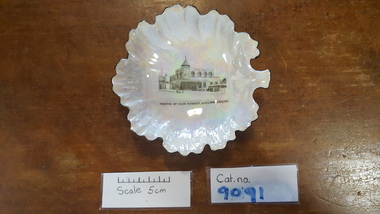
Butter dish
Iridescent white china butter dish in the shape of a fig leaf, with a transfer of a drawing of Korumburra main street on it.'Portion of Main Street Korumburra' under drawing on front China, Made in Chekoslavakia Underneath -
 Surrey Hills Historical Society Collection
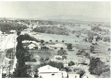
Photograph, Grovedale Road Quarry in the 1920s - looking north, c1920
The quarry was part of John Butler Maling's property. He was one of the original settlers of the area and farmed the area between Weybridge Street and Whitehorse Road. Clay was quarried from part of this area and used to make the bricks used in the construction of his home, known as 'Ancyra'. This is still extant at the corner of Weybridge and James Streets. Maling grazed cows and used the quarry as a water source. He was the uncle of John Butler Maling, Mayor of Camberwell. He was married to Kate Conlon in 1882. They had 3 children: Silas Young, Alick and Zillah. Maling was born in c1829 in Shepreth, Cambridgeshire; he died in Surrey Hills on 9 October 1912 and is buried in Box Hill Cemetery - CE-*-0586. Mrs Kate Maling (born c1859 in Co Meath, Ireland) died at the property on 8 March 1921. She is buried in Brighton General Cemetery. Probate was valued at over 10,000 pounds and included other properties in Sandringham, Hawthorn and Macedon. At the time of her death the Surrey Hills property was described as being 23 cres with 2 brick houses, 1 cow, 2 heifers and 40 fowls or chickens. The property was subdivided after her death. The quarry was filled in after several drownings or near drownings and the land is now occupied by a park and playground maintained by the City of Boroondara. Beckett Park is sited on horizon to the left beyond the trees. This documents the landscape prior to close settlement and is material to early building and farming in the Surrey Hills area.Black and white photo of the quarry between Grovedale Road and James Street taken in the 1920s and looking north. In the foreground is an area of water with high banks dividing the horizontal centre. Beyond are paddocks and trees behind which is a row of at least 3 single-storey houses. Light poles can be seen along a distant street. There are many mature trees in the background. The houses and trees are positioned along Whitehorse Road in the vicinity of Westminster Street. Shadows indicate the photo was taken in early morning or evening.quarries, grovedale road, james street, surrey hills, balwyn, clay quarries, ancyra, kate conlon, kate maling, john butler maling, farming -
 Marysville & District Historical Society
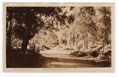
Postcard (item) - Black and white postcard, Rose Stereograph Company, The Alexandra Road, Marysville, Vic, 1913-1967
A postcard in a series produced by the Rose Stereograph Company in Victoria, Australia as a souvenir of Marysville.A black and white photograph of the Alexandra Road in Marysville in Victoria. This road is now known as the Marysville-Buxton Road and joins the Maroondah Highway which leads to Alexandra.POST CARD REAL PHOTO THE "ROSE" SERIES DE LUXE PRODUCED IN AUSTRALIA Published by "The Rose Stereographs"/ Sydney and Melbournealexandra road, marysville-buxton road, marysville, victoria, p. 4978, rose series postcard, postcard, souvenir, alexandra, buxton -
 Eltham District Historical Society Inc
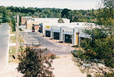
Photograph, Simms Road, Briar Hill, Feb 1990, 1990
Colour photograph of Simms Road, Briar Hill, Feb. 1990. Industrial estate with new buildingssimms road, briar hill, industrial estate -
 Eltham District Historical Society Inc
Photograph, Old aqueduct pipes, Allendale Road, Eltham, March 1991, 1991
Colour photograph of old aqueduct pipes near Diamond Creek crossing, Allendale Road, Elthammaroondah aqueduct, allendale road, diamond creek, eltham, eltham north -
 Eltham District Historical Society Inc
Photograph, One Tree Hill Road Bridge, Christmas Hills
Colour photograph of bridge over Watsons Creek, One Tree Hill Road, Christmas Hillsbridges, watsons creek, one tree hill road, christmas hills -
 Ringwood and District Historical Society
Photograph-B&W, Joan Walker, East Ringwood 2000-Eastfield Road Bridge, 2000
East Ringwood 2000-Eastfield Road Bridge- B&W Photo from Album 6501 -
 Ringwood and District Historical Society
Photograph, No.7 Oban Road, Ringwood - 1981
Black and white photograph of brick factory. Part of a set of photographs taken along Oban Road. -
Whitehorse Historical Society Inc.
Map, Boronia Road, Vermont, 1970
Enlargement of aerial photograph of Boronia Road, Vermont. State Aerial Survey 1970 Run 37Enlargement of aerial photograph of Boronia Road, Vermont. State Aerial Survey 1970 Run 37Enlargement of aerial photograph of Boronia Road, Vermont. State Aerial Survey 1970 Run 37boronia road, vermont, lusk drive, vermont, morack road, vermont south, allison court, vermont, trinian street, vermont, cosgrove street, vermont, mawson court, vermont, aerial photographs -
Whitehorse Historical Society Inc.
Map, Boronia Road, Vermont, 1970
Enlargement of Aerial photograph of Boronia Road Vermont, State Aerial Survey, 1970. Run 37Enlargement of Aerial photograph of Boronia Road Vermont, State Aerial Survey, 1970. Run 37Enlargement of Aerial photograph of Boronia Road Vermont, State Aerial Survey, 1970. Run 37boronia road, vermont, gallus close, vermont, moore road, vermont, carlinga drive, vermont, beleura avenue, vermont, olinda crescent, vermont, penllyne avenue, vermont, holyrood drive, vermont, aerial photographs -
Whitehorse Historical Society Inc.
Map, Husband Road, Forest Hill, 1972
Enlarged aerial photo of area between Canterbury and Husband Roads Forest Hill. Melbourne, 1972Enlarged aerial photo of area between Canterbury and Husband Roads Forest Hill. Melbourne, 1972Enlarged aerial photo of area between Canterbury and Husband Roads Forest Hill. Melbourne, 1972canterbury road, forest hill, husband road, forest hill, hylton crescent, forest hill, sapphire street, forest hill, opal street, forest hill, amber street, forest hill, willurah street, forest hill, nunawading swimming pool, aerial photographs -
Whitehorse Historical Society Inc.
Document, Whitehorse Road Estate
Sale of 158 residential sites in the Whitehorse Road Estate Blackburn.Sale of 158 residential sites in the Whitehorse Road Estate Blackburn by Sole agents Madden & Brady.Sale of 158 residential sites in the Whitehorse Road Estate Blackburn.whitehorse road estate blackburn, madden & brady -
Whitehorse Historical Society Inc.
Document, Kaufmans Road, 1896
Documents and contracts about the sale of land bounded by Kaufmans, Canterbury and Bakers Roads Blackburn, 1896.Documents and contracts about the sale of land bounded by Kaufmans, Canterbury and Bakers Roads Blackburn, 1896.Documents and contracts about the sale of land bounded by Kaufmans, Canterbury and Bakers Roads Blackburn, 1896.canterbury road blackburn, bakers road blackburn, schwab, henri samuel, morton, thomas richards burrowes, land sales, kaufmans road blackburn -
Whitehorse Historical Society Inc.
Document, Edgerton Road Mitcham, 7/12/1973
Copy of letters to C. Schwerkolt re acquisition of land at Edgerton Road, Mitcham by Nunawading Councilland sales, city of nunawading, schwerkolt, charles clarence victor, edgerton road, mitcham -
Whitehorse Historical Society Inc.
Letter - Correspondence, Deep Creek Road, 20/08/1963
Copies of letters re acquisition of portion of the land by Nunawading Council in Deep Creek Road Mitchamland sales, jackschowsky, mary elizabeth, schwerkolt, charles clarence victor, city of nunawading -
 Whitehorse Historical Society Inc.
Photograph, Whitehorse Road, 1983
Donor developed Educational Programme for Blackburn Lake.Laser Print of black and white photo of Whitehorse Road, Mitcham, looking East 1983. (Mounted)meagher, dorothy, whitehorse road, mitcham -
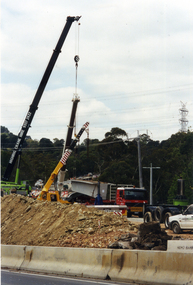 Whitehorse Historical Society Inc.
Photograph, Work on Deep Creek Road, 1/02/2002 12:00:00 AM
Coloured Photo of Crane placing last Span in Bridge over Deep Creek Road, Mitcham.deep creek road, mitcham. -
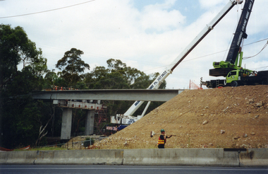 Whitehorse Historical Society Inc.
Photograph, Bridge Work Deep Creek Road, 1/02/2002 12:00:00 AM
Coloured photo of Last Span of Deep Creek Road Mitcham Bridge being put into position.deep creek road, mitcham. -
 Whitehorse Historical Society Inc.
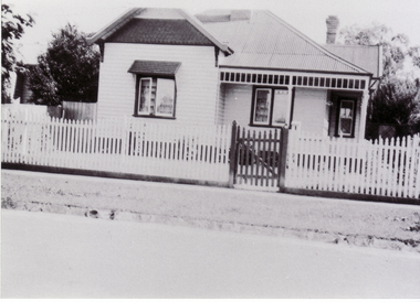
Photograph, 83 Railway Road, Blackburn
Black and white photograph of 83 Railway Road, Blackburn showing weatherboard house with wooden fence.moore, claude, railway road, blackburn, no. 83 -
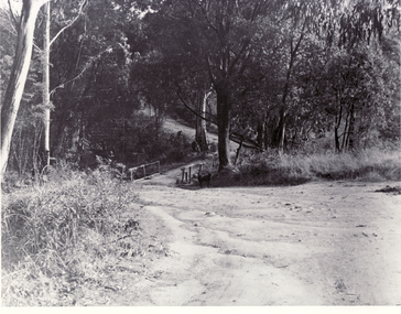 Whitehorse Historical Society Inc.
Photograph, Bridge at Deep Creek Road
Black and white photo of bridge at Deep Creek Road, Mitcham which leads to Loughnan's Hill.deep creek road, mitcham -
 Whitehorse Historical Society Inc.
Photograph - Coloured Photograph, Whitehorse Road Blackburn, 2/08/1979 12:00:00 AM
Coloured photo of Whitehorse Road and Station Street corner, from Blackburn overpass looking Eastwhitehorse road, blackburn -
 Whitehorse Historical Society Inc.
Photograph, Heatherdale Road Mitcham
Black and white copy of Heatherdale Road Mitcham taken from a SEC pylon. Circa 1939.heatherdale road mitcham, easterly view toward mitcham, 1939 -
 Whitehorse Historical Society Inc.
Photograph - Coloured Photograph, Blackburn Railway Road, 2012
Blackburn Railway station opened on 25/12/1882 but was not staffed and the crossing was not manned. The station opened as ac staff and ticket station on 12/8/1889 with hand operated gates.Automatic signalling was introduced on 13/7/1958.Coloured photograph of the Blackburn Road railway crossing at Blackburn, looking east towards Ringwood - 2012blackburn road, blackburn, blackburn railway crossing -
 Whitehorse Historical Society Inc.
Photograph, Whitehorse Road, Mitcham
An early black and white photograph of the Mitcham shopping centre. Cars parked in the side road to the right.whitehorse road, mitcham, mitcham whitehorse road, shopping centre, mitcham