Showing 2458 items
matching aerials
-
 Department of Health and Human Services
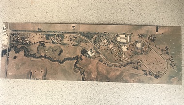
Photograph, Ariel view Colanda grounds (circa 2000)
The Colac, Victoria-based Colanda Centre was one of the last Victorian institutions and offered disability accommodation from 1976, when it was established, until 2019, with its closure. Digitised colour aerial photograph of the Colanda Centre in Colac, Victoria. colanda, colac, disability services, residential services, disability, aerial photograph, digitised photograph -
 Queenscliffe Maritime Museum
Photograph - Aerial photograph of Queenscliff and Swan Island 1960s
Aerial photograph on cardboard depicting Queenscliff and Swan Island C1960s -
 8th/13th Victorian Mounted Rifles Regimental Collection
Photograph - Aerial photograph desert column
Example of aerial photography during WWI in Middle East.Black and White aerial photograph of column of horses in desert terrainmilitary, wwi, world war one, desert, horses, aerial -
 Port Fairy Historical Society Museum and Archives
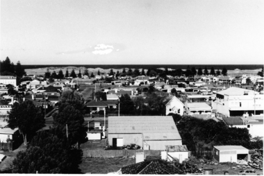
Photograph - Photographs, 1973
Overview of the town in 1973Aerial views from the tower at St Johns Anglican Churchaerial, town, port fairy -
 University of Melbourne, Burnley Campus Archives
Photograph - Black and white print, College and Grounds, c. 1990
Aerial photograph of College and grounds. Could be late 1980'saerial, burnley college -
Port Fairy Historical Society Museum and Archives
Photograph
martin's Point from the air very early (research ongoing)black and white aerial photograph of Martin's Point Port Fairyaerial, martins point, dredge, boat, river, land -
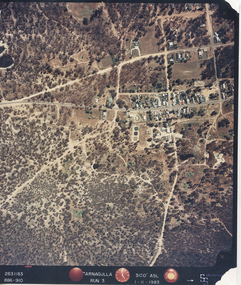 Tarnagulla History Archive
Photograph: Aerial view of Tarnagulla, 11th November 1983
Donald Clark Collection. An aerial colour photograph of Tarnagulla township. Labelled Run 3.tarnagulla -
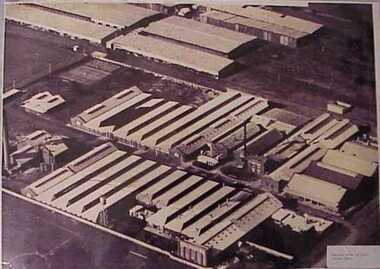 National Wool Museum
Photograph, Aerial view of mill circa 1920
Acquired when "Classweave Industries" closed down.Aerial view of mill circa 1920 H L S POTTER/ PHOTO STORES/...textile mills woollen mills, classweave industries pty ltd federal woollen mills ltd, textile mills, woollen mills -
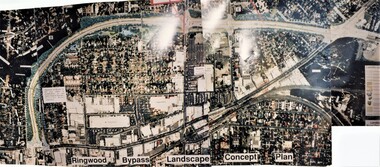 Ringwood and District Historical Society
Photograph, Ringwood Bypass Landscape Concept Plan
Three colour phototraphs forming composite panoramic aerial view (undated)."Ringwood Bypass Landscape Concept Plan" -
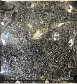
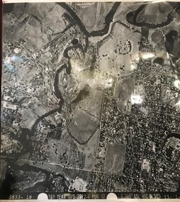 Greensborough Historical Society
Aerial Photograph, Yan Yean M/S 7922 Run 17 No. 3833-18, 1/11/1984
Covers Viewbank area: North boundary Martin's Lane; South boundary Yarra River & Birrarung Park; East boundary east of Plenty RiverLaminated black and white aerial photograph; adjoins 6227 on west sideviewbank -
 Greensborough Historical Society
Aerial Photograph, Yan Yean M/S 7922 Run 17 No. 3833-20, 01/11/1984
Covers Rosanna and parts of Viewbank and Heidelberg. East boundary Price Park; West boundary Hurstbridge railway lineLaminated black and white aerial photograph; adjoins 6226 on east siderosanna, viewbank, heidelberg -
Glenelg Shire Council Cultural Collection
Photograph - Photograph - Dutton Way, n.d
Port of Portland Authority ArchievesColoured aerial photo of Dutton Way, Showing the rock wall and groynes -
 Glenelg Shire Council Cultural Collection
Photograph - Photographs - Australian Estates (Portland) Pty Ltd Wool Process & CSR Softwoods, n.d
Port of Portland Authority archives.Front: (no inscriptions) Back: (no inscriptions)port of portland archives -
Glenelg Shire Council Cultural Collection
Postcard - Postcard - Glenelg River, Nelson, n.d
Coloured postcard. Aerial view of the Glenelg River at Nelson, bridge in foregroundnelson, postcard -
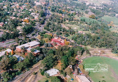 Eltham District Historical Society Inc
Photograph, Aerial view of Eltham Shire Office and Eltham Library precinct, 1994, 1994
Colour photograph of oblique aerial view centred on Eltham Library, 1994eltham, eltham library, eltham shire offices, eltham central park, alistair knox park, main road, aerial photographs -
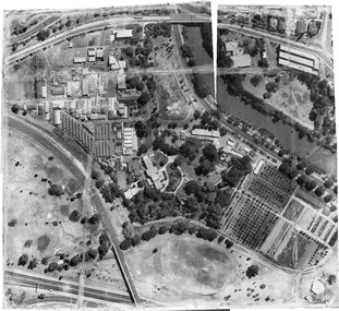
Federation University Historical Collection
Photograph - Colour - Aerial, Lindsay Stepanow, Federation University Mount Helen Campus, 28/05/1993
Aerial photograph of the Mount Helen campus of what was then Ballarat University College. aerial photograph, mount helen campus, mount helen campus aerial, ballarat university college -
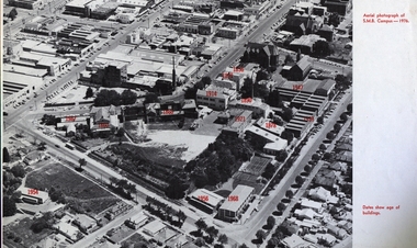 Federation University Historical Collection
Image, Ballarat School of Mines Aerial View with Dates of Buildings, 1976
Aerial photograph of the Ballarat School of Mines, with establishment date for each building. ballarat school of mines, aerial, buildings, former ballarat gaol, mining laboratory, hillman hall, former supreme court, administration building, ballarat technical art school, former wesley church, ballarat girls technical school, ballarat junior technical school, albert street, grant street, lydiard street south, armstrong street south, dana street -
Federation University Historical Collection
Booklet, Wendy Morris, A Guide to Maldon, 1983, 1983
Soft covered booklet featuring an aerial view of the town of Maldon on the cover. heritage, tourism, maldon, mining, streetscape, townscape, gardens, quartz reef mining, geology, maldon goldmines, maldon hospital, kangaroo hotel, architecture, conservation and planning, cast iron, forests, mount tarrangower, nuggetty ranges, beehive -
Glenelg Shire Council Cultural Collection
Photograph - Photograph - Early Shipping: Ocean/Railway Pier, 14/01/1958
Port of Portland Authority ArchivesFront: Back- Purple stamp-'14 January 1958'port of portland archives, portland harbour, ship berthed, ocean pier, aerial photo -
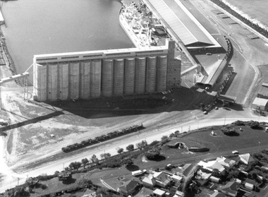 Glenelg Shire Council Cultural Collection
Photograph - Photograph - ariel view of grain silo construction, Portland, 1970
Port of Portland Authority archivesFront: (no inscriptions) Back: (no inscriptions)port of portland archives, grain silos, aerial photography -
Glenelg Shire Council Cultural Collection
Photograph - Photograph - Point Danger and rifle range, n.d
Port of Portland Authority Archivesport of portland archives, point danger -
Port Melbourne Historical & Preservation Society
Photograph - Aerial view of Port Melbourne, 1978
Two A3 photocopies of aerial view of Port Melbourne c 1978local government - city of port melbourne, phillip donnellon -
Port Melbourne Historical & Preservation Society
Photograph - Aerial view of land reclamation at Webb Dock, Port Melbourne, 1997
Colour aerial photo showing land reclamatioon at Webb Dock, 1997piers and wharves - webb dock, melbourne harbor trust - port of melbourne authority -
Port Melbourne Historical & Preservation Society
Photograph - SS Nairana, C.1951
The SS Nairana was launched 1915 by William Denny & Brothers in Dumbarton Scotland the 3,402 ton steamer was requisitioned by the Royal Navy and served during WW1. In 1922 she was transferred to Tasmanian Steamers and, apart from again being requisitioned for war service in WW2, was used as a Bass Strait ferry until 1948. The Nairana was blown ashore onto Port Melbourne beach during a severe gale on 19 February 1951. After salvage what remained of the wreck was blown up in 1954. B & W aerial photograph of SS Nairana and Port Melbourne foreshoress nairana, transport - shipping -
Tatura Irrigation & Wartime Camps Museum
Book, Ernestine Hill, Water Into Gold, 1965
Depicts pioneers of irrigation - Chaffey bros and story of irrigation on the MurrayBlue soft cover. Depicting aerial photo of farmland. White letteringirrigation, chaffey -
Tatura Irrigation & Wartime Camps Museum
Photograph, Luise Katz, 1942-1946
Artifacts made in Camp 3.Colour photograph of drawing of Camp 3 aerial (more or less) view.camp 3, hand made objects, camp 3 hand crafts, templer society -
Tatura Irrigation & Wartime Camps Museum
Book, Water into Gold, 1965
Depicts pioneers of irrigation, Chaffey Bros., and story of irrigation on the Murray RiverBlue soft cover, depicting aerial photo of farmland, white lettering.water into gold, irrigation, hill e, tatura, books, history, local, rural, industry -
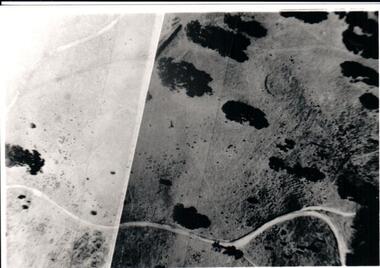 Hume City Civic Collection
Photograph, Late 1980s
A study was conducted to locate a number of Aboriginal sites in Sunbury in the 1980s. This study took place as a result of the expanding development on Sunbury's outskirts.A black and white aerial view of one of the Aboriginal ring sites in Sunburyaboriginal sites, aboriginal rings, george evans collection -
Lakes Entrance Regional Historical Society (operating as Lakes Entrance History Centre & Museum)
Photograph - Framed photograph, 2002c
Mounted on chipboard, rear of backboard has strap for wall hangingMounted photograph, aerial view of waterway and housing area from Kalimnaphotography, photographs, slides, film -
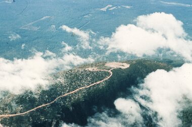 Stawell Historical Society Inc
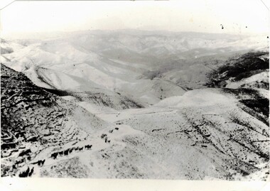
Slide, Ian McCann, Aerial View Grampians & Construction of Bellfield, 1960's
Colour Slide; aerial View of Mt William through scattered cloudsgrampians, mt william