Showing 64199 items
matching shire-of-orbost
-
 Lakes Entrance Regional Historical Society (operating as Lakes Entrance History Centre & Museum)
Book, Orbost Historical Society, Tambo East Gippsland Water, 2005
A Journal presenting history of the Orbost district produced from information gathered during a historical bus trip taken by thirty local residents to Bete Bolong Newmerella Corringle and Lochend Orbost Victoriatransport, agriculture, world war 1939 - 1945 -
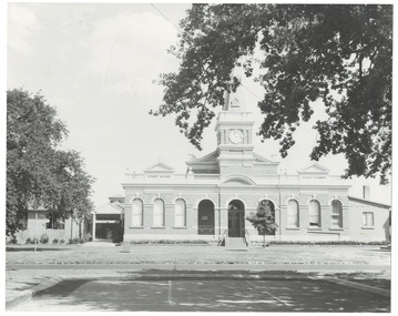
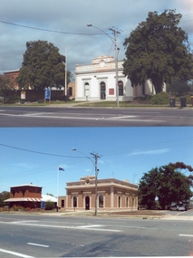 Stawell Historical Society Inc
Photograph, Stawell Shire Hall -- Before and After colour photos of the Shire Hall, one photograph taken in 2011
... Stawell Shire Hall -- Before and After colour photos of the ...Two Stawell Shire Hall colour photos showing the changes over time to the landscape around the Shire building. In 2011 the two Norfolk Island hibiscus trees were removed. In the photo with the trees removed the building is painted a brown colour and has the Australian flag flying on the flag post. Two colour photographs of Stawell Shire Hall showing how the landscape around the building has changed over time. In 2011 the Norfolk Island Hibiscus trees were removed. The building was painted white in one photo and when the trees removed painted a brown colour similar to the initial brick of the building. stawell -
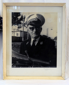 Orbost & District Historical Society
framed black and white photograph, mid - second half 20th century
This is a photograph of Mr Clem Heather, band leader. Clem Heather was a Forestry employee in Orbost, The Orbost Workers' Band was started in 1889 by Donald and Archie Munro. The band folded after the town was devastated by floods in 1893. Charles Spink reformed the group in 1905. It split in 1908 and the breakaway band was named the Orbost Workers Band. The two bands, The Orbost Workers and Orbost Town Band would often compete against each other. Eventually, in 1913, the two bands amalgamated to form the Orbost Municipal band. The old Orbost Municipal Band recorded its last meeting in 1941 -a lack of effort and membership. The new Orbost Municipal Band was restarted by Clem Heather (a previous member) on Wednesday 20th September, 1961 and continued into the late 1980s when lack of interest caused it to become defunct.This is a pictorial record associated with the Orbost Brass Band. The various Orbost bands over the years played a major role in community activities providing entertainment and musical experiences for the many membersA black / white photograph of a man in a brass band uniform. He is holding a brass instrument (French horn?). It is under glass in a white wooden frame.on front -????????? Orbostheather-clem orbost-brass-band music recreation -
Lakes Entrance Regional Historical Society (operating as Lakes Entrance History Centre & Museum)
Photograph, 1950 c
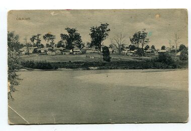
Small black and white photograph showing main street Nicholson St with two double story buildings on right one being state Savings Bank and seven shops, car on right 1950 vintage buildings on east side of street Orbost VictoriaOrbostpostal services, transport -
Stawell Historical Society Inc
Book - Report, The Remnant Vegetation of the Shire of Stawell, 1990
... The Remnant Vegetation of the Shire of Stawell ...Study of what remains of Native Vegetation towards conserving what remains on Public and Private land as well as revegetation through shireBound PaperThe Remnant Vegetation of the Shire of Stawell by John Miller. School of Biological and Chemical Sciences Ballarat University Collage -
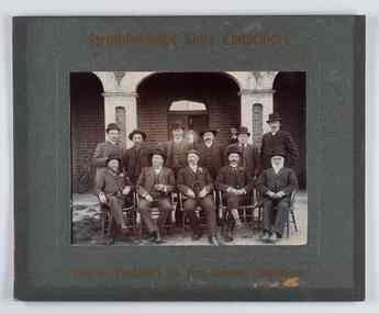 City of Greater Bendigo - Civic Collection
Photograph - Councillor group portrait, W H Robinson, Strathfieldsaye Shire Council, 1909
The district of Strathfieldsaye was proclaimed in 1861 and named a Shire on the 17th September in 1866. It remained a shire until amalgamation in 1994 when it became part of the City of Greater Bendigo. The shire was located 8 km to the south- east of Bendigo and covered an area of 601 square kilometres and extended from the Calder Highway to the Coliban and Campaspe Rivers. The shire's administration centre was in Strathfieldsaye until 1972 when new offices were opened in Kennington.Photographic group portrait of eleven Strathfieldsaye Shire Councillors in front of the Strathfieldsaye Shire Hall. Five men are seated and six standing with one man standing further in back ground on the building's verandah. Photograph is attached directly to green mount card and framed. Gold lettering on mount.Strathfieldsaye Shire Councillors / R. B. Brennan (Sec.) W. J. Lowdes S. Doak M. Burns () N Condon B. Code (Inspector) / WH Robinson Photo Bendigo / T Somerville / W. I. Long / Fred Osborne (President) H Keck / W Dresler / With the President's (Cr. Fred Osborne) Compliments / September 23rd, 1909shire of strathfieldsaye, strathfieldsaye shire council, president of strathfieldsaye shire, strathfieldsaye shire hall -
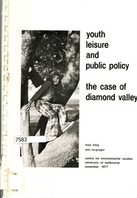 Greensborough Historical Society
Book - Report, Ross King et al, Youth, leisure and public policy: the case of Diamond Valley, 1977, 1977_11
... Youth, leisure and public policy: the case of Diamond...Shire of Diamond Valley ...119 pages text and black and white line drawings and tables. One colour fold out map. White plastic binding. non-fictionshire of diamond valley, leisure activities, sport -
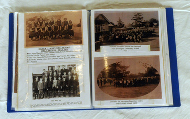 Orbost & District Historical Society
book, Smith, Margaret, The School Book - A Collection of School Photos from 1890
... The School Book - A Collection of School Photos from 1890 ...This book was compiled by Margaret Smith a long time member of Orbost Historical Society and Slab Hut manager/volunteer.This book documents the education history of the Orbost district and is a useful research tool.The School Book - a display book containing the history and photographs of schools in the Orbost district from 1890 to 1959. The texts and photographs are in plastic sleeves.slab-hut orbost-education education schools -
 Orbost & District Historical Society
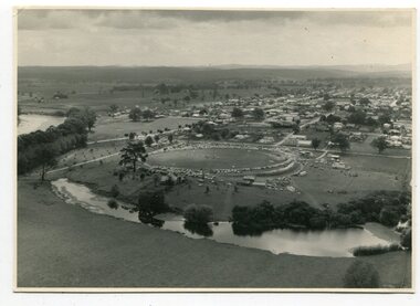
black and white photographs, March 10 1961
These photographs are pictorial record of Orbost in 1961.They enable us o observe the objects in their spatial context and in detail. They are useful for reference.Four black / white aerial photographs. there are spare copies of each. 3276.1 is an aerial photograph of the Orbost Show with Lochiel Park in the foreground. 3276.2 is an aerial photograph taken over a township. 3276.3 shows the Orbost High School on the left. 3276,4 shows the high school in the foreground.on the back of each is "March 10th 1961 Aerial of Orbost"photographs-aerial-orbost-1961 orbost-1961 lochiel-park -
 Federation University Historical Collection
Booklet, John Fraser & Son, Shire of Buninyong, 1858-1958, 1958
... Shire of Buninyong, 1858-1958 ...Booklet of loose pages held together with yellow ribbon. Photographs of Buninyong.non-fictioncentenary, fisken, shire council, district road board, buninyong, 1958, dallas brookes, governor of victoria, archibald fisken -
 Orbost & District Historical Society
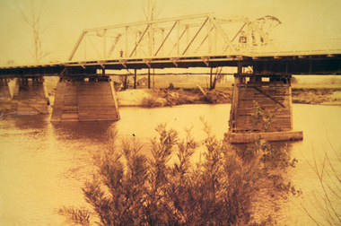
photograph, first half of 20th century prior to 1976
... first half of 20th century prior to 1976 ...Purchased from Orbost Op shop several years ago. Original owner unknown. This bridge over the Snowy River was opened on July 4 1922. It was constructed in 1922 alongside the previous suspension bridge. Its building was a combined effort of the Victorian Railways and the Country Roads Board at a cost of 35,000 pounds. It was replaced in 1976 by the present bridge after several major floods.This bridge was replaced in 1976 after several major floods.A wooden framed photograph of the second Snowy River bridge at Orbost.photograph snowy-river-bridge -
 Buninyong & District Historical Society
Photograph - Original Photograph, Derek Leather, Town Hall in 1970's, front view, showing part of 1950'2 Shire Offices, Copy of original photograph made 1970-80
... Town Hall in 1970's, front view, showing part of 1950'2...Copy of original photograph made 1970-80 ...Historic BuildingsB/W Photo Town Hall in 1970's, front view, showing part of 1950's Shire Officesbuninyong, learmonth st., town hall precinct -
 Orbost & District Historical Society
black and white photograph, Campbell. D.S, late 19th century ?
This is a photograph of the settlement of Orbost on the banks of the Snowy River,. In the foreground in the paddock there is a water trough (Bills?) and the B Drain can be seen on the far left. D.S. Campbell had a stationery store in Nicholson Street Orbost and published several black and white postcards of Orbost.This is a pictorial record o The township of Orbost in the late 19th century.A black / white photograph / postcard. There is a river in the foreground with houses and shops in the background behind a cleared paddock.on front - Orbostorbost-19th-century snowy-river -
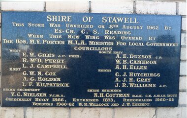 Stawell Historical Society Inc
Photograph, Stawell Shire Hall 1866 -- 04 Photos -- Coloured
Shire Hall 4 Colour photos. Three photos (84.10a, b, c,) showing the brick veneer addition to the Stawell Shire Hall. One photo (84.10) of the plaque bearing the councillors names. These photos were taken in 2013 and each photo shows a different view of the brick veneer addition. One view is the front of the brick addition and other 2 are of the rear view of the 1962 addition.Four colour Photographs. Three of the brick additions to the Stawell Shire Hall in 1960-1962. One photograph of the plaque bearing the councillors names.Shire of Stawell. This stone was unveiled on 8th August 1962 by Ex. Cr. C. S. Reading When this new wing was opened by the Hon. M.V. Porter M.L.A. Minster for Local Government. Councillors WEST - E. W. Giles J.P. Pres., R. McD. Perry., L. J. Campbell., EAST - G. W. N. Cox., A. G. Holden., I.F. Kilpatrick., NORTH EAST - A. E. Duxson J.P., W.B. Cameron., A.H. Ellen., NORTH - C.J. Hutchings., A. J. H. Gray., J. R. Williams J.P., Shire secretary V. C. Neilson F.I.M.A. Shire Engineer N. H. Cottman B.C.E. C.E. A.M.I.E (Aust) Originally Built 1866. Extended 1873. Remodelled 1960-62 Builders 1960-62 W.R. Willcock and J.W. Kennedy.stawell -
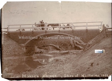 Whittlesea Historical Society Inc.
Photograph - Copy, Monier Bridge, Shire of Whittlesea, 1901
... Monier Bridge, Shire of Whittlesea, 1901 ...Shire Engineer William Henry Lockwood standing on the concrete Monier bridge across the Barber's Creek at Yan Yean. Bridge built by Monash and Anderson was completed in 1901. Copy of original sepia photograph.Monier Bridge, Shire of Whittlesea, 1901. Handwritten on the back of the photograph, designed by W.H.Lockwood/ Barbers Creek bridge Plenty Rd/Whittlesea Historical & Conservation Society/Shire Engineer William Henry Lockwood/ monier bridge, william henry lockwood, monash, anderson, 1901, barber's creek, yan yean, whittlesea, engineer, concrete bridge -
![Correspondence, Shire of Diamond Valley, Greensborough District Centre [Letter], 06/01/1989](/media/collectors/4f729f5697f83e03086015b8/items/520c24bc2162ef085803edef/item-media/58ad17ced0ce3d14e8edcc01/item-fit-380x285.jpg) Greensborough Historical Society
Greensborough Historical SocietyCorrespondence, Shire of Diamond Valley, Greensborough District Centre [Letter], 06/01/1989
... Shire of Diamond Valley ...The letter was sent to the Fraser Family in response to a query on the future of the Greensborough District Centre.At the time of its creation Greensborough was undergoing a lot of change and there was a fear among older residents that the character of the town would be lost.A 5 page letter on the letterhead of the former Shire of Diamond Valley. Nilgreensborough district centre, shire of diamond valley, fraser family, development, 1989 -
Lakes Entrance Regional Historical Society (operating as Lakes Entrance History Centre & Museum)
Financial record - Ledger, Country Roads Board Cash Book, 14885
... Shire of Tambo ...Entries are hand written in ink, 177 of 201 pages have been use, leather bound with heavt cardboard cover, foolscap size.A ledger of cash expenditure by Country Roads Board in Shire of Tamboaccounts book -
Lakes Entrance Regional Historical Society (operating as Lakes Entrance History Centre & Museum)
Financial record - Ledger, Country Roads Board Cash Book, 11536
... Shire of Tambo ...Entries are hand written in ink, majority of pages have been used, leather bound with heavy cardboard cover.A ledger of cash expenditure by Country Roads Board in Shire of Tamboaccounts book -
 Ringwood and District Historical Society
Book, Footprints - History of the Shire of Tullaroop
... Footprints - History of the Shire of Tullaroop ...History of the Shire of Tullaroop -
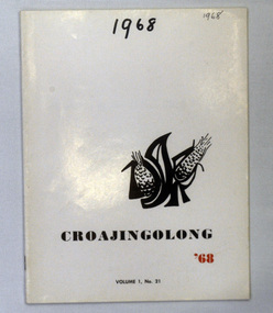 Orbost & District Historical Society
magazines, Croajingolong 1968, 1968
This is the twenty-first issue of the annual Orbost High school magazine. The name Croajingolong derives from the Australian Aboriginal Krauatungalung words galung, meaning "belonging to" and kraua, meaning "east". 2216.1 belonged to Mary Gilbert, a former teacher at the school. 2216.2 belonged to Brenda Murray, a former mayor of East Gippsland Shire and a prominent Orbost resident.This magazine is a useful reference tool.Two copies of a magazine, Croajingolong '68. It has a white cover with black and red print,. Vol.1 No.21. On the right side is a stylised drawing of two ears of corn with black letters (?) around it. (OHS?)2216.2 is stamped Orbost & District Historical Society.croajingolong orbost-high-school -
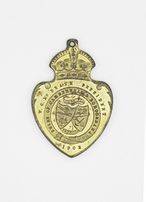 Camberwell Historical Society
Medal, 1902 Edward VII Coronation Medalet for the Shire of Boroondara and Camberwell, 1902
... 1902 Edward VII Coronation Medalet for the Shire of ...In 1902, the Shire of Boroondara was renamed the Shire of Boroondara and Camberwell. Gold coronation small medal. One side depicts the shield of Camberwell and the other side has the profiles of Edward VII and Princess Alexandra.One side is inscribed with 'W.G. McBeath President' and 'Shire of Camberwell and Boroondara 1902' and the other 'Edward VII and Alexandra - Crowned 26 June 1902.'boroondara, edward vii, princess alexandra, medalet, camberwell, coronation -
Federation University Historical Collection
Plan, Shire of Buninyong Warrenheip water supply general management
... Shire of Buninyong Warrenheip water supply general ...The Shire of Buninyong was later amalgamated into the City of Ballarat.Map shows the 1966 district boundaries of Ballarat and the layout of properties and water pipes in Warrenheip 1966.Gutteridge, Haskins & Davey Consulting Engineers Shire of Buninyong Warrenheip water supply general management September 1966buninyong, vincent, warrenheip, gutteridge, haskins & davey, water supply -
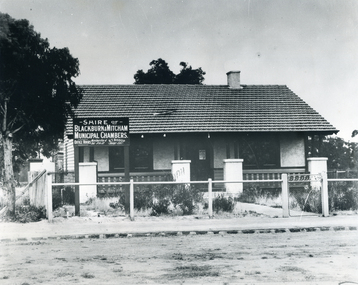 Whitehorse Historical Society Inc.
Photograph, Municipal Chambers - Shire of Blackburn & Mitcham - First Office
... Municipal Chambers - Shire of Blackburn & Mitcham - First ...When the Shire of Blackburn and Mitcham was proclaimed on 27th May 1925, the second meeting of the Shire was held in the hall of the Methodist Church on Monday 28th September 1925 at 7.30pm.|Three ensuing meetings were also held there and following meetings were at the dwelling in Whitehorse Road, which was purchased by the Shire for use as their office. (By Coincidence this dwelling was almost on the site of their new Municipal Offices.)Black and white picture - Municipal Chambers of Shire of Blackburn & Mitcham located opposite the present offices of City of Whitehorse in Whitehorse Road, Nunawading|See also NP35 & NP36 after it was destroyed by fire.municipal chambers - first office, shire of blackburn and mitcham, whitehorse road, nunawading, methodist church -
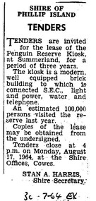 Phillip Island Conservation Society Inc.
Work on paper - Photocopy of newspaper cutting, Wonthaggi or Powlett Express newspaper, "SHIRE OF/ PHILLIP ISLAND/ TENDERS", 30.7.1946
... "SHIRE OF/ PHILLIP ISLAND/ TENDERS" ...Shire of Phillip Island managed the Phillip Island Penguin Parade during this era, and made several improvements for visitors including the building of a kiosk for food and beverage and some souvenirs. The building was located on a bitumen area at the base of the hill along with a brick toilet block. The area was actually raised from creek bed adjacent to the bitumen area, with Little Penguin rookery either side. The Shire tendered out the contract for the running of this kiosk on a 3 yearly basis.This small public notice from a Wonthaggi newspaper at a time when no local newspaper was being published on Phillip Island, marks the time when the Shire of Phillip Island began to increase provision of tourist facilities at the Penguin Parade. The number of visitors being 100,000 for the previous year is also an excellent indication of the popularity of the Penguin Parade. The listing of infrastructure available to the building is useful.Photocopy of Public Notice, Rectangular. Single collumn with heading, sub-heading, 5 paragraphs of text and Name and position of Shire Secretary. Black and white."30-7-64 EX" Meaning: 30.07.1964. Powlett Express newspaper.phillip island penguin parade, shire of phillip island, penguin parade kiosk, tender process, penguin parade visitor numbers, sec state electricity commission, stan harris phillip island shire secretary -
 Ballan Shire Historical Society
Map - Map. Shire of Ballan, Shire of Ballan
... Shire of Ballan ...This is a fairly comprehensive map of the former Shire of Ballan which is now amalgamated into the Shire of Moorabool.A black and white map of the Shire of Ballan showing major roads, rivers, towns, settlements, State parks and forests and land subdivisions. It appears to be a copy of the original as no dates or maker or printer appear on the map. There is a scale of 2 miles to 1 inch.gordon, ballan, bungal, kerrit bareet, borhoneyghurk, bungeeltap, ballark, yaloak, gorong, beremboke, wallace, ingliston, hunterston, millbrook, bradshaw, myrniong, blackwood, moorarbool, greendale, bayup, trentham, bullarto, korweinguboora, glenlyon, bolwarra -
Tatura Irrigation & Wartime Camps Museum
Book, Shire of Rodney Pound Cash Book 1930-1982, 1930
... Shire of Rodney Pound Cash Book 1930-1982 ...Records of payment to Rodney Shire for impounded stock 1930-1982Shire of Rodney Pound cash book 1930-1985. Faded back cover, very faded front cover. Suede leather spine, red label at top, blue label lower.shire of rodney, impounded stock -
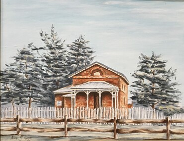 Pyrenees Shire Council
painting, Anne McGregor, Untitled (Lexton Shire), c1985
significant as a work of art by local Pyrenees artist, locally significant to the Central Highlands Region of Victoria as a representation of local landscape and/or culturelandscape with Lexton Shire OfficesAffixed front: Presented by Lexton's Anniversary Committee to the Lexton Shire Council IN RECOOGNITION OF IT'S VALUABLE SUPPORT & ASSISTANCE IN THIS, VICTORIA'S 150TH ANNIVERSARY YEAR 14-4-85 -
Stawell Historical Society Inc
Map, Shire of Stawell, 1880
... Shire of Stawell ...Shire of Stawellstawell -
Stawell Historical Society Inc
Map, Shire of Stawell
... Shire of Stawell ...Shire of Stawellstawell -
Stawell Historical Society Inc
Map, Shire of Stawell, 1963
... Shire of Stawell ...Shire of Stawellstawell