Showing 2044 items
matching building and construction
-
 Ringwood and District Historical Society
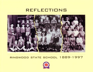
Book, Reflections - Ringwood State School 1889-1997
This book was created for the centenary celebration of the Ringwood State School No. 2997, located on Greenwood Avenue, Ringwood, Victoria. Construction began on the new building in 1921. The building centenary celebration was held at that site, now Maroondah Federation Estate, on 12th November, 2022, a year later than expected due to the Covid epidemic.Collage of students' class photographs and Ringwood State School logo on front of yellow soft-cover book, containing multiple contributors' photographs and written memories.Acknowledgements: First and foremost, the people who provided personal stories are to be congratulated, having contributed intimate memories and photographs. This is their book. Contributors include: Russ Haines Thomas Guest Bill Adolphson Lindsay Adolphson Kerri Kirby (Mathieson) Glenda Oliver (Pottenger) Ian McCleave Dawn Rees (nee Riedel) Linda Cuthill Russ Read Marie Gribben Sir Ronald East Jennie Roe Coral Powell Liz Seaton Stan Mathieson Alan Rittman Denise (White) Wilson Ian Wilton Neville Burns Marion Tremlett (nee Hayward) Gavin Fry Lynette Broadway-Hill James Rogers Suzanne Strout (nee Rogers) Patricia Rogers Peter Fry Malcolm Hugh Powell -
 University of Melbourne, Burnley Campus Archives
Photograph - Black and white prints and negatives, Athol Shmith Studio Illustrative Photography, Les Provan Collection, 1922-1946
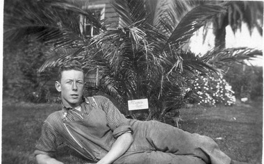
Photographs donated by James Leslie (Les) Provan. (1) Note by T.H. Kneen 6 May 1992, "James Leslie Provan went to Melbourne University - graduated B. Agr. Sc-and later 1942 became Principal Burnley and 1946 Principal Dookie Agricultural College."Black and white photographs and negatives. (1) 2 photographs and negative. Les Provan reclining on the ground infront of a Kentia palm and part of the pavilion behind. (2) Includes negative. Les Provan and another male student seated on the lawn. (3) Note attached, "English lad, Fred ?, ?, Jack Allen." 4 male students seated on the lawn in front of the Pavilion. (4) Male student with calf. (5) 3 male students squatting on the lawn in front of the pavilion, one holding a football. Note by E.B. Littlejohn 6 May 1992, "Student on left is R. Fred Gillespie ? Jack Allen (centre) was later on staff as an Instructor. (6) Mrs Kneen and two children walking through the Administration Building under construction. (7) 4 men standing next to Dahlias judging them. (8) Student walking along path between ponds and Pavilion.(1) On reverse, "Student Les Provan 1922 &1923. Dux 1923. Background is Kentia Palm & the Chemistry classroom of the old Pavilion. (2) On reverse, "Les Provan & ? 1923." (3) On reverse, "Group of male students 1922 or 1923." (4) On reverse, "? name an English lad, student 1922 or '23." (5) On reverse, "The Football Team L to R. Fred---Jack Allen & ? 1923." (6) On reverse, "The new College building in course of construction early 1946. Mrs. Kneen & children." (7) On reverse,"Judges in trial Dahlias Burnley 1943. Left to right Jack Reid, Castell, Charlie Stone, Geo. Russ, Norm Scable." (8)) On reverse, "June Bishop-student," and, "Athol Shmith Studio Illustrative Photography 125 Collins Street, Melbourne C.1. Cent. 27. No 10383 Position J." Note by E.B. Littlejohn 4 March 1992, "June Bishop standing at junction of paths one of which leads to main entrance to Pavilion."les provan, kentia palm, chemistry classroom, pavilion, james leslie provan, dookie agricultural college, jack allen, r. fred gillespie, dahlias, jack reid, castell, charlie stone, geo. russ, norm scable, june bishop, cows, student group 1922-1923, football team 1922-1923, administration building construction, mrs kneen, kneen children, athol shmith, garden view, dux, calf, main building construction -
 Orbost & District Historical Society
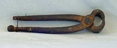
carpenter's pincers, first half 20th century
The main purpose of carpenter's pincers is to pull out nails from wood without damaging the surface. These carpenter's pincers would have been used in Orbost in the construction of new buildings or on a rural property for maintenance.This item is an example of a domestic carpentry tool in common use before the widespread use of power tools.Pincers with long, rounded, pivoted metal handles ending in a pair of jaws for gripping and extracting nails or holding or gripping small objects.woodworking tool pincers carpentry -
 Eltham District Historical Society Inc
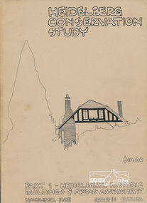
Book, Graem Butler, Heidelberg Conservation Study, Part 1 Heidelberg Historic Buildings and Areas Assessment by Graeme Butler, November 1985
Historic Buildings and Areas Assessment by Graeme Butler. Part 1 of award winning study carried out in 1982 in collaboration with a community advisory committee to Heidelberg City Council. Pioneering identification of a broad range of heritage assets varying from buildings, gravestones, farm structures, landscape areas, mileposts, divided street construction, in a time when buildings only were assessed in municipal studies.2 v. : ill., maps ; 29 cm.significant buildings heidelberg victoria, history development of heidelberg victoria, man-made landscape heidelberg victoria, significant precincts heidelberg victoria, conservation study, graeme butler -
 Orbost & District Historical Society
albums, late 1980's
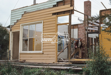
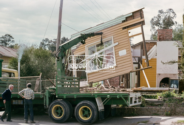
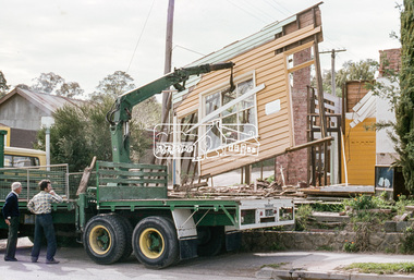
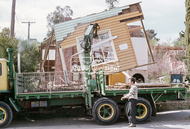
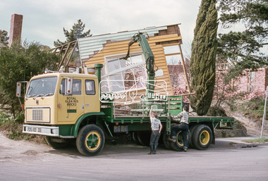
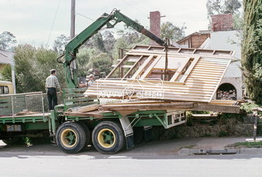
These two albums were used at the Slab Hut - Orbost Visitor Information Centre. The Orbost Visitor Information Centre is situated in Forest Park on Nicholson Street. The centre is housed in the historic Slab Hut. The hut was an original family dwelling built in 1872, on a site approximately three kilometres upstream from the junction of the Buchan and Snowy Rivers. No nails were used in the construction; it was all wired together. After a period in storage the slab hut was opened in its present location in Orbost as the Information Centre in 1987.These albums are contemporary records of the construction and relocation of an iconic Orbost building, the Slab Hut.Two large photo albums. 2280.1 has no front cover. The back cover and spine are red. The pages are black and most photos are labelled. They are photographs of the Orbost area. 2280.2 has brown covers. It contains photographs of the construction of the gardens and buildings around the Slab Hut (Orbost Visitor Information Centre). On the cover in gold print is "PHOTOS".slab-hut-orbost album-photographs-orbost -
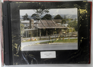
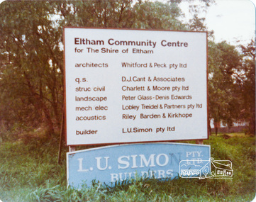 Eltham District Historical Society Inc
Photograph, Peter Bassett-Smith, Construction of Eltham Community Centre, June 1977, 1977
Building construction sign - Architects: Whitford & Peck Pty Ltd; Quantity Surveyor: D.J. Cant & Associates; Structural Civil Engineers: Charlett & Moore Pty Ltd; Landscape: Peter Glass, Dennis Edwards; Mech Elec: Lobley Treidel & Partners Pty Ltd; Acoustics: Riley Barden & Kirkhope; Builder: L.U. Simon Pty Ltdeltham, eltham community centre, buildings, construction -
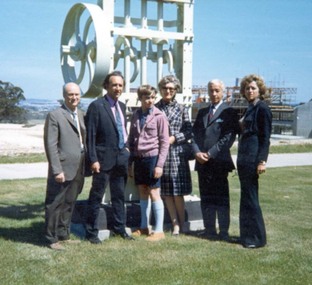 Federation University Historical Collection
Photograph, Descendants of Professor Ferdinand Krause at Mt Helen, c1969
Professor Ferdinand Krause lectered at the Ballarat School of Mines from 1880-1995. His descendant returned to Ballarat, visiting the new campus at Mt Helen. The information on this photograph was provided by E.J. Tippett. There is a possibility the subjects of the photo are descendants of Herbert Krause.Descendants of Prof. F.M. Krause stand in front of a battery stamper that had been used at the Ballarat School of Mines, and transferred to Mt Helen around 1969. The construction of the first buildings of the new Mt Helen campus are evident in the background. Prof Krause's son stand 2nd from the right, Phil Day is second from the left.ballarat institute of advanced education, fm krause, mount helen, ej tippett, herbert krause, derek krause -
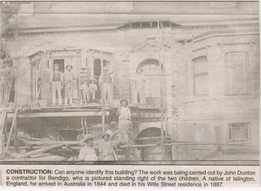 Bendigo Historical Society Inc.
Newspaper - JENNY FOLEY COLLECTION: CONSTRUCTION
Bendigo Advertiser ''The way we were'' from 2003. Construction: can anyone identify this building? The work was being carried out by John Dunton a contractor for Bendigo, who is pictured standing right of the two children. A native of Islington, England, he arrived in Australia in 1844 and died in his Wills Street residence in 1897. The clip is in a folder.newspaper, bendigo advertiser, the way we were -
 Bendigo Historical Society Inc.
Slide - RALPH BIRRELL COLLECTION: EIG SCHOOL, c1966
EIG School - Ralph Birrell Collection. - Construction of Latrobe Uni. C1966. Bendigo Institute of Technology, Engineering School, Applied Science. Looking due south from Brennan Park Swimming Pool car park, across Brennan Park swimming pool to LaTrobe University, gives a view of the two towers of the Business and Technology Building.Kodakeducation, tertiary, latrobe university bendigo, eig school - ralph birrell collection. - construction of latrobe uni. c1966. bendigo institute of technology, engineering school, applied science. looking due south brennan park swimming pool car park, brennan park swimming pool to latrobe university, gives view two towers business technology building. -
 Robin Boyd Foundation
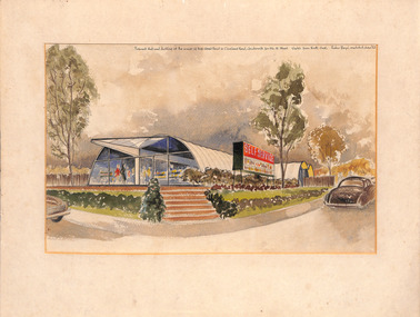
Work on paper - External Perspective, Robin Boyd, June 1953
Robin Boyd designed a supermarket and dwelling in Jordanville (now Ashwood). This design was the unique ctesiphon system of construction where walls and roof form one self supporting unit. This building is registered on Heritage Council Victoria. External perspective of a proposed shop and dwelling and environment. Has a mount, unframed.On the top right "Proposed shop and dwelling at the corner of High Street Rd and Cleveland Rd, Jordanville for Mr W. Wood. Sketch from North End. Robin Boyd architect June '53".ctesiphon, jordanville, robin boyd, heritage, ashwood, ohm2022, ohm2022_27 -
 Hume City Civic Collection
Photograph, early 1990s
In 1963 construction of the new municipal shire offices began and the new offices were opened in October 1963. Over the years other buildings were added to the complex which included the Library and the George Evans Museum.A coloured photograph of the front view of the former Shire of Bull, Shire offices and a part of the garden area in the front with trees and a wooden seat.shire of bulla council offices, shire of bulla, george evans collection -
 Queenscliffe Maritime Museum
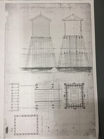
Plan - Plan for a tide gauge house
An extract from the Board of Land and Works building estimates for 1858 shows an allocation of 500 Pounds for the construction of Tide Gauge Houses at various places. A copy of this plan was obtained from the Hydrographic Survey Office in Queenscliff. https://www.parliament.vic.gov.au/papers/govpub/VPARL1857-58NoB1.pdfCopy of a plan for a tide gauge house at Queenscliff 1858Clerk of works office Geelong 27 July 1858queenscliff, tide gauge house, plan -
 Tarnagulla History Archive
Wooden shingle from roof of Tarnagulla State School
David Gordon Collection. This small shingle was recovered during re-roofing operations at the Tarnagulla Primary School. It dates from the original construction of the building in 1874, and is in quite a good state of preservation considering its purpose. -
 Robin Boyd Foundation
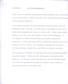
Document - Manuscript, Robin Boyd, Canberra, 1967
Boyd outlines the history of Canberra's design and construction. He argues that Canberra's strength is its planning and axially-based landscaping, but that it lacks the buildings which make the Le Corbusier's Chandigarh interesting. Boyd is highly critical of Chandigarh as an urban environment and concludes that for non-architects, planning and connection to nature is more important than buildings.Original manuscript published as 'Canberra Master Plan: Walter Burley Griffin' in World Architecture 4, John Donat (ed.), Viking Press 1967, pp 202-205.Typewritten (p/copy), quarto, 6 pageswalter burley griffin, canberra, john overall, lake burley griffin, oscar niemeyer, le corbusier, chandigarh, city beautiful, garden city, urban planning, robin boyd, manuscript -
 Eltham District Historical Society Inc
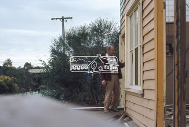
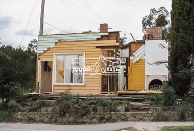
Slide, Joh Ebeli, Preserving parts of the old Baker's house, corner of York Street and Main Road, Eltham, c.Sep. 1979
The old weatherboard building, possibly dating from the 1860s, comprised a dwelling with a shop in the front room opening off a timber verandah deck which directly fronted the Main Road footpath. At the rear is a brick building of much later date which was for many years used for the bakery. The buildings were demolished for flat construction. Joh Ebeli and Elwers Howard endeavoured to preserve some parts of the house.35 mm colour positive transparency Mount - Agfachrome Professional black (Germany) 4 dotsmain road, old eltham bakery, york street -
 Eltham District Historical Society Inc
Slide, Joh Ebeli, Preserving parts of the old Baker's house, corner of York Street and Main Road, Eltham, c.Sep. 1979
The old weatherboard building, possibly dating from the 1860s, comprised a dwelling with a shop in the front room opening off a timber verandah deck which directly fronted the Main Road footpath. At the rear is a brick building of much later date which was for many years used for the bakery. The buildings were demolished for flat construction. Joh Ebeli and Elwers Howard endeavoured to preserve some parts of the house.35 mm colour positive transparency Mount - Agfachrome Professional black (Germany) 4 dotsmain road, old eltham bakery, york street -
 Kew Historical Society Inc
Plan, Melbourne & Metropolitan Board of Works : Borough of Kew : Detail Plan No.1581, 1904
The Melbourne and Metropolitan Board of Works (MMBW) plans were produced from the 1890s to the 1950s. They were crucial to the design and development of Melbourne's sewerage and drainage system. The plans, at a scale of 40 feet to 1 inch (1:480), provide a detailed historical record of Melbourne streetscapes and environmental features. Each plan covers one or two street blocks (roughly six streets), showing details of buildings, including garden layouts and ownership boundaries, and features such as laneways, drains, bridges, parks, municipal boundaries and other prominent landmarks as they existed at the time each plan was produced. (Source: State Library of Victoria)This plan forms part of a large group of MMBW plans and maps that was donated to the Society by the Mr Poulter, City Engineer of the City of Kew in 1989. Within this collection, thirty-five hand-coloured plans, backed with linen, are of statewide significance as they include annotations that provide details of construction materials used in buildings in the first decade of the 20th century as well as additional information about land ownership and usage. The copies in the Public Record Office Victoria and the State Library of Victoria are monochrome versions which do not denote building materials so that the maps in this collection are invaluable and unique tools for researchers and heritage consultants. A number of the plans are not held in the collection of the State Library of Victoria so they have the additional attribute of rarity.Original survey plan, issued by the MMBW to a contractor with responsibility for constructing sewers in the area identified on the plan within the Borough of Kew. The plan was at some stage hand-coloured, possibly by the contractor, but more likely by officers working in the Engineering Department of the Borough and later Town, then City of Kew. The hand-coloured sections of buildings on the plan were used to denote masonry or brick constructions (pink), weatherboard constructions (yellow), and public buildings (grey). The streets and built structures in this plan were surveyed in 1903 and released to contractors in 1904. In addition to the designation of building types by colour, the plan includes detailed descriptions of land use and ownership. While many buildings remain from this period, a number of the buildings represented have been demolished including the original Kew Town Hall, and the Congregational and Roman Catholic churches in Walpole Street. While the mansion ‘Illapa’ in Princess Street is still extant – now part of ‘Rylands’ – the neighbouring mansion ‘Elsmere’ was demolished some decades ago. Rivalling Illapa and Elsmere in size were two mansions in Walpole Street, one named on the plan as ‘Gnarlbine’. Over time, Kew Junction and the south side of High Street have been reconfigured and widened, so that the commercial buildings on the corner of Princess and High Street no longer exist. A surprising feature of this part of central Kew to the northwest of Kew Junction is the amount of vacant land. In a number of cases, this land is noted by the contractor as used for vegetable gardens.melbourne and metropolitan board of works, detail plans, maps - borough of kew, mmbw 1581, cartography -
 Kew Historical Society Inc
Plan, Melbourne & Metropolitan Board of Works : Borough of Kew : Detail Plan No.1592, 1905
The Melbourne and Metropolitan Board of Works (MMBW) plans were produced from the 1890s to the 1950s. They were crucial to the design and development of Melbourne's sewerage and drainage system. The plans, at a scale of 40 feet to 1 inch (1:480), provide a detailed historical record of Melbourne streetscapes and environmental features. Each plan covers one or two street blocks (roughly six streets), showing details of buildings, including garden layouts and ownership boundaries, and features such as laneways, drains, bridges, parks, municipal boundaries and other prominent landmarks as they existed at the time each plan was produced. (Source: State Library of Victoria). This plan forms part of a large group of MMBW plans and maps that was donated to the Society by the Mr Poulter, City Engineer of the City of Kew in 1989. Within this collection, thirty-five hand-coloured plans, backed with linen, are of statewide significance as they include annotations that provide details of construction materials used in buildings in the first decade of the 20th century as well as additional information about land ownership and usage. The copies in the Public Record Office Victoria and the State Library of Victoria are monochrome versions which do not denote building materials so that the maps in this collection are invaluable and unique tools for researchers and heritage consultants. A number of the plans are not held in the collection of the State Library of Victoria so they have the additional attribute of rarity.Original survey plan, issued by the MMBW to a contractor with responsibility for constructing sewers in the area identified on the plan within the Borough of Kew. The plan was at some stage hand-coloured, possibly by the contractor, but more likely by officers working in the Engineering Department of the Borough and later Town, then City of Kew. The hand-coloured sections of buildings on the plan were used to denote masonry or brick constructions (pink), weatherboard constructions (yellow), and public buildings (grey). In MMBW Plan No.1592, the pink line indicates that area of the plan for which the contracting engineer was responsible. Included in the Plan are a number of primarily brick villas in a section of Belmont Avenue off Cotham Road. The house ‘Uvadale’ north of Belmont Avenue, and facing Cotham Road is also included in the contract. Excluded from the contract but shown on the Plan are ‘Glendonald’, ‘Mont Belmont’ and ‘Gilden’.melbourne and metropolitan board of works, detail plans, survey plans - borough of kew, mmbw 1592, cartography -
 Kew Historical Society Inc
Plan, Melbourne & Metropolitan Board of Works : Borough of Kew : Detail Plan No.1561, 1905
The Melbourne and Metropolitan Board of Works (MMBW) plans were produced from the 1890s to the 1950s. They were crucial to the design and development of Melbourne's sewerage and drainage system. The plans, at a scale of 40 feet to 1 inch (1:480), provide a detailed historical record of Melbourne streetscapes and environmental features. Each plan covers one or two street blocks (roughly six streets), showing details of buildings, including garden layouts and ownership boundaries, and features such as laneways, drains, bridges, parks, municipal boundaries and other prominent landmarks as they existed at the time each plan was produced. (Source: State Library of Victoria). This plan forms part of a large group of MMBW plans and maps that was donated to the Society by Mr Poulter, City Engineer of the City of Kew in 1989. Within this collection, thirty-five hand-coloured plans, backed with linen, are of statewide significance as they include annotations that provide details of construction materials used in buildings in the first decade of the 20th century as well as additional information about land ownership and usage. The copies in the Public Record Office Victoria and the State Library of Victoria are monochrome versions which do not denote building materials so that the maps in this collection are invaluable and unique tools for researchers and heritage consultants. A number of the plans are not held in the collection of the State Library of Victoria so they have the additional attribute of rarity.Original survey plan, issued by the MMBW to a contractor with responsibility for constructing sewers in the area identified on the plan within the Borough of Kew. The plan was at some stage hand-coloured, possibly by the contractor, but more likely by officers working in the Engineering Department of the Borough and later Town, then City of Kew. The hand-coloured sections of buildings on the plan were used to denote masonry or brick constructions (pink), weatherboard constructions (yellow), and public buildings (grey). MMBW Detail Plan 1561 outlines those residences in the area bordered by Burke Road, Loxton Street, Mount Street and Barkers Road that had been constructed by 1905 when the land was surveyed. At this time, the area nearest Burke Road had been subdivided and developed whereas the lands to the west were as yet undeveloped. The houses represented are not named on the Plan.melbourne and metropolitan board of works, detail plans, mmbw 1561, cartography -
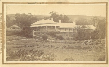 Bacchus Marsh & District Historical Society
Photograph, Glenmore Homestead 1883
This homestead was built by Charles Griffith on a 55,000 acre Run. It replaced an earlier dwelling which was a slab hut with a bark roof. Charles Griffith, an Irish barrister, with his friend, James Moore, settled on Glenmore Station in the Parwan Valley in 1840. Their partnership lasted until 1848. In 1846, whilst in Ireland, Griffith married Miss Jane Catherine Magee, then returned to Glenmore and later took his nephew, Molesworth Richard Greene, into partnership, which arrangement proved to be long and prosperous. In 1857, they bought runs at Mount Hope and Mount Pyramid, which they kept until the days of free selection. Griffith led an active and successful public life.He was a member of the new Victorian Legislative Council in 1851, and was later an elected representative of the Legislative Assembly 1853-1859. He occupied many important public positions, including that of magistrate for Bacchus Marsh. Griffith was a devout Anglican and hosted Bishop Charles Perry at his station near Bacchus Marsh in 1849. He died in 1863 at his home in South Yarra.Small sepia unframed photograph on card with gold border framing photograph. Housed in the album, 'Photographs of Bacchus Marsh and District in 1883 by Stevenson and McNicoll'. The photograph shows a view of an extensive single-storey homestead consisting of three adjoining buildings, with a further building on the left of the main property. The series of three buildings is built in an elevated position, with pathways leading through a garden. At the front there is a vegetable garden which seems to be still in a state of development. The main house, possibly of brick, is set at an angle to the other two in this complex. It has a hip roof with a concave verandah on two sides with arched barge boards and simple unadorned pillars. There appears to be a hammock slung between two pillars. Two chimneys can be seen on this dwelling.The adjoining building is of a simpler design, with a lower roof line and a verandah running along the front. Two chimneys can be seen, one emitting smoke. This middle building may be a kitchen and rooms for day-to-day use. The third building is also of a simpler design, with a gable above a verandah. The purpose of this building is less clear. The different styles of construction suggest that these buildings were built separately at different times for different purposes. To the left of the main group of buildings is another cottage, smaller and of a simpler design. A fence runs along the front, clearly separating this building from the others, suggesting it may have been the dwelling of an overseer.On the front: Stevenson & McNicoll. Photo. 108 Elizabeth St. Melbourne. COPIES CAN BE OBTAINED AT ANY TIME. On the back: LIGHT & TRUTH inscribed on a banner surmounted by a representation of the rising sun. Copies of this Portrait can be had at any time by sending the Name and Post Office Money Order or Stamps for the amount of order to STEVENSON & McNICOLL LATE BENSON & STEVENSON, Photographers. 108 Elizabeth Street, MELBOURNE. stevenson and mcnicoll 1883 photographs of bacchus marsh and district, farms bacchus marsh, charles james griffith 1808-1863, glenmore station -
 Unions Ballarat
If you don't fight, you lose : a look into the development of the CFMEU in WA and general aspects of unionism, 2011
The book is a history of building and construction unions in Western Australia. There is also acknowledgement of the CFMEU's and BLF's work elsewhere. The book has been criticised for ignoring the influences of the Communist Party, The book is also known under the following titles: If you don't fight, you lose : a history of the CFMEU WA If you don't fight, you lose : a history of the Construction, Forestry, Mining and Energy Union Western Australia Relevant to the history of unions in Australia and, particularly, Western Australia. Pertinent to the history of the BLF and CFMEU.Paper; book. btlc, ballarat trades hall, ballarat trades and labour council, construction, forestry, mining and energy union, cfmeu, blf, builders labourers federation, gallagher, norm, cummins, john, reynolds, kevin, mcdonald, joe, malone, paddy, unions, history, western australia, o'shea, clarrie -
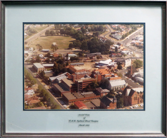 Federation University Historical Collection
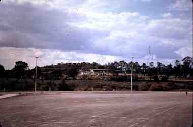
Photograph - coloured, Aerial view of SMB Lydiard Street Campus, March 1982, March 1982
SMB was established on the area on the area of the Ballarat Gaol. The Gaol has been demolished but the Brewery still stands. Hillman Recreation Centre is under construction. The tennis courts are still evident, now the site of the M B John Building.Timber frame with silver/red paint, pale blue and dark blue mount board with glass.ballarat school of mines, ballarat gaol, hillman recreation building, tennis courts, m b john, brewery -
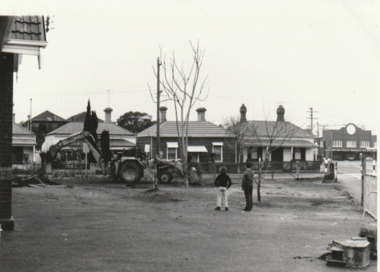 Port Melbourne Historical & Preservation Society
Photograph - Preparation for Adventure Playground, Nott Street Primary School, 1977
Construction of Adventure Playground Nott Street Primary School. in the background can be seen the former Port Melbourne Picture Theatre at 284 Bay Street. Sign shows that in 1977 it was Dudley Pty Ltd. The building was gutted by fire in 2015. B & W photograph of preparations for an Adventure Playground on the Nott & Farrell Streets corner, Nott Street Primary School 1977education - primary schools, nott street primary school -
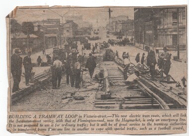 Melbourne Tram Museum
Newspaper, "Building a Tramway Loop", Apr. 1926
Newspaper cutting from an unknown Melbourne newspaper with "Building a Tramway Loop", with a photo of track construction in Victoria St between Swanston St and Elizabeth St to enable tramcars to be moved between depots and for special traffic. Photo taken looking west, just shows the curve into Swanston St. Timeline history gives the opening of 31/5/1926trams, tramways, victoria st, track construction, swanston st