Showing 2044 items
matching building and construction
-
 Kew Historical Society Inc
Archive (Sub-series) - Subject File, 'Fairview', 34 Wrixon Street (Kew), 1979
Various partiesReference, Research, InformationSecondary Values (KHS Imposed Order)Subject file containing information about Fairview (built 1924 for F.F. Robinson, proprietor of Yarra Falls Mills). The house replaced an earlier single-storey brick house, also called Fairview. A comprehensive report prepared by Alan Willingham in 2006 found that there was no evidence that the architect Desbrowe-Annear incorporated parts of the original building in the new construction. The work by Willingham is a ‘Cultural and Architectural History and Assessment of the Cultural Heritage Significance’ of the building, prepared for Carey Grammar School. The Willingham report was donated by Sr Ruth Anderson.kew (vic) - history, fairview - 34 wrixon street - kew (vic), cluny house - 34 wrixon street - kew (vic), f.f. robinson, alan willingham, harold desbrowe-annearkew (vic) - history, fairview - 34 wrixon street - kew (vic), cluny house - 34 wrixon street - kew (vic), f.f. robinson, alan willingham, harold desbrowe-annear -
 Melbourne Legacy
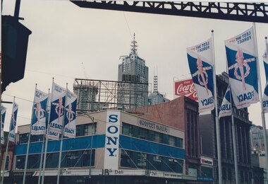
Photograph - Photo, Legacy Appeal, 1990
Three photos of Swanston St and Lonsdale St with Legacy banners on the street poles. The slogan was 'Lest YOU Forget' which was used in 1989 and 1990. The photos show some of the buildings and businesses from that time. The building on the corner was called Godfrey House at that time. It is still in existence with the Sony sign on the corner. The office building under construction in the background was originally called Nauru House (later rebadged as Aon). Was with photos in a scrapbook covering the 1980s to 1990s.A record of a type of promotion for the Legacy Appeal in early 1990s.Colour photo x 3 of banners along Swanston St to promote Legacy.legacy appeal, fundraising, badge week, streetscape, promotion -
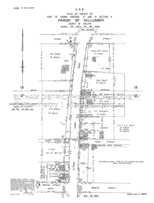
 Eltham District Historical Society Inc
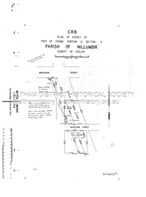
Document - Survey Plan, Country Roads Board, SP 6801, Eltham-Yarra Glen Road; Brougham St to Bridge St, 1958
1958 C.R.B. Plan of Survey of Part of Crown Portion 12 Section 4 Parish of Nillumbik, County of Evelyn Eltham-Yarra Glen Road, Shire of Eltham Shows Surveyor field notes, property ownership and building type and construction.a.j. collis, a.s. & c.g.h. fitzpatrick, board of land & works, bridge street, brougham steet, commonwealth bank of australia, country roads board, eltham, eltham rsl sub-branch, f.h. collis, f.m. smith, f.n. & e.j. burgoyne, franklin street, h.c. & r.e. burgoyne, j. jorgenson, j.f. & j.e. morris, j.n. & h.c. burgoyne, j.s. blow, john street, main road, p.e. smith, pitt street, r.j. dripps, s.j. taylor, survey plan, trustees of the eltham methodist church, 1958, eltham-yarra glen road, neil webster collection -
 Eltham District Historical Society Inc
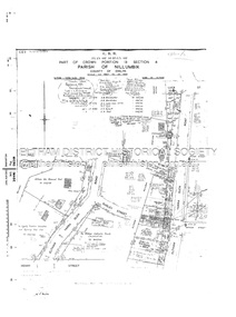
Document - Survey Plan, Country Roads Board, SP 6802, Eltham-Yarra Glen Road; Brougham St to Dalton St, 1958
1958 C.R.B. Plan of Survey of Part of Crown Portion 12 Section 4 Parish of Nillumbik, County of Evelyn Eltham-Yarra Glen Road, Shire of Eltham Shows Surveyor field notes, property ownership and building type and construction.1958, eltham-yarra glen road, a.f. munday, bible street, brougham steet, country roads board, dalton street, eltham, j.p. & e.a. sanders, j.w. & e. m. graham, l.c. skipper, l.m. jarrold, main road, napoleon street, survey plan, neil webster collection, franco and co -
 Eltham District Historical Society Inc
Document - Survey Plan, Country Roads Board, SP 6313, Eltham-Yarra Glen Road; Luck St to Henry St, 1956
1956 C.R.B. Plan of Survey of Part of Crown Portion 13 Section 4 Parish of Nillumbik, County of Evelyn Eltham-Yarra Glen Road, Shire of Eltham Shows Surveyor field notes, property ownership and building type and construction.eltham-yarra glen road, country roads board, eltham, main road, survey plan, 1956, a.l. lyon, a.w. brinkkotter, arthur street, c.r. burkett, dudley street, e.n. staff, eltham war memorial trust, henry street, luck street, pryor street, the board of land & works, the equity trustees executors and agency coy ltd, the roman catholic trusts corporation, victorian railways commision, neil webster collection -
 Kew Historical Society Inc
Plan, Melbourne & Metropolitan Board of Works : Borough of Kew : Detail Plan No.1578, 1904
The Melbourne and Metropolitan Board of Works (MMBW) plans were produced from the 1890s to the 1950s. They were crucial to the design and development of Melbourne's sewerage and drainage system. The plans, at a scale of 40 feet to 1 inch (1:480), provide a detailed historical record of Melbourne streetscapes and environmental features. Each plan covers one or two street blocks (roughly six streets), showing details of buildings, including garden layouts and ownership boundaries, and features such as laneways, drains, bridges, parks, municipal boundaries and other prominent landmarks as they existed at the time each plan was produced. (Source: State Library of Victoria). This plan forms part of a large group of MMBW plans and maps that was donated to the Society by the Mr Poulter, City Engineer of the City of Kew in 1989. Within this collection, thirty-five hand-coloured plans, backed with linen, are of statewide significance as they include annotations that provide details of construction materials used in buildings in the first decade of the 20th century as well as additional information about land ownership and usage. The copies in the Public Record Office Victoria and the State Library of Victoria are monochrome versions which do not denote building materials so that the maps in this collection are invaluable and unique tools for researchers and heritage consultants. A number of the plans are not held in the collection of the State Library of Victoria so they have the additional attribute of rarity.Original survey plan, issued by the MMBW to a contractor with responsibility for constructing sewers in the area identified on the plan within the Borough of Kew. The plan was at some stage hand-coloured, possibly by the contractor, but more likely by officers working in the Engineering Department of the Borough and later Town, then City of Kew. The hand-coloured sections of buildings on the plan were used to denote masonry or brick constructions (pink), weatherboard constructions (yellow), and public buildings (grey). MMBW Plan No.1578 is significant in that it defines the extent of two private schools: Xavier College and Kew High School (now part of Trinity Grammar) by 1904. In relation to the latter, the plan clarifies which buildings the High School operated from behind the mansion ‘Molina’. Established in 1902, Trinity Grammar was to later lease and subsequently buy Molina (now ‘Merritt House’) and ‘Elsinore’ (now ‘Roberts House’). Xavier College had been established in 1872. This 1904 plan delineates the West Wing and the Great Hall (built in 1890).melbourne and metropolitan board of works, detail plans, maps - borough of kew, mmbw 1578, cartography -
 Melbourne Tram Museum
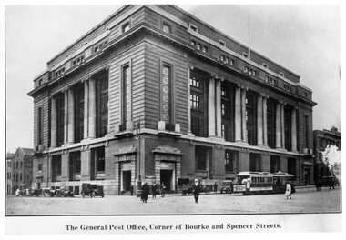
Photograph - Black and White - Mail Exchange Spencer and Bourke Streets c1920
Photo of the Mail Exchange Building with a cable tram loading prior to departure and a number of motor vehicles. The photo shows the monumental construction for the then Post Master Generals Department. This building was completed in 1917 to replace the mail sorting functions of the GPO on the corner of Bourke and Elizabeth St. It had tunnels that connected with Spencer Street Railway station opposite and was designed for the sorting and transporting of mail.Yields information about the Mail Exchange building.Photograph - Black and White - Mail Exchange Spencer and Bourke Streets c1920tramways, trams, cable cars, bourke street, spencer street, post office, post master general, mail exchange -
 Eltham District Historical Society Inc
Document - Survey Plan, Country Roads Board, SP 6800, Eltham-Yarra Glen Road; Bridge St to Henry St, 1958
1958 C.R.B. Plan of Survey of Part of Crown Portions 12 and 13 Section 4 Parish of Nillumbik, County of Evelyn Eltham-Yarra Glen Road., Shire of Eltham Shows Surveyor field notes, property ownership and building type and construction.1958, a.m. gahan, a.s & s.j. davis, annie ellen davies, bridge street, country roads board, d.a. lyon, dave lyon, eltham, flora towell, g.e. gallagher, henry street, j. lyon, k. greene, main road, p.a. gahan, survey plan, w.l. chynoweth pty ltd, york street, neil webster collection -
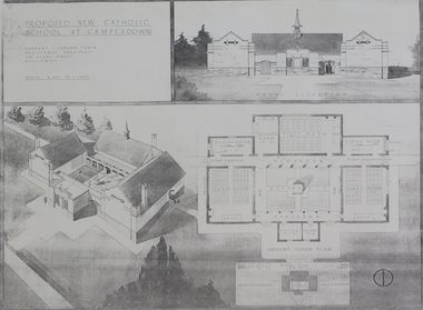 Federation University Historical Collection
Plan (copy), 'Proposed New Catholic School at Camperdown' by Herbert L. Coburn
Ballarat born Herbert L. Coburn grew up to be a renowned Ballarat architect, practising from 1905 to 1956. He taught Architecture and Building Construction at the Ballarat School of Mines (SMB) from 1918, resigning in 1948 due to ill health. Copy of a plan for a Catholic primary school at Camperdown by H.L. Coburn. The plan includes front elevation, ground floor and block plan.coburn, h.l. coburn, herbert l. coburn, architecture, camperdown, architectural plan -
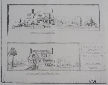 Federation University Historical Collection
Plan - Plan (copy), 'Design for Brick Residence Cnr Sturt and Russell St for K. Price Esq.' by Herbert C. Coburn, not dated
Ballarat born Herbert L. Coburn grew up to be a renowned Ballarat architect, practising from 1905 to 1956. He taught Architecture and Building Construction at the Ballarat School of Mines (SMB) from 1918, resigning in 1948 due to ill health.Photocopy of a plan by architect H. L. Coburnherbert l. coburn, coburn, h.l. coburn, k. price, architectural plan, russell street, ballarat -
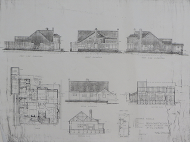 Federation University Historical Collection
Plan - Plan (copy), 'Brick cased Residence 1515 Sturt Street West for Mrs H.L. Coburn, by H. Leslie Coburn, not dated
Ballarat born Herbert L. Coburn grew up to be a renowned Ballarat architect, practising from 1905 to 1956. He taught Architecture and Building Construction at the Ballarat School of Mines (SMB) from 1918, resigning in 1948 due to ill health.Copy of a plan by H.L. Coburn. It includes a front, west, east and rear elevation; ground plan, block plan; and layout plan. herbert l. coburn, h.l. coburn, coburn, architecture, herbert coburn, architectural plan -
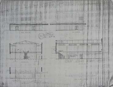 Federation University Historical Collection
Plans (copy), 'Proposed new Premises at Horsham for Paterson's Furniture Pty Ltd' by Herbert L. Coburn, not dated
Ballarat born Herbert L. Coburn grew up to be a renowned Ballarat architect, practising from 1905 to 1956. He taught Architecture and Building Construction at the Ballarat School of Mines (SMB) from 1918, resigning in 1948 due to ill health.Copy of 2 plans for a proposed double storey building at Horsham for Paterson's Furniture Pty Ltd.: .1) Ground and first floor plans .2) Elevationsherbert l. coburn, h.l. coburn, coburn, architecture, horsham, paterson's furniture pty ltd, architectural plan -
University of Melbourne, Burnley Campus Archives
Photograph - Black and white print, 4/3, 1947
"The erection of the new building for the School of Primary Agriculture & Horticulture was commenced late 1945 or early 1946 & proceeded slowly. It was sited on ground between the E.L.C. and the School Grounds. It was necessary to pull down about half the Pavilion to allow construction to proceed." THK"Erection of the new building for the School of Primary Agriculture & Horticulture . February 1947building, school of primary agriculture & horticulture, pavilion, e. m. gibson collection -
 Heidelberg Golf Club
Album - Photograph Album, Heidelberg Golf Club, HGC Clubhouse redevelopment 1998, 1998
Album containing about 186 color photographs of Heidelberg Golf Club's clubhouse redevelopment 1998, including 22 photos of old clubhouse; 94 photos of demolition and construction, 10 of landscaping after the building works and 60 of Opening Day celebrations.Album #6 in the photograph collection at HGCDark green hard cover album. Contains approx. 186 colour photographs 15x10cm.heidelberg golf club, clubhouse redevelopment 1998, club house opening 1998 -
 Vision Australia
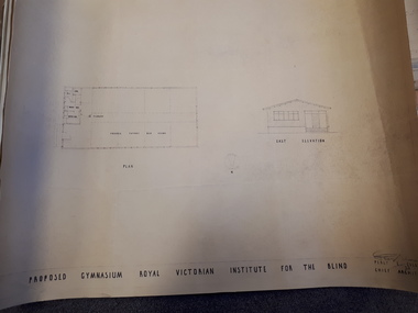
Plan - Image, Proposed Gymnasium Royal Victorian Institute for the Blind, 21 June 1950
In 1951 plans were made for the construction of a gymnasium to be situated in the grounds of St Kilda Road. These 4 plans specify the building construction notes, present front and east elevations, and show how part of the hall could be transformed into bedrooms in the future. There are 2 copies of each plan, consisting of identifical copies of the east elevation and different notes printed/handwritten on the front, side and top elevations. These were presented to the RVIB Board in Feburary 1951, according to the stamp on the back.2 architectural plans showing proposed gymnasium buildingPercy E Everett Chief Architectroyal victorian institute for the blind, plans -
 Bendigo Historical Society Inc.
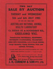
Document - IAN DYETT COLLECTION: AUCTION CATALOGUE - AUSTRALIAN NATIONAL ANIMAL HEALTH LABORATORY
Dark red covered auction catalogue with black printing for a sale on the 5th and 6th July 1983 at the Australian National Animal Health Laboratory, Geelong, Vic. For sale was Construction Materials, Equipment, Scaffolding, Transportable Site Buildings, G.F.C. False Work, and Large Quantity Piping Stainless Steel and Copper Fittings. J. H. Curnow & Son Pty. Ltd. Were the auctioneers.business, auctioneers, j h curnow & son pty ltd, ian dyett collection - auction catalogue - australian national animal health laboratory, john holland, j h curnow & son pty ltd, f c dyett, i m dyett, n f dyett, bolton bros pty ltd print -
 Hume City Civic Collection
Photograph, c 1974
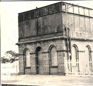
The mounted photograph is one of a series used for display purposes. The water tower at Sunbury Station was built in 1861 by J. Bett. it is of state significance and is an indicator of the importance of the railway to Sunbury's expansion in the Nineteenth Century. Steam trains needed sufficient steam power to climb the steep gradients over the Great Dividing Range and the water tower at Sunbury was used to replenish the trains' water supply for the remainder of the journey.A black and white photograph of the water tower at Sunbury Railway Station. The base of the tower is a brick construction with an arched doorway and two bricked in arched windows at either side of the doorway and a further two bricked in arched windows on the side. Above the base is a large square iron water storage tank with two downpipes at the side. There is a picket fence either side of the building. Mounted on board.sunbury railway station, water towers, victorian railways, bett, j., george evans collection -
 Melbourne Tram Museum
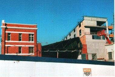
Photograph - Set of 3 Colour Print/s, Postcard, Steven Altham, 29/04/2002 12:00:00 AM
Set of 3 colour prints of the re construction of the Hawthorn Tram Depot to the Watermark Apartments. All taken on 29-4-2002 .1 - view from the west side looking at the original buildings, no front wall to the depot part and the new apartment block. .2 - ditto .3 - Looking at the west end of the new block and car park entrance, no tracks laid.All have details of photograph on rear and photographers name.trams, tramways, watermark apartments, hawthorn depot, construction, tram depot -
 Melbourne Tram Museum
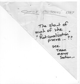
Document - Report, Metropolitan Transit Authority (MTA), "MTA Engineering & Maintenance Change Projects", 1987
Photocopied 140 page document titled "MTA Engineering & Maintenance Change Projects", produced by the MTA, 11/12/1987 setting out the proposal changes to MTA staff, use of contractors, consultation with the unions, consultation with unions, has a table of contents, index. Looks at construction activities, building maintenance and track maintenance, electrical and vehicle maintenance for the rail and tram divisions.trams, tramways, ptc, unions, tramways, railways, mta, workshops -
 Melbourne Tram Museum
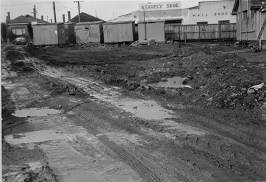
Photograph - Set of 4 Black & White Photograph/s, Melbourne & Metropolitan Tramways Board (MMTB), 1966
Series of 4 black and white photographs of the construction of three tracks or roads at East Preston Depot 7/1955. .1 - Mud mining - earthworks with the Stately Shoe and Wall Bros buildings in the view. .2 - showing one track complete with a second underway, .3 - two tracks complete with a third just in the view. .4 - pouring concrete at the depot - bicycle shed?trams, tramways, east preston, construction, trackwork, tram depot, track materials -
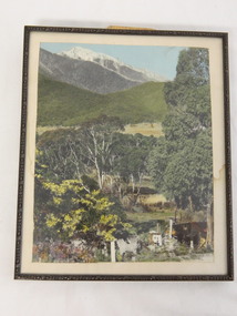 Kiewa Valley Historical Society
Photo Framed - Tawonga South, c1940's
Tawonga South was situated between the rural township of Tawonga and the State Electricity Commission of Victoria's construction town of Mt Beauty. The building in the fore ground of the photo was built before the Mt Beauty township was built as the occupier was working on the Kiewa Hydro Electric Scheme.The Barters came to work on the State Electricity Commission of Victoria's Kiewa Hydro Electric Scheme before housing in the town of Mt Beauty was built. The Barters rudimentary dwelling was probably not a legal building. The photo was taken by Vera Hore (nee Ryder), the publican at the Bogong Hotel near Tawonga South where the photo was taken. Vera, 1909 - 2000, was a keen amateur photographer.Colored photo of Tawonga South with a dwelling in the bottom of the right hand corner and Mt Bogong, covered in snow, at the top. Framed with cream card board 1 cm wide and a metal decorated frame surrounding it.On the back - "Vera Hore"tawonga south; vera hore; mt beauty -
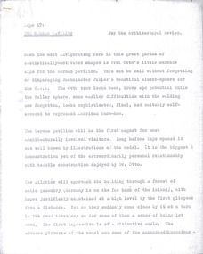 Robin Boyd Foundation
Document - Manuscript, Robin Boyd, Expo ’67: The German Pavilion, 1967
Boyd discusses the German Pavilion at Expo 67, designed by Frei Otto. He gives a detailed description of its construction, components, structural system and building challenges. This manuscript published with the title ‘Germany’ in 'Architectural Review', Vol 142, No 846, July 1967. Original manuscript of an article published as ‘Germany’ in Architectural Review, 'Architectural Review', Vol 142, No 846, July 1967, pp 129-135.Typewritten (p/copy), quarto, 7 pagesexpo 67, german pavilion, frei otto, matched structures, tensile structures, compressive structures, prehensile structures, mesh, membrane structures, robin boyd, manuscript, ohm2022, ohm2022_31 -
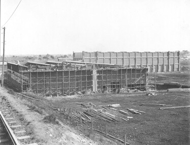 Melbourne Tram Museum
Photograph - Preston Workshops Construction Store and Paint Shop, Sutcliffe Pty Ltd, c1925
Black and white photograph of the construction of the Preston Workshops store building c1926 with the Paint Shop behind. Photo taken from the railway line looking west. Shows the scaffolding for the brick walls being completed. Photo by Sutcliffe Pty Ltd on behalf of the MMTB.Yields information about the then new Preston Workshops being built.Black and white print with photographer's detail on the rear."Sutcliffe" photographers stamp.tramways, construction, buildings, preston workshops -
 Greensborough Historical Society
Photograph Album, Diamond Valley Community Hospital. Redevelopment Program 1990/91. Vol 1, 06/03/1990
The Diamond Valley Community Hospital was established in 1942 in Grimshaw Street Greensborough. This album records the redevelopment/building program in 1990-1991, and includes functions such as 'Turning the Sod' and many photos of buildings under construction. Due to financial circumstances, the hospital closed in 2000. This collection of photo albums is from the 1990s and was collected by staff. Photographs include staff, patients, buildings and functions held for the hospital. Photographs are not named. Albums may be accessed at the GHS Resource Centre. This volume is numbered 6. As the Diamond Valley Community Hospital is now closed, this collection of albums records some of the people involved. Many of the old hospital buildings in Grimshaw Street are still in use as medical rooms and it is interesting to see them being built in 1990.Photo album with dark blue cover. 56 pages, 253 photographs of varying sizes. Title handwritten and pasted on front cover.diamond valley community hospital, greensborough, dvch -
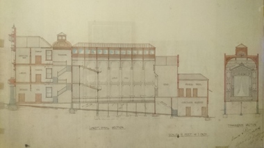 Unions Ballarat
Plan - Photograph: Trades Hall building architects' design, 1886
Original architects' drawings for the construction of Trades Hall, Ballarat. November 5th 1886 the building committee called for tenders for the erection of a Trades Hall on the following conditions. The amount to be expended to be no more than £3,000; bluestone foundations; the front of the building to be of Grampians freestone and walls of brick. Building to be 3 storeys high, containing 14 rooms with a hall capable of seating 600 persons, roof to be of slate and workmanship and material to be of the best quality. The design submitted by Messrs James and Piper was accepted subject to amendment.Relevance to the history of Trades Hall, Ballarat.Paper - architects' plans.btlc, ballarat regional trades and labour council, ballarat trades and labour council, ballarat trades hall, eight hours anniversary committee, james and piper, architects' drawings, building -
 Federation University Historical Collection
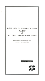
Programme, Release of Technology Park Plans and Laying of Foundation Stone, 1995, 02/1995
The Ballarat Technology Park site consists of 28.8 hectares of freehold land zoned for technology Purposes. The development plan for the Park was prepared by the City of Ballarat. The construction of the ISSC Southern Regional Data Centre was the first stage of the project. ISSC Southern Regional Data centre is a $12.5 million building development at the corner of Geelong Road and gear Avenue. The building was constructed by H. Troon Pty Ltd. White card program for the Release of Technology Park Plans and Laying of Foundation Stone. ballarat technology park, issc southern region data centre, troon, david james, geoffrey blainey, bruce clark, john bligh, roger hallam, campus plan -
 St Kilda Historical Society
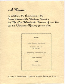
Ephemera - Menu, A Dinner to Celebrate the Launching of the Final Stage of the National Theatre, 1973
Contains information about the formation and growth of the National Theatre Movement and statistics about the construction of the new National Theatre in the building formerly known as the Victory Theatre, on the corner of Carlisle and Barkly Streets, St Kilda. A dinner to launch the final stage of construction was held on 4 December 1973. Completion was planned for 15 June 1974 and the official opening date was to be 24 August 1974. The dinner was hel at the Stardust, Marine Parade, St Kilda and was hosted by the Victorian Ministry for the Arts.Yellow coloured card printed in black on one side and brown on the othernational theatre, stardust -
 Kew Historical Society Inc
Plan, Melbourne & Metropolitan Board of Works : Borough of Kew : Detail Plan No.1575, 1905
The Melbourne and Metropolitan Board of Works (MMBW) plans were produced from the 1890s to the 1950s. They were crucial to the design and development of Melbourne's sewerage and drainage system. The plans, at a scale of 40 feet to 1 inch (1:480), provide a detailed historical record of Melbourne streetscapes and environmental features. Each plan covers one or two street blocks (roughly six streets), showing details of buildings, including garden layouts and ownership boundaries, and features such as laneways, drains, bridges, parks, municipal boundaries and other prominent landmarks as they existed at the time each plan was produced. (Source: State Library of Victoria)This plan forms part of a large group of MMBW plans and maps that was donated to the Society by the Mr Poulter, City Engineer of the City of Kew in 1989. Within this collection, thirty-five hand-coloured plans, backed with linen, are of statewide significance as they include annotations that provide details of construction materials used in buildings in the first decade of the 20th century as well as additional information about land ownership and usage. The copies in the Public Record Office Victoria and the State Library of Victoria are monochrome versions which do not denote building materials so that the maps in this collection are invaluable and unique tools for researchers and heritage consultants. A number of the plans are not held in the collection of the State Library of Victoria so they have the additional attribute of rarity.Original survey plan, issued by the MMBW to a contractor with responsibility for constructing sewers in the area identified on the plan within the Borough of Kew. The plan was at some stage hand-coloured, possibly by the contractor, but more likely by officers working in the Engineering Department of the Borough and later Town, then City of Kew. The hand-coloured sections of buildings on the plan were used to denote masonry or brick constructions (pink), weatherboard constructions (yellow), and public buildings (grey). Plan No.1575 shows that in the area bounded by Wellington Street, Edgevale Road, Glenferrie Road, and Cotham Road, there had already been significant subdivision of land and houses constructed. As one of the highest points in Kew, as expected, there were already some significant mansions built on large allotments of land. Many of these mansions are identified by name on the plan such as ‘Kelso’, ‘Abbotsford’, ‘Clarendon’ and ‘Ashlyn’ in Cotham Road. Other houses of equal size are unnamed on the plan.melbourne and metropolitan board of works, detail plans, maps - borough of kew, mmbw 1575, cartography -
 Eltham District Historical Society Inc
Document - Survey Plan, Country Roads Board, SP 6561, Eltham-Yarra Glen Road; Park Rd to Bellevue Rd, 1957
1957 C.R.B. Plan of Survey of Parts of Crown Allotment 1 & Crown Allotment F, Section II Parish of Nillumbik, County of Evelyn Eltham-Yarra Glen Road, Shire of Eltham Shows Surveyor field notes, property ownership and building type and construction.eltham-yarra glen road, country roads board, eltham, main road, survey plan, 1957, a.r. thomas, b. & b.d. hearn, b.g. anderson, bellevue road, e.m. pitts, f.a. m. macrae, g.e. & b. moulder, j. bromley, j.m. & s.g. johnstone, k.f. pitts, l.c. docksey, m. & e.c.w. baart, m.p. bromley, n.r. ord, p.j. & g.e. murphy, park road, r.a. bruce, r.a. macbeth, r.w. shearing, railway road, s.e. & y.p. houghton, w.k. bell, w.s.r. & f.n. toley, neil webster collection -
 University of Melbourne, Burnley Campus Archives
Photograph - 35mm Colour slides, Miscellaneous, 1969-1987
1. "Hockey 1969 R. Hamley Foreground" Jul 69. 2-5. "Clearing Tech Block Site" Jul 69. 6. Garden view Dec 75. 7. "Nursery Block from College Building" (roof) Mar 77. 13-14 slides garden beds in front of Administration Building Sep 81. Garden view Feb 87.23. "Wide World of Gardening' display Mar 86. 17-19 View towards Plant Research Institute. 15-16, 21-22 Construction New Library. hockey, 1969, r. hamley, tech block site, garden views, garden beds, administration building, nursery block, wide world of gardening display, construction new library, plant research institute