Showing 2044 items
matching building and construction
-
 Kew Historical Society Inc
Plan, Melbourne & Metropolitan Board of Works : Borough of Kew : Detail Plan No.1568, 1905
The Melbourne and Metropolitan Board of Works (MMBW) plans were produced from the 1890s to the 1950s. They were crucial to the design and development of Melbourne's sewerage and drainage system. The plans, at a scale of 40 feet to 1 inch (1:480), provide a detailed historical record of Melbourne streetscapes and environmental features. Each plan covers one or two street blocks (roughly six streets), showing details of buildings, including garden layouts and ownership boundaries, and features such as laneways, drains, bridges, parks, municipal boundaries and other prominent landmarks as they existed at the time each plan was produced. (Source: State Library of Victoria)This plan forms part of a large group of MMBW plans and maps that was donated to the Society by the Mr Poulter, City Engineer of the City of Kew in 1989. Within this collection, thirty-five hand-coloured plans, backed with linen, are of statewide significance as they include annotations that provide details of construction materials used in buildings in the first decade of the 20th century as well as additional information about land ownership and usage. The copies in the Public Record Office Victoria and the State Library of Victoria are monochrome versions which do not denote building materials so that the maps in this collection are invaluable and unique tools for researchers and heritage consultants. A number of the plans are not held in the collection of the State Library of Victoria so they have the additional attribute of rarity.Original survey plan, issued by the MMBW to a contractor with responsibility for constructing sewers in the area identified on the plan within the Borough of Kew. The plan was at some stage hand-coloured, possibly by the contractor, but more likely by officers working in the Engineering Department of the Borough and later Town, then City of Kew. The hand-coloured sections of buildings on the plan were used to denote masonry or brick constructions (pink), weatherboard constructions (yellow), and public buildings (grey). Plan No.1568 covers the area bounded by Cotham Road, John Street, Sackville Street, and Edward Street. Alfred Street and Rowland Street are in shown in the middle of the plan. The two most notable buildings shown are ‘St Helliers’, the home of the Dumaresq family, and St Hilary’s Church and school. While the colours used to indicate St Hilary’s are grey as in other civic/public buildings, the first St Hilary’s Anglican Church was at this stage constructed in weatherboard. At the left of the plan, facing Sackville Street is a house named ‘Glencara’. The 1988 ‘Kew Conservation Study’ recorded that “The first documentary evidence of this house comes from Rate Books which record that in 1893 a Mrs Treadway was the owner of this building with an N.A.V. of £81? At that date the occupier of the house was Charles B. Kelly, a clerk, while by 1910 Kelly had become the owner of the property described in that year ‘as a six-roomed stone, brick and wood house with stables and outbuildings’”. Contrary to this description, the 1905 plan indicates that the house was entirely constructed of masonry.melbourne and metropolitan board of works, detail plans, mmbw 1568 -
 Kew Historical Society Inc
Plan, Melbourne & Metropolitan Board of Works : Borough of Kew : Detail Plan No.1573, 1905
The Melbourne and Metropolitan Board of Works (MMBW) plans were produced from the 1890s to the 1950s. They were crucial to the design and development of Melbourne's sewerage and drainage system. The plans, at a scale of 40 feet to 1 inch (1:480), provide a detailed historical record of Melbourne streetscapes and environmental features. Each plan covers one or two street blocks (roughly six streets), showing details of buildings, including garden layouts and ownership boundaries, and features such as laneways, drains, bridges, parks, municipal boundaries and other prominent landmarks as they existed at the time each plan was produced. (Source: State Library of Victoria)This plan forms part of a large group of MMBW plans and maps that was donated to the Society by the Mr Poulter, City Engineer of the City of Kew in 1989. Within this collection, thirty-five hand-coloured plans, backed with linen, are of statewide significance as they include annotations that provide details of construction materials used in buildings in the first decade of the 20th century as well as additional information about land ownership and usage. The copies in the Public Record Office Victoria and the State Library of Victoria are monochrome versions which do not denote building materials so that the maps in this collection are invaluable and unique tools for researchers and heritage consultants. A number of the plans are not held in the collection of the State Library of Victoria so they have the additional attribute of rarity.Original survey plan, issued by the MMBW to a contractor with responsibility for constructing sewers in the area identified on the plan within the Borough of Kew. The plan was at some stage hand-coloured, possibly by the contractor, but more likely by officers working in the Engineering Department of the Borough and later Town, then City of Kew. The hand-coloured sections of buildings on the plan were used to denote masonry or brick constructions (pink), weatherboard constructions (yellow), and public buildings (grey). This plan has detailed annotations written in red or blue ink, showing prices, which may be the annual valuations of the properties, and some owners’ names, a most unusual feature on contractor's maps. Some areas, such as the buildings of Methodist Ladies’ College (MLC), include the school’s tennis court and swimming pool, but are not coloured to show building materials – did the draftsman just run out of time, or ink, or enthusiasm, before his plan had to be submitted? MLC had been founded in 1882 as a ‘modern school of the first order’ with buildings that formed ‘a collegiate institution for girls unsurpassed in the colonies’. The goal of its founders was to provide a high-class Christian education for girls, comparable with that provided elsewhere for boys. Some shops are shown along Edgevale Road, though they are not designated as commercial premises. Larger houses are depicted, including ‘Fairlawn’ in Barkers Road, and ‘Clevedon’ and ‘Rosehill’ (now demolished) in Fitzwilliam Street.melbourne and metropolitan board of works, detail plans, mmbw 1573, maps - borough of kew, cartography -
 Eltham District Historical Society Inc
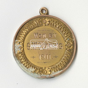
Medallion, Won by G.W. Gunning, 1911; N.G.C., Presented by J.R. Hutchinson, 1911
Found during demolition of 'lean to' additions to Eltham Primary School Dalton Street building of mud stone 1875 construction during alterations, 21 September 1994. Paint appears to have dripped through onto medallion found on floor bearer 4" x 3"Round medallion, brass with paint on surfaces, approximately 25mm diameter and small eyelet at top for chain attachment or similar eltham primary school, eltham state school, g.w. gunning, j.r. hutchinson, medal, n.g.c., renovation, state school no. 209 -
 Federation University Historical Collection
Document, Open House at Mt Helen for Civic Leaders, 1972, 03/1972
Ballarat Institute of Advanced Education (BIAE) was the tertiary division of the Ballarat School of Mines. The 240 acre Mt Helen campus was purchased in 1967. In 1972 a four storey library, union building and hall of residence for 70 students were under construction at an approximate cost of $2,500,000.Orange four page outline of an open house designed to give civic leaders a glimpse into the new campus at Mount Helen that was opened in 1970.ballarat institute of advanced education, mount helen campus, ballarat school of mines -
 Bendigo Historical Society Inc.
Document - Newspaper Articles from Bendigo Advertiser
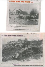
In 1867, Frenchman Joseph Monier patented the use of metal reinforced concrete for use in horticultural troughs. Francois Hennebique expanded this idea into a general construction technique including for the construction of bridges bridges with the first bridge built in 1875. In Victoria, Monash and Anderson, representatives of the Australian patent holders and later Victorian patent holders. The Bendigo Monier Bridges were built between 1901 and 1902. Monash's contribution was not in the actual technology but in the promotion and defence of the new technology that was faced by much doubt and scepticism.Series of Bendigo Advertiser articles on the theme of Monier Bridges. Five articles from "Discover Bendigo" by James Lerk. 1999 One article from "History Lives" by Jim Evens titled 'Building History Bridges" 2014 Two black and white photos from "The Way we Were" featuring the construction of the Booth Street Bridge 2014 and the collapse of the King Street bridge 2015.monier bridges, engineering -
 Bendigo Historical Society Inc.
Slide - RALPH BIRRELL COLLECTION: APPLIED SCIENCE BUILDING LATROBE, c1965-1976
Bendigo Institute of Technology ENG School - Dr Ralph Birrell Collection c1956-1976. Construction of the Applied Science Buildings at Latrobe University. Cleared ground, piping and truck in view. Markings slide marked number 6 May '69. Made in Australia. Processes by Kodak, Kodachrome Transparency. Folder 72 stored in Box 750 Row 3 Bay 3 Shelf 3Kodakeducation, tertiary, latrobe university bendigo, ralph birrell latrobe university construction -
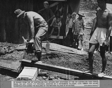 National Vietnam Veterans Museum (NVVM)
Photograph, Ap Sui Nge Refugee Village
A black and white photograph of A Digger from 1st Australian Civil Affairs Unit stationed at 1st ATF Base in Phuoc Tuy Province assisted by a villager cuts timber for house construction during the building of the Ap Sui Nge Refugee Village. The village was designed by the officers and men of the 1st Australian Civil Affairs Unit and built as a major project involving Task Force Unitsphotograph, 1st australian civil affairs unit, 1st atf base, phuoc tuy province, ap sui nge village, gibbons collection catalogue, digger -
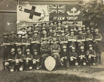 Kew Historical Society Inc
Photograph, 1st Kew Scout Troop with the Cohen Shield, c.1922
The 1st Kew Scouts was one of the first Scout Troops in Victoria, being formed in 1909. From 1927 they met in a magnificent Scout Hall in Disraeli Street, Kew until it was demolished in 1993. Still operating (in 2020) from their new Scout Hall on the corner of Kilby Road and Kellett Grove, Kew.Large group photo, mounted on card, of 1st Kew Scouts in uniform. The group of thirty-seven Scouts and two leaders (probably R.J. Poewrie SM and R. Wall ASM) are posed with a shield, likely to be the ‘Cohen Shield’, awarded at a statewide Scoutcraft competition for ‘Champion Troop of Victoria’. This was won by 1st Kew in 1922. The building in the photo is not the Disraeli Street Hall, which was a weatherboard construction.1st Kew Troop cohen shield, 1st kew scout troop, kew - scouts -
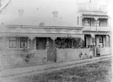 Surrey Hills Historical Society Collection
Photograph, 'Maitland', 1 Bedford Avenue, Surrey Hills, c 1900, 1900
Maitland' was built in 1889 for Thomas Zeplin, who was a Professor of Music. He owned all the land bound by Union Road, Wilson and Montrose Streets and the railway line. 1 Bedford Avenue stayed in family ownership until purchased by Camberwell Council in 1986, initially for a car park. However it was renovated to become part of Surrey Hills Neighbourhood Centre. It was opened on 23 November 1990. No 3 Bedford Avenue was built for Thomas Zeplin's daughter and named 'Mervyl' or 'Merryl'. Mrs Brodecky (donor) was the great-granddaughter of Thomas Zeplin. The 2 girls are granddaughters of Thomas Zeplin. Electoral roll information: 1972 & 1977: Albert Vojteck Brodecky, manager, 1 Bedford Avenue. 1977: Ray Nanette Brodecky. There are 2 copies. Thomas had this built for his son and family. The house was occupied by his family, though sometimes rented out. His great-grand-daughter Mrs. A. Brodecky sold to the Camberwell Council in 1986. This was the only surviving photo in the family after the fire. Courtesy: Mrs. A. BrodeckyBlack and white photo of 2 houses taken from the street front. On the LHS is a Victorian double-fronted single-storey villa of Hawthorn brick construction, with wrought iron lacework to the veranda, slate roof and picket fence, with an established garden. Next door at No 3 is a double-storey Victorian terrace with a similar fence and building materials. There are 2 young girls standing in front between the properties.maitland, bedford avenue, 1900, surrey hills neighbourhood centre, victorian style, mervyl, merryl, mr thomas zeplin, mrs nanette brodecky, mr albert vojteck brodecky -
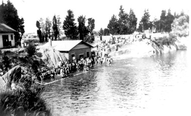 Surrey Hills Historical Society Collection
Photograph, The Surrey Dive, January 1931, 1931
The Surrey Dive was formed on the site of a quarry from which clay had been extracted for brick-making. From 1905 Council was petitioned by the newly-formed Surrey Park Swimming Club to develop the site. Improvements including bathing sheds, spring boards and a 10-lane course but it remained a challenging site for inexperienced swimmers because of the sheer cliffs and the drop of 30m. The dive was the site of many swimming carnivals and attracted large spectator crowds. Frank Beaurepaire competed in the first carnival held in 1907 and won the one-mile race in record time. The dive was closed following the drought of 1967-1968 and redeveloped as an ornamental lake.The Surrey Dive was the first Olympic standard pool in Australia. Black and white photo of the Surrey Dive taken in January 1931, probably during a swimming carnival. The dive is in the foreground with 2 buildings on the LHS. One is brick with a chimney and at the water's edge; the other is of timber construction and is on the far LHS on the bank above the water. There is a large group of people in bathing costumes and a crowd which extends up the bank towards the right. There are mature conifer trees in the background. surrey dive, swimming, sports and recreations, ron falconer -
 Melbourne Tram Museum
Slide - Set of 2, Keith Caldwell, Mar. 1960
Agfa Colour slide, cardboard mount, by Keith Caldwell of:- .1 - Y class 469 leaving the Batman Ave terminus, to Wattle Park Elgar Road. Has a small advert for radio station 3AW - Instant News. .2 - Y1 class 611 ditto, to Burwood. Has Pimms No. 1 cup advert on the front of the tram. In both photos, buildings under construction can be seen.hand stamped Mar '60" .1 has "Batman 3/60" in ink and .2 "BXAM" in ink on the slides.trams, tramways, batman ave, y class, y1 class, wattle park, burwood, tram 469, tram 611 -
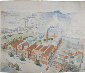 Federation University Historical Collection
Painting - Artwork Plan, Birdseye View of the Ballarat School of Mines, 1915, 1915
Herbert Leslie (Les) COBURN (1891-1956) Australia This work was commissioned by the SMB Council to hang in its chambers. It envisions the new Junior Technical School building and was illustrated in the same year the Ballarat Technical Art School building officially opened. Les Coburn was a student at the Art School between 1908 and 1916. Coburn and his business partner, Percival Selwyn Richards (1865-1952), became joint instructors in architecture and building construction at the school from 1920, with Coburn continuing until 1948. Watercolour plan drawing on paper of Ballarat School of Mines showing the Museum, Administration building, Technical Art School, and proposed Junior Technical School, Ballarat School of Mines Botanical Gardens, and the Ballarat Gaol Governor's Residence. ballarat school of mines museum, ballarat technical art school, ballarat junior technical school, watercolour, cr. h. l. coburn, aerial, ballarat school of mines, birdseye view, h.l. coburn, herbert leslie coburn, les coburn -
 Eltham District Historical Society Inc
Document - Survey Plan, Country Roads Board, SP 6559-6560, Eltham-Yarra Glen Road; Elsa Ct to Luck St, 1957
1957 C.R.B. Plan of Survey of Part of Crown Portion 13 Section 4 and Crown Allotment 1 Section 1 Parish of Nillumbik, County of Evelyn Eltham-Yarra Glen Road, Shire of Eltham Shows Surveyor field notes, property ownership and building type and construction.eltham-yarra glen road, country roads board, eltham, main road, survey plan, 1957, a.m. & a.a. iowerson, a.mcg. hepburn, cecil street, coffee lounge, diamond street, e.g. murrell, elsa court, h.b. woodhead, j.c. & s.i. harding, la ronde, luck street, r.m. & v.m. white, r.n. mowatt, the board of land & works, w.g. hains, neil webster collection -
 University of Melbourne, Burnley Campus Archives
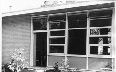
Photograph - Black and white print, Canteen & Recreation Room, 1961
Note by T.H. Kneen 19 November 1991, "Canteen & Recreation Room built by P.W.D. (Public Works Department) with funds provided by Burnley Horticultural College Ladies' Committee (in 1962?). The paving was carried out by students under direction of George Grumont." (Mechanics, Carpentry and Building Construction).Black and white photograph. Canteen and recreation room.canteen, recreation room, george grumont, burnley horticultural college ladies' committee, students working outside, public works department, paving -
 Federation University Historical Collection
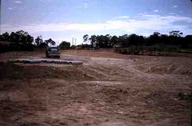
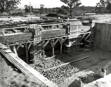
Photograph, N.l. Harvey & Son, Mount Helen Campus, 1968, 1969
The Federation University campus at Mount Helen was first used by students in 1970.Seven photographs of the Mt Helen Campus Stage one development. .1) Aerial view of foundation work, from west, towards Green Hill .2) Aerial View from South. Earthworks and foundations .3) Aerial View from south west. Earthworks, general view .4) Aerial View from above the South West corner of E building. .5) Aerial View from North East. Gear Avenue in background .6) Aerial View from North West. Earthworks extend from Gear Avenue .7) Ground level view. First columns of E building. .13) Mt Helen development Stage One, Engineering Diploma Buildings. This image shows the wall beam and pier construction to the East Wall of the Fluid Mechanics Laboratory adjacent to the pump chamber, 17 June 1968. .18) Flume Pit and Pump Chamber, 15 July 1968. .28) East Wing Pit Looking North, 26 August 1968 .40) Construction as of 04 November 1968federation university, federation university australia, feduni, university of ballarat, ballarat college of advanced education, ballarat institute of advanced education, building, earthworks, foundation, early development, soil testing laboratory -
 Eltham District Historical Society Inc
Photograph - Colour Print, Eltham Shire Council, Unidentified road, Eltham district, c.Oct. 1987
Date based on other similar display panels visible in images of the Shire of Eltham display at the Eltham Community Festival, 7 November 1987. 20 x 25 cm Shire of Eltham Engineering Department Providing the resources to undertake • Survey, design, consultation • Road construction and maintenance • Bridge construction and maintenance • Street sweeping • Drain and pit cleaning • Traffic engineering installation and maintenance • Garbage collection • Tip management, land reclamation and beautification • Maintenance of community buildings • Provision of community and recreation facilitiesunidentified, display panel, eltham festival, footpaths and gutters, infrastructure, residential, roads, shire of eltham, streets, 1987 -
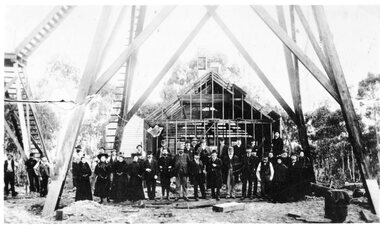 Stawell Historical Society Inc
Photograph, Kinsella Family Lubeck, Cahill Mine Stawell c1896, 1896
Cahill Reward Gold Mine Company. Building still under construction c 1896 closed 1901. Thomas Kinsella had photo. In 1907 the Pleasant Creek Alluvial Mining Company reused the shaft digging down to 200 feet to work the ground and sank a second shaft nearby.Group of people standing under Poppet Head in front of partially constructed Engine House -
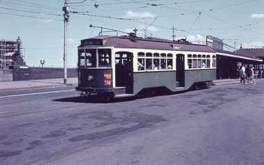
 Melbourne Tram Museum
Postcard, Murfett Publishers, W2 509 outbound in Wellington Parade Melbourne, early 1980's
Postcard - full colour, Divided back type of W2 509 outbound in Wellington Parade Melbourne. Two other trams are in the view. Tram has the destination of Kew Depot and route 29. In the background is a hoarding for the construction of the Melbourne Underground loop - indicates the photo taken late 1970's or early 1980's. Note the building on the corner of Spring and Flinders St, prior to the construction of Shell House mid 1980's. Note at this time Wellington Parade was only available for through motor traffic out of the city. published by National View by Murfett Publishers Australia. Has the details on the rear with place for stamp, address etc and logo.trams, tramways, wellington parade, kew depot, route 29, spring st, flinders st, tram 509 -
 Kiewa Valley Historical Society
Photograph Transmission lines Mount Beauty, 66 KVA Transmission lines from Clover Power Station, Circa 1950
This photograph is a "snap shot" in time circa 1950s detailing the rural environmental change and the progressive effects of the Kiewa Valley Hydro Scheme on the basic rural setting of the valley (note the sparsity of rural infrastructure). This photograph shows the beginning of the accommodation and administration buildings for use by the construction workers and auxiliary administration employees of the Victorian State Electricity Commission. It also provides a view of the landscape before extensive development of Pondage and other non rural buildings.This photograph details a dramatic period in time which saw an enormous change to the exclusively rural area of the Kiewa Valley region in the mid 1900s (see sparse rural buildings/houses). This change presented both physical and mental challenges to the existing quiet rural inhabitants of the valley. The State of Victoria had to make adjustments to the changing demands imposed by population and industrial expansions. The development of cleaner energy supplies to a growing population has its downside ,which ever way the intrusion into the "natural" landscape is made. The construction of the large Pondage at the centre of the photograph is a good example.This black and white photograph of a panoramic view of the Kiewa Valley (Mount Beauty SEC construction workers village) shows the newly completed transmission line towers delivering electrical power(66KVA) from the Clover Power Station. The photo is on 200gms paper and not on special photographic paper.mount beauty 1940 to 1950s, development of sec kiewa hydro scheme, sec victoria -
 Tatura Irrigation & Wartime Camps Museum
Photograph, Camp 13 Hospital, 1956
Photos taken by Col McTaggart engaged in the removal of the original Camp 13 hospital building after the occupation of the camp by the State Rivers & Water Supply Commission Construction Branch c.1956. The building, bought by Mr. Henry, was transported to Corop in three sections, the high central section now a private residence located on the cnr. Midland Highway and Lake Cooper Road, the two outer sections converted to a house in Lake Cooper Road.Black & White, two A4 sized photos of Camp Hospital.tatura, camp 13 hospital, german pows, corop, photography, photograph, slides, film -
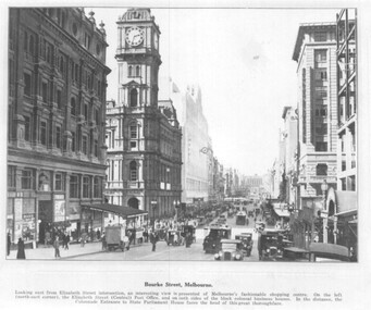 Melbourne Tram Museum
Photograph - set of 3 Black and White photographs, Tramway Museum Society of Victoria (TMSV), c1975
Series of three Black & White Photographs of a postcards made by the TMSV Sales of: .1 - Bourke St, looking east with the GPO in Elizabeth St in the view, along with many vehicular traffic - has the Myer building. c1920? .2 - Bourke St looking west from Swanston St prior to the construction of the Myer building. c1910. Has a number of horse drawn vehicles in the view and one motor car. Coles Book arcade on the south side. .3 - Similar to .1, but c1910 - has L Cohen & Co, Tailors and Outfitters. in the view. All views have cable trams in the view.trams, tramways, bourke st, elizabeth st, gpo, cable trams -
 Federation University Historical Collection
Photograph - Black and White Photographs, Views of Mount Helen Campus, c1973
Ongoing photgraphic record of Mount Helen Campus development. A contract for the construction of Student housing, Union building (later Albert Coates Complex), and a four storey library (later E.J.. Barker Library) on the Mt Helen campus was signed in November and December 1971. They were all completed and occupied in 1973. Views of Mount Helen Campus .1) Signposts of first turnoff campus road from Gear Avenue .2) Mount Helen Student Residences (stage 1) .3) Rear view of Mount Helen Student Residences (Stage 1)mount helen campus, buildings, student residences -
 Eltham District Historical Society Inc
Photograph, Hugh Fisher, Eltham Fire Station, east side of Main Road, 1950s, 1950s
The Eltham Fire Station was opened in 31 April 1935. Years later the building was removed and erected for use of 1st Research Scout Group in Research Park by the early 1970s to make way for the Eltham Village Complex which was under construction by 1971. The Research Scout Hall was destroyed by fire in 2002.Black and white photographPhoto by Hugh Fischer, c.1950seltham, fire station, main road -
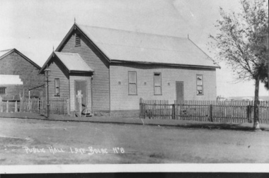 Lake Bolac & District Historical Society
Photograph - Black and white photograph, Lake Bolac Public Hall 1896, 1896
Lake Bolac Public Hall, Mongomery Street in 1896. Weatherboard construction by Mr Ollie Anderson of Ararat. Opened by district MP Mr McLellan. In 1922 this building was relocated across Montgomery Street to become the supper room for the newly erected Memorial Hall honouring World War 1 soldiers.black and white photographlake bolac, public hall, montgomery street, ollie anderson, mr mclellan -
Federation University Historical Collection
Book, Ballarat Technical Art School Register, 1955-1971, 1955-1971
The Ballarat Technical Art School (No. 10) was a division of the Ballarat School of Mines. Green ledger with black spine. Lists Student Number, Name, Trade or Occupation, Age at Last Birthday, Address, Date of Joining the School, Course Work. Courses listed include dressmaking, Elementary Art, Ticket Writing, Shorthand, Drawing, Pottery and Drawing. Pottery, Millinery. Junior Art, Building Construction, Matriculation Art, Needlework, Painting, Life Class, Decorative Needlework, General Art Course, Sculptureballarat technical art school, art general register, student enrolments, alumni, art studies, ballarat school of mines -
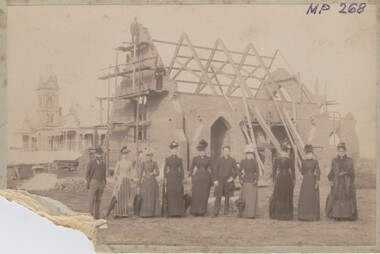 Bendigo Historical Society Inc.
Photograph - CHRIST CHURCH, SWAN HILL, 3rd May, 1882
Sepia photograph of Christ Church, Swan Hill showing construction materials. Group of eight women, two men, two men on scaffold. Larger building in background. On back: stamped in circle 'Royal Hiostorical Society of Victoria, Bendigo Branch', Indian ink: 'Church, Swan Hill, May 3rd, 1892. IG Alexandra Harris Incumbent'. Black ink' 'MP 268'. Previous Acc. No. 'MP 268'buildings, church, christ church, swan hill -
 Ballarat Tramway Museum
Photograph - Digital image, W. J. Llewelyn, c1955
Set of two colour digital images taken by W. J. Llewelyn. .1 - Armstrong Street from the Town Hall tower - shows the street view, car parking arrangements prior to the construction of the Ballarat City Hall, c1955. The new Civic Hall was opened in 1956. Shows the railway timber yard. .2 - Sturt St showing Town Hall and the Myers building late 1950's? trams, tramways, armstrong st, railway, town hall, myers -
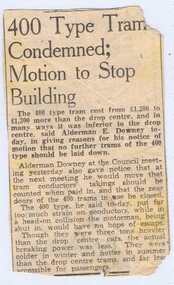 Ballarat Tramway Museum
Newspaper, "400 Type Tram Condemned; Motion to Stop Building", c1939
Newspaper cutting, titled "400 Type Tram Condemned; Motion to Stop Building" about the perceived problems of Brisbane's then new 400 class trams, compared to the older drop centre trams - complaints by an Alderman of the City Council - cost more and other problems - Construction of tram 400 was in 1938, so cutting could be in the period 1938 to 1940. Record revised and image added 20/9/2013.trams, tramways, brisbane trams, drop centre trams, 400 class