Showing 614 items
matching house sales
-
 Wodonga & District Historical Society Inc
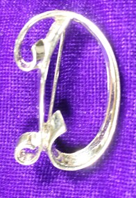
Decorative object - Silver initial brooch from the Sarah Coventry Collection, c. 1970s - 1980s
Sarah Coventry Pty. Ltd. was a North American jewellery company that was established in 1949 by the Stuart family as part of Emmons Jewelry, Inc. It began operations in England and Australia in 1968, and in Australia it moved from Carlton in Melbourne to Wodonga in 1969. The premises were originally on High St. in Wodonga, but a new warehouse was built in Melbourne Rd. later in 1969. It was a direct selling jewellery business using a party-plan model similar to Tupperware and Avon. The sales reps or 'Hostesses' were provided with jewellery samples in demonstration kits, which they displayed at jewellery parties in their homes. The designs for jewellery such as brooches, necklaces, earrings, chokers and bracelets were purchased from freelance designers and jewellery manufacturers rather than in-house designers. In 1979 Sarah Coventry Pty. Ltd. in Wodonga was bought by three Australian businessmen, including Wodonga local Jim Sawyer, and continued to sell jewellery under the name "Sargem Pty. Ltd”, for several more years in the 1980s.As part of the Sarah Coventry collection, the brooch has local significance with the decentralised commercial development of regional centres such as Wodonga in NE Victoria, as well as national and international significance from the perspective of social and economic developments for women after World War II. The direct selling party-plan business model Sarah Coventry was based on is also considered the first of its kind for jewellery.Silver plate Sarah Coventry brooch shaped as a letter Dsarah coventry, jewellery, wodonga, costume jewellery, vintage fashion jewellery, brooch, brooches, sawyer -
 Wodonga & District Historical Society Inc
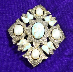
Decorative object - Vintage Sarah Coventry large silver tone brooch with turquoise coloured and faux pearl stone, c. 1970s - 1980s
Sarah Coventry Pty. Ltd. was a North American jewellery company that was established in 1949 by the Stuart family as part of Emmons Jewelry, Inc. It began operations in England and Australia in 1968, and in Australia it moved from Carlton in Melbourne to Wodonga in 1969. The premises were originally on High St. in Wodonga, but a new warehouse was built in Melbourne Rd. later in 1969. It was a direct selling jewellery business using a party-plan model similar to Tupperware and Avon. The sales reps or 'Hostesses' were provided with jewellery samples in demonstration kits, which they displayed at jewellery parties in their homes. The designs for jewellery such as brooches, necklaces, earrings, chokers and bracelets were purchased from freelance designers and jewellery manufacturers rather than in-house designers. In 1979 Sarah Coventry Pty. Ltd. in Wodonga was bought by three Australian businessmen, including Wodonga local Jim Sawyer, and continued to sell jewellery under the name "Sargem Pty. Ltd”, for several more years in the 1980s.As part of the Sarah Coventry collection, the brooch has local significance with the decentralised commercial development of regional centres such as Wodonga in NE Victoria, as well as national and international significance from the perspective of social and economic developments for women after World War II. The direct selling party-plan business model Sarah Coventry was based on is also considered the first of its kind for jewellery.Large Sarah Coventry brooch featuring faux turquoise cabochons and pear shaped rhinestones intermingled with faux pearls. It can be a brooch , but is also convertible to a pendant as it houses a bale on the underside of the piece.sarah coventry, jewellery, wodonga, costume jewellery, vintage fashion jewellery, brooch, brooches, sawyer -
 Wodonga & District Historical Society Inc
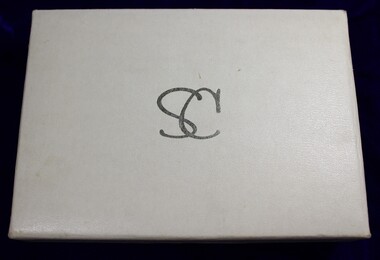
Decorative object - Sarah Coventry jewellery case, C. 1970s - 1980s
Sarah Coventry Pty. Ltd. was a North American jewellery company that was established in 1949 by the Stuart family as part of Emmons Jewelry, Inc. It began operations in England and Australia in 1968, and in Australia it moved from Carlton in Melbourne to Wodonga in 1969. The premises were originally on High St. in Wodonga, but a new warehouse was built in Melbourne Rd. later in 1969. It was a direct selling jewellery business using a party-plan model similar to Tupperware and Avon. The sales reps or 'Hostesses' were provided with jewellery samples in demonstration kits, which they displayed at jewellery parties in their homes. The designs for jewellery such as brooches, necklaces, earrings, chokers and bracelets were purchased from freelance designers and jewellery manufacturers rather than in-house designers. In 1979 Sarah Coventry Pty. Ltd. in Wodonga was bought by three Australian businessmen, including Wodonga local Jim Sawyer, and continued to sell jewellery under the name "Sargem Pty. Ltd”, for several more years in the 1980s.As part of the Sarah Coventry collection, the jewellery box has local significance with the decentralised commercial development of regional centres such as Wodonga in NE Victoria, as well as national and international significance from the perspective of social and economic developments for women after World War II. The direct selling party-plan business model Sarah Coventry was based on is also considered the first of its kind for jewellery.A white and silver jewellery case produced by Sarah Coventry Inc. Writing in silver on top and inside of the lid.On the outside top of the lid "SC" On the inside of the lid "Sarah Coventry Inc ® FINE FASHION JEWELRY"sarah coventry, jewellery, wodonga, costume jewellery, vintage fashion jewellery, brooch, brooches, sawyer -
 City of Kingston
Photograph - Colour, Paul Tresize, 1998
The name Mordialloc was derived from the name Moody Yallock, which comes from the Bunurong language. The Bunurong Peoples are the Traditional Owners of this area. The name means “high water” or “high creek”. In 1839, colonial authorities declared the mouth of the creek, and an additional 830 odd acres as an Aboriginal Reserve, although this proclamation was never gazetted. The reserved land included part of the Carrum Carrum Swamp which was abundant with wild life and natural resources. Regular encroachments, including land sales which began in 1863, were made on the land until 1878 when the Reserve was declared closed, and the land was opened up to land sales. Market gardening and suburban house lots quickly began to develop, and Mordialloc became a renowned picnic and holiday site. Mordialloc Creek is a popular bay side destination for local and visitors, and is a site for boating, kayaking, fishing and swimming, along with many other activities.Colour photograph of Mordialloc Creek, looking out to the bay. Many small fishing and leisure craft are moored on either side of the banks of the creek. To the right hand side can be seen parklands, while the left hand side has a small inlet in which more small crafts are moored.mordialloc, bunurong, traditional owners, suburbs, boats, fishing, waterways -
 City of Kingston
Photograph - Colour, 1998
The name Mordialloc was derived from the name Moody Yallock, which comes from the Bunurong language. The Bunurong Peoples are the Traditional Owners of this area. The name means “high water” or “high creek”. In 1839, colonial authorities declared the mouth of the creek, and an additional 830 odd acres as an Aboriginal Reserve, although this proclamation was never gazetted. The reserved land included part of the Carrum Carrum Swamp which was abundant with wild life and natural resources. Regular encroachments, including land sales which began in 1863, were made on the land until 1878 when the Reserve was declared closed, and the land was opened up to land sales. Market gardening and suburban house lots quickly began to develop, and Mordialloc became a renowned picnic and holiday site. Mordialloc Creek is a popular bay side destination for local and visitors, and is a site for boating, kayaking, fishing and swimming, along with many other activities.Colour photograph of Mordialloc Creek, looking inland.Small fishing and leisure boats are moored on either side of creek, with a view of the Mordialloc Bridge Hotel in the background.mordialloc, bunurong, traditional owners, suburbs, boats, fishing, waterways, hotel -
 City of Kingston
Photograph - Colour, Paul Tresize, 1998
The name Mordialloc was derived from the name Moody Yallock, which comes from the Bunurong language. The Bunurong Peoples are the Traditional Owners of this area. The name means “high water” or “high creek”. In 1839, colonial authorities declared the mouth of the creek, and an additional 830 odd acres as an Aboriginal Reserve, although this proclamation was never gazetted. The reserved land included part of the Carrum Carrum Swamp which was abundant with wild life and natural resources. Regular encroachments, including land sales which began in 1863, were made on the land until 1878 when the Reserve was declared closed, and the land was opened up to land sales. Market gardening and suburban house lots quickly began to develop, and Mordialloc became a renowned picnic and holiday site. Mordialloc Creek is a popular bay side destination for local and visitors, and is a site for boating, kayaking, fishing and swimming, along with many other activities.Colour photograph of Mordialloc Creek, looking inland. Boats are moored on either side of the creek and the Bridge Hotel is visible in the background.mordialloc, bunurong, traditional owners, suburbs, boats, fishing, waterways, hotel -
 City of Kingston
Photograph - Colour, Paul Tresize, 1998
The name Mordialloc was derived from the name Moody Yallock, which comes from the Bunurong language. The Bunurong Peoples are the Traditional Owners of this area. The name means “high water” or “high creek”. In 1839, colonial authorities declared the mouth of the creek, and an additional 830 odd acres as an Aboriginal Reserve, although this proclamation was never gazetted. The reserved land included part of the Carrum Carrum Swamp which was abundant with wild life and natural resources. Regular encroachments, including land sales which began in 1863, were made on the land until 1878 when the Reserve was declared closed, and the land was opened up to land sales. Market gardening and suburban house lots quickly began to develop, and Mordialloc became a renowned picnic and holiday site. Mordialloc Creek is a popular bay side destination for local and visitors, and is a site for boating, kayaking, fishing and swimming, along with many other activities.Colour photograph of Mordialloc Creek with boats moored on both sides of the street and Pompei's boat yard visible on the right hand side of the creek., Main Street and St Brigid's Catholic Church are visible in backgroundmordialloc, bunurong, traditional owners, suburbs, boats, fishing, waterways, hotel, church -
City of Kingston
Photograph - Colour, Paul Tresize, 1998
The name Mordialloc was derived from the name Moody Yallock, which comes from the Bunurong language. The Bunurong Peoples are the Traditional Owners of this area. The name means “high water” or “high creek”. In 1839, colonial authorities declared the mouth of the creek, and an additional 830 odd acres as an Aboriginal Reserve, although this proclamation was never gazetted. The reserved land included part of the Carrum Carrum Swamp which was abundant with wild life and natural resources. Regular encroachments, including land sales which began in 1863, were made on the land until 1878 when the Reserve was declared closed, and the land was opened up to land sales. Market gardening and suburban house lots quickly began to develop, and Mordialloc became a renowned picnic and holiday site. Mordialloc Creek is a popular bay side destination for local and visitors, and is a site for boating, kayaking, fishing and swimming, along with many other activities.Colour photograph of Mordialloc Creek with boats moored on both sides of the street and Pompei's boat yard visible on the right hand side of the creek., Main Street and St Brigid's Catholic Church are visible in background.mordialloc, bunurong, traditional owners, boats, fishing -
 City of Kingston
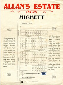
Pamphlet - Black and white, Robert McCamish & John Gilpin (Vendors), For Private Sale Station Entrance Estate, Highett, 1930s
Sales plan for land in the suburb of Highett, bounded by Wickham Road, Railway Parade, Highett Road and Point Nepean Street. The developing urban area of Highett within the City of Kingston. This land sale pamphlet illustrates the subdivision of land within the municipality and the changing demographic of the district as new houses are constructed. The extension of the railway line from the city to Mordialloc opened up the land for development.Black and white pamphlet advertising for private sale the Station Entrance Estate, Highett. Incorporates a map of the estate bordered by Wickham Road, Railway Parade, Highett Road and Point Nepean Road. Handwritten in black ink on reverse: Station Entrance / Estate / Late [indecipherable]highett, land sales, estate -
 City of Kingston
Pamphlet - Colour, Stillwell and Co, The Hill Estate Highett Great Subdivisional Auction Sale, 1917
Sales plan for land in the suburb of Highett, bounded by Point Nepean Road and incorporating Sandford Street, Turner Road, Alfred Street, Peace Street and Tennyson Street. .The developing urban area of Highett within the City of Kingston. This land sale pamphlet illustrates the subdivision of land within the municipality and the changing demographic of the district as new houses are constructed.Colour pamphlet advertising subdivisional auction sale of the Hill Estate Highett. Incorporates a map of the estate bordered by Point Nepean Road and encompassing Sandford Street, Turner Road, Alfred Street, Peace Street and Tennyson St. Handwritten in grey pencil on reverse: Hill Street / Jamieson Handwritten in blue pencil on reverse: The Hill Estate Handwritten in blue pencil on subdivision map: [tick] [on majority of properties marked on map]highett, land sales, estate -
 City of Kingston
Pamphlet - Colour, Allan's Estate Highett, 1930s
Sales plan for land in the suburb of Highett, bounded by Spring Road, Highett Road and Worthing Terrace.The developing urban area of Highett within the City of Kingston. This land sale pamphlet illustrates the subdivision of land within the municipality and the changing demographic of the district as new houses are constructed.Colour pamphlet advertising Allan's Estate, Highett. Incorporates a map of the estate bordered by Spring Road, Highett Road and Worthing Terrace.Handwritten in grey pencil on reverse: Allan's Estate / Highett Crossed out in blue pencil on front: Name and address of what appears to be a solicitorhighett, land sales, estate -
 City of Kingston
Pamphlet - Colour, R. Malcolm Estate Agents et al, Last Chance Land Sale Heritage Estate Cheltenham, c.1994
Sales plan for land in the suburb of Cheltenham, bounded by Chesterville Road and Bernard Street, and incorporating Clendon Court, Tintern Grove and Tintern MewsThis land sale pamphlet illustrates one of the last subdivisions of the century in Cheltenham, incorporating house and land packages. It shows that land sales and subdivision for the area had slowed considerably by the end of the 1900s and that the infrastructure was significantly developed. Colour pamphlet advertising last chance land sale of Heritage Estate Cheltenham. Incorporates a map of the estate bordered by Chesterville Road and Bernard Street, and including Clenton Court, Tintern Grove and Tintern Mews.cheltenham, land sales, estate -
 City of Kingston
Pamphlet - Colour, W. H. Wood Estate Agent, Subdivisional Land Auction Barker's Estate Cheltenham, 1919
Sales plan for land in the suburb of Cheltenham, along Barker StreetThe developing urban area of Cheltenham within the City of Kingston. This land sale pamphlet illustrates the subdivision of land within the municipality and the changing demographic of the district as new houses are constructed.Colour pamphlet advertising subdivisional land auction of Barker's estate, on Barker Street Cheltenham.Handwritten in grey pencil on the subdivision map: a series of numbers on each block possibly indicating the sale price. Handwritten in grey pencil on the subdivision map: Roy- joined to subdivision 6 Handwritten in grey pencil on the subdivision map: x on the border between subdivision 17 and 16, and again on the border between subdivision 12 and 11.cheltenham, land sales, estate -
 City of Kingston
Pamphlet - Black and white, Stott & Burke, Highland Estate Bentleigh, c.1915
... Parkdale Sales plan for land in the suburb of Bentleigh, along ...Sales plan for land in the suburb of Bentleigh, along Collins and Ross Streets, bounded by Jasper Road.The developing urban area of Bentleigh within the City of Kingston. This land sale pamphlet illustrates the subdivision of land within the municipality and the changing demographic of the district as new houses are constructed.Black and white pamphlet advertising for private sale the Highland Estate, Bentleigh. Incorporates a map of the estate between Collins St and Ross St, bordered by Japser Road. Handwritten in grey pencil on map: additional subdivisions numbered 15-19 drawn along Ross St Handwritten in grey pencil on map: indecipherable annotations to subdivisions 1, 3 and 14land sales, bentleigh, estate -
 City of Kingston
Pamphlet - Colour, Ozone Hill Estate, Cheltenham, 1923
... Parkdale Sales plan for land in the suburb of Cheltenham, along ...Sales plan for land in the suburb of Cheltenham, along both sides of Victori Avenue, off Weatherall Road.The developing urban area of Cheltenham within the City of Kingston. This land sale pamphlet illustrates the subdivision of land within the municipality and the changing demographic of the district as new houses are constructed.Colour pamphlet advertising for sale the Ozone Hill Estate, Cheltenham. Incorporates a map of the estate on either side of Victor Avenue, off Weatherall Road. Handwritten in blue ink on the subdivision map: 'Sold' is written on subdivisions 1-4, 8, 11, 13, 16-26, 28, 29, 33, 39-41 Handwritten in blue ink on the subdivision map: 'House being erected' is written on subdivisions 22 and 33. Handwrittten in grey pencil adjacent to subdivisions 21 and 22: Tennis / Courts / being / constructed / here Handwritten in grey pencil at bottom of page: Revised to 30/1/24 Handwritten in grey pencil on subdivision map: assumed land sale price is recorded on subdivisions 5-9, 9-10, 12, 14-15, 27, 30-32, 34-38. land sales, cheltenham, estate -
 City of Kingston
Pamphlet - Colour, H. R. Hill & Co, Walker's Estate, Cheltenham for sale by public auction, c. 1923
... demographic of the district as new houses are constructed. Land sales ...Sales plan for land in the suburb of Cheltenham, encompassing both sides of Walker Grove, a section of Centre Dandenong Rd and Axelton St. The developing urban area of Cheltenham within the City of Kingston. This land sale pamphlet illustrates the subdivision of land within the municipality and the changing demographic of the district as new houses are constructed.Black and white pamphlet advertising for private sale the Station Entrance Estate, Highett. Incorporates a map of the estate bordered by Wickham Road, Railway Parade, Highett Road and Point Nepean Road.Handwritten in black pen on subdivision map: 'x' written on subdivisions 2, 3, 8-11, 15-17, 19. Potentially indicating that these properties did not sell at auction. Handwritten in black pen on subdivision map: assumed sale price on subdivisions 1, 4-7, 12-14, 18, 20-31. land sales, cheltenham, estate -
 City of Kingston
Pamphlet - Colour, Stillwell and Co, Cheltenham Charman Estate Realising Auction, 1921
... Parkdale Sales plan for land in the suburb of Cheltenham, along ...Sales plan for land in the suburb of Cheltenham, along Charman Road and Weatherall Street.The developing urban area of Cheltenham within the City of Kingston. This land sale pamphlet illustrates the subdivision of land within the municipality and the changing demographic of the district as new houses are constructed.Colour pamphlet advertising realising auction of the Charman Estate, Cheltenham. Incorporates a map of the estate, showing subdivisions along Charman Road and Weatherall Street.land sales, cheltenham, estate -
 City of Kingston
Pamphlet - Colour, Duffus Bros, Railway Reserve Highett, c. 1923
Sales plan for land in the suburb of Highett, titled Railway Reserve, incorporating properties along Wolseley Street, Livingston Street, Highett Road and Worthing Road. The developing urban area of Highett within the City of Kingston. This land sale pamphlet illustrates the subdivision of land within the municipality and the changing demographic of the district as new houses and shops are constructed close to infrastructure.Colour pamphlet advertising thirty eight shop and villa sites for sale at the Railway Reserve, Highett. Incorporates a map of the reserve with properties available on Wolseley Street, Livingston Street, Highett Road and Worthing Road. Handwritten in grey pencil: assumed sale price recorded on subdivisions 1-7, 10, 22, 23 and 34 Handwritten in grey pencil on subdivision 4: C. Nevill / City of Melbourne bank Handwritten in grey pencil across subdivision 7: 49' Handwritten in grey pencil across subdivision 21 and 22: 134' Handwritten in grey pencil across subdivision 25 and 26: 200' Handwritten in grey pencil across subdivision 36 and 37 and both top and bottom: 120' Hand drawn in blue pencil: outline of subdivision 4 Hand drawn in blue pencil: outline of subdivisions 7, 23, 28, 37, 38 along left hand side, subdivisions 38, 37 and 36 on Wolseley Street, subdivisions 30 and 29 along Wolseley Street, subdivisions 29 and 24 along the middle of the plan, subdivisions 24 and half of 25 along Livingston Street, half of subdivision 20 along the middle of the plan, subdivisions 21 and 22 along the Right of Way between Livingston Street and Highett Road, and along the right hand border of subdivision 7. Handwritten in ink adjacent to the subdivision plan, updside down, in the bottom right hand corner: 276 / 54 / 280 / 45 / 320 / 202 / 200 / 134 / horizontal line / 11/14 Handwritten in ink adjacent to the subdivision plan, updside down, in the bottom right hand corner: 1714)2200(15 / 1714 / horizontal line / 486land sales, highett -
 City of Kingston
Pamphlet - Colour, Roy Dunn Pty. Ltd, Central Corner Estate Moorabbin and Highett, c. 1923
Sales plan for land in the suburbs of Highett and Moorabbin, bordered by Point Nepean Road and Wickham Road East incorporating William StreetThe developing urban area of Highett and Moorabbin within the City of Kingston. This land sale pamphlet illustrates the subdivision of land within the municipality and the changing demographic of the district as new houses are constructed close to infrastructure.Colour pamphlet advertising for private sale land in the Central Corner Estate in Moorabbin and Highett. Incorporates a map of the estate bordered by Point Nepean Road and Wickham Road East, with subdivisions also available on both sides of William Street. Handwritten in blue pencil on subdivision plan: a tick is drawn on subdivisions 2-18 Handwritten in blue pencil on subdivision 6: a box with an x inside Handwritten in blue pencil on subdivisions 10 and 12: S Handwritten in black ink on front page: [indecipherable] / McKittricks Handwritten in grey pencil on rear page: McKilhick / Nepean Rd Handwritten in grey pencil on rear page upside down: 160000 / 15 8300 [crossed out] land sales, estate, highett, moorabbin -
 City of Kingston
Pamphlet - Colour, Roy Dunn Pty. Ltd, Subdivisional auction of Highett Station Estate, c.1924
Sales plan for land in the suburb of Highett, bounded by Worthing Road, and the Melbourne to Frankston Electric Railway Line, including LePage Street. The developing urban area of Highett within the City of Kingston. This land sale pamphlet illustrates the subdivision of land within the municipality and the changing demographic of the district as new houses are constructed close to infrastructure.Colour pamphlet advertising a subdivisional auction of the Highett Station Estate. Incorporates a map of the estate bordered by Worthing Road and the Melbourne to Frankston Electric Railway, and including LePage Street. Handwritten in black ink on front cover: Late LePage / Wickham Rdland sales, estate, highett -
 City of Kingston
Pamphlet - Colour, W. H. Wood Estate Agent, Realising sub-divisional auction sale Bentleigh Park Estate, Bentleigh, 1920
Sales plan for land in the suburb of Bentleigh, bounded by Centre Road, and incorporating subdivisions on either side of Elizabeth Street (Wheatley Road), Oak Street and Beech Street.The developing urban area of Bentleigh within the City of Kingston. This land sale pamphlet illustrates the subdivision of land within the municipality and the changing demographic of the district as new houses are constructed close to infrastructure.Colour pamphlet advertising a realising sub-divisional auction sale of the Bentleigh Park Estate, Bentleigh. Incorporates a map of the estate bordered by Centre Road, and including Elizabeth Street (Wheatley Road), Oak Street and Beech Street.Hand drawn in grey pencil: a small square on subdivision 33 Hand drawn in grey pencil: a small square incorporating a cross on subdivision 24 Hand written in black ink on reverse: Bentleigh Park / Estate / Ward late Andersonsland sales, estate, bentleigh -
 City of Kingston
Pamphlet - Colour, T. H. Ould Publishing Co, The Ridge Estate, Cheltenham, c. 1930
Sales plan for land in the suburb of Cheltenham, bounded by Johnston Street, Silver Street and Cavanagh Street, incorporating lots on either side of Sunray Avenue.The developing urban area of Cheltenham within the City of Kingston. This land sale pamphlet illustrates the subdivision of land within the municipality and the changing demographic of the district as new houses are constructed close to infrastructure.Colour pamphlet advertising for sale lots in The Ridge Entrance Estate, Cheltenham. Incorporates a map of the estate bordered by Johnston Street, Silver Street and Cavanagh Street, including subdivision lots on either side of Sunray Avenueland sales, estate, cheltenham -
 City of Kingston
Pamphlet - Colour, S. M. Reynolds, Estate Agent, Moorabbin Shire Hall Estate Second Section, c. 1930
Sales plan for land in the suburb of Moorabbin, bounded by South Road and Highbury Street, including Prince Street, Charming Street, Thomas Avenue and Keith Road.The developing urban area of Moorabbin within the City of Kingston. This land sale pamphlet illustrates the subdivision of land within the municipality and the changing demographic of the district as new houses are constructed close to infrastructure.Colour pamphlet advertising for private sale the Moorabbin Shire Hall Estate, Moorabbin. Incorporates a map of the estate bordered by South Road and Highbury Street, including Prince Street, Charming Street, Keith Road and Thomas Avenue.Handwritten in grey pencil on subdivision map below subdivision 63: £4 Handwritten in grey pencil on subdivision map below subdivision 66: 4 Handwritten in grey pencil on subdivision map below subdivision 80: 3. Handwritten in grey pencil on subdivision map below subdivision 81: 4 Handwritten in grey pencil on subdivision map below subdivision 83: 2 Handwritten in grey pencil on subdivision map below subdivision 96: £3 Handwritten in grey pencil on subdivision map below subdivision 97: 3 Handwritten in grey pencil on subdivision map to the left of subdivision 102: 3 Handwritten in grey pencil on subdivision map on the corner of Thomas Avenue and Highbury Street: vertical line next to a square with a cross in it.land sales, estate, moorabbin -
 City of Kingston
Pamphlet - Colour, Fergusson & Mitchell Lith, Sandringham Rises, c. 1888
Sales plan for land in the suburb of Sandringham, bounded by Bluff Road, Bay Road and William Street, and incorporating Frances Street.The developing urban area of Highett (then called Sandringham) within the City of Kingston. This land sale pamphlet illustrates the subdivision of land within the municipality and the changing demographic of the district as new houses are constructed close to infrastructure.Colour pamphlet advertising for sale 35 lots in Sandringham Rises, Sandringham. Incorporates a map of the estate bordered by Bluff Road, Bay Road and William Street, including Frances Street.Handwritten in grey pencil next to the words 'THREE O'CLOCK': 1888 Handwritten in blue ben next to the words '& BUSINESS SITES': 1888land sales, sandringham, highett -
 City of Kingston
Pamphlet - Colour, Brock Bros, South Brighton Township Estate, 1888
Sales plan for land in the suburb of South Brighton (Moorabbin), bounded by Point Nepean Road, South Road, Patterson Street and the Mordialloc Railway Line. Incorporates Wolsely Street and Gordon StreetThe developing urban area of Moorabbin within the City of Kingston. This land sale pamphlet illustrates the subdivision of land within the municipality and the changing demographic of the district as new houses are constructed close to infrastructure.Colour pamphlet advertising for private sale the South Brighton Township Estate, South Brighton. Incorporates a map of the estate bordered by Point Nepean Road, South Road, Patterson Street, and the Mordialloc Railway Line. Includes Wolsley Street and Gordon Street. land sales, south brighton, estate, moorabbin -
 City of Kingston
Pamphlet - Colour, Stillwell and Co, The Hill Estate, Highett, 1917
Sales plan for land in the suburb of Highett, bounded by Point Nepean Road and including Sandford Street, Turner Road, Alfred Street and Peace Street.The developing urban area of Highett within the City of Kingston. This land sale pamphlet illustrates the subdivision of land within the municipality and the changing demographic of the district as new houses are constructed close to infrastructure.Colour pamphlet advertising for sale at auction The Hill Estate, Highett. Incorporates a map of the estate bordered by Point Nepean Road and including Sandford Street, Turner Road, Alfred Street and Peace Street.Handwritten in grey pencil on subdivision map next to subdivisions 91, 92, 93, 106, 107 and 108: x Handwritten in grey pencil on back cover: The / Hill Estate / Highettland sales, estate, highett -
 City of Kingston
Pamphlet - Colour, Farrow Falcon Press, Printers, Ozone Estate, Bluff Road, Hampton, c.1940
Sales plan for land in the suburb of Hampton (Highett), bounded by Bluff Road, Wickham Road, Peterson Street and June Street. Includes Morley Street, Follett Avenue, and Parrett StreetThe developing urban area of Highett within the City of Kingston. This land sale pamphlet illustrates the subdivision of land within the municipality and the changing demographic of the district as new houses are constructed close to infrastructure.Colour pamphlet advertising for private sale the Ozone Estate, Bluff Road Hampton. Incorporates a map of the estate bordered by Bluff Road, Wickham Road, June Street and Peterson Street including Morley Street, Follett Avenue and Parrett Street.Handwritten in grey pencil on reverse: Ozone Printed in purple ink on front top right-hand corner: Vendors are - Leslie Harcourt MacGowan, Esq / Neerim Road, Caulfield / & / Arthur Alfred Parrett, Esq / 311 Flinders Lane / Melbourneland sales, estate, hampton, highett -
 City of Kingston
Pamphlet - Colour, Farrow Falcon Press, Printers, Ozone Estate, Bluff Road, Hampton, c. 1940
Sales plan for land in the suburb of Hampton (Highett), bounded by Bluff Road, Wickham Road, Peterson Street and June Street. Includes Morley Street, Follett Avenue, and Parrett StreetThe developing urban area of Highett within the City of Kingston. This land sale pamphlet illustrates the subdivision of land within the municipality and the changing demographic of the district as new houses are constructed close to infrastructure.Colour pamphlet advertising for private sale the Ozone Estate, Bluff Road Hampton. Incorporates a map of the estate bordered by Bluff Road, Wickham Road, June Street and Peterson Street including Morley Street, Follett Avenue and Parrett Street.Handwritten in grey pencil on rear: Ozone Estateland sales, estate, highett, hampton -
 City of Kingston
Pamphlet - Black and white, J. F. Brady, The Hill Estate, Highett, c. 1905
Sales plan for land in the suburb of Highett, bounded by Sandford Street, Turner Street and Point Nepean RoadThe developing urban area of Highett within the City of Kingston. This land sale pamphlet illustrates the subdivision of land within the municipality and the changing demographic of the district as new houses are constructed close to infrastructure.Black and white pamphlet advertising for sale the Hill Estate, Highett. Incorporates a map of the estate bordered by Sandford Street, Turner Street and Point Nepean Road.Handwritten in grey pencil on reverse: The Hillland sales, highett, estate -
 City of Kingston
Pamphlet - Colour, Highett Town, 1888
Sales plan for land in the suburb of Highett, bounded by Highett Road, Worthing Terrace and the railway line, and incorporating Major Street and Train Street.The developing urban area of Highett within the City of Kingston. This land sale pamphlet illustrates the subdivision of land within the municipality and the changing demographic of the district as new houses are constructed close to infrastructure.Colour pamphlet advertising for private sale the Station Entrance Estate, Highett. Incorporates a map of the estate bordered by Wickham Road, Railway Parade, Highett Road and Point Nepean Road.land sales, highett