Showing 614 items
matching house sales
-
 City of Kingston
Pamphlet - Colour, J. F. Brady, Matthiesson's Estate, Highett, c. 1905
Sales plan for land in the suburb of Highett, bounded by Tennyson Street, James Street and Point Nepean Road and including Maher Street, Connors Street, Enright Street, Edward Street, James Street and Matthieson Street.The developing urban area of Highett within the City of Kingston. This land sale pamphlet illustrates the subdivision of land within the municipality and the changing demographic of the district as new houses are constructed close to infrastructure.Colour pamphlet advertising for private sale subdivisions in the Matthiesson's Estate, Highett. Incorporates a map of the estate bordered by Tennyson Street, James Street and Point Nepean Road and including Maher Street, Connors Street, Enright Street, Edward Street, James Street and Matthieson Street.Handwritten in blue pencil: x marked on every subdivision on the map Handwritten in grey pencil at the end of the Price List: x not sold Handwritten in grey pencil adjacent to subdivisions 58, 167 and 166: JP. Turner Handwritten in grey pencil adjacent to subdivision 164: [indecipherable] Markings in grey pencil around the edges of the subdivision map Handwritten in grey pencil on reverse: Matthiesson / Matthiesson Estate / Matthiesson Estateland sales, estate, highett -
 City of Kingston
Pamphlet - Colour, Smith, Nicolson Pty. Ltd, Cheltenham Estate, c. 1890
Sales plan for land in the suburb of Cheltenham, bounded by Point Nepean Road and Swinden Avenue, including Evesham Road and Wallingford Street.The developing urban area of Cheltenham within the City of Kingston. This land sale pamphlet illustrates the subdivision of land within the municipality and the changing demographic of the district as new houses are constructed close to infrastructure.Colour pamphlet advertising for private sale Cheltenham Estate. Incorporates a map of the estate bordered by Point Nepean Road and Swinden Avenue, including Evesham Road, and Wallingford Street.Handwritten in red ink on subdivison 45: D / H Handwritten in red ink on subdivision 46: Anderson Handwritten in red ink on subdivisions 88, 87, 77 and 56: K / D Handwritten in red ink on subdivision 86: D / H Handwritten in red ink on subdivision 63 and 62: Hudson Handwritten in red ink on subdivision 59 [indecipherable] Handwritten in red ink on subdivision 58: aB Handwritten in red ink on subdivision 57: Lavosh Handwritten in grey pencil on subdivision 28, 26, 24, 67, 58, 49: B Handwritten in grey pencil on subdivisions 78 and 79: Paint Handwritten in purple pencil on subdivsion 114 and 86: B land sales, estate, cheltenham -
 City of Kingston
Pamphlet - Colour, Moorabbin News Print, Auction = Sale Heather Grove Estate, c. 1914
Sales plan for land in the suburb of Cheltenham, bounded by Tulip Grove and Heather Grove.The developing urban area of Highett within the City of Kingston. This land sale pamphlet illustrates the subdivision of land within the municipality and the changing demographic of the district as new houses are constructed close to infrastructure.Colour pamphlet advertising auction of Heather Grove Estate, Cheltenham. Incorporates a map of the estate bordered by Wickham Road, Railway Parade, Highett Road and Point Nepean Road.Handwritten in grey pencil on subdivision 1: Sold / 20/- Handwritten in grey pencil on subdivision 2: 25/- Handwritten in grey pencil on subdivision 3: 30/- Handwritten in grey pencil on subdivision 4: 110 / 30/- Handwritten in grey pencil on subdivisions 1, 11, 10, 9 and 8: Sold Handwritten in grey pencil beneath 'Heather Grove': 20/- 20/- 20/- 20/- Handwritten in black ink on subdivison 12 and 7: £85 Handwritten in back ink on subdivision 5: £60 Handwritten in back ink on subdivision 6: £65 Handwritten in grey pencil above subdivision map: 1-8-9-10-11 Handwritten in grey pencil above subdivision map: [enclosed in a circle] 12- / £75 Handwritten in grey pencil above subdivision map: [enclosed in a circle] 2 / £85 Handwritten in grey pencil above subdivision map: [enclosed in a circle] 3 / £100 Handwritten in grey pencil above subdivision map: [enclosed in a circle] 4 / £100 Handwritten in grey pencil above subdivision map: [enclosed in a circle] 5 / £60 Handwritten in grey pencil above subdivision map: [enclosed in a circle] 6 / £65 Handwritten in grey pencil above subdivision map: [enclosed in a circle] 7 / £25- Handwritten in grey pencil above subdivision map: [enclosed in a circle] £125 / [indecipherable] Handwritten in grey pencil above subdivision map: 37.00 / 18.10 / 56.80 / 3 / [horizontal line] / 59 8 Handwritten in grey pencil along railway line marking: 21/6 / 12/6 / 13/- / 19/-land sales, estate, cheltenham -
 Melbourne Legacy
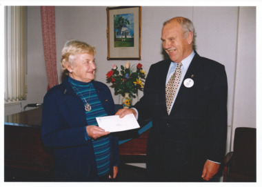
Photograph, Legatee David Ford, 2003
This photo of President David Ford and a widow with an envelope was taken on the same film as celebrations for the 80th Anniversary of Legacy in the grounds of Government House in 2003. It could be the widow passing over funds raised by the widows clubs to President Ford.There was a strong relationship between Legatees and the widows clubs. Widows clubs would raise funds through several ventures including their stalls and stamp sales throughout the year.Colour photo of President David Ford and a widow.Printed on the back -
 Melbourne Legacy
Document - Document, minutes, Biography of Sir Stanley Savige, 1960
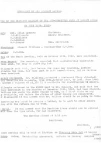
Minutes from the 11th meeting of the committee held at Legacy House on 15 July 1960 reveals that 2000 copies of the book had been sold but sales were slowing. Because minutes of the 9th and 10th committee meetings are missing, information on the project is incomplete, but these minutes refer to the fact that the author wanted his loan of $1000 to be refunded, reversing his advice in the minutes of the 15 December 1958. The copy of the financial statement noted as attached to the minutes is missing.An indication of possible sales results of the sale of the biography of Sir Stanley Savige.One quarto size sheet of copy paper, carbon copy of minutes of a meeting about the biography.savige book, biography -
 Melbourne Tram Museum
Photograph - Black & White Photograph/s, Tramway Museum Society of Victoria (TMSV), c1975
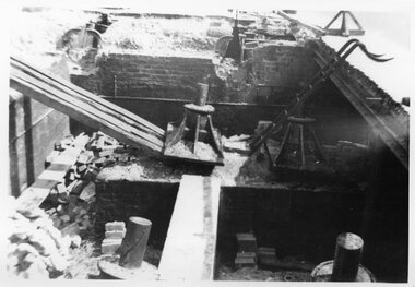
Black & White Photograph by the TMSV Sales of the demolition of winding sheave pit - location not known. Shows the size of the cable pins.Has the TMSV Sales stamp on rear.trams, tramways, cable trams, cable grip, cables, winding houses, tram 565 -
 Melbourne Tram Museum
Photograph - Black & White Photograph/s, Tramway Museum Society of Victoria (TMSV), c1975
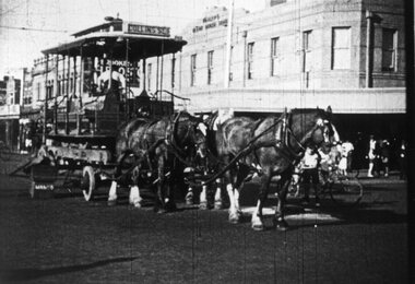
Black & White Photograph by the TMSV Sales of a former grip car being transport on a jinker, pulled by three horses. Photo - Victoria Ave at the corner of Beaconsfield Pde - with the Bleak House Hotel in the background. Advised by Mal Rowe. From an email from Robert Green, 19-08-2021 - advised "The Herald of 10 May 1935, p.4 has the following little paragraph : Cable Tram Tableau Entitled “Transport Cavalcade”: Horse-laughs - real ones – were heard today when a team of horses, drawing a lorry upon which was a dis-used cable tram dummy sporting “Collins Street” upon the front and “South Melb Beach” at the rear, passed along Swanston Street. Neddy’s superiority complex at seeing out these early manifestations of our mechanical age was heightened when the front wheel of a nearby motor-truck fell off." Image has been reproduced from a movie - Commuting by Cable?Has the TMSV Sales stamp on rear.trams, tramways, cable trams, grip tram, beaconsfield parade, albert park -
 Melbourne Tram Museum
Photograph - Set of 5 Black & White Photograph/s, Cable tram operations, c1975
... held. .3 - a worker watching the cable entering a winding house ...1 - employee with a uniform cap - could be a shunter - lifting the cable into the adjacent grip car. Marked on rear as "Lonsdale St" .2 - worker in a cable pulley maintenance pit oiling the mechanism - note the other pits. Has put a "Danger" sing out on the roadway. Marked on rear "Bourke and Spring St 1938" Two copies held. .3 - a worker watching the cable entering a winding house looking for damage - what a boring job! Marked on rear as "Checking cables 1938" .4 - communications pillar - or box - to communicate with the winding house .5 - photos shows the grip in the roadway Images have been reproduced from a movie - Commuting by Cable?Yields information of the cable tram operations c1938.Series of five Black & White Photographs by the TMSV Sales. Has the TMSV Sales stamp on rear with some notes in pencil on the rear as shown above.trams, tramways, cable trams, grip tram, cables, winding house -
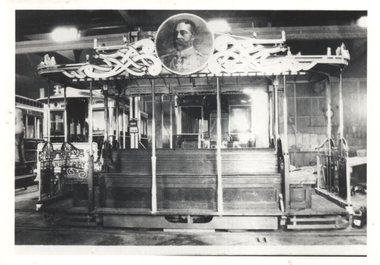 Melbourne Tram Museum
Photograph - Decorated cable grip or dummy - King George V, 1919
Photo of the dummy or grip car decorated for the Celebration of Peace July 1919. Decorated dummy and car which, electrically illuminated, traversed the Melbourne cable tramways in celebration of peace, on the evenings of Monday and Tuesday, the 14th and 15th July, 1919. Photographed in a car house or depot. Refer to items 4255 and 4256 for further details.Yields information the grip car decorated for the Celebration of Peace.Black and White photograph on plain paper. Second copy has a wider view and plain back.First view has TMSV Sales stamp and note on rear.world war 1, cable trams, celebrations, peace tram, tramway board, grip car -
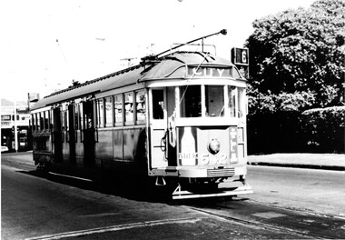 Melbourne Tram Museum
Photograph - Black & White Photograph/s, tram W2 542 at the Glen Iris terminus, 1960's
Black and white photograph of tram W2 542 at the Glen Iris terminus, with the destination of City route 6. Has the large hedge of a house and shops in the background. Trams has good appearance, possibly just after a repaint. Has a number of adverts on the front - including one for Milk. Tram at the intersection of Malvern and Darling Roads, Glen Iris. Printed on Fujichrome paper. Not known who took the photograph or when it was printed.Stamped in black ink on back "TMSV Sales"trams, tramways, glen iris, darling rd, route 6, tram 542 -
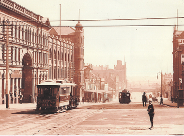 Melbourne Tram Museum
Photograph - Bourke St from William St looking west - cable trams, c1910
Photograph shows the view from William St looking west along Bourke St. Has two cable tram sets in the view, along with on the south side of Bourke Street the former St. James Building, Gollin & Company Building, then over King Street, Bourke Street West Police Station, McLean Bros. & Rigg Ironmongery & Hardware Store, (later Hudon's Store) and the Tramways Head Office Building. On the northside of Bourke Street is the Massey-Harris Building, John Connell & Co. Pty Ltd "Gresham House" and over King Street, H.V. McKay Harvester's Sunshine Head Office. Also in the distance is the Spencer Street Railway Station buildings. The Archway visible through the St. James Building led into the former Lt. James Street. Yields information about Bourke Street between 1909 and 1913Photograph - sepia toned on A4 sheetHas TMSV Sales stamp on rear.trams, bourke st, william st, cable trams, tramways, tram 402, st. james building -
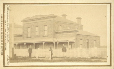 Bacchus Marsh & District Historical Society
Photograph, Court House Main Street Bacchus Marsh 1883
The Court House in Main Street Bacchus Marsh was built in 1858 using local sandstone. It opened in 1859. It has been used for jury trials, a Court of Petty Sessions, a County Court and a Crown Land sales office. Other uses included an office for the Registrar of Births and Deaths, a Diary Inspectors office from 1863-1865, and as meeting rooms for the Bacchus Marsh Roads Board, a forerunner of the Shire Council. It was also used by the Bacchus Marsh Shire Council for its offices until at least 1884. In more recent years it has functioned as a Magistrates Court with weekly court sessions. Small sepia unframed photograph on card with gold border framing photograph. Housed in the album, 'Photographs of Bacchus Marsh and District in 1883 by Stevenson and McNicoll'. The view of the Court House building is seen from the northern side of Main Street looking south or south-east. Three men are standing in of the street in front of the building. The men on the left and the right appear to be police officers. The man in the middle is in civilian clothes and might be an officer or employee of the Court House. A white picket fence is in front of the building. This is no longer present.On the front: Stevenson & McNicoll. Photo. 108 Elizabeth St. Melbourne. COPIES CAN BE OBTAINED AT ANY TIME. On the back: LIGHT & TRUTH inscribed on a banner surmounted by a representation of the rising sun. Copies of this Portrait can be had at any time by sending the Name and Post Office Money Order or Stamps for the amount of order to STEVENSON & McNICOLL LATE BENSON & STEVENSON, Photographers. 108 Elizabeth Street, MELBOURNE. stevenson and mcnicoll 1883 photographs of bacchus marsh and district, courthouses, bacchus marsh court house -
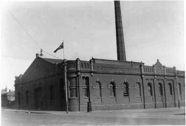 Melbourne Tram Museum
Photograph - Engine House - Abbotsford and Queensberry Sts, Tramway Museum Society of Victoria (TMSV), 1934
Photograph of of the North Melbourne engine house, or power house or winding house on the corner of Abbotsford St and Queensberry St. Dated 1934 on the rear of the photo. Shows the chimney. This building remains intact other than for the chimney.Yields information about cable trams engine houses.Black & White Photograph - two copies held.Has the TMSV Sales stamp on the rear and a date "Nth Melb Engine House 1934" in pencil on the rear.trams, tramways, cable trams, abbotsford st, engine houses, power house, winding houses, queensberry st -
 City of Kingston
Pamphlet - Colour, Arthur Tuckett & Son, Auctioneers and Subdivisional Specialists, Auction of Station Estate, Moorabbin, 1923
Sales plan for land in the suburb of Moorabbin, bounded by Railway Crescent, South Road, Jasper Road and Pattersons Road.The developing urban area of Moorabbin within the City of Kingston. This land sale pamphlet illustrates the subdivision of land within the municipality and the changing demographic of the district as new houses are constructed.Colour pamphlet advertising an auction of the Station Estate Moorabbin. Incorporates details of the shopping facilities, proximity to the railway line, variety of schools and churches in the area, and a sales plan for home sites and shop fronts. Incorporates a map of the estate bordered by Pattersons Road, Japer Road, South Road and Railway Crescent. Handwritten in grey pencil top right front page: Station Estate / late [indecipherable] Handwritten in red pencil on subdivision map: x [on majority of properties marked on the map] Handwritten in grey pencil on subdivision map: additional subdivisions drawn in and large lines drawn across the mapmoorabbin, land sales, estate