Showing 17376 items
matching view-master
-
 Ringwood and District Historical Society
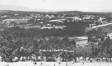
Photograph, Birds eye view of Ringwood 1912
Written onto photograph, "Birds eye view of Ringwood". Small photograph notes that photograph was taken in 1912 and that is shows the brickworks and Reimers house in Warrandyte Rd. -
 Eltham District Historical Society Inc
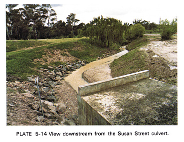
Work on paper (Sub-Item) - Photograph, View downstream from the Susan Street culvert
Colour photograph of the view downstream from the Susan Street culvert, Elthameltham, susan street, culvert, drain, channel -
 Eltham District Historical Society Inc
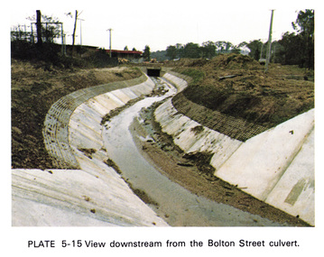
Work on paper (Sub-Item) - Photograph, View downstream from the Bolton Street culvert
Colour photograph of the view downstream from the Bolton Street culvert, Elthameltham, channel, concrete, drain, bolton street -
![Photograph - Digital Image, Greensborough Cemetery [view 3] 2013, 18/06/2013](/media/collectors/4f729f5697f83e03086015b8/items/54c5f91f2162f1173055ddc2/item-media/54c5f9512162f1173055dfc8/item-fit-380x285.jpg) Greensborough Historical Society
Greensborough Historical SocietyPhotograph - Digital Image, Greensborough Cemetery [view 3] 2013, 18/06/2013
View of Greensborough Cemetery, June 18th 2013. Photography by Marilyn Smith.Greensborough Cemetery was created when land was given for the cemetery by Mr William Poulter, a local settler, about 1864. The cemetery holds the graves of many early settlers in the district. Digital copy of colour photograph of Greensborough Cemeterygreensborough cemetery -
![Photograph - Digital Image, Greensborough Cemetery [view 2] 2014, 28/05/2014](/media/collectors/4f729f5697f83e03086015b8/items/54c5f9d52162f1173055e7b3/item-media/54c5fa9f2162f1173055f50b/item-fit-380x285.jpg) Greensborough Historical Society
Greensborough Historical SocietyPhotograph - Digital Image, Greensborough Cemetery [view 2] 2014, 28/05/2014
View of Greensborough Cemetery, 28th May 2014. Photography by Marilyn Smith.Greensborough Cemetery was created when land was given for the cemetery by Mr William Poulter, a local settler, about 1864. The cemetery holds the graves of many early settlers in the district. Digital copy of colour photograph of Greensborough Cemeterygreensborough cemetery -
![Photograph - Digital Image, Greensborough Cemetery [view 3] 2014, 28/05/2014](/media/collectors/4f729f5697f83e03086015b8/items/54c5fab02162f1173055f6ef/item-media/54c5fadf2162f1173055faf6/item-fit-380x285.jpg) Greensborough Historical Society
Greensborough Historical SocietyPhotograph - Digital Image, Greensborough Cemetery [view 3] 2014, 28/05/2014
View of Greensborough Cemetery, 28th May 2014. Photography by Marilyn Smith.Greensborough Cemetery was created when land was given for the cemetery by Mr William Poulter, a local settler, about 1864. The cemetery holds the graves of many early settlers in the district. Digital copy of colour photograph of Greensborough Cemeterygreensborough cemetery -
![Photograph - Digital Image, Greensborough Cemetery [view 4] 2014, 28/05/2014](/media/collectors/4f729f5697f83e03086015b8/items/54c5fb402162f1173055ff6a/item-media/54c5fb702162f117305602cc/item-fit-380x285.jpg) Greensborough Historical Society
Greensborough Historical SocietyPhotograph - Digital Image, Greensborough Cemetery [view 4] 2014, 28/05/2014
View of Greensborough Cemetery, 28th May 2014. Photography by Marilyn Smith.Greensborough Cemetery was created when land was given for the cemetery by Mr William Poulter, a local settler, about 1864. The cemetery holds the graves of many early settlers in the district. Digital copy of colour photograph of grave/headstone.greensborough cemetery -
![Photograph - Digital Image, Greensborough Cemetery [view 5] 2014, 28/05/2014](/media/collectors/4f729f5697f83e03086015b8/items/54c5fbcf2162f11730560d50/item-media/54c5fc022162f11730560fbb/item-fit-380x285.jpg) Greensborough Historical Society
Greensborough Historical SocietyPhotograph - Digital Image, Greensborough Cemetery [view 5] 2014, 28/05/2014
View of Greensborough Cemetery, 28th May 2014. Photography by Marilyn Smith.Greensborough Cemetery was created when land was given for the cemetery by Mr William Poulter, a local settler, about 1864. The cemetery holds the graves of many early settlers in the district. Digital copy of colour photograph of Greensborough Cemeterygreensborough cemetery -
![Photograph - Digital image, Greensborough Cemetery [view 1], 18/06/2013](/media/collectors/4f729f5697f83e03086015b8/items/54c5f72c2162f1173055bbb2/item-media/54c5f7722162f1173055c101/item-fit-380x285.jpg) Greensborough Historical Society
Greensborough Historical SocietyPhotograph - Digital image, Greensborough Cemetery [view 1], 18/06/2013
View of Greensborough Cemetery, June 18th 2013. Photography by Marilyn Smith.Greensborough Cemetery was created when land was given for the cemetery by Mr William Poulter, a local settler, about 1864. The cemetery holds the graves of many early settlers in the district. Digital copy of colour photograph of Greensborough Cemeterygreensborough cemetery -
![Photograph - Digital Image, Greensborough Cemetery [view 2] 2013, 18/06/2013](/media/collectors/4f729f5697f83e03086015b8/items/54c5f8802162f1173055d3d6/item-media/54c5f8ba2162f1173055d66a/item-fit-380x285.jpg) Greensborough Historical Society
Greensborough Historical SocietyPhotograph - Digital Image, Greensborough Cemetery [view 2] 2013, 18/06/2013
View of Greensborough Cemetery, June 18th 2013. Photography by Marilyn Smith.Greensborough Cemetery was created when land was given for the cemetery by Mr William Poulter, a local settler, about 1864. The cemetery holds the graves of many early settlers in the district. Digital copy of colour photograph of Greensborough Cemeterygreensborough cemetery -
![Photograph - Digital Image, Greensborough Cemetery [view 1] 2014, 28/05/2014](/media/collectors/4f729f5697f83e03086015b8/items/581060aed0cdd12660a1c09d/item-media/581060f6d0cdd12660a1ece7/item-fit-380x285.jpg) Greensborough Historical Society
Greensborough Historical SocietyPhotograph - Digital Image, Greensborough Cemetery [view 1] 2014, 28/05/2014
View of Greensborough Cemetery, 28th May 2014. Photography by Marilyn Smith.Greensborough Cemetery was created when land was given for the cemetery by Mr William Poulter, a local settler, about 1864. The cemetery holds the graves of many early settlers in the district. Digital copy of colour photograph of Greensborough Cemetery -
 Greensborough Historical Society
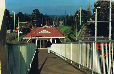
Photograph - Digital image, Frank Solomon, Greensborough Station: view down ramp, 1990c
Greensborough Station: view down ramp from pedestrian overpass to station.Digital copy of colour photographgreensborough station -
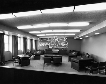 Eltham District Historical Society Inc
Photograph, Hugh Fisher, Eltham - View of Council Chamber, c.1965, 1965
View of Council Chamber in brand new Eltham Shire Offices 1965This photo forms part of a collection of photographs gathered by the Shire of Eltham for their centenary project book, "Pioneers and Painters: 100 years of the Shire of Eltham" by Alan Marshall (1971). The collection of over 500 images is held in partnership between Eltham District Historical Society and Yarra Plenty Regional Library (Eltham Library) and is now formally known as 'The Shire of Eltham Pioneers Photograph Collection.' It is significant in being the first community sourced collection representing the places and people of the Shire's first one hundred years.Digital imagesepp, shire of eltham pioneers photograph collection, eltham, eltham shire office, council chamber -
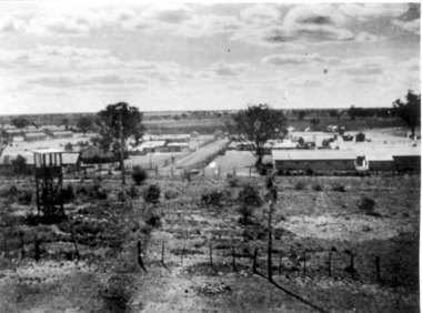 Tatura Irrigation & Wartime Camps Museum
Photograph, View of Camp 3
View of Camp 3 taken from Southern tower, c.1946. -
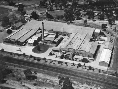 Stawell Historical Society Inc
Photograph, North Western Woollen Mills with the Rail line in foreground -- Aerial View
North Western Woollen Mills Aerial View. Rail line in foregroundstawell industry -
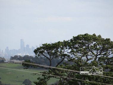 Eltham District Historical Society Inc
Photograph, Liz Pidgeon, View of Melbourne from the Moor-rul viewing platform at the War Memorial Park at Kangaroo Ground, 10 August 2016
View of Melbourne from the Moor-rul viewing platform at the War Memorial Park at Kangaroo Ground. As part of a program to acknowledge the Anzac Centenary Nillumbik Shire Council partnered with Yarra Plenty Regional Library to provide a bus tour with commentary of local sites of significance. These included Eltham township, the Shire of Eltham War Memorial at Kangaroo Ground, Christmas Hills war memorial, Hurstbridge memorial recreation park and finshed at Eltham Library to view the Writing the War exhibtion at Eltham Library Community Gallery. Born Digitalwar memorials, shire of nillumbik, kangaroo ground, moor-rul viewing platform, melbourne, skyline, view -
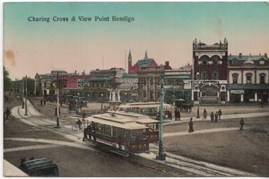 Ballarat Tramway Museum
Postcard, "Charing Cross & View Point Bendigo", 1903
The photo shows three Bendigo California Combination single truck cars at Charing Cross, looking southwest with the Alexandria Fountain in the centre. Trams 5 and 14 are in the view along with another behind them. The Bendigo electric tram system commenced operations in 1903 and given the appearance of the roadways and tram tracks, the photo was taken soon after opening. In the view are the View Point Hotel, signs for Moran Cato, Coperative Distribution, W J Jackson Tailor, The Age and several horse-drawn cabs. Card was printed in Germany.Yields information about Charing Cross and Bendigo's trams in 1903.Postcard - colour divided back, used as a letter.Card to a Mother from her son Alex.tramways, trams, bendigo, charing cross, alexandra fountain, view point, tram 5 -
 Glenelg Shire Council Cultural Collection
Photograph, View of Portland Harbour and port, 1960s
Port of Portland Authority archives.Front: (no inscriptions) Back: (no inscriptions)port of portland, lady bay -
 Eltham District Historical Society Inc
Photograph, View from Porter Street, Eltham to south east, c.1994, 1994c
Colour photograph of view southeast from Porter Street, Eltham c.1994 showing new housing development on Riverview Estate formerly Fabbro farm.porter street, eltham, riverview estate, m fabbro -
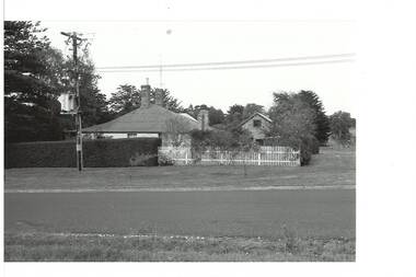
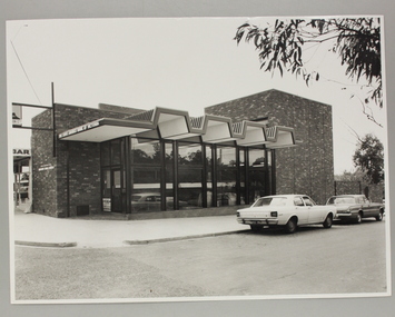 Ringwood and District Historical Society
Photograph, Exterior view of Ringwood North State Bank , north-east corner of Dickson's Cresent and Warrandyte Road
The new Ringwood North State Bank premises on the north-east corner of Dickson's Cresent. Exterior view. Unknown date. Opened 25 October 1971At the corner of Dickson's Cresent and Warrandyte Road, Ringwood North. Photographer Laurie Richards, 4 Tower Avenue, Alphington. Negative #71-3031 -
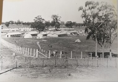 Tatura Irrigation & Wartime Camps Museum
Photograph, Camp 13 View, 1940
Photograph donated to Museum by Fred Ruddy who was one of the guards at Camp 13.Black and white photograph. General view from corner perimeter of Camp 13. Huts and tents particularly. It would seem tents the sleeping quarters of the guards.camp 13, fred ruddy, camp 13 sleeping quarters -
 Buninyong & District Historical Society
Photograph - B/W photograph, Eyre Cottage, former home of Robert Allen, c 1855, on S/W cnr. of Eyre and Winter Streets, side view from N/W, 1994
Original Building dates from around 1855, strong connection with Robert Allen, prominent citizen in early goldrush, links through him to Allen Store and Old Library.Built by prominent citizen and benefactor, early gold-rush dwellingEyre Cottage, former home of Robert Allen, c 1855, on S/W cnr. of Eyre and Winter Streets, side view from N/W.buninyong, eyre st, winter st, robert allen, streetscape, building -
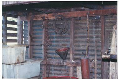 Buninyong & District Historical Society
Photograph - Original Photograph, Geoff Little, Whykes Slaughterhouse, Durham Lead, interior of boiler house, corner view, 1995
IndustryWhykes Slaughterhouse, Slaughterhouse Lane, Durham Lead, Whykes Slaughterhouse, Durham Lead, interior of boiler house, corner view. Colour and b/w copiesbuninyong, whykes, slaughterhouse, durham lead, butchers, boiler house -
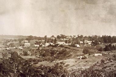 Greensborough Historical Society
Photograph - Digital image, View over Greensborough from Sondemeyer's Hill, 1925c
Early 20th century view of Greensborough showing the rural nature of the area at this time.Digital copy of sepia photograph.greensborough -
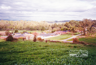
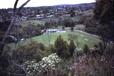 Greensborough Historical Society
Photograph - Digital Image, Greensborough View over Partington's Flat, 1983c
View of Greensborough and Club House in Partington's Flat in1983 [Faye Partington's Date] .Digital copy of colour photograph.greensborough -
![Photograph - Digital image, Greensborough Cemetery [view 5], 08/03/2012](/media/collectors/4f729f5697f83e03086015b8/items/54c4afd22162f1070475eca3/item-media/54c4b0222162f1070475f0d9/item-fit-380x285.jpg) Greensborough Historical Society
Greensborough Historical SocietyPhotograph - Digital image, Greensborough Cemetery [view 5], 08/03/2012
View of Greensborough Cemetery on 8/3/2012. Photograph taken by Jasmin Burge.Greensborough Cemetery was created when land was given for the cemetery by Mr William Poulter, a local settler, about 1864. The cemetery holds the graves of many of the early settlers in the district. The cemetery holds approximately 250 grave sites with 350 people buried there. Digital copy of colour photograph of cemetery.greensborough cemetery -
![Photograph - Digital image, Greensborough Cemetery [view 6], 26/07/2011](/media/collectors/4f729f5697f83e03086015b8/items/54c4b0aa2162f1070475f8a9/item-media/54c4b0df2162f1070475fb80/item-fit-380x285.jpg) Greensborough Historical Society
Greensborough Historical SocietyPhotograph - Digital image, Greensborough Cemetery [view 6], 26/07/2011
View of Greensborough Cemetery 26/07/2011. Photograph taken by Jasmin Burge.Greensborough Cemetery was created when land was given for the cemetery by Mr William Poulter, a local settler, about 1864. The cemetery holds the graves of many of the early settlers in the district. The cemetery holds approximately 250 grave sites with 350 people buried there. This photo captures the grave of Giles Poulter.Digital copy of colour photograph of cemetery.greensborough cemetery -
![Photograph - Digital image, Greensborough Cemetery [view 7], 04/10/2011](/media/collectors/4f729f5697f83e03086015b8/items/54c4b1412162f107047606db/item-media/54c4b1702162f10704760d3a/item-fit-380x285.jpg) Greensborough Historical Society
Greensborough Historical SocietyPhotograph - Digital image, Greensborough Cemetery [view 7], 04/10/2011
View of Greensborough Cemetery 04/10/2011. Photograph taken by Jasmin Burge.Greensborough Cemetery was created when land was given for the cemetery by Mr William Poulter, a local settler, about 1864. The cemetery holds the graves of many of the early settlers in the district. The cemetery holds approximately 250 grave sites with 350 people buried there. Digital copy of colour photograph of cemetery.greensborough cemetery -
![Photograph - Digital image, Greensborough Cemetery [view 2], 08/03/2012](/media/collectors/4f729f5697f83e03086015b8/items/54c4b1cd2162f10704761367/item-media/54c4b1fd2162f1070476170e/item-fit-380x285.jpg) Greensborough Historical Society
Greensborough Historical SocietyPhotograph - Digital image, Greensborough Cemetery [view 2], 08/03/2012
View of Greensborough Cemetery 08/03/2012. Photograph taken by Jasmin Burge.Greensborough Cemetery was created when land was given for the cemetery by Mr William Poulter, a local settler, about 1864. The cemetery holds the graves of many of the early settlers in the district. The cemetery holds approximately 250 grave sites with 350 people buried there. Digital copy of colour photograph of cemetery.greensborough cemetery -
![Photograph - Digital image, Greensborough Cemetery [view 3], 26/07/2011](/media/collectors/4f729f5697f83e03086015b8/items/54c4b25a2162f10704761bfa/item-media/54c4b2882162f10704761e1b/item-fit-380x285.jpg) Greensborough Historical Society
Greensborough Historical SocietyPhotograph - Digital image, Greensborough Cemetery [view 3], 26/07/2011
View of Greensborough Cemetery 26/07/2011. Photograph taken by Jasmin Burge.Greensborough Cemetery was created when land was given for the cemetery by Mr William Poulter, a local settler, about 1864. The cemetery holds the graves of many of the early settlers in the district. The cemetery holds approximately 250 grave sites with 350 people buried there. Digital copy of colour photograph of cemetery.greensborough cemetery