Showing 1592 items
matching looking south
-
 Melbourne Tram Museum
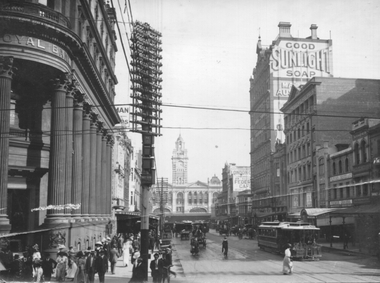
Photograph - Elizabeth St at Collins St, c1910
... The photograph shows Elizabeth St looking south from... The photograph shows Elizabeth St looking south from Collins St ...The photograph shows Elizabeth St looking south from Collins St. The northbound cable tram set has the destination of Royal Park. The photo has the Royal Bank, Flinders St station, and many other buildings. In the view are Griffith Teas, Federal Cafe, Fletcher Chester & Co Grocers and a large sign for Good Sunlight Soap.Yields information about Elizabeth St c1910.Black and White photograph - printed on plain paper.On the rear has pencil number "KM-M-057".cable trams, tramways, collins st, elizabeth st -
 Federation University Historical Collection
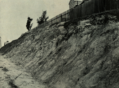
Book, Report on the Ballarat East Gold-Field, 1894 and Ballarat East Gold-Field, 1907, 1894
... of the Geological Survey of Victoria. Photographs include Looking South... Looking South from the Britannia Mullock Heap, View from Sovereign ...The Ballarat Ironworkers' and Polytechnic Association was at the Ballarat School of Mines. In 1907 J.W. Gregory Professor of Geology at Glasgow Univesity, Late Director of the geological Survey of Victoria and Professor of Geology at Melbourne University. W. Dickson was Secretary for Mines and Donald McLeod was the Minister of Mines. in 1894 Ernest Lidgey was the Assistant Geological Surveyor for the Victorian Department of Mines. A.W. Howitt was Secretary for Mines and Henry Foster was the Minister of Mines. Charcoal hard covered report on the Ballarat East Goldfield. The book combines two reports from the Victorian Department of Mines. The 1894 report is 52 pages and includes images and plans. The 1907 Report is number 4 in the Memoirs of the Geological Survey of Victoria. Photographs include Looking South from the Britannia Mullock Heap, View from Sovereign Hill, Golden Point gold discovery site.Stamped "Ballarat Ironworkers' Association School of Mines" Bookplate of the Ballarat Ironworkers' and Polytechnic Association. Written inside front cover: "S.J. Miller, 115 Ascot Street, Ballarat"ballarat ironworkers' and polytechnic association, ballarat school of mines, ironworkers, geology, mining, ballarat east, llanberris, victoria united mine, normanby, north woah hawp, bookplate, s.j. miller, library plate, golden point, gold discovery at golden point, new normanby mine, william baragwanath, new speedwell, britannia united, llanberris co, sulieman pasha, prince regent, dalzell-cum-prince regent, north prince extended, eastern star, f. gray, victoria united gold mine, sovereign hill mine, prince regent mine, britannia mine -
 Charlton Golden Grains Museum Inc
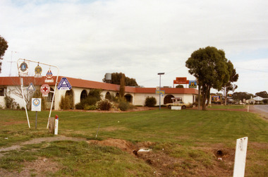
Photograph, Charlton Motel c. 1987
... Colour photograph of the Charlton Motel taken looking south... photograph of the Charlton Motel taken looking south east. The Motel ...The motel was built in the 1960s. Photo is part of a Charlton Shire streetscape series c.1987.Colour photograph of the Charlton Motel taken looking south east. The Motel is a white brick, single-storey building with a red trimmed roof. The verandah and some front windows are arches. There is a large garden bed with shrubs in front of the verandah. On the left are signs for various community organisations - Lions, Rotary, Apex, Young Farmers, Red Cross, and Amity. A cream coloured car is parked in the drive way charlton motel -
 Whitehorse Historical Society Inc.
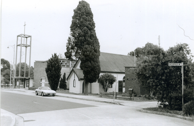
Photograph, Corner Enterprise Way & Edward Street, Mitcham, 2000
... of Enterprise Way & Edward Street looking South towards Whitehorse Road... and negative of corner of Enterprise Way & Edward Street looking South ...Produced as one of a series of 24 prints commissioned by Nunawading & District Historical Society -|Theme: Intersections of Mitcham and Nunawading 2000/2001.|See also Series by P. Simmenauer on the same theme.Black and white photograph - print and negative of corner of Enterprise Way & Edward Street looking South towards Whitehorse Road, Mitcham. L-R: Church Tower [Anglican Church](built circa 1959). Tower surmounts a modern church building in brick and concrete; next door Church Hall 1888 weatherboard construction; Cypress tree; Forster Hall, brick building (circa 1975)forster hall, mitcham, christ church anglican church, church hall -
 Ballarat Tramway Museum
Slide - 35mm slide/s, Noel Simons, Aug. 1971
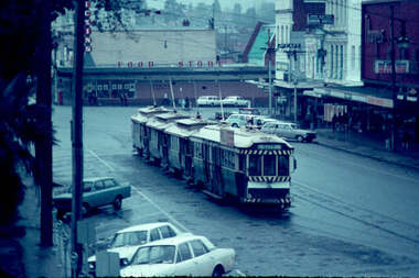
... on a wet Ballarat day. Taken from central median strip, looking... Ballarat day. Taken from central median strip, looking south east ...Plain white cardboard transparency slide of Ballarat No. bogie tram (No. 34) and three single truckers in the City Loop on a wet Ballarat day. Taken from central median strip, looking south east. Has Dickins Food store and shops along the south side of Sturt St. near Grenville St. in the background, including Thomas Jewellers and the Jack Gaffin? Union Hotel"City Loop" and "Aug 1971" in blue ink.tramways, trams, city loop, sturt st, tram 34 -
 Bendigo Historical Society Inc.
Photograph - LANDSCAPE VIEW OF BENDIGO, c2001
... Color photograph. View of Bendigo looking South East from... photograph. View of Bendigo looking South East from the look out ...Color photograph. View of Bendigo looking South East from the look out tower in Rosalind Park. Former Bendigo Post Office on the right side, Courthouse in centre, Town Hall far side of Courthouse and the Shamrock Hotel on far side of Post Office. Physical description: Unmounted photo. Inscriptions/Markings: Bendigo from look out tower, Rosalind Park, April 2001.Willa, Wendybendigo, bendigo streetscape, bendigo central, post office, court house, bendigo town hall, shamrock -
 Mt Dandenong & District Historical Society Inc.
Photograph
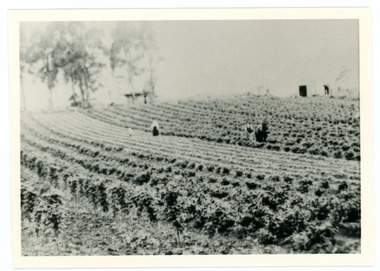
... the Channel O tower stands looking south east towards corner of Ridge... the Channel O tower stands looking south east towards corner of Ridge ...William Dower came with his family to the Mt Dandenong in 1898, taking up a 10 acre allotment. William and hs wife Elizabeth had seven boys (Will, Harry, Bert, Walter, Joe, Edgar, Robert) and four girls (Emmy, May, Ada, Ruby). The property secured by William Dower was known as ‘Cambridge Gardens’ and had a two room slab hut. William and his sons added another five rooms using trees from the property. The family established extensive crops and worked hard for their success. The acreage extended to 30 when the family bought up neighbouring properties.Black and white photograph showing rows of berry crops. Reverse of photograph has handwritten description by John Lundy-Clarke.LOT 10 section 2 of the Village Settlement owned as registered by Dobson, then Bert Dower, then Edgar Dower. Property was named "Bonnie View" and photo was taken from near where the Channel O tower stands looking south east towards corner of Ridge Road and Selwyn Lane taken 1920.bert dower, edgar dower, bonnie view, channel o, dobson, selwyn lane -
 Eltham District Historical Society Inc
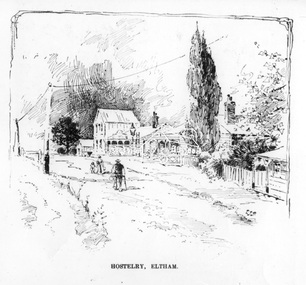
Photograph, The Australasian, Hostelry, Eltham, 2 May 1903
... Looking south along Maria Street (now Main Road, Eltham... melbourne Looking south along Maria Street (now Main Road, Eltham ...Looking south along Maria Street (now Main Road, Eltham) from the John Street intersection, showing the Evelyn Hotel with its two storey "Ball Room", the kerosene road lamp marks the intersection of Pitt and Maria streets. Cross Reference Photo No.(s): SEPP_0626 (Scarce House) The Scarce house can be seen to the right of the Hostelry.This photo forms part of a collection of photographs gathered by the Shire of Eltham for their centenary project book,"Pioneers and Painters: 100 years of the Shire of Eltham" by Alan Marshall (1971). The collection of over 500 images is held in partnership between Eltham District Historical Society and Yarra Plenty Regional Library (Eltham Library) and is now formally known as the 'The Shire of Eltham Pioneers Photograph Collection.' It is significant in being the first community sourced collection representing the places and people of the Shire's first one hundred years.Digital imagesepp, shire of eltham pioneers photograph collection, eltham, evelyn hotel, john street, main road, maria street, hostelry -
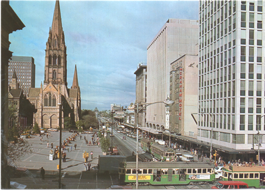 Melbourne Tram Museum
Postcard, Bartel Collectors World, "Swanston and Collins Streets, overlooking City Square", late 1970s
... of Collins and Swanston St looking south. It shows an early version... and Swanston St looking south. It shows an early version of the City ...Photo taken from the Town Hall shows the intersection of Collins and Swanston St looking south. It shows an early version of the City Square. In the photo is St Paul's Cathedral, the Graham Hotel, and the Wales Corner building. Several trams are in the view including W2 596 westbound in Collins St, See reference for the Square History - based on the paving, late 1970s,Yields information about the City Square,Colour postcard by W Bartel of Sydney - NoM301postcards, collins st, swanston st, city square, w2 class, tram 596 -
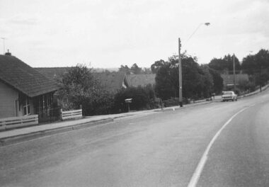 Ringwood and District Historical Society
Photograph, South side of Bedford Road, Ringwood East, taken from outside shops on the corner of Illoura Avenue - 1/9/1974
... Written on back of photograph, "Bedford Rd. looking..., "Bedford Rd. looking at south side towards east from outside shops ...Written on back of photograph, "Bedford Rd. looking at south side towards east from outside shops cnr. Illoura Ave. (As in brochure)" -
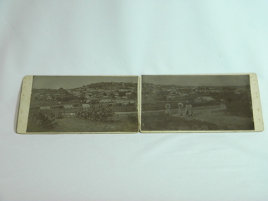 Daylesford & District Historical Society
Photograph Daylesford Panorama, J. J. Crawford, Western Avenue to Wombat Hill woman and two girls c1900, Circa 1900
... , looking South East to Wombat Hill & beyond with many buildings... photos forming panorama of Daylesford township, looking South ...Early panorama of Daylesford circa 1900 with views of Wombat Hill from Western Avenue. Taken by J. J. Crawford of Mitiamo late resident of Daylesford.A unique early view of Daylesford showing large areas of vacant land pre modern development.2 B&W photos forming panorama of Daylesford township, looking South East to Wombat Hill & beyond with many buildings clearly visible. 3 women/girls in foreground. Circa 1900. Mounted on 2 pieces of cardboard, stuck together by sewing red fabrick onto mounting boards. Taken at western Avenue by J. J. Crawford of Mitiamo Victoria photographic studio a late resident of Daylesford. J.J. Crawford Mitiamo (Stamp) Donated to Daylesford & District Historical Society by (J.J. Crawford Mitiamo) (late of Daylesford) D13wombat hill, town views, clothing -
 Clunes Museum
Map - MAPS
... SECTIONS. 656. LOOKING SOUTH. LOOKING NORTH .3 TRANSVERSE SECTIONS.... LOOKING SOUTH. LOOKING NORTH .3 TRANSVERSE SECTIONS, SOUTH CLUNES ...MINING IN CLUNES.1 THE PORT PHILLIP & COLONIAL GOLD MINING CO. CLUNES. NORTH CROSS SECTION AND SOUTH CROSS SECTION. SCALE 1:100 .2 NEW NORTH CLUNES SHEET 2. TRANSVERSE SECTIONS AND LONGITUDINAL SECTIONS. 656. LOOKING SOUTH. LOOKING NORTH .3 TRANSVERSE SECTIONS, SOUTH CLUNES UNITED G.M. CO. No.1 SHAFT, No.2 SHAFT, No.3 SHAFT, No.4 SHAFT..1 ON BACK OF MAP: NORTH PORT PHILLIP X-SECTION 22325N .2 HANDWRITTEN NOTES ON MAP .3 HANDWRITTEN NOTES ON MAPport phillip & colonial gold mining, new north clunes, south clunes united -
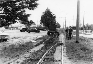 Ballarat Tramway Museum
Photograph - Black & White Photograph/s, The Courier Ballarat, Oct. 1971
... from Albert St, Sebastopol, looking south and how it was done..., Sebastopol, looking south and how it was done - not sure who ...Yields information about the demolition or removal of the track along the Sebastopol line and how it was done.Black and White copy photograph of a newspaper photograph taken by The Courier - published 19/10/1971of Rail being removed from Albert St, Sebastopol, looking south and how it was done - not sure who was doing the work. Collected by Alan Bradley from the Ballarat Courier early 1980's. See Excel file "Record of Ballarat Courier Photos SEC era" (Archive Documents) for source of details.tramways, trams, sebastopol, track removal, closure, rails -
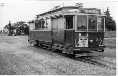 Ballarat Tramway Museum
Photograph - Black & White Photograph/s - set of 4, George Bishop, late 1950's
... in background .3 - looking south along Lydiard St .4 - as for . 2... with cemetery house in background .3 - looking south along Lydiard St ...Set of four Black and white photographs of Ballarat 30 at Lydiard St Nth Terminus late 1950's. .1 - Lydiard St cemetery gates in background .2 - head on photo with cemetery house in background .3 - looking south along Lydiard St .4 - as for . 2 Each photo has destination of Sebastopol and end driver pal of Bourne Liquid Floor Finish. Photos by George Bishop.On the back each photo in ink "SEC Tram No.30 (Ballarat system) / G.Bishop photo "tramways, trams, lydiard st nth, cemetery, tram 30 -
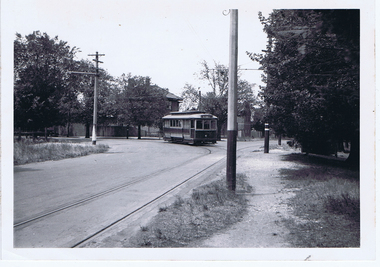 Ballarat Tramway Museum
Photograph - Digital image, Wal Jack, 17/01/1945 12:00:00 AM
... into Macarthur St, looking south east at the View Point terminus. Photo..., turning out of Wendouree Parade into Macarthur St, looking south ...Yields information about the appearance of the View Point area in 1945Digital image from the Wal Jack Ballarat Album of a photograph of No. 20 ex Gardens, turning out of Wendouree Parade into Macarthur St, looking south east at the View Point terminus. Photo Wal Jack taken on 17-1-1945. See image i2 for rear of photograph. See image i3 for hi res scan of print. See image i4 for hi res scan of negativeOn rear of photograph in ink "SEC, Ballarat No. 20 ex Gardens turning out of Wendouree Parade into Macarthur St 17-1-1945" and in top right hand corner, Wal Jack stamp with "71" written in. trams, tramways, view point, wendouree parade, macarthur st, tram 20 -
 Ballarat Tramway Museum
Slide - 35mm slide/s, Wal Jack, 7/04/1962 12:00:00 AM
... west side of Lydiard St. looking south. Photo includes... St. looking south. Photo includes Vauxhall and Morris built ...Photo of 10 trams in Lydiard St., with No. 20 at north end for Australian Railway Historical Society visit on 7-4-1962. Taken from west side of Lydiard St. looking south. Photo includes Vauxhall and Morris built cars. No. 20 fitted with dash canopy lights, small white strip, and has an ad for 'The Age' on front panel. Destination shown is 'Special'. Photo is over exposed.'SEC Ballarat ARHS Specials, 10 trams in Lydiard St. Nth. 7/4/62.' in blue ink.tramways, trams, lydiard st., specials, arhs, tram 20 -
 Melbourne Tram Museum
Photograph - Black and White photograph - mounted, Mathew Irwin, 1991
... blockade of Jan. 1990, looking south along Elizabeth St... during the tram blockade of Jan. 1990, looking south along ...Black and white photograph mounted into a brown card (acid free) surround, titled "Stacked Trams", taken during the tram blockade of Jan. 1990, looking south along Elizabeth St with the Flinders St Station, Elizabeth St clocktower in the far distance. Taken by Mathew Irwin - https://mattirwin.com/ (accessed 3/3/2021) For 600dpi scan see image i2. Note this is copyright photo."Stacked Trams" and "Cc Mathew Irwin '91" in white ink under the photo. Stamped on the rear is "Matt Irwin Photographer Copyright 1993"trams, tramways, elizabeth st, tram blockade, strike, unions, conductors -
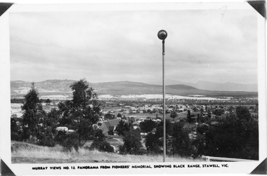 Stawell Historical Society Inc
Photograph, Panorama of Stawell from Pioneer's Memorial, towards the Black Range. Murray Views No.13
... Murray Views No. 13. Panorama over Stawell, looking South... grampians Murray Views No. 13. Panorama over Stawell, looking South ...Murray Views No. 13. Panorama over Stawell, looking South West. Spotlight on Pioneer's Memorial (29,5). Black Range in background, grassland on Big Hill at front of Photo. St Patrick's Church visible, Kinsella House. The larger photo 29.5a is a slightly closer view of same scene and shows the "new" school (corner Patrick & Holt Street) opened in 1934.Two similar views of Stawell. One Murray views looing south west (29.5) and the other a larger photo showing school building beside church (29.5a).Murray Views No.13. Panorama from Pioneer's Memorial, showing Black Range, Stawell, Vic. (on 29.5)stawell, panorama -
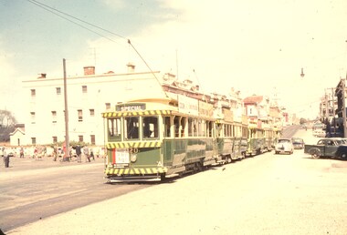
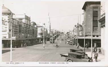
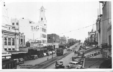 Ballarat Tramway Museum
Postcard, Valentine & Sons Publishing Co, "Moorabool Street Geelong", 1949
... of Moorabool St Geelong looking south. Tram 17 is visible along... of Moorabool St Geelong looking south. Tram 17 is visible along ...Postcard produced by the Valentine publishing company of Moorabool St Geelong looking south. Tram 17 is visible along with the part of another tram in the bottom left-hand corner. In the photo are Bright & Hitchcock, the T&G building, Gray & Murray, the Bank of NSW, Savoia Cafe, and Rockman's stores along with an advertisement for Berger paints. The rear of the card notes it is a genuine photograph.Yields information about the view of Moorabool St c1949Black and white Postcard undivided back, unused. On top right hand rear is "1949" in pencil.tramways, trams, geelong, moorabool st, tram 17 -
 Bendigo Historical Society Inc.
Document - LONG GULLY HISTORY GROUP COLLECTION: FRENCH'S CORNER AND VILLAGE PARLIAMENTS
... and Shoeing Force. At the end of the article is a photo - Looking... is a photo - Looking south from the Blacksmiths Shop up the main ...Titled French's Corner and Village Parliaments. French's Corner was once the meeting place of the old Cornish miners where they used to discuss local and international affairs. Headings of the paragraphs are - Teetotallers - Most of Them, Pre-Federation Days, A Shoemaker's Group, Last of his Group, Smith with Curving Nail and Shoeing Force. At the end of the article is a photo - Looking south from the Blacksmiths Shop up the main street of Long Gully.bendigo, history, long gully history group, the long gully history group - french's corner and village parliaments, manchester arms hotel, french's hotel, mr french, uncle tom foss' shop, phillpot's smithy, a crossley -
 Bendigo Historical Society Inc.
Photograph - BASIL MILLER COLLECTION: TRAMS IN PALL MALL, 1960's ?
... . Looking south down Pall Mall towards City Family Hotel... photo. Cavalcade of trams in Pall Mall. Looking south down Pall ...Black and white photo. Cavalcade of trams in Pall Mall. Looking south down Pall Mall towards City Family Hotel in background of photo. War Memorial on right hand side. Trams appear stationary. Pall Mall - cars parked on right hand side, many cars heading south along Pall Mall. Trees on roadside are bare indicating Winter time, cars in image from 1960's. basil miller, pall mall bendigo, tram cavalcade -
 Bendigo Historical Society Inc.
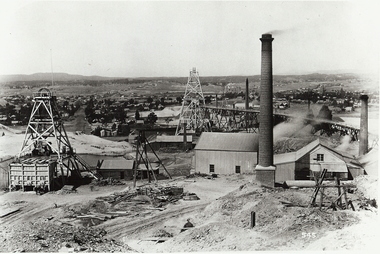
Photograph - NEW CHUM MINE WORKINGS
... Lansell's 222 looking south '..., left Lazarus Mine, right Lansell's 222 looking south ...black and white photo ; ( copy ) view from Chum Hill, poppet heads, buildings and chimneys in middle foreground, residential area in background. On front 545. Back ' mining gold Bendigo Vic. Mine workings - near New Chum Mine. ' not to be reproduced without permission from the National Library. James Lerk 18.2.2000 ; ' view from Chum Hill, left Lazarus Mine, right Lansell's 222 looking south 'organization, business, new chum mine -
 Bendigo Historical Society Inc.
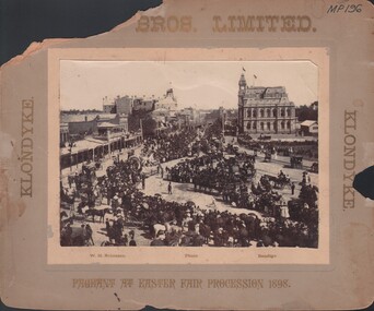
Photograph - EASTER FAIR PROCESSION 1898, 1898
... , showing Cohn Bros. Float in middle foreground. Photo looking.... Float in middle foreground. Photo looking south down Pall mall ...black and white photo: Easter Fair Procession 1898, showing Cohn Bros. Float in middle foreground. Photo looking south down Pall mall towards City Family Hotel in distance. Crowd lining route, horse and jinkers behind. On bottom ' W.H. Robinson, Photo, Bendigo. Across top ' Bros. Limited' Part of top missing , would be 'Cohn Bros Limited' ? Down both sides ' Klondyke' .W.H. Robinsonorganization, society, easter fair procession -
 Ballarat Tramway Museum
Photograph - Colour Print/s, Ron Scholten, early 1960's
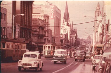
... Colour print of Swanston St Melbourne looking south with W3...Ballarat Tramway Museum South Gardens Reserve Wendouree ...Colour print of Swanston St Melbourne looking south with W3 661 northbound, route 4, showing "City" as a destination at the intersection of Lonsdale St Another W3 is southbound. Has many vehicles in the street, including a Morris Minor and a van with word "Singer" across the front. In the photo is the Foys building, and a sign for the "Victorian Society for Protection of Animals". Photographer - possibly Ron Scholten. Printed on Kodak paper - from a slide.trams, tramways, mmtb, swanston st, tram 661 -
 Kew Historical Society Inc
Photograph - Kew Station 22/4/51, F3, 1952
... , looking south to Barker Station. The photograph, one of 12... of Kew Railway Station, looking south to Barker Station ...The Kew railway was opened in 1887, and diverged from the main (Box Hill–Lilydale) line about half-way between Hawthorn and Glenferrie. From the point of divergence the line was slightly less than one mile long, and it had only one intermediate station — Barker. There were four road over-bridges and two level crossings, including one over the busy Barkers Road. The line supported a passenger and goods service, and was electrified in December 1922, at the same time as the main line to Box Hill. There were a number of peak hour services which ran from Flinders Street station (Melbourne) to Kew, but in 1938 all but one of these were diverted to the Ashburton line, where traffic was growing. This had an adverse effect on Kew traffic, as passengers from Kew needed to cross over a footbridge at Hawthorn to change trains, and the main line trains were usually already crowded by the time they reached Hawthorn. At about the same time the off-peak trains were replaced by road buses. In 1952 all passenger trains were withdrawn, but the road bus service continued for many years. Goods trains were finally withdrawn in 1957, and the railway was dismantled in 1958-59. (Source: Frank Stamford, 'The Hawthorn - Kew Railway')Small black and white snapshot of Kew Railway Station, looking south to Barker Station. The photograph, one of 12, is part of a larger album of newspaper clippings, timetables, tickets and photos relating to the Kew Railway Line, taken and compiled by Lachlan Richardson, while a resident of Kew. The album dates from the 1950s. The album is part of a larger subject file on the Kew Line, compiled over time by members of the Kew Historical Society.kew railway line, transport -- railways -- kew (vic.), kew branch line, kew railway station -
 The Beechworth Burke Museum
Photograph
... Street looking South West. On the left hand side is now what we... Street looking South West. On the left hand side is now what we ...Taken in Beechworth 1859, this photograph depicts Ford Street looking South West. On the left hand side is now what we know as Beechworth Historic precinct and includes The Gold Wardens office being the first building in view followed by The Chinese Protectors office, The Gold Vault and The Courthouse. The Telegraph station is out of shot in this image.his image of Ford Street is the first council chambers copy known to exist.Black and white rectangular photograph. Image is printed on matte photographic paper. Obverse: NO INSCRIPTION Reverse: 2827 AO2827 See Tibbets 'Beechworth Historical Reconstruction page 53" FORD ST BEECHWORTH LOOKING S/WEST 1859burke museum, ford street, council chambers, beechworth historic precinct -
 Ballarat Tramway Museum
Photograph - Black & White Photograph/s, Rose Stereograph Co, Moorabool Street Geelong Vic, c1930
... Postcard, No. P 70, looking south along Moorabool Street... in Moorabool St, from a Rose Series Postcard, No. P 70, looking south ...Photo of Geelong No 4 in Moorabool St, from a Rose Series Postcard, No. P 70, looking south along Moorabool Street at the intersection with Ryrie St. Geelong. Has the Solomon's store, T& G in the background. Photo c1930? Has a Birney tram on the hill. Printed by the Rose Stereograph Co. Original postcard held - see image 2 for pencil notes on the rear about the trams and their routes.Yields information about Moorabool St Geelong in the 1930s.Black and White print of a postcard contained within the Wal Jack Bendigo and Geelong Album, see Reg Item 5003 for more details.On rear in ink "SEC Geelong No. 4 with Birney tram on Moorabool St hill"trams, tramways, geelong, moorabool st, ryrie st, tram 4 -
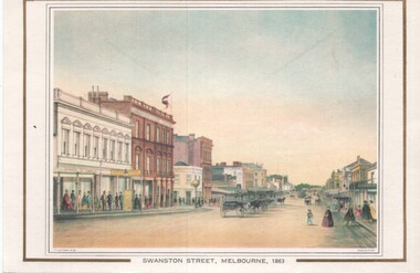 Melbourne Tram Museum
Artwork, other, Swanston Street Melbourne 1863
... - Swanston Street from a point north of Little Bourke St looking... Street from a point north of Little Bourke St looking south ...Colour print of a reproduction of an oil painting - Swanston Street from a point north of Little Bourke St looking south towards the Kings Domain. Reproduced by Kew Cottages and St Nicholas Parent's Association from a original print and lithographed by F Cogne, printed and published by Charles Troedel in his Melbourne Album 1863. Appears to have a number of horse drawn cabs parked in the centre of the street.Yields information about early Melbourne after the start of the gold rush.Reproduction of an oil painting - card - Swanston Street Melbourne 1863melbourne, horse drawn vehicles, swanston st -
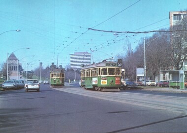 Melbourne Tram Museum
Postcard - St Kilda Road, with W class trams and the Shrine of Remembrance, National View by Murfett Publishing, 1970s
... Postcard - St Kilda Road, view looking south at the Shrine... Postcard - St Kilda Road, view looking south at the Shrine ...Postcard - St Kilda Road, view looking south at the Shrine of Remberance, BP House and on the far right part of the now demolished Prince Henry's Hospital. Trams in the view are W2 345 (Carnegie Route 4) and SW6 913 (City, Route 4). Tram 813 has adverts for Coffey Ford and T&G insurance along with others. The driver of 913 has his cap on an angle.Yields information about St Kilda Road around the Shrine, c1970 and tram services.Postcard colour - St Kilda Road, with W class trams and the Shrine of Remembrance - National View - Murfett publishingtrams, tramways, st kilda road, w2 class tram, sw6 class tram, tram 913, tram 345, shrine of remembrance -
 Brimbank City Council Art Collection
Photograph, Robert Pointon, Twin Pines, 1988
... East of Fairbiarn Road, South Sunshine, looking east... Landscape landscape photograph East of Fairbiarn Road, South ...Local LandscapeEast of Fairbiarn Road, South Sunshine, looking east - AR0002landscape, photograph