Showing 17376 items
matching view-master
-
 Greensborough Historical Society
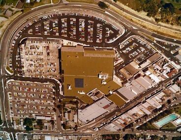
Photograph - Digital image, Early Greensborough Plaza aerial view, 1979c
An aerial view of Greensborough Plaza around the time it opened in the late 1970s. Shows "The Circuit" and carparks.An aerial view of the 'new' Greensborough Plaza circa 1979.Links: 01993.04769 Digital copy of colour photograph.greensborough plaza, the circuit greensborough -
 Eltham District Historical Society Inc
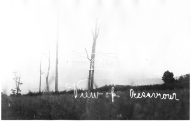
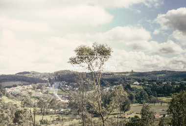
Photograph, View of Reservoir from Kinglake
View is of Yan Yean Reservoir, probably taken from Council land (1970) on Ganglehoffs Road.This photo forms part of a collection of photographs gathered by the Shire of Eltham for their centenary project book,"Pioneers and Painters: 100 years of the Shire of Eltham" by Alan Marshall (1971). The collection of over 500 images is held in partnership between Eltham District Historical Society and Yarra Plenty Regional Library (Eltham Library) and is now formally known as the 'The Shire of Eltham Pioneers Photograph Collection.' It is significant in being the first community sourced collection representing the places and people of the Shire's first one hundred years.Digital image and 4 x 5 inch B&W Negsepp, shire of eltham pioneers photograph collection, kinglake, reservoir, ganglehoffs road, yan yean reservoir -
 City of Ballarat Libraries
Photograph - Card Box Photographs, Florence Breakell & childen at View Point, Lake Wendouree circa 1928
Florence Breakell with Jim and June Brehaut sitting on the wooden promenade at View Point on Lake Wendouree.florence breakell, jim brehaut, june brehaut, view point, lake wendouree, ballarat, costume -
 City of Ballarat Libraries
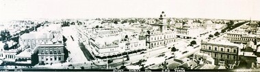
Photograph - Card Box Photographs, Panorama view of Sturt Street, Ballarat circa 1903
Panoramic view of Sturt Street looking south west. The photo was taken from the G.P.O. tower.panorama, sturt street, gpo tower, streetscape, building, public, commerical -
 Stawell Historical Society Inc
Photograph, Salinger's House in Great Western with front on view from road shows Winery and Shed 1959
Salinger's House Great Western. Front on View from road shows Winery and Shed. 1959stawell -
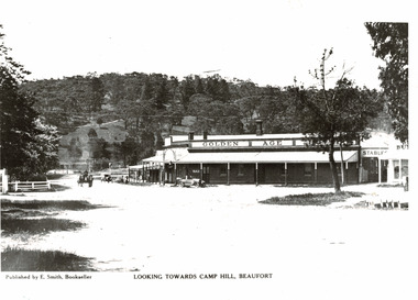 Beaufort Historical Society
Photograph - Beaufort streetscape, View to Camp Hill
View from Livingstone Street Beaufort towards Camp Hill. Shows Golden Age Hotel.Black & White PhotographPublished by E Smith Booksellerbeaufort, historic beaufort streetscape -
 Eltham District Historical Society Inc
Negative - Photograph, View, Bridge Street, Eltham, c.1890
View towards Montmorency Estate from Main Road, Eltham about 1890. Looking down Bridge Street across the bridge (1875). At the corner of Susan Street is the Hill family home. Reproduced in "Montmorency; the farm on the Plenty" by Maureen Jones, 2015, p43 - 'View towards Montmorency Estate from main Road, Eltham, c.1890'This photo forms part of a collection of photographs gathered by the Shire of Eltham for their centenary project book,"Pioneers and Painters: 100 years of the Shire of Eltham" by Alan Marshall (1971). The collection of over 500 images is held in partnership between Eltham District Historical Society and Yarra Plenty Regional Library (Eltham Library) and is now formally known as 'The Shire of Eltham Pioneers Photograph Collection.' It is significant in being the first community sourced collection representing the places and people of the Shire's first one hundred years.Digital image 4 x 5 inch B&W Negshire of eltham pioneers photograph collection, eltham, bridge street, bridge street bridge, hill family home, montmorency, susan street -
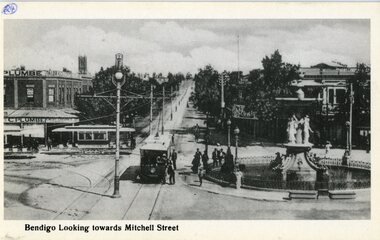 Ballarat Tramway Museum
Postcard, Rose Stereograph Co, 1906 view of Charing Cross, Bendigo, 1990's?
Black and White postcard, c1906 view of Charing Cross, Bendigo looking towards the west - Mitchell St. Has three tram cars in the view, the fountain, centre poles and a tailors shop on the south west corner of the area. Reproduced by the Rose Stereograph Co of Glen Waverley. Photo courtesy of Rod Aikman. Has the Rose Co. symbol on the rear of the car, along with areas for the stamp and address block.Has "24" in a circle in the top left hand corner of the front of the card and on the rear, a "William F Scott" address label on the bottom left hand corner.trams, tramways, bendigo, mitchell st, charing cross -
 Eltham District Historical Society Inc
Slide, View overlooking Diamond Creek, 1907
View overlooking Diamond Creek to the northeast, most likely from near St John's Church, 190735 mm colour positive transparency of a newsprint image taken c.1970 Mount - Kodak Kodachrome Card13diamond creek township -
 Eltham District Historical Society Inc
Slide, View overlooking Diamond Creek, 1970
View overlooking Diamond Creek to the northeast, most likely from near St John's Church, 197035 mm colour positive transparency of a newsprint image taken c.1970 Mount - Kodak Kodachrome Card27diamond creek township -
 City of Ballarat Libraries
Photograph - Card Box Photographs, View of Sovereign Hill before the development of the historical village circa 1960
Shows a south west view towards Sovereign Hill before the establishment of the Ballarat Historical Park Association.sovereign hill, private dwellings, landscape, ballarat, mt pleasant -
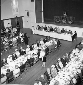 Stawell Historical Society Inc
Photograph, Stawell Town Council Centenary with an Overall view of guests at official luncheon held in town hall 1970
Overall view of guests at official luncheon held in town hall Stawell Town Council Centenary 1970stawell government -
 Stawell Historical Society Inc
Photograph, Stawell Aerial View from a Souvenir photo from the Melbourne Argus Newspaper 1936
Aerial Views of Stawell 1933. Argus newspaper. Looking West along Main Street in centre of photo.stawell -
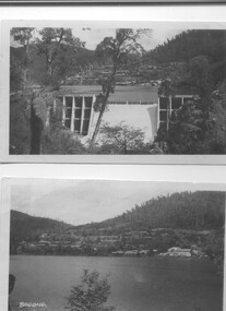 Kiewa Valley Historical Society
Two black and white photos, Photo downstream view of Junction Dam Wall and photo of Bogong Village and Lake Guy, c1950
Photo No. 1 - Junction Dam wall was commenced in February, 1940 and completed in March 1944. Type - reinforced concrete slab and buttress. Height 25.9m, and crest length 121.9m. Lewis Construction company had the original contract, but was replaced by the State Electricity Commission in 1942. Photo No. 2 - Bogong Village was the first village built to house workers and their families working on the Hydro electric scheme. Construction commenced 1940. The single men's quarters are slightly right of centre on the foreshore. Lake Guy was named after a former resident engineer.Shows the type of terrain where the village is located resulting in the tiered layout that was necessary in order to erect housing.set of 2 black and white photos - Photo No. 1 - downstream view of Junction Dam Wall Photo No. 2 - Lake Guy and Bogong Village. Both are on photographic paperPhoto No. 1 - Upper right hand corner, back of photo, handwritten in ink or biro, Bogong 1950 Photo No. 2 - Left lower corner, front of photo in white, Bogong.bogong village, lake guy, secv -
![Photograph, Untitled [Aerial view of construction of CSR Softwood Dartmoor Mill], n.d](/media/collectors/4f729f5597f83e03086015b1/items/655a82f77f3f3810362ecfda/item-media/655a82fa7f3f3810362ef5bf/item-fit-380x285.jpg) Glenelg Shire Council Cultural Collection
Glenelg Shire Council Cultural CollectionPhotograph, Untitled [Aerial view of construction of CSR Softwood Dartmoor Mill], n.d
Port of Portland Authority archives.Front: (no inscriptions) Back: (no inscriptions)port of portland -
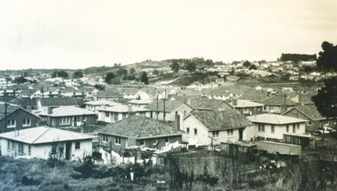
 Ringwood and District Historical Society
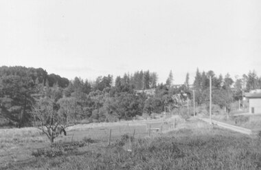
Photograph, View East from Avery Crt North Ringwood. 1981
Written on back of photograph, "24/8/81. View EAST from Avery Crt Nth Ringwood. Wonga Rd in centre below clump of pine trees on skyline. -
 Ringwood and District Historical Society
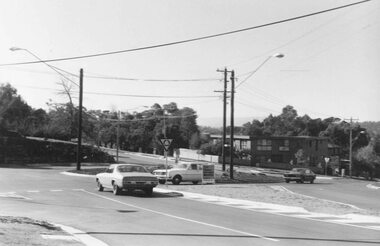
Photograph, View across Oban-Wonga Road roundabout 1981
Written on back of photograph, "1/7/81. View across Oban-Wonga Road roundabout. Wonga Rd. in fore and background. Oban Rd. crossing left to right". -
 Ringwood and District Historical Society
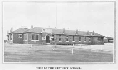
Photograph, Ringwood State School photograph for land sale - Charm-View Estate, Heathmont - 1926
Printed below picture, "This is the district school". Written on back of photograph, "Photo taken from Sub. Div. Plan Land Sale Charm-View Estate, Heathmont. 1926?" -
 Ringwood and District Historical Society
Photograph, View of Glenvale Road near top of first hill from bridge looking north east 1964
See Also #25Written on back of photograph, "Copy of a 1964 view of Glenvale Road near top of first hill from bridge looking north east. Original supplied by Garrett Gundry." -
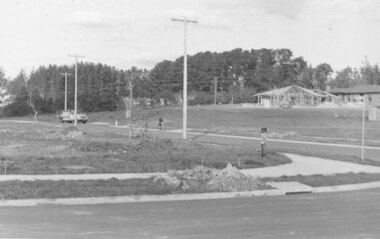 Ringwood and District Historical Society
Photograph, View of corner of Middlebrook Dr and Tortice Drive looking east towards Wonga Rd, North Ringwood. 1981
Written on back of photograph, "24/8/81. View of corner of (Blank) court and Tortice Drive looking east towards Wonga Rd. Thought to be Middlebrook Drive, not a court. -
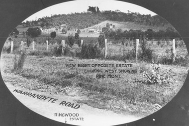 Ringwood and District Historical Society
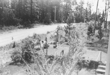
Photograph, View from Warrandyte Road opposite Ringwood Estate looking west, showing Pine Mont. (no date)
Printed onto photograph, "View right opposite estate looking west, showing Pine Mont". Roadway identified as "Warrandyte Road" and "Ringwood Estate" printed at bottom of picture. -
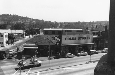 Ringwood and District Historical Society
Photograph, Maroondah Highway Central, Ringwood. Clocktower view of Ringwood Street and Maroondah Highway corner, 1969
Black and white photographImage shows view down Ringwood Street with Loughnans Hill in background, and overlooking telephone exchange. Also shows Post Office, Coles Stores, and State Savings Bank. -
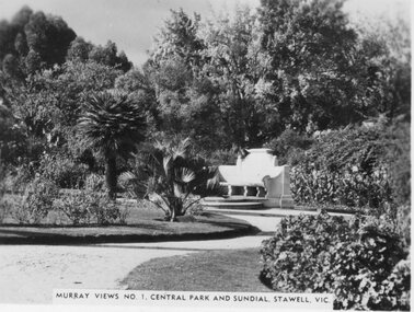 Stawell Historical Society Inc
Photograph, Murray Views, Central Park & Sundial in Stawell c1950 -- Postcard, C. 1950
Sister of Donor visited Stawell in the 1950's when she purchased these Murray Views cards. These cads were produced for sale to touristsSet of 8 Murray Views Postcards No. 1 to 8 C. 1950'sMurray Views No 1 Central Park and Sundial Stawell Victourism postcards -
 Eltham District Historical Society Inc
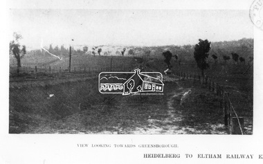
Photograph, The Australasian, View looking towards Greensborough, 1902
Heidelberg to Eltham Railway extension: views along the line Published: "The Australasian", May 31st, 1902, page 1249This photo forms part of a collection of photographs gathered by the Shire of Eltham for their centenary project book,"Pioneers and Painters: 100 years of the Shire of Eltham" by Alan Marshall (1971). The collection of over 500 images is held in partnership between Eltham District Historical Society and Yarra Plenty Regional Library (Eltham Library) and is now formally known as the 'The Shire of Eltham Pioneers Photograph Collection.' It is significant in being the first community sourced collection representing the places and people of the Shire's first one hundred years.Digital imagesepp, shire of eltham pioneers photograph collection, eltham, heidelberg-eltham railway extension -
 Stawell Historical Society Inc
Photograph, Salinger's House in Great Western with front on view from road shows Winery, Shed & the residence at the rear 1959
Salinger's House Great Western. Front on View from road shows Winery and Shed. 1959 Residence at Rear.stawell -
Stawell Historical Society Inc
Photograph, Stawell Aerial View Centred on the Woollen Mills and Stawell Timber Industries 1955
B/W Aerial view of Stawell centred on Woollen Mills and Stawell Timber Industries 7th April 1955.stawell sti -
Glenelg Shire Council Cultural Collection
Photograph, Arial view of CSR Softwoods, Dartmoor, n.d
Port of Portland Authority archives.Front: (no inscriptions) Back: (no inscriptions)port of portland -
Ringwood and District Historical Society
Photograph, View of Ringwood State School builders and plasterers in Nov-1921, Nov-21
Third from the left, top row is Dave Walters. Second from the left is Bert Walters. Both lived in Canterbury Road opposite Heathmont Oval. These plasterers and builders worked on Dame Melba's home later, when the Duke of Gloucester visited Victoria. Dame Melba's home was decorated for the occasion. The plastering was carried out by Walsen (?) Bros. Hardigan, first on the right, back row was a bricklayer who lived in Bedford Road near Illoura Avenue. Acquired c. 2005View of Ringwood State School builders and plasterers in Nov-1921 +Additional Keywords: Walters, David / Walters, Bert / Walsen Bros / Hardigan / Gloucester, Duke of / Melba, Nellie, DameRingwood State School Nov-1921 -
 Rutherglen Historical Society
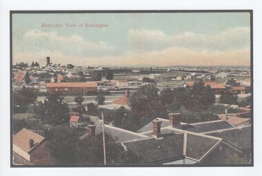
Image, Bird's-eye View of Rutherglen
Original postcard was produced c1906. This print was made in 2017.A colour print of a postcard, downloaded from the State Library of Victoria, showing a view of Rutherglen. A copy of the State Library's record for the original has been printed and pasted to the back of this print. rutherglen -
 Eltham District Historical Society Inc
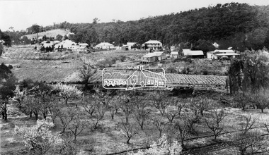
Photograph, View at Hurstbridge, 1924
View of Hurstbridge township overlooking fruit trees in flower in the foregaround and ploughed paddocks ready for crop planting in the middle of the photo.This photo forms part of a collection of photographs gathered by the Shire of Eltham for their centenary project book, "Pioneers and Painters: 100 years of the Shire of Eltham" by Alan Marshall (1971). The collection of over 500 images is held in partnership between Eltham District Historical Society and Yarra Plenty Regional Library (Eltham Library) and is now formally known as The Shire of Eltham Pioneers Photograph Collection.' It is significant in being the first community sourced collection representing the places and people of the Shire's first one hundred years.Digital imagesepp, shire of eltham pioneers photograph collection, hurstbridge, orchard, fruit trees