Showing 1592 items
matching looking south
-
 Canterbury History Group
Photograph - Canterbury, C1900
... Canterbury Road, looking towards the south and Maling Road... Canterbury Road, looking towards the south and Maling Road Photograph ...A black and white photograph of Canterbury taken from Canterbury Road, looking towards the south and Maling Roadcanterbury, canterbury road, maling road, canterbury station, railway line -
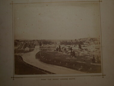 Clunes Museum
Photograph - PHOTOGRAPH LOOK OUT
... THE ROCKS (THE LOOK OUT) ON SCENIC ROAD LOOKING SOUTH. BUTTER...) ON SCENIC ROAD LOOKING SOUTH. BUTTER FACTORY BRIDGE, GOVERNMENT ....1 SEPIA PHOTOGRAPH MOUNTED ON BOARD, TAKEN FROM THE ROCKS (THE LOOK OUT) ON SCENIC ROAD LOOKING SOUTH. BUTTER FACTORY BRIDGE, GOVERNMENT BRIDGE OVER CRESWICK CREEK, BUTTER FACTORY BUILDING, LIGAR STREET TO THE LEFT, FRASER STREET TO THE RIGHT OF PHOTOGRAPH WITH CLUB HOTEL ETC. IN BACKGROUND - SMALL TREES IN WOODEN GUARDS ALONG CREEK. .2 SEPIA PHOTOGRAPH AS ABOVE WITH NOTES WRITTEN ON BORDER POINTING OUT PLACES OF INTERESTphotography, township and bridges, look out scenic road -
 Surrey Hills Historical Society Collection
Photograph, Surrey Hills viewed from 'Quamby' at 293 Mont Albert Road, c 1915, 1915
... Black and white photo looking south down Vincent Street... and white photo looking south down Vincent Street from 'Quamby ...Quamby was built in 1898. From 1900/1903-1924 it was the home of Andrew Sherar and family. From 1924-1960s it operated as Mosgiel Hospital under the direction of Matron Elizabeth Anderson. Until Box Hill Hospital opened most Surrey Hills children were born at Mosgiel or at Nethercourt Hospital in Wilson Street or later in Union Road when Matron Tank moved her hospital here. Mosgiel Hospital was demolished c 1975 after it was sold by Box Hill Hospital. It was replaced by units. Andrew Sherar was conductor of the Wyclif Church choir for many years and was a member of the Melbourne Liedertafel. Isie Sherar was organist at Wyclif Church and also taught piano in Union Road. Connie Sherar was in the Wyclif choir and married Ernest Swan, an elocutionist and orator. Dorothy Sherar was a pianist and accompanist. Elsie Sherar was also in the Wyclif choir and was a soloist; she later moved to Templestowe. Ken Sherar was a boy soprano at St Paul's Cathedral; he later moved to Queensland.Black and white photo looking south down Vincent Street from 'Quamby', located at 293 Mont Albert Road, Surrey Hills. In the centre foreground is a timber house with 2 chimneys and a tiled hip roof. It has a return veranda and is fenced on 2 sides by paling fences and picket fences on the other two. In the background are many more houses. A road lined with power poles runs from the right foreground to the middle distance.quamby, vincent street, edwardian style, topography, andrew sherar, isie sherar, connie sherar, dorothy sherar, ken sherar, elsie wappet -
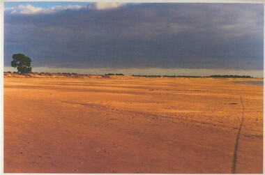 Lake Bolac & District Historical Society
Colour photograph, Fiery Creek, Lake Bolac, 1997-2010 drought
... -2010 drought, looking south. The lake bank exposed... and beach during the 19987-2010 drought, looking south. The lake ...Lake Bolac's eastern lake-bed and beach during the 19987-2010 drought, looking south. The lake bank exposed in this photograph is an aboriginal midden about a likometer across excavated by Dr Peter Coutts in the 1970's. Radio carbon dates of charcoal from the base levels date the midden at 12,000 years old, making this one of two middens with this very early date, the other being on the coast near Warrnambool. lake bolac, aboriginal midden, dr peter coutts -
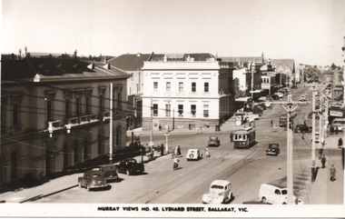 Ballarat Tramway Museum
Postcard, Murray Views, "Murray Views No. 40 Lydiard Street Ballarat Vic", 1948
... North. Looking south. Murray Views No. 40 Postcard. Has Post... and other users in Lydiard St North. Looking south. Murray Views ...Photo shows No. 25 at the intersection of Sturt and Lydiard St, c 1948, and of motorcars and other users in Lydiard St North. Looking south. Murray Views No. 40 Postcard. Has Post Office and the Commonwealth Bank in view. On the rear in a note to Ken Magor, Wal Jack has written: "No. 25 to Sebastopol, turning out of Lydiard St Nth into Sturt St 1948." See item 5307 for a digital image of this view. Yields information about the appearance of Lydiard St and Sturt St intersection from the north-eastern corner and the nature of the vehicular traffic using the street, c1948.Postcard black and white, divided back, with a handwritten note on rear.See image 2 for details of the handwritten note by Wal Jack on the rear. tramways, trams, lydiard st, sturt st, tram 25 -
 Melbourne Tram Museum
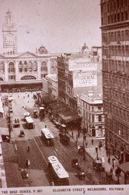
Slide - Black and white reproduction photograph - Elizabeth St Melbourne, 1920c
... Photograph - looking south along Elizabeth Street Melbourne... Photograph - looking south along Elizabeth Street Melbourne ...Photograph - looking south along Elizabeth Street Melbourne to towards Flinders Street station. Has three cable trams in the photo, including one shunting at the terminus. Has signs for the London Cafe and Federal Cafe in the view, along with many horse-drawn vehicles and a few motor cars. There is a telegraph/telephone line on the east side of the street. Original photo by Rose Stereograph Co. P 957 - see reference. Yields information about the south end of Elizabeth St and the cable tram terminus.Kodachrome cardboard duplicate slide - Black and white reproduction photograph - Elizabeth St c1920 "CB9" in penciltrams, tramways, cable trams, elizabeth street, flinders st station -
 Ballarat Tramway Museum
Photograph - Geelong 37 Pakington at Aphrasia Sts, Keith Kings, Jan. 1956
... of Pakington St and Aphrasia St looking south from the passing loop... of Pakington St and Aphrasia St looking south from the passing loop ...Photo shows the track layout and operation at the corner of Pakington St and Aphrasia St looking south from the passing loop. Shows Geelong tram 37, ex Chilwell swinging out before entering the loop. Photographer notes the Newtown turns right at this location shown in the trolley wire. The Municipal Hall and fire station tower are on the right. Photo by Keith Kings 8/1/1956, photo number Q(w)(7). Yields information about the junction of the Chillwell and Newtown tram routes in Geelong.Black and white photograph with notes on rear.See rear image and context.trams, tramways, pakington st, geelong, tram 37, newtown, aphrasia st -
 Bendigo Historical Society Inc.
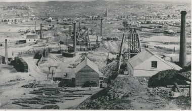
Photograph - MINING AREA VIEW FROM NEW CHUM HILL, 1875
... on front 'Looking South from New Chum Hill in early 1970's... Methodist Church C distance. Inscriptions: typed on front 'Looking ...Black and white photograph. View overlooking mining area from New Chum Hill in the early 1870's showing four poppet legs and at least 9 chimneys (small chimneys and poppets at L distance). Golden Square Methodist Church C distance. Inscriptions: typed on front 'Looking South from New Chum Hill in early 1970's. The rich :Lazarus New Chum: in foreground. Other rich New Chum Mines in background'N J Caireplace, mining site, see also 2001.003.01 -
 Ballarat Tramway Museum
Photograph - Black & White Photograph/s, Wal Jack, 1935
... . (north side) tram line, looking south. Has Town Hall and Myer...Ballarat Tramway Museum South Gardens Reserve Wendouree ...Black and white photograph of the former Phoenix Foundry railway line in Armstrong St. Ballarat crossing the Sturt St. (north side) tram line, looking south. Has Town Hall and Myer (formally Snows) building in the background, along with a tram stop on the corner. Track has been dug out, exposing the sleepers and one tie bar. Has road barriers in background. Photo taken1935, during the reconstruction of the tramway system. On Velox photo paper.On rear in top right hand corner in blue ink "12004". Above main writing in pencil is the number "74". On bottom half in light black ink "The old piece of Rly line in Armstrong St. crossing Sturt St. tram line Ballarat (1935)" In Wal Jack's handwriting.trams, tramways, phoenix foundry, armstrong st, sturt st, railway siding -
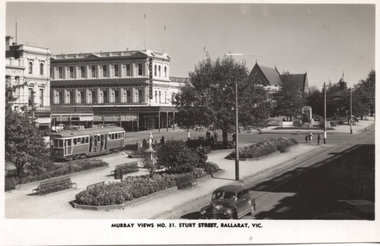
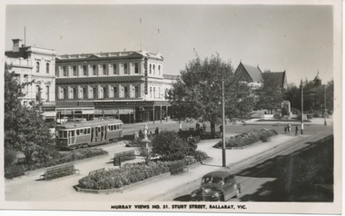 Ballarat Tramway Museum
Photograph - Digital image, Murray Views, Murray Views No. 31 Sturt Street Ballarat Vic, c1950
... Ballarat Vic" , photo looking south west at corner of Doveton... looking south west at corner of Doveton and Sturt St ...Yields information the appearance of Sturt St and Doveton about 1950 with an SEC bogie tram in the photograph.Digital image from the Wal Jack Ballarat Album of a black and white postcard, titled "Murray Views No. 31, Sturt Street Ballarat Vic" , photo looking south west at corner of Doveton and Sturt St with the Harry Davies store in the background. Bogie tram No. 22 is outbound in the street. Has many people in the median strip. Photo c1950. Published by Murray Views, Gympie Queensland - real photo. For rear of postcard - see image i2.trams, tramways, sturt st, doveton st, tram 22 -
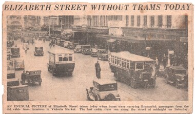 Melbourne Tram Museum
Newspaper, The Herald, "Elizabeth Street without Trams Today", 30/09/1935 12:00:00 AM
... Trams Today". Has a photo of two buses at Bourke St looking... buses at Bourke St looking south. Timeline gives the closure ...Newspaper Clipping - from The Herald 30/9/1935, about the operation of Elizabeth St by buses titled "Elizabeth Street without Trams Today". Has a photo of two buses at Bourke St looking south. Timeline gives the closure of the cable line as 29/9/1935. See Reg Item 1812 about the re-opening of Elizabeth St for electric trams. Newspaper not known at the time of cataloguing could be The Herald, as it mentions "today" in the photo caption.trams, tramways, elizabeth st, cable trams, closure, flinders st station, conversion, buses, tram 744 -
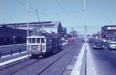 Melbourne Tram Museum
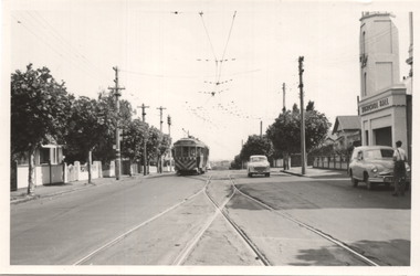
Slide - Set of 2, Keith Caldwell, 15/03/1962 12:00:00 AM
... advert on the right hand side. .2 - View looking south... advert on the right hand side. .2 - View looking south ...Set of two Agfa Colour slides, cardboard mounts, by Keith Caldwell dated 13 March 1962 of: .1 - W2 247 southbound in Kingsway (Domain Road, Route 55) with adverts for White Crow sauce. The large Austral Otis facility on the left hand side and a Dunlop advert on the right hand side. .2 - View looking south on Kingsway where the two roads part with a tram outbound. (I won't ask how this photo was done but it was).trams, tramways, w2 class, kingsway, south melbourne, route 55, tram 247 -
 Bendigo Historical Society Inc.
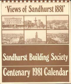
Document - SANDHURST BUILDING SOCIETY CENTENARY 1981 CALENDAR
... Hotel, Pall Mall; panorama from Post Office Tower looking north... Hotel, Pall Mall; panorama from Post Office Tower looking north ...Buff Paper, Sepia Text & Illustrations 7 Pages Views of Sandhurst 1881 Calendar Images: Beehive Chambers and Mining Exchange Hotel, Pall Mall; panorama from Post Office Tower looking north to White Hills; Sandhurst Post Office Pall Mall; Sandhurst Railway Station (opened 1862) and Quarry Hill;Alexandra Fountain, Charing Cross, (opened 1881); panorama from Post Office Tower looking south to Golden Square.bendigo, history, sandhurst building society calendar -
 Bendigo Historical Society Inc.
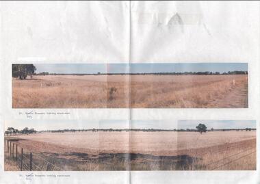
Photograph - Kangaroo Flat Gold Mine Collection: photos of Woodvale site, Daly property, pre dam construction, 1986
... photograph is titled 23. Daly property looking south-east. Bottom... of bottom photo. Top photograph is titled 23. Daly property looking ...Photographs taken at the time of the purchase by Western Mining Corporation of the property owned by G.P. Daly of Raywood Road, Woodvale, in 1986. The intent of the purchase was to provide land for the Woodvale ponds. Land size was 16 acres, known as Allotment 13, Section 3, Parish of Nerring. Paper with two colour photographs attached, each of three photos joined to show landscape view, of the property purchased from G.P Daly by Western Mining Corporation. Photographs show rural land, grassy paddocks with tree line in background. Barb wire fence visible in foreground of bottom photo. Top photograph is titled 23. Daly property looking south-east. Bottom photograph is titled 24. Daly property looking north east. woodvale, g.p. daly, western mining corporation, purchase -
 Eltham District Historical Society Inc
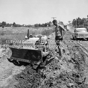
Negative - Photograph, J.A. McDonald, Eltham, Susan Street, Jan. 1961
... January 1961 Looking south Brown excavating Brougham... melbourne January 1961 Looking south Brown excavating Brougham ...January 1961 Looking south Brown excavating Brougham to Dalton (present-day Withers Way) F. Woods Consolidating showing soft fill over culvert after 9 months Just south of Brougham Street. To the immediate left is the present-day car park for the Elham Leisure Centre. The house on the left is immediately opposite Cromwell street and adjacent to the southwest corner of the Leisure Centre buiding (where the Williams house sits hidden from view)Record of various Shire of Eltham infrastructure works undertaken during the period of 1952-1962 involving bridge and road reconstruction projects, sometimes with Eltham Shire Council Project Reference numbers quoted. It was during this period that a number of significant improvements were made to roads and new bridges constructed within the shire that remain in place as of present day (2022). In many situations, the photos provide a tangible visible record of infrastructure that existed throughout the early days of the Shire. The album was put together by or under the direction of the Shire Engineer, J.A. McDonald.shire of eltham, infrastructure, 1961-01, cromwell street, eltham leisure centre, road construction, susan street -
 Eltham District Historical Society Inc
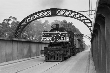
Photograph, Steam locomotive J-500 and goods train crossing the Echuca-Moama Road Rail Bridge, November 1963, 1963
... Looking south towards Echuca, Victoria Image dated... melbourne Looking south towards Echuca, Victoria Image dated ...Looking south towards Echuca, Victoria Image dated as November 1963 based on same image in Port of Echuca collection (print 19.5 x 24.5cm) On reverse in blue pen:" Photo by: George L. Coop Nov 1963". In red pen top left hand corner"Ch 11, (circled number )1. In pencil circled: "35". In pencil : " J Class. Intro Scotland 1948 early 50s." https://victoriancollections.net.au/items/59deb0d421ea6e12dc488c2fDigital TIFF file Scan of 35mm Ilford FP3 black and white negative transparencyechuca-moama road rail bridge, george coop collection, goods train, j-500, j-class steam locomotive (vulcan foundry) -
 Kiewa Valley Historical Society
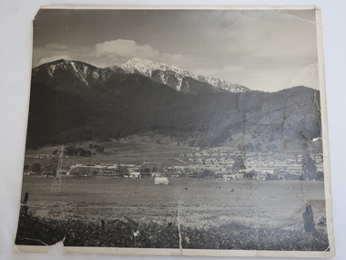
Photo - Mt Beauty c1948, Early photo of Mt Beauty Townhip c1948
... Scheme. Mt Beauty township looking south east from Hollond's... looking south east from Hollond's property c1948. Only one ...Mt Beauty was constructed by the State Electricity Commission of Victoria to house employees of the Kiewa Hydro Electric Scheme. Mt Beauty township looking south east from Hollond's property c1948. Only one transmission line has been built.In the foreground are houses in Simmond's Creek Road. Some houses in North Beauty. The town is still under construction - not all roads have been made and houses haven't any garden around them.This is an early photo of Mt Beauty during construction of the town.d It shows a few houses in Simmonds Creek Road. Large black and white photo of Mt Beauty township with snow on the mountains in the background.mt beauty township 1948, mt beauty construction, simmonds creek road -
 Ballarat Tramway Museum
Postcard, Murray Views, "Murray Views No. 31 Sturt Street, Ballarat Vic", 1948
... Photo features the corner of Sturt and Doveton St, looking... of Sturt and Doveton St, looking South West. Has SEC Tram 22 ...Photo features the corner of Sturt and Doveton St, looking South West. Has SEC Tram 22 westbound. Has the Harry Davies "Big Store" in the view, along with the Gardens in the central median strip. Note written by Wal Jack and card sent to Ken Magor of Newcastle - "Ballarat 1948, Bogie Tram No. 22 to "Gardens via Sturt St West at Doveton St. Photo taken between Armstrong & Doveton Sts, looking west."Yields information about Ballarat 's 29 decorated for the 1939 Ballarat Floral Festival and its appearance and its use and publicity and demonstrates its colours of the flowers used.Postcard black and white, plain back, with a handwritten note on rear.See image 2 and notes for details of the handwritten note. tramways, trams, sturt st, tram 22, doveton st. -
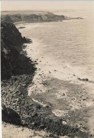 Phillip Island and District Historical Society Inc.
Photograph, Bryant West
... Photograph from cliff top of rocky south coastline looking... Island local history photography photographs coastline - south ...One of a collection of over 400 photographs in an album commenced in 1960 and presented to the Phillip Island & Westernport Historical Society by the Shire of Phillip IslandPhotograph from cliff top of rocky south coastline looking easterlylocal history, photography, photographs, coastline - south coast, south coast, cliffs, south coast phillip island, john jenner, bryant west -
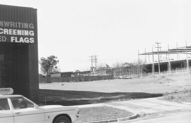 Ringwood and District Historical Society
Photograph, Construction work at Target Square, NE corner of Maroondah Hwy and New Street, Ringwood - 1981, 1981
... -6-81. Looking south from Brambles across Charter St. west... on right below Target." - V134b "30-6-81. Looking south from ...Two views of Target Square shopping complex building under construction.Written on back of photographs - V134a "29-6-81 View from Verstegen's no - New St across Brambles lot at the centre of Target building cnr of Charters-New St on right below Target." - V134b "30-6-81. Looking south from Brambles across Charter St. west end of Target. New St. just out of picture right". -
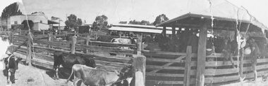 Ringwood and District Historical Society
Photograph, Ringwood Market and Saleyards 1914
... . looking south east towards corner of Ringwood St. and Maroondah... Market. Taken from Charter St. looking south east towards corner ...Black and white photograph (3 copies including original copy in poor condition)Typed below one photograph: "Ringwood Market and Saleyards. Now the site of the new Ringwood Market. Taken from Charter St. looking south east towards corner of Ringwood St. and Maroondah Highway. Old Coolstores in background on left were on Wantirna Rd. - 1914". Typed below another copy: "Ringwood Market - Corner Ringwood St. and Main St. - 1914". -
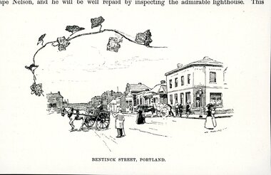 Glenelg Shire Council Cultural Collection
Artwork, other - Illustration, n.d
... corner, looking south towards Macs Hotel. Scene depicts street... corner, looking south towards Macs Hotel. Scene depicts street ...Illustration. Taken and cut from a book. Image is not bordered. View of Bentinck Street Portland Victoria from old London corner, looking south towards Macs Hotel. Scene depicts street life, horse and carts, a man in a top hat, coat and walking cane points south. Two lady's in dresses with an umbrella talk on the corner and various individuals gather out the front of the Old London. Trailer of ivy, top left section. Printed bottom middle BENTINCK STREET, PORTLAND.Front: 'BENTINCK STREET, PORTLAND' - printed, lower edge.bentinck street, city of portland, old london -
Glenelg Shire Council Cultural Collection
Print - Contact Prints - Portland, 1960-1970
... : Cnr Bentinck and Gawler Streets looking south. Post office... Streets looking south. Post office on left, Mac's Hotel right ...Set of 6 contact prints from glass plate negative. Top 2: Cnr Bentinck and Gawler Streets looking south. Post office on left, Mac's Hotel right, crowd of people in intersection . Slight difference in two prints. Middle 2: Several men at lighthouse, next to wall. Photo on left, playing leap frog, photo on right men appear to be dancing. Bottom 2: Stereoscopic prints of waves breaking on rocks, group of people on rocks watching. -
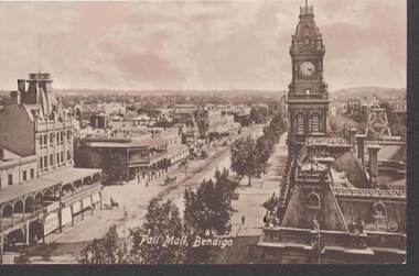 Bendigo Historical Society Inc.
Postcard - PALL MALL, BENDIGO
... Postcard, sepia image of Pall Mall Bendigo, looking south... Bendigo, looking south. Post Office and Law Courts on RH side ...Postcard, sepia image of Pall Mall Bendigo, looking south. Post Office and Law Courts on RH side, poppet head behind, trees on side of road, shopfronts on LH side. Shamrock Hotel on corner of Williamson St. and Pall Mall. Building on opposite corner has ornate lacework on verandah facing Pall Mall. 3000,340 JV in small print on Rh side. On bottom of card: 'Pall Mall, Bendigo' On rear: The Valentine & Sons, Publishing Co., Ltd., Melbourne.bendigo, pall mall, post office -
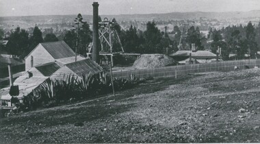 Bendigo Historical Society Inc.
Photograph - LANDSCAPE VIEW OF BENDIGO: GREAT EXTENDED HUSTLERS MINE , CAMP HILL SCHOOL IN CENTRE
... looking south, Moore St., just north of mine'. James Lerk ' From... - 'Great Extended Hustlers Freehold looking south, Moore St., just ...Black and white photo: landscape view of Bendigo valley looking towards One Tree Hill in distance. Great Extended Hustlers timber mine buildings, chimney and poppet head in foreground, trees middle ground, One Tree Hill in background. On back 'Mng10' In pencil - 'Great Extended Hustlers Freehold looking south, Moore St., just north of mine'. James Lerk ' From Hustlers Hill looking over Bendigo to One Tree Hill' late 19C, early 20C ?bendigo, gold mining, great extended hustlers, great extended hustlers mine, mining, one tree hill, camp hill primary school -
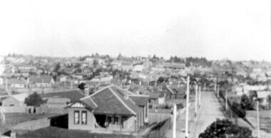
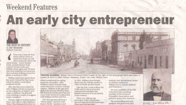 Ballarat Tramway Museum
Newspaper, Dot Wickham, "An early city entrepreneur", 5/03/2005 12:00:00 AM
... and other activities. Features a photo of Lydiard St Nth looking... of Lydiard St Nth looking south from the railway level crossing ...Yields information about William Irwin, Irwins Provincial Hotel and the tram line in Lydiard St Nth.Newspaper clipping from The Courier, 5 March 2005, titled "An early city entrepreneur" written by Dot Wickham about William Irwin, the proprietor of Irwin's Provincial Hotel. Gives a brief history of William Irwin, his Ballarat hotels, his local and other activities. Features a photo of Lydiard St Nth looking south from the railway level crossing with the horse tram lines in the photograph and Irwins Provincial Hotel on the right hand side, before reconstruction to a two story building.hotels, lydiard st nth -
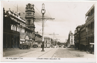 Ballarat Tramway Museum
Photograph - Digital image, Rose Stereograph Co, c1930
... Series postcard No. P 1787, of Lydiard St North looking south...Ballarat Tramway Museum South Gardens Reserve Wendouree ...Yields information the appearance of Lydiard St north, centre poles and buildings.Digital image from the Wal Jack Ballarat Album of Rose Series postcard No. P 1787, of Lydiard St North looking south from near Mair St. shows the centre poles prior to their removal. A number of motor cars are parked in the street, a dog on the right hand side, and ESCo tram has just rounded the corner and about to climb the small hill. Published by Rose Stereograph Co., Armadale Victoria. For rear of postcard - see image i2.in pencil on rear "Old type of electric tram"trams, tramways, esco, lydiard st, poles -
 Port of Echuca
Black and white photograph, 04/03/1984
... .. Photograph taken from the river looking south west as the Adelaide... from the river looking south west as the Adelaide enters ...Photograph related to no.P000041, P000045 - P000048 of P. S. Adelaide re-floating. Copyright held by Riverine Herald newspaper. Original and negatives held by Riverine Herald.. Photograph taken from the river looking south west as the Adelaide enters the water backwards, from the soil ramp . The right hand side of the photograph is in shadow so is very dark. 2 people can be seen on the deck with possibly another boat moored beside the Adelaide and a small motor boat to the left of that.A significant social and historical event in Echuca as many local community groups had committed many hours and much money to re-float the Adelaide to add it to the stocks for the development of the Port of Echuca as a major tourist attraction for the region.Black and white photograph of re-floating of the P. S. Adelaide in the river, possibly still partly on soil ramp. Deep shadows on the right prevent detail of front of the boat and much of the right hand bow. There are spectators in a small motorboat on left of the Adelaide and possibly another boat coming along the side of the Adelaide (2 people can be seen on the left hand side of the Adelaide). 2 people are on the deck of the Adelaide.p. s. adelaide, echuca,victoria,re-floating of the p. s. adelaide. riverine herald newspapers, -
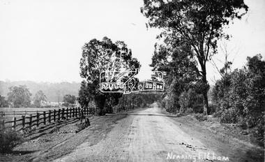 Eltham District Historical Society Inc
Photograph, Tom Prior, Nearing Eltham, from Research, Vic., c.1905, c.1905
... View looking south along the main road from Research... melbourne View looking south along the main road from Research ...View looking south along the main road from Research to Eltham Part of a presentation, "Roads and Byways of the Shire of Eltham", by Russell Yeoman to the 12 September 1990 Society meeting. Slides shown inclyuded copies of old photos and recent images ranging from the suburban streets of Eltham and Montmorency to the mountain roads of Kinglake. In the byways category are views of some iof the Shire's bicycle paths including then recently completed sections of the Main Yarra Trail at Lower Plenty.This photo forms part of a collection of photographs gathered by the Shire of Eltham for their centenary project book,"Pioneers and Painters: 100 years of the Shire of Eltham" by Alan Marshall (1971). The collection of over 500 images is held in partnership between Eltham District Historical Society and Yarra Plenty Regional Library (Eltham Library) and is now formally known as the 'The Shire of Eltham Pioneers Photograph Collection.' It is significant in being the first community sourced collection representing the places and people of the Shire's first one hundred years. The Reynolds family were early settlers in Research. The Reynolds/ Prior collection of photographs were taken by Tom Prior, the maternal uncle of Ivy Reynolds, around 1900 and the 60 photos in the album give a fine overview of many of the landmarks of Research and Eltham over 100 years ago. lvy lived in the family home for many years at 106 Thompson Cres Research. Ivy's father, Ernst Richard Reynolds and grandfather, Richard Reynolds, lived at the same address. Ivy's father Richard worked for Mr. Trail on his property in Research. Reynolds Road is named after the family. Mr Tom Prior (wife Eva) worked at the Melbourne zoo. He was very innovative and made his own camera, using the black cloth hood to exclude the light. The photographs are a reminder of the rural nature of Research and Eltham and its rich heritage.Digital image (Neg missing)shire of eltham pioneers photograph collection, eltham, main road, research (vic.), reynolds prior collection -
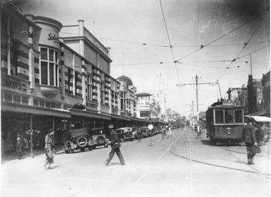 Ballarat Tramway Museum
Photograph - Geelong 4 - Moorabool St, late 1930s
... Streets is looking south along Moorabool St. Shows Geelong tram... of Moorabool and Malop Streets is looking south along Moorabool St ...The photo taken at the corner of Moorabool and Malop Streets is looking south along Moorabool St. Shows Geelong tram 4 with the destination of North, about to turn into Malop St with several passengers boarding the tram. In the background is a safety zone sign, the Solomons store, the T&G building, and many angle-parked motor cars. The T&G building is finished. The bar traffic lights don’t appear to be at the Moorabool and Ryrie St corner yet so the photo was taken between 1934 and 1939Yields information about Geelong late 1930s and tramway operations.Black and white photograph - plain back.geelong, moorabool st, malop st, tramways, tram 4, safety zone