Showing 24911 items
matching ocean
-
 Ballarat Heritage Services
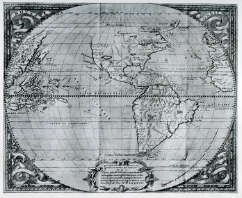
Map, Map Published at Paris, 1587, 1527
This map shows a portion of New Guinea, but the plae occupied by Austrlai was left as open ocean.Copy of a map from 'A Short HIstory of Australia' by Ernest Scott.map, paris map, new guinea, early australian mapping -
 Disability Sport & Recreation Victoria
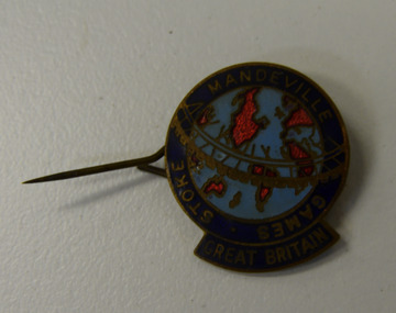
Lapel pin, Stoke-Mandeville Games - Great Britain lapel pin
Round lapel pin.Image of the map of the world, light blue oceans, bright red abstract outlines of continents. Surrounded by navy blue border with STOKE MANDEVILLE GAMES GREAT BRITAIN written in gold.stoke-mandeville games -
 Bendigo Military Museum
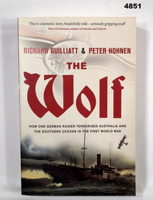
Book - BOOK, WW1 NAVAL HISTORY, GUILLIATT Richard & HOHNEN Peter, " THE WOLF', 2009
"THE WOLF' How one German raider terrorised Australia and the Southern Oceans in the First World War.Soft cover book. Soft cover - cardboard, red and black print on front, spine and back. Cover - colour illustrated - front - top German symbol, bottom, ship at sea. Back - sepia photograph - sailor and girl. 366 pages - cut, plain, off white paper. Illustrated black and white photographs and maps.Nilbook, ww1, naval operations -
 Phillip Island and District Historical Society Inc.
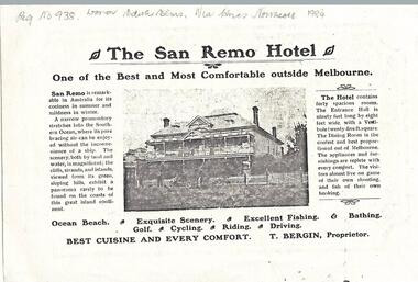
Newspaper clippings, 1903
Donated by Miss Edith Elms via Chrisy Northcote. Show the development of San Remo as a recreational area in 1903.Photocopy of San Remo Hotel advertisement inserted by T Bergin - Proprietor - undated, listing activities - ocean beach, exquisite scenery, excellent fishing, bathing, golf, cycling, riding, driving. Photograph of San Remo Hotel top middle.local history, documents, newspapers, san remo, local area development by europeans, black & white newspaper clipping, advertisement, newspapers san remo -
 Glenelg Shire Council Cultural Collection
Photograph - Photograph - Portland, n.d
Con Kroker Collection -
 Glenelg Shire Council Cultural Collection
Photograph - Photograph - Early Shipping: Ocean / Railway Pier, n.d
Port of Portland Authority Archivesport of portland archives, railway pier, ocean pier -
 Lakes Entrance Regional Historical Society (operating as Lakes Entrance History Centre & Museum)
Photograph
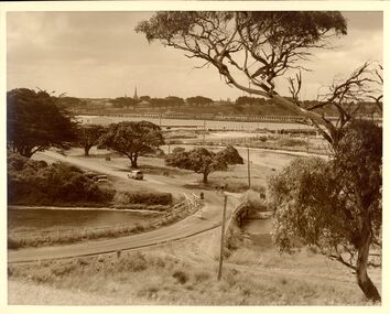
Also one black and white copy 9 x 15Sepia photograph showing wooden Western pier at entrance from ocean into the Gippsland Lakes, with dunes in background foreground shows top ridge of roof of rocket shed on left and shipwreck bell on far right foreground. Lakes Entrance Victoriawaterways, jetties, township -
 Lakes Entrance Regional Historical Society (operating as Lakes Entrance History Centre & Museum)
Photograph, Phillips, Miss L, 1920c
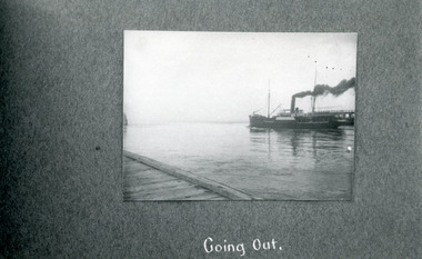
Black and white photograph showing SS Wyralla going out the entrance from Gippsland Lakes to ocean - Bass Strait. Eastern pier boardwalk on left foreground, part of western pier showing behind steamer, at Lakes Entrance, Victoria.Going Outwaterfront, township, settlement -
 Lakes Entrance Regional Historical Society (operating as Lakes Entrance History Centre & Museum)
Photograph, 1920c
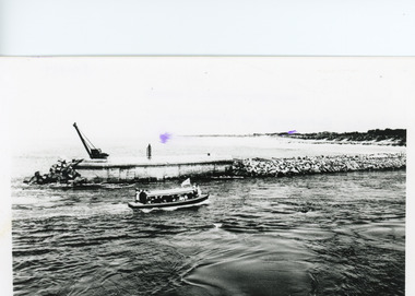
Black and white photograph showing entrance to Gippsland Lakes from ocean - Bass Strait. Photo shows rebuilt western pier with crane on end of pier, loose rocks. Launch - possibly Peels 'Blackbird' in the entrance. Lakes Entrance Victoriatownship, jetties, islands, boats and boating -
 Lakes Entrance Regional Historical Society (operating as Lakes Entrance History Centre & Museum)
Photograph, 1999
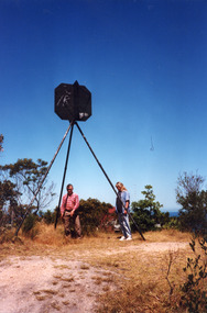
Lakes Entrance Grid reference, Cunninghame 8522.3.4 896.082, on ten acre site with trig point, it is from this point that all the survey for the surrounding areas was undertaken. Part of the Vic Geodetic Survey initiated in 1860 by Ellery Survey started from triangulation base in Werribee. (Grid ref B'dale 8422)Colour photograph of the Victoria Geodetic Survey Triangulation Station, Trig Station, situated off Ocean View Parade, Merrangbaur Hill. Location is indicated by ground point and standing structure, situated on an elevated bush block. Lakes Entrance Victoriahistoric buildings -
Lakes Entrance Regional Historical Society (operating as Lakes Entrance History Centre & Museum)
Photograph, Lakes Post Newspaper, 1/05/1993 12:00:00 AM
Also black and white photograph of two adults and three children watching activities of the fishing fleet at the wharf 04306.1 11.5 x 11.5 cmBlack and white photograph of part of an aircraft engine dredged up from the ocean floor four nautical miles west of the Entrance by fishing boat Anne Liese, skipper Matt Jenkins pictured on Eastern Wharf Lakes Entrance Victoriaboats and boating, fishing industry, islands -
Lakes Entrance Regional Historical Society (operating as Lakes Entrance History Centre & Museum)
Photograph, Lakes Post Newspaper, 1/10/1994 12:00:00 AM
Black and white photograph of staff of Ocean Beach Service Station Tony Kazakes Manager, Kim Morris, Simon Hosemans Sean Rafferty Simon Scott Andrew McNamara named, corner of Esplanade and Myer Street Lakes Entrance Victoriabusinesses -
 The Beechworth Burke Museum
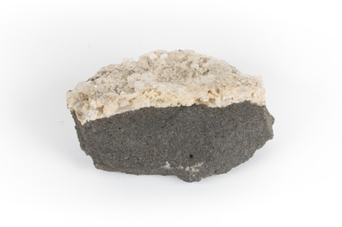
Geological specimen - Hyalite in Basalt
According to the 1912 Department of Mines Bulletin of the Geological Survey of Victoria, basalt covers a considerable portion of the Macedon area including Mount Macedon. Basalt is the most common form of rock underlying the earth's surface and is found in three kinds of rock forming environments: ocean divergent boundaries, oceanic hotspots, and mantle plumes and hotspots beneath continents.This specimen is part of a larger collection of geological and mineral specimens collected from around Australia (and some parts of the world) and donated to the Burke Museum between 1868-1880. A large percentage of these specimens were collected in Victoria as part of the Geological Survey of Victoria that begun in 1852 (in response to the Gold Rush) to study and map the geology of Victoria. Collecting geological specimens was an important part of mapping and understanding the scientific makeup of the earth. Many of these specimens were sent to research and collecting organisations across Australia, including the Burke Museum, to educate and encourage further study.A solid mass, geological specimen in shades of grey and white. Hyalite is a colourless variety of opal. It occurs as globular and botryoidal masses and irregular crusts in volcanic and pegmatite environments where the silica deposits from the gas phase. Basalt is dark in colour, fine-grained igneous rock composed of plagioclase and pyroxene minerals. It is commonly formed as an extrusive rock, such as lava flow. It is one of the most common forms of rock underlying the earth's surface.burke museum, geological specimen, department of mines, geological survey of victoria, basalt, mount macedon, beechworth -
Glenelg Shire Council Cultural Collection
Photograph - Photograph - aerial view of Portland, c. 1954
Black and white aerial photograph of coastline around Portland. Black border, scale all sides, 5 rows of 3 't' at regular intervals. Bottom half ocean, top half land, separated by beach, further left than 8471Front: '607 - 90 ' - handwritten, white, borderaerial photography, central portland, portland harbour, south west coastline -
Glenelg Shire Council Cultural Collection
Photograph - Photograph - Early Shipping: Ocean/Railway Pier, n.d
Port of Portland Authority Archivesport of portland -
 Lakes Entrance Regional Historical Society (operating as Lakes Entrance History Centre & Museum)
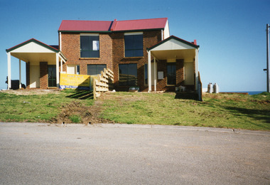
Photograph, Holding M, 2000
'For Sale' sign in yardColour photograph of two semi-detached houses built of site previously part of Merrangbaur, first family residence. Built of brick, colour bond roof, front of houses facing ocean view, garages facing street. Lakes Entrance Victoriahouses, heritage study -
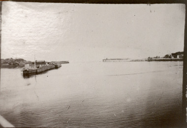
 Lakes Entrance Regional Historical Society (operating as Lakes Entrance History Centre & Museum)
Photograph
Black and white photograph showing piers at entrance from ocean Bass Strait into Gippsland Lakes. Western pier on right shows new concrete extension completed. Eastern pier on left shows machinery and workshed. Strand of barbed wire fencing.boardwalk, restaurant, waterways -
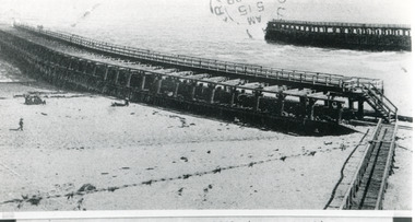
 Lakes Entrance Regional Historical Society (operating as Lakes Entrance History Centre & Museum)
Photograph, 1920c
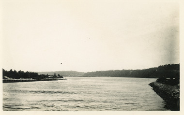
Black and white photograph showing man made entrance from ocean to Gippsland Lakes, north end of western Pier on left, north end of Eastern Pier on right view looking from entrance towards Kalimna. Lakes Entrance Victoriajetties, machinery, waterways -
 Lakes Entrance Regional Historical Society (operating as Lakes Entrance History Centre & Museum)
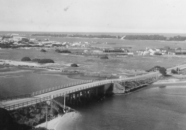
Postcard, Bulmer, H D, 1940c
Black and white postcard of bridge across North Arm, showing post and rail fences on abutments; low tide in North Arm; town buildings and Club Hotel, Cunninghame Arm and sand hummocks with ocean in far distance. Lakes Entrance Victoriabridges, township -
 Federation University Historical Collection
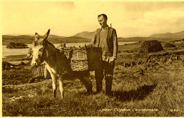
Postcard - black and white, Near Clifden, Connemara, Ireland
Set between the Atlantic Ocean, 12 Ben Mountains and preserved boglands, lies the town of Clifden on the Coast of Connemara.A man stands beside a donkey carry two baskets. It is possibly on the Derrygimlagh Bogchatham-holmes family collection, clifden, derrygimlagh, bog -
 Whitehorse Historical Society Inc.
Map - Atlas
Hand drawn maps of Europe, United States, North Pacific Ocean, Great Britain, China, Iberia Peninsular.Hand-made atlas in an exercise book. Book is covered by Brown paper.E. J. Harris VIII grade Princess Hill. -
 Rutherglen Historical Society
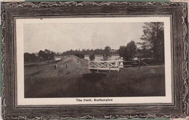
Image, 1900s
Black and white photo shows the weir and Lake King in the Rutherglen Park. The colour photograph is of an ocean liner, the Osterley.Two postcards pasted onto either side of a piece of green cardboard, probably cut from an album. One photo is a black and white photograph. One is in colour.At bottom of black and white photograph: "The Park, Rutherglen" On the top left corner of the colour photograph: "R.M.S. Osterley | 12 129 tons, 14 000 H. Power" rutherglen park, lake king, rms osterley -
 Lakes Entrance Regional Historical Society (operating as Lakes Entrance History Centre & Museum)
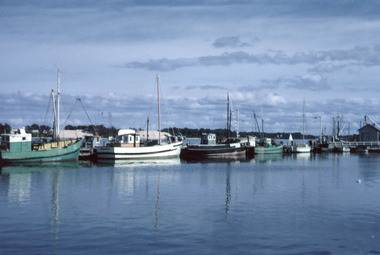
Photograph, Scarce, Keith, 1975 c
Second photograph closer view. 'Kiangah' built of spotted gum by Bulls Shipyard, Metung for Harry RoseColour photograph of fishing boats at Eastern Wharf. Kiangah in centre of image. Lakes Entrance Victoriaislands, ocean, fishing industry, waterways -
 Lakes Entrance Regional Historical Society (operating as Lakes Entrance History Centre & Museum)
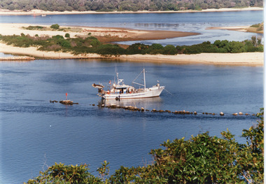
Photograph, Tambo Shire, 1990c
Second copyColour photograph of the south eastern shore of Rigby Island, Gippsland Lakes. It shows the scrub covered hummocks in the background, Hopetoun Channel, dumped sand which connects Snake Island and Rigby Islands, groynes into Narrows from Rigby Island. Fishing boat with scallop dredge moored in sheltered bay inside a groyne. Lakes Entrance Victoriaocean, waterways, topography, fishing industry -
 Lakes Entrance Regional Historical Society (operating as Lakes Entrance History Centre & Museum)
Photograph, Fraser, Nancy, 1983c
from Nan Fraser's albumColour photograph showing new jetty under construction at New Works area, Lakes Entrance, Victoria.vegetation, boats and boating, jetties, ocean -
 Lakes Entrance Regional Historical Society (operating as Lakes Entrance History Centre & Museum)
Photograph, Goff, Russell, 1986c
Black and white photograph of the entrance and Bullock Island showing the western end of Bullock Island formed by successive dumping of dredged sand. Lakes Entrance Victoriajetties, ocean, waterways, public works -
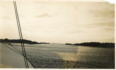
 Lakes Entrance Regional Historical Society (operating as Lakes Entrance History Centre & Museum)
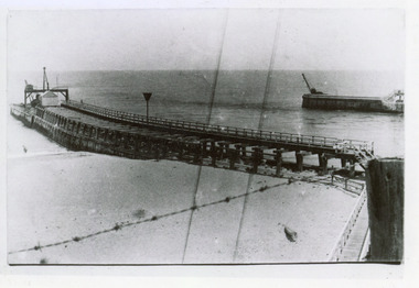
Photograph, 1890c
One other copy same sizeBlack and white photograph of newly opened entrance to Gippsland Lakes from Bass Strait, Lakes Entrance, Victoria.boats and boating, boardwalk, ocean, public works -
 Lakes Entrance Regional Historical Society (operating as Lakes Entrance History Centre & Museum)
Photograph, 1905c
Note on back - Dear Aggie, Met mother Friday evening, train arrived in Melbourne between 6 & 7. Jessie.Colour photograph showing early view of new wooden piers, a few people on pier and on beach. Strand of barbed wire across foreground. Lakes Entrance VictoriaCunninghame, Victoriaboardwalk, jetties, ocean, public works -
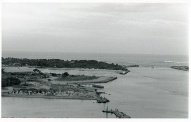
 Lakes Entrance Regional Historical Society (operating as Lakes Entrance History Centre & Museum)
Photograph, 1920c
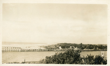
Black and white photograph showing long range view of entrance, piers and dunes from a boat in the main channel, at Lakes Entrance, Victoria.boardwalk, jetties, ocean, ships and shipping -
 Lakes Entrance Regional Historical Society (operating as Lakes Entrance History Centre & Museum)
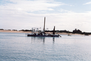
Photograph, 1995c
May be contract dredge Melbourne built by Birdon, Port MacquarieColour photograph of a contract dredge working off Rigby Island, Gippsland Lakes, Lakes Entrance, Victoria.islands, ships and shipping, dredging, ocean