Showing 4282 items
matching point%20gellibrand
-
 Tatura Irrigation & Wartime Camps Museum
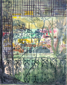
Painting - Painting - Watercolour, Macleahy St. Potts Point, Sydney
Done by Leonhard Adam. Macleahy Street, Potts Point, Sydney NSW. 25 - 26 xi 1949leonhard adam, macleahy street potts point sydney nsw -
 City of Ballarat
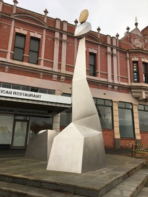
Sculpture - Public Artwork, Akio Makigawa, Point to Sky by Akio Makigawa, 1999
Point to Sky is one of Akio Makigawa’s final works, the commission was completed posthumously. It is the only public artwork by the celebrated Australian-Japanese sculptor of this scale located in regional Victoria. You will see two stainless steel forms, a smaller more rectangle form and the towering geometric form, with seed pod shapes at the peak. These forms represent the house, the artist is expressing that home is a shelter and also a place for gathering. The house form grows into a tower to symbolise the achievements of mankind and the action taken to protect the rights of the community during the Eureka Stockade. The top seed pod is gold, referencing Ballarat as the centre of the gold rush in Victoria, as well as representing the sun as the source of life. The paving of the forecourt was designed in bluestone, typical of the work of Makigawa. Stainless steel panelling and shaping on armature. Set into raised platform of bluestone pavers.Point to Sky, 1999 / Akio Makigawa (1948-1999)/ stainless steel/ Born in Japan, Akio Makigawa arrived in Australia in 1974. He worked as a sail maker in Perth before studying sculpture at the Claremont School of Art and WAIT (now known as Curtin University). He moved to Melbourne in 1981 to do post graduate studies in sculpture at the Victorian College of the Arts and set up his studio. From 1984 he was involved in many public commissions in Victoria and interstate and Japan. / Commissioned by the Victorian Government and the City of Ballarat in 1999. point to sky, akio makigawa, modern, australian sculpture -
 Mission to Seafarers Victoria
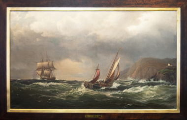
Painting, Madeline M.Ravenna Lewellin, Start Point Light, Devonshire, 1875
This painting was inspired by an original painting by Wilhelm Melby held at the National Gallery of Victoria. Melby is a Danish artist (1824-1882). It depicts a famous Devonshire coastal region famous now for its lighthouse and the pick up point for the pilot when entering waters approaching Dartmouth. The sailing vessels pre-date the construction of the famous lighthouse. Over the centuries the view would have been familiar to many sailors as they left or approached the English mainland and south coast ports in the English Channel. Madeline Mary Ravenna Lewellin (1854 – 24 November 1944) was born in Victoria to Dr John Henry Hill Lewellin, a physician, and Grace Elizabeth (née Danneby). She was one of five daughters, and the family lived in Prahran. Lewellin's brother, Captain Herbert Gordon Hill Lewellin, was a commander in the P. and O. fleet (apprentice on the Romanoff, Lieutenant RNR on the HMS Arethusa in 1899, RMS Mongolia in 1913 sunk in 1917, Naldera in 1920). She studied painting at the National Gallery School in 1879 under Eugene von Guerard. She's also known for collecting and painting specimens, and became a member of the Field Naturalists Club of Victoria in 1885. In 1884 she won a silver medal for her studies of fungi. She collected plants for Australian botanist Ferdinand von Mueller, and the variety of Dicrastylis lewellinii (Purple sand-sage) is named after her. Miss Lewellin, who had a love of the sea and ships as subject matter is listed in 1910 as a donor as a 10/6 member donating to the motor launch fund and in 1918 as a working member of the Ladies Harbour Lights Guild which involved regular volunteer shifts at the Mission to Seamen on canteen and other duties.The donor of this highly regarded painting at the Mission , Miss Madeline R. Lewellin (1854-1944), the artist of this version was actively painting in Victoria between 1877 and 1910, was a silver medallist for studies of fungi. She liaised with Von Mueller and studied under Eugene Von Guerard at the National Gallery, School of Painting in 1879. Her works are represented in the State Library Victoria and a silver medal awarded in 1884 is held by Museum Victoria. This painting represents a tangible link with one of the ladies who interfaced with the seafarers. She had a connection with the sea thanks to her brother, Captain Herbert Gordon Hill Lewellin, who was a commander of the RMS Mongolia during WWI, and became the commodore of the P.&O. Fleet.This oil painting has a dark polished wood and gold leaf slip. The painting depicts two masted boats. The choppy sea takes up the lower-third of the painting, and the other two-thirds of the image of made up of stormy grey clouds. A rocky cliff face can be seen on the right-hand side of the painting. A small church can be seen on the hillside. The ship on the left third of the painting sits on the horizon line of the sea. The centre ship with two masts appears to be leaning to the right and its deck is exposed to the viewer showing four men attempting to handle the masts and rigging. The left-hand ship with three masts is surrounded by two grey distant silhouetted mast ships. There are three seagulls at the upper left-centre of the image. There are another three gulls down on the lower-left of the image. Front: ENGRAVED PLAQUE: Start Point Light. Devonshire. SIGNATURE: After W. Melby / M.M.R Lewellin. 1875. Reverse: IN BLACK MARKER PEN: * Hang from two points * WHITE STICKER WITH CONSERVATOR DETAILS: Art Conservation Frames / 118 Bridport Street, Albert Park, VIC, 3206 / 9696 9066 / artconservationframers.com.aupainting, ships, mast, church, sea, storm, oil painting, seagulls, madeline r. lewellin, artwork-paintings, ngv, wilhelm melby, eugene von guerard, botanist, rms mongolia, captain herbert gordon hill lewellin (1862-1935), paddy lewellin -
 Lakes Entrance Regional Historical Society (operating as Lakes Entrance History Centre & Museum)
Photograph, M Holding, 1/11/1989 12:00:00 AM
Colour photograph of Mitchell River and low bank approaching Eagle Point Victoriajetties, waterways -
 Greensborough Historical Society
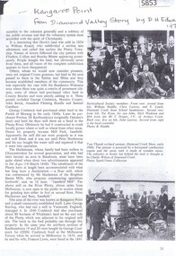
Article, Book, Shire of Diamond Valley, Kangaroo Point, excerpt from Diamond Valley Story, 1979_
References to "Kangaroo Point" taken from The Diamond Valley Story by Dianne H. Edwards, pages 31-32, 97, 109. 4 photocopied pages. kangaroo point -
 Federation University Historical Collection
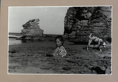
Photograph - Photograph - Black and White, Point Lonsdale, Victoria; Back Beach below the Lighthouse - Girl with a Dog
Work produced during Paul Lambeth's photography class The photograph shows the back beach at Point Lonsdale, below the Point Lonsdale Lighthouse. This area was where many sailing ship coming to Melbourne were wrecked. This was due to the narrow passage through The Rip and the tides at certain times. A Pilot Station was established and ship captains could signal for a Pilot to steer them through The Rip and into Port Philip Bay. Black and white photograph adhered to a beige coloured mount card showing a girl down a hole in the sand with her dalmation dog sitting in a rock pool.paul lambeth, point lonsdale, back beach, sailing ships, ship wrecks, the rip, port philip bay, pilot station, girl, dalmation dog -
Whitehorse Historical Society Inc.
Document, Round Point Peg Co.Pty.Ltd, 1/10/1960 12:00:00 AM
A letter of reference for Frederick Alfred Cottle from the Managing Director of the Round Point Peg Co. Pty. Ltd.A letter of reference for Frederick Alfred Cottle from the Managing Director of the Round Point Peg Co. Pty. Ltd. Frederick, who was the grandfather of Rachael Cottle, lived 1920 - 1993 and moved to 51 Milton Street, Nunawading. A letter of reference for Frederick Alfred Cottle from the Managing Director of the Round Point Peg Co. Pty. Ltd. cottle, frederick alfred -
 Phillip Island and District Historical Society Inc.
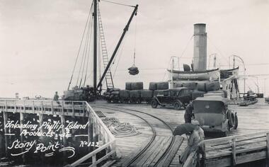
Photograph
One of a collection of over 400 photographs in an album commenced in 1960 and presented to the Phillip Island & Westernport Historical Society by the Shire of Phillip IslandPhotograph looking down the Stony Point Jetty with the S.S."Killara" being unloaded by Derrick.local history, photography, photographs, maritime technology, cargo handling, stony point jetty with s, "killara" background, shipping, steam ships, ss killara, stony point, phillip island produce, john jenner, bryant west -
![Cumberland Creek, near Point Sturt / [by] Nicholas Caire, circa 1876](/media/collectors/550653872162f11fb04854aa/items/57834713d0cdd1176c71111b/item-media/57834799d0cdd1176c71e113/item-fit-380x285.jpg) Kew Historical Society Inc
Kew Historical Society IncPhotograph, Anglo-Australasian Photographic Company, Cumberland Creek, near Point Sturt, c. 1876
Nicholas Caire was born on Guernsey in the Channel Islands in 1837. He arrived in Adelaide with his parents in about 1860. In 1867, following photographic journeys in Gippsland, he opened a studio in Adelaide. From 1870 to 1876 he lived and worked in Talbot in Central Victoria. In 1876 he purchased T. F. Chuck's studios in the Royal Arcade Melbourne. In 1885, following the introduction of dry plate photography, he began a series of landscape series, which were commercially successful. As a photographer, he travelled extensively through Victoria, photographing places few of his contemporaries had previously seen. He died in 1918. Reference: Jack Cato, 'Caire, Nicholas John (1837–1918)', Australian Dictionary of Biography.An original, rare photograph from the series 'Views of Victoria: General Series' by the photographer, Nicholas Caire (1837-1918). The 60 photographs that comprise the series were issued c. 1876 and reinforced a neo-Romantic view of the Australian landscape to which a growing nationalist movement would respond. Nicholas Caire was active as a photographer in Australia from 1858 until his death in 1918. His vision of the Australian bush and pioneer life had a counterpart in the works of Henry Lawson and other nationalist poets, authors and painters.‘Cumberland Creek, near Point Sturt’ : Views of Victoria (General Series) No.59 : Albumen silver photograph | Photo on card with Title and Description on reverse | Mounted 24 x 30 cm; Photo 12 x 17 cm.On Reverse: ‘The Cumberland Creek is so named from the close resemblance it bears to the place bearing that name in the mother country. The present illustration represents the precipices and hills which surround the Cumberland Creek. The soil around the hills is mostly sandstone rubble, hence the only vegetation identical with the spot is the inevitable sword grass and salt scrub, which frequently exist where no other vegetation can be found.’nicholas caire (1837-1918), landscape photography -
 National Vietnam Veterans Museum (NVVM)
Model - Diorama, LUP Lying Up Point
Depicts lying up point at last light of a five man SAS patrol. All members are lying in a circle with heads inner most at touching distance from each other to warn of snoring or enemy. Backpacks are handy, belts are used as pillows.diorama, lup -
 Lorne Historical Society
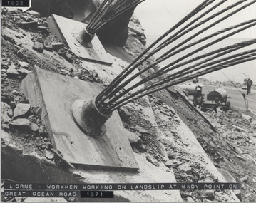
Photograph, Great Ocean Road. Windy point land slip
1971. This was some of the machinery used in stabilsing the Great Ocean Road between the St George's River and the Sheok River. Holes were drilled in the rock and large cables inserted and concrete forced in around themGreat Ocean Road. This was some of the machinery used in stabilizing the G.O.R. at Windy Point, between the St George River and the Sheoak River. Holes were drilled in the rock and large cables inserted and concrete fixed around them. This took place in late 1971great ocean road. g.o.r. landslip. windy point. 1971 -
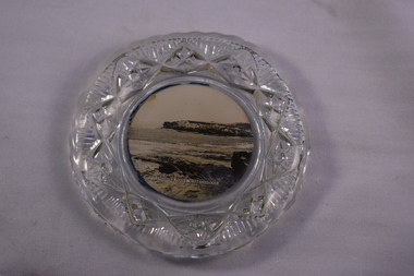 Warrnambool and District Historical Society Inc.
Household, Souvenir Plate, 1920s
This souvenir plate was sold to tourists in Warrnambool in the 20th century. It features an image of a popular tourist spot off the coast of Warrnambool – Thunder Point. Tourism has always been an important industry in Warrnambool and souvenir items such as this one continue to be sold, although colour images would most likely be used now. This plate is of interest as an example of items sold to local tourists in the 20th century. It will be useful for display. This is a circular glass plate with a ripple pattern on the rim and an outer edge with the glass heavily-impressed and patterned. The base of the plate has a sepia-coloured image of Thunder Point, Warrnambool. The image has been taken from a photograph. This has been affixed to the back of the plate and has a dark blue backing. ‘Thunder Point Warrnambool’ tourism in warrnambool -
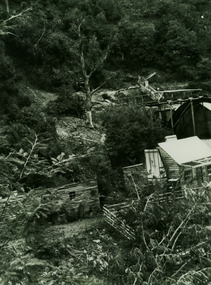 Marysville & District Historical Society
Photograph (item) - Black and white photograph, Unknown
A black and white photograph of a gold mine, purported to be between Wood's Point and Jamieson.A black and white photograph of a gold mine, purported to be between Wood's Point and Jamieson.One of the mines (I think we passed this between/ Wood's Point and Jamieson)/ (photo given by Ken Morrison?)gold mine, wood's point, jamieson, gold sluice, photograph -
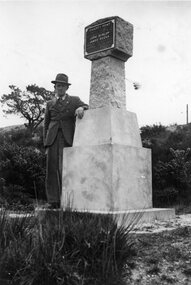 Ballarat Tramway Museum
Photograph - Black & White Photograph/s, Wal Jack, Wal Jack at Poverty Point Monument, Sept. 1946
Photo of a man (Wal Jack) standing by the Gold Monument at Poverty Point at the rear of Main Street Ballarat East. Monument looks new or recently cleaned up. Photo taken Sept. 1946.Has a close association with Wal Jack, an avid collector of Ballarat Tramway and other tramway and railway materials.Black and white photographic print.On rear in ink "Gold Monument at rear of Main Street Ballarat East. / First gold discovered in Ballarat 1851 / Sept 1946." In Wal Jack's handwriting.trams, tramways, ballarat, gold monument, poverty point -
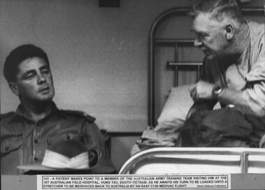 National Vietnam Veterans Museum (NVVM)
Photograph, Making a Point
A black and white photograph of a patient makes a point to a member of the AATTV visiting him at the 1st Australian Field Hospital, Vung Tau, South Vietnam, as he awaits his turn to be loaded onto a stretcher to be medivaced back to Australian by an RAAF C130 Medivac flight.photograph, aattv, 1st australian field hospital, vung tau, raaf, medivac, c130 medivac flight, gibbons collection catalogue -
Lakes Entrance Regional Historical Society (operating as Lakes Entrance History Centre & Museum)
Photograph, 1957
Photograph taken with olde Brownie Box camera January 1957.Black and white photograph of Mitchell River silt jetties taken from cliff at Eagle Point Victoriawaterways -
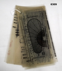 Bendigo Military Museum
Equipment - Font -Type Style and Point Size Guide, Royal Australian Survey Corps, Circa 1991
Also referenced in the Collections Victoria Bendigo RSL item 6300 Lithographic Squadron Equipment Handbook 1991. Commonly called a type styles guide, used for the selection and editing of text styles and size in mapping.20 Sheets of 21 x 11 cm clear photographic film (connected in the Top left hand corner) depicting various Type Font Styles and Point Sizes including special characters. It also contains a digital Type gauge, a linometer and a screen angle Indicator. royal australian survey corps, rasvy, fortuna, army survey regiment, army svy regt, asr -
Glenelg Shire Council Cultural Collection
Drawing - Sketch, MELISSA BOAG, Gannets at Point Danger, 2015
Four pen and wash sketches - Gannets at Point Danger. Sketches mounted one beneath the other. Sketches have a white background, black ink, several different colour washes, double white mat board, blonde wooden frame, reflective glass, wire hanger on backFront: Each image is signed 'M. Boag July 2015'. black ink, lower right corner -
Lakes Entrance Regional Historical Society (operating as Lakes Entrance History Centre & Museum)
Photograph, 1996
Also another photogaphs taken of same trip at Batty Golebys Fete garden Mt Cotton 05334.1 10 x 15 cmColour photograph of three women Esme Dunlop nee Lind and Nan Fraser on trips to Victoria Point Queenslandpeople -
 Greensborough Historical Society
Map, Melbourne and Metropolitan Board of Works. Survey Division, MMBW, Yarra 2500 / 12.23. Janefield and Kangaroo Point, 1977_10
Melbourne and Metropolitan Board of Works. Yarra 2500 [base map] 12-23, Municipalities of Whittlesea 239 and Diamond Valley 257. No streets marked on this map. Includes Plenty River, Kangaroo Point, Janefield Colony and Janefield Reserve.MMBW Map in 1:2500 [scale] series. Cream parchment with green tape reinforcing on edges and punched holes on left edge.mmbw, melbourne and metropolitan board of works, shire of diamond valley, plenty - maps -
 Whitehorse Historical Society Inc.
Photograph, Church of Christ Anglican Church, Mitcham, C1948
Black and white photograph of a camp held by the Church of Christ Anglican Church at Toc H campsite at Point Lonsdale C1948christ church anglican church, mitcham -
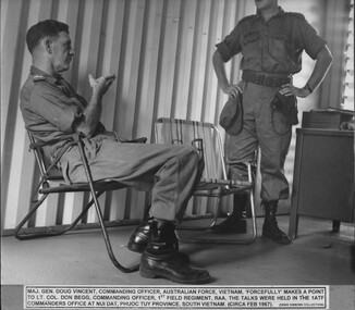 National Vietnam Veterans Museum (NVVM)
Photograph, Making A Point
A black and white photograph of Maj Gen Doug Vincent Commanding Officer, Australian Force Vietnam "forcefully" makes a point to Lt Col Don Begg, Commanding Officerm 1st Field Regt RAA. The talks were held in the Ist ATFCommanders office at Nui Dat, Phuoc Tuy Province, South Vietnam (circa Feb 1967)photograph, maj gen doug vincent, lt col don begg, raa, 1st field regt, 1st atf base, nui dat, phuoc tuy province, gibbons collection catalogue -
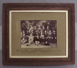 National Wool Museum
Photograph
Photo depicts the Committee who organised the First Annual Picnic of the Employes of the Wool brokers Association Stores held at Schnapper Point, 23 March 1896Committee - First Annual Picnic of the Employes of the Wool brokers Association Stores held at Schnapper Point, 23 March 1896Committee - First Annual Picnic of the Employes of the Wool brokers Association Stores held at Schnapper Point, 23 March 1896wool stores - staff, woolbrokers association stores -
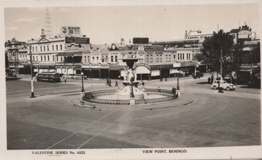 Ballarat Tramway Museum
Postcard, Valentine & Sons Publishing Co, "View Point Bendigo", c1940
Printed black and white postcard of View Point overlooking the Alexandra Fountain, Charing Cross Bendigo. In the view is an SEC tram, along with R O Henderson The Beehive, A E Sayer Chemist, J B Edwards Watchmaker, Metthews Bros Mens and Boyswear, and Wrights Stores. Published by Valentine of Melbourne and Sydney.Yields information about Bendigo's Charing Cross and View St c1940Postcard black and white, unused - Valentines series No. 4222.tramways, trams, bendigo, charing cross, view point -
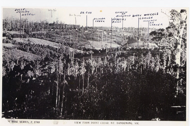 Mt Dandenong & District Historical Society Inc.
Photograph, View from Point Clear, Mt Dandenong, Vic
Rose Series Postcard number 2783Copy of Rose Series postcard #2783 showing view from Point Clear. This is taken from Ridge Road. The following indicators have been marked on the photograph L-R Dulce Domun Hotel, White's, Rev. Davies, Dr. Cox, Olinda Creek, Dickens Road, Church of England, Buggy Wheels Corner, Monash Ave. Corner.mount dandenong, ridge road, rose series, point clear -
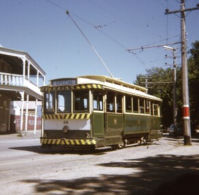 Ballarat Tramway Museum
Slide - 27 mm sq slide/s - set of 5, Andrew Howlett, Tram 26 on private tour - View Point line, Mar. 1969
Yields information about a special tram service during March 1969 and some unusual moves.Set of four Colour slides, Kodak white cardboard mount, developed March 1969 of a special tram that apparently ran from the depot via View Point, shunted at Ripon St and again at Hospital corner. ..1 - No. 26 running a special in Wendouree Parade, View Point, with the Lake View Hotel. .2 - ditto - and a catering company in the view, as well as a Telephone box. .3 - running from Ripon St into Sturt St. .4 - shunting at Hospital corner - then possibly crossed 34 at Parker St Loop - see 7668. .5 - ditto, but before .4, with the tram rounding the corner from the North side of Sturt St into Drummond St. It would then appear that the tram then reversed a bit before going back into Sturt St onto the South side. One of a series of tour photos - see Reg item 7667, 7668, 7683 and 7701.ballarat, tramways, trams, view point, wendouree parade, ripon st, hospital corner, sturt st, tours, tram 26 -
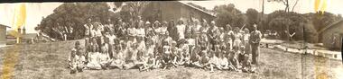
Federation University Historical Collection
Photograph, Ballarat Teachers' College Students at Ricketts Point, 1949, 1949
Black and white photographs of Ballarat Teachers' College Students at Ricketts Point, 1949. .1) L-R Merle Williams, Marg Ransome, Mary Bilton, Shirley Down, Helen Veitch, Rita Rowland, Barbara Young. 2.) L-R Helen Veitch, Marg Ransome, Mary Bilton, Lois Cheetham, Shirley Dawn, Mr Burns, Rita Rawland, Barbara Younghelen veitch, marg ransome, mary bilton, lois cheetham, shirley dawn, mr burns, rita rawland, barbara young, ballarat teachers' college, ricketts point, merle williams, shirley down, rita rowland -
 Orbost & District Historical Society
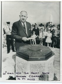
black and white photograph, April 20 1970
Sir Henry Bolte, premier of Victoria, renamed Cape Everard at Point Hicks during the Centenary of Cook's Landings on April 20, 1970. There is no land feature at Cook's coordinates of 38°0'S and 148°53'E, a point which lies several miles out to sea and under 50 fathoms of water. Captain Cook invented Point Hicks so that he could conceal Bass Strait and the insularity of Tasmania. The Admiralty had issued its usual instructions to hide strategically important discoveries that could become security risks. Captain Hicks was James Cook`s senior lieutenant. There has been some dispute as to whether Zachary Hicks actually saw Point Hicks or whether he saw Ram Head about 20 kilometres further up the coast. Although Cook named the promontory Point Hicks it was changed to Cape Everard in 1843.. In 1970 the Victorian government changed the name Cape Everard to 'Point Hicks'. It lies on dry land, about 22 nautical miles (41 km) northeast of Cook's phantom Point Hicks, where it preserves the story of Cook's first landfall in Australia. This is a contemporary pictorial record of a significant event in East Gippsland's history.A black / white photograph of a man in a suit making a speech with the audience standing behind him. He is standing in front of an octagonal-shaped directional marker set ointo a stone support. There is a policeman behind him. In the background to the right is a lighthouse.on front - "20th April 1970, Sir Henry Bolte renames C. Everard as Pt Hicks" handwritten in block letterscook-james-point-hicks cape-everard bolte-henry -
Lakes Entrance Regional Historical Society (operating as Lakes Entrance History Centre & Museum)
Book, Nelson, Ivar; Miller, Patrick; Sawyer, Terry, Trip to Croajingalong 1889, 1991
Results of conservation recording exercise undertaken at Point Hicks, plus previous studies, prior to de-staffing the lighthouse in readiness for either sale or lease to an appropriate body.lighthouses, coast -
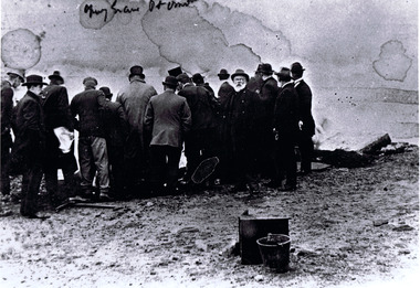 St Kilda Historical Society
Photograph, Exhumation of Glen Huntly Pioneers, 27/08/ 1898
Exhumation of Glen Huntly Pioneers at Point Ormond black and white photograph copy(?) grave Pt Ormond