Showing 24911 items
matching ocean
-
 Warrnambool and District Historical Society Inc.
Booklet - Booklet Collection: City of Warrnambool Tourist Guides, Collett, Bain and Gaspar, Warrnambool
This is a collection of sixteen tourist guides dating from the mid 1970's to 2013. These contain listings of businesses, accommodation, eateries and events in Warrnambool and district. They also include maps of Warrnambool and surrounds, advertising and photographs of various attractions. While mainly covering Warrnambool a small number of the guides cover the South West Region. These directories have mainly been published by the Warrnambool City Council and are a selection of the types of information provided to visitors at the Tourist information centre during this time period.These tourist guides give snapshots of the City of Warrnambool for the years covered and will be useful for research.[.1] An 8 page paper booklet with black printing and a black & white photo of the pond at the Botanical Gardens on the front cover. [.2] two photocopied A4 black and white pages from the book "On the Trail" K Winser 1956 (Main Roads of Australia) [.3] A trifold colour brochure with a stylised map of the coast on the yellow and blue front cover. The inside has stylised colour drawings on Warrnambool attractions. The rear cover has coloured photographs of bush, Liebig Street and Fletcher Jones gardens [.4] A trifold black and white brochure with a black line drawing of a whale on the front cover. [.5] A trifold white card with mauve printing. The front cover has a line drawing of the former Timor Street post office and a map of businesses and landmarks in Timor Street. The reverse side contains a brief history of Warrnambool. [.6] A 98 page stapled booklet with a foreword by Vanda Savill. There are 4 pages of coloured photographs. The remainder are black and white photographs. The front cover is purple with white writing in the lower third. There is an outline of the coast and five colour photographs of district attractions. The inside middle page has a map of the Western wonderland region. The content covers towns in this area. Content relating to Warrnambool is in the last six pages. [.7] Twelve loose photocopied black and white pages. The front cover has the Warrnambool Premier Town 1988-1991 logo and a photo of a Southern Right Whale and calf. The bottom right hand corner has a Standard Warrnambool logo. [.8] 44 page booklet printed with blue ink. The staples have been removed. The glossy front cover has blue printing with a coloured photo of Flagstaff Hill Maritime Village pond. The centre pages has a fold out map of the City of Warrnambool. The rear cover has photos of The Twelve Apostles and Hopkins Falls. [.9] 4 loose photocopied pages with Warrnambool Library and Corangamite Regional Library Service Warrnambool City Library black ink stamps. The front page line drawing illustrations of Warrnambool attractions [.10] A single sheet of glossy white paper folded in half to make four pages. The front page has a Warrnambool premier town logo 1979-1982 and blue printing and a visitor survey. [.11] A conference pack of light card folded to make a pocket containing three brochures, a shipwreck coast tourist directory and a Australian Heritage Parks Association conference program dated 24 to 27 May 1992. The front cover of the pack has green writing over a stylised upward arrow. There is a City of Warrnambool logo in the top right hand corner and two film strips diagonally across the cover containing photographs of Warrnambool. The rear cover has a coloured Warrnambool Premier Town logo. [.12] A 63 page stapled booklet with coloured photographs of Warrnambool. The front cover has black writing on white background. There is a coloured photograph of Flagstaff Hill in the middle of the cover and a Warrnambool City and Visit Victoria logos on the lower edge. The middle pages has a coloured of the city of Warrnambool with an inset map of Allansford. [.13] A single large sheet of white paper folded in ten to make a brochure. The front cover has black printing. The rear cover has a purple ink stamp for the City of Warrnambool Tourist Information Centre. When folded out the reverse side has a green, grey and white map of the South West Region of Victoria. [.14] A 48 page colour booklet on glossy paper. The front cover has white writing on a blue background and includes photographs of the Twelve Apostles, the Promenade walk, Flagstaff Hill and a southern right whale's tail. The rear cover has photographs of The Twelve apostles, a passenger train from Melbourne passing the Lake Pertobe playground, and a rural scene. There is white writing and a white Warrnambool City logo on a blue background. The centre pages have a stylised green and blue map of the city of Warrnambool. [.15] A 48 page colour booklet on glossy paper. The front cover has white writing over colour photographs of two people at a lookout, Flagstaff Hill, three southern right whales and a child at the Lake Pertobe playground. The lower edge has blue upper case writing on a white background. The rear cover has a colour photograph of the Twelve Apostles. The lower white border on the rear covers has a a blue and green City of Warrnambool logo and blue writing. The centre pages have a stylised green and blue map of the city of Warrnambool. [.16] A 64 page colour booklet on glossy paper. The front cover has black writing on a black background and there is a photograph of a southern right whale's tail. The lower edge has the Warrnambool City and Visit Victoria Logos. The centre pages have maps of Warrnambool and surrounds. [.1] This week in Warrnambool Vol 2 No. 5 Thurs 1st Feb. For the time of your life [.2] Warrnambool Way [.3] Warrnambool The Holiday Host on the South West Coast with compliments City of Warrnambool and Warrnambool Chamber of Commerce [.4] MMI Insurance presents Whales Giants of the Deep Whale Watcher's Logbook Warrnambool [.5] Warrnambool History began in Timor Street [.6] Western Wonderland Tourist Association [.7] A Premier Arrow Tour of Warrnambool Victoria's Premier Town Australia's Southern Right Whale Nursery [.8] Warrnambool The Heart of Victoria's Great Southwest Visitor's Handbook [.9] What to see in Warrnambool Victoria's Premier City 1979-1982 [.10] Win a Free Holiday & $200 Cash in Victoria's Premier Town [.11] Advancing Warrnambool together! [.12] Great Ocean Road Warrnambool Official Visitor Guide [.13] Tourist guide to the South West Region Victoria All it needs is you [.14] Warrnambool visitor guide 2005 the great ocean road experience attractions accommodation entertainment dining [.15] Warrnambool Visitor Guide 2006 the great ocean road experience Attractions Accommodation Entertainment Dining [.16] Official Visitors' Guide Warrnambool Victoria Australia Discover the Great Ocean Road warrnambool, warrnambool tourist guides -
 Federation University Historical Collection
Document, Ken Clements, Peterborough Puzzles, 2009, 2009
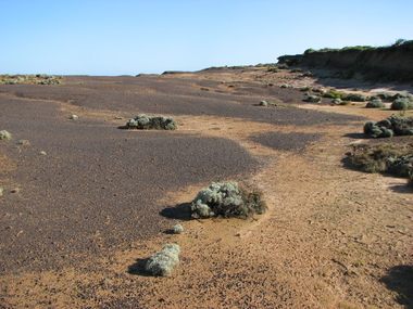
Massacre Bay is located on Victoria's Great Ocean Road, and is in the centre of the Bay of Martyrs. The bay consists of 20 m high, red limestone bluffs. This paper by Ken Clements considers the origin of the term martyr in connection to this location, and where the Aboriginal massacre may have taken place. Thirteen page document by Ken Clements relating to Peterborough, Victoria. Contents include coastal features, local Aborigines, Bay of Martyrs, Massacre Bay, Massacre Hill, Buckley Creek Run, Pioneer Pastoralists, British Traversers, settlers, Peterborough, Maps, tourism, history method. Photographs by Laurie Moore.aborigines, bay of martyrs, massacre bay, massacre hill, buckley creek run, pioneer pastoralists, british traversers, settlers, peterborough, maps, tourism, history method, childers cove, barque children, murnane bay, sandy bay, dog trap bay, buckley creek, viviennes lookeout, stanhope bay, buttres bay, burnies beach, armstrong creek, flaxman hill, antares rock, lovers nook, crofts bay, clements, worm bay, halladale point, the well, wold dog cove, james irvine monument, curdies inlet, squirrel creek, wallaby creek, boggy creek, whiskey creek, pioneer beach, schomberg rock, young australia, spit, crown of thorns, newfield bay, the grotto, london bridge, point hesse, high cliffs, the arch, cape martyr, little massacre bay, aboriginal massacre, ken clements -
 Melton City Libraries
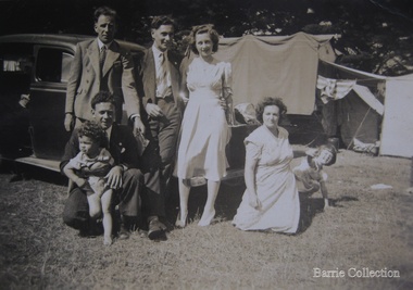
Photograph, Edna and Bon's family camp trip at Apollo Bay, 1948
Wendy Barrie's memories of Apollo Bay The camping trips were a yearly event after the harvest had finished. The trip down to the beach was a much-anticipated event heading out through Parwan and to Geelong leaving behind the hot and dusty plains and our parents relieved to have the hard work of harvesting left behind. The Otways in the distance were reached with great anticipation, Mum in the car and Dad in the Truck ahead of us anxiously winding through the narrow roads and negotiating the hairpin bends and breathing in the cool fresh air of the forest, and keeping an eye out of the log trucks that might come sweeping the corner. The tree ferns with their dripping moisture and the giant trees and the unmistakeable small of the eucalypts. Great excitement was when we caught our first view of the sea from the highest point of the road and then is was the cautious drive the sea level to the sight of the blue ocean with the white of the waves crashing on the rocks and the pristine sand. The water from the Wild Dog and Skenes creek trickling onto the ocean. The tree ferns with their dripping moisture and the giant trees and the unmistakeable smell of the eucalypts. The return journey was usually taken on the Great Ocean Road, it was considered safer to be on the inside of the road. In the early days it was very narrow and passing oncoming cars was taken very cautiously. Landslides and floods sometimes meant we would take the inland route. One year the bridges were washed away and bailey bridges were erected to keep the road open. Rock falls off the cliffs were common Stops on the way home gave us our last chance for our feet in the sand and a swim in the ocean. By the time we reached the hill at Angle Sea the vast blue ocean was behind us and we trekked back through Geelong- Bacchus road and the plains of stubble and the dry grass, and sometimes evidence of burnt patches from a bush fire. The closest we came to a pool at home was the concrete sheep trough at the gate to the work sheds. It was filled with bore water pumped from the nearby windmill. Edna, Bon and their family members at their camp site in Apollo Baylocal identities -
 Queenscliffe Maritime Museum
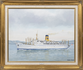
Painting - Mariposa, Dacre Smyth, SS Mariposa
SS Mariposa was a luxury ocean liner launched in 1931, one of four ships in the Matson Lines "White Fleet", which included SS Monterey, SS Malolo, and SS Lurline. She was later renamed SS Homeric. Mariposa was designed for service in the Pacific Ocean, including regular stops in ports along the West Coast of the United States, Hawaii, Samoa, Fiji, New Zealand, and Australia. On the 12th January 1942 the Mariposa left San Francisco in the "Australian — Suva" convoy escorted by two destroyers and the light cruiser and with two other troopships (destined for Suva). This was the first large convoy to Australia after Pearl Harbor with Mariposa transporting Army personnel, ammunition and fifty P-40 fighters intended for the Philippines and Java.Mrs B SmythAn oil painting of the SS Mariposa in an ornate gold frame. Mariposamigrant ships, ss mariposa, wwii -
 Bendigo Military Museum
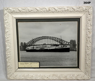
Photograph - PHOTOGRAPH, FRAMED, HMAS MANOORA, Post 1945
Requisitioned by the RAN on 11.10.39 and outfitted as an Armed Merchant Cruiser. Commissioned 12.12.39 and Decommissioned 6.12.47 and refitted back to original use. Battle Honours, Indian Ocean 1941-42, Pacific 1942-45, New Guinea 1944, Leyte Gulf 1944, Lingayen Gulf 1945, Borneo 1945. Framed photo of "H.M.A.S. Manoora" Black and white photo of full length of ship. Sydney Harbour Bridge is in the background. The frame has stylised branch and leaves. Heavily printed over with cream paint.Marked on rear of frame, "L. SCHILLING" On front states HMAS MANOORA, armed merchant cruiser. 1939 - 1945.photography, hmas ran -
 Mission to Seafarers Victoria
Letter - Correspondence, 1/11/46
Letter from Allan Quinn to his mother depicting his time spent on board American ships.This letter is of historical, social and interpretive significance as it provides information about the life of a seaman during the mid 20th century. Two page, double sided letter (0334.A1-A2) written in black ink. Dated 01/11/46 while at sea and envelope (0334.B).Envelope: "Mrs S Quinn/San Lorenzo/63 Ocean Beach/Manly N.S.W/Australia" Top right hand corner of letter: "M. J. Ariston/At Sea/1-11-46" Letter: "My Dear mum, Have now made one round trip..."allan quinn, 1926, america, mission to seafarers -
 Magnet Galleries Melbourne Inc
view on board ships leaving Australia, red cliffs00156.tif
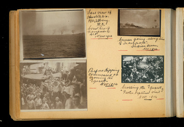
Four photos on a page from an albumLast view of Australia off Albany W.A. coast line of transport of a.i.f. 1st nov 1914 ... going along line of transport indian ocean nov 1914 crossing the equator - " ... neptune visit" nov 1914 Before dipping commenced on crossing the equator nov 1914ww1, world war 1, a.i.f., albany, western australia, 1914, ship, indian ocean, equator -
 Red Cliffs Military Museum
Badge Replica, Commemorative Badge R.S.L, (estimated); 1980-1990
This reproduction of the first R.S.L. Badge is a Limited Edition released as a commemorative badge cira 1980-1990The First R.S.L. Badge/ This specially crafted lapel badge is a/limited edition replica of the very first/ R.S.L. badge which decorated our soldiers/ and sailors returning from WW1/ This badge was worn with Pride from/ 1919-1926 by the founding members of/ the R.S.L., as they Returned Home to a Victorious Australia./ Right side of paper: Oceanic Life is proud to present this commemorative Badge to you, as a small/ token of our continuing commitment to/ the Men and Women who have served/ their country. Reverse Sise left: Symbol of Oceanic Life Ltd./ Right side: The Returned & Services League/ Commemorative Lapel Badge/ Circ 1919-1926badge, r s l, commemorative, circa, 1980 1990 -
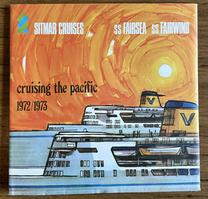 Port Melbourne Historical & Preservation Society
Plan - Ship plans, Melbourne Harbor Trust, 1980s
Ship Plans In 2 boxes labelled "Harbour Trust" .01 Flotta Lauro .02 Sea Princess .03 Shaw Saville - Ocean Monarch- MV Akaroa - Mv Arawa - MV Aranda .04 Chandris - Britanis - Queen Frederica .05 Sitmar - TV Fairsky - SS Fairsea - SS Fairwind - Fairstar .06 SS United States - Marco Polo - Monterey- Mariposamelbourne harbor trust - port of melbourne authority, flotta lauro, sea princess, ocean monarch, shaw savill, p & o, lauro line, britanis, chandris lines, sitmar, fairstar, fairsky, fairwind, marco polo, monterey, mariposa, ss united states, united states line, royal interocan lines, mv tswingi, mv akorda, mv arawa, mv aranda, queen frederica, fairsea, transport - shipping -
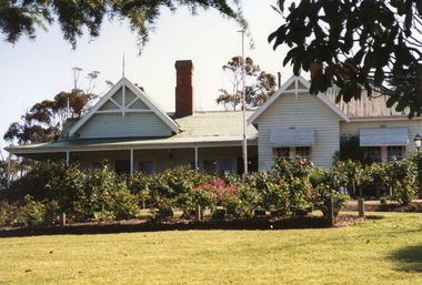 Lakes Entrance Regional Historical Society (operating as Lakes Entrance History Centre & Museum)
Photograph, 1999
Nyerimilang Homestead is in public ownership, managed by Parks Victoria.Colour photograph of Nyerimilang Homestead showing front view, including rose garden. Situated off Kalimna West Road, Nungurner, it is a large white painted timber homestead, corrugated iron roof of hips and gables, painted green, five internal brick chimneys. Situated above the lake with views of Fraser Island and Flannagan Island, outer barrier and distant ocean. Nungurner Victoriawaterways -
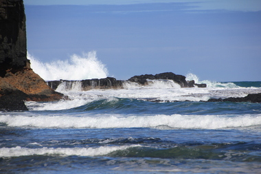 Ballarat Heritage Services
Digital photographs, L.J. Gervasoni, Bushrangers Bay, 2016
coast, coastal, coastal geomorphology, geology, ocean, waves, bushrangers bay -
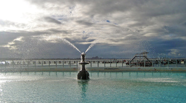 Ballarat Heritage Services
digital photographs, Lisa Gervasoni, Eastern Beach Pre Olypmic Swimming Pool, 2010 - 2017
Colour photograph of the fountain at the Eastern Beach Swimming Pool.swimming, pool, sport, pre olympic, ocean, eastern beach, geelong -
 Ballarat Heritage Services
Digital photograph, Lisa Gervasoni, Cape Bridgewater, c2015
cape bridgewater, geology, ocean, coastal, landscape, seascape, petrified forest -
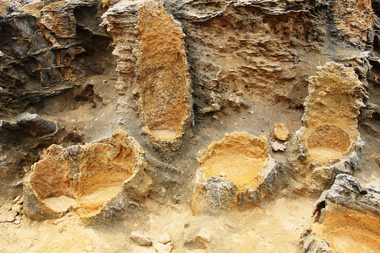 Ballarat Heritage Services
Digital photograph, Lisa Gervasoni, Petrified Forest at Cape Bridgewater, c2015
Colour photograph of the Petrified Forest at Cape Bridgewatercape bridgewater, geology, ocean, coastal, landscape, seascape, petrified forest -
 Ballarat Heritage Services
Digital photograph, Lisa Gervasoni, Cape Bridgewater, c2015
cape bridgewater, geology, ocean, coastal, landscape, seascape, petrified forest -
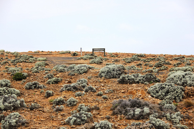 Ballarat Heritage Services
Digital photograph, Lisa Gervasoni, Cape Bridgewater, c2015, c2015
Colour photograph of a landscape at Cape Bridgewater.cape bridgewater, geology, ocean, coastal, landscape, seascape, petrified forest -
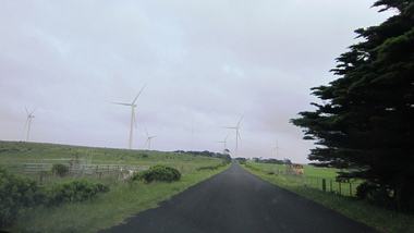 Ballarat Heritage Services
Digital photograph, Lisa Gervasoni, Cape Bridgewater, c2015
cape bridgewater, geology, ocean, coastal, landscape, wind farm, wind turbines -
 Port Fairy Historical Society Museum and Archives
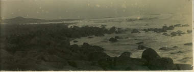
Photograph
Black and white photograph of the sea looking South East showing the island in the background and a rough sea inbetweenbeach, south beach, waves, ocean, island, rocks, reef -
 Port Fairy Historical Society Museum and Archives
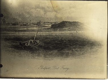
Work on paper - Lithograph, S.T.Gill, Belfast, Port Fairy, 1857
Seascape from original drawing ascribed to S.T. Gill - "Belfast, Port Fairy" published 1857Photograph of etching of seascape drawing of Port Fairy (artistic view) town looking north west from the sea showing town and windmill on the left, a man in a dingy, island in the middle and a sailing ship and Battery Hill on the rightBelfast, Port Fairy - Published by Sands and Kenny Melbourne and Sydney 1857beach, ocean, dingy, windmill, town, sea, ship -
 Port Fairy Historical Society Museum and Archives
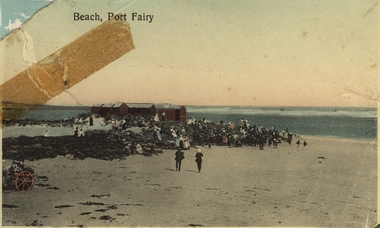
Photograph - Postcard, A.C. Aberline, Beach Port Fairy, 1920
South Beach 1921PhotographAberline Copyright printed in Germanybeach, bathing boxes, south beach, cart, people, ocean, sea -
 Port Fairy Historical Society Museum and Archives
Photograph
East beach near Battery HillColoured photograph of Empty beach with scrub and picket fence in foregroundeast beach, battery hill, ocean, sea, dune, tea tree, tree -
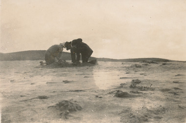 Port Fairy Historical Society Museum and Archives
Photograph
Yambuk beach digging for wormsBlack and white photograph of two people kneeling in the sand digging up sand worms for fishinglooking for worms Yambuk march 1927yambuk, yambuck, beach, worms, fishing, sea, ocean -
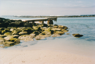 Port Fairy Historical Society Museum and Archives
Photograph
South beach diving boardsouth beach, diving, board, sea, ocean, rocks, reef -
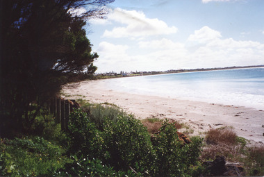
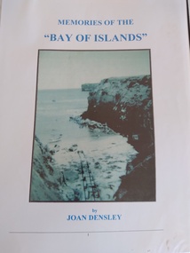 Peterborough History Group
Book, Memories of the Bay of Islands + Crofts Bay Huts
Early use of Crown Land for holiday makers prior to the Great Ocean Road extension, when leaseholders were forced to relinquish their land and houses. Includes a list of the names of occupants at that time. Also includes letters from the Crown Lands Dept about the efforts to retain the Crofts Bay Huts.Significant because it is an eyewitness description of the huts which were demolished in the mid 1970's. Also describes holiday activities and mentions other families in the area.Folder containing the photocopy of the book by Joan Densley and the separate story of the Crofts Bay huts.including copies of Crown Land documents and letters. Includes copy of photographs of the huts and beach.peterborough, crofts bay, bay of islands, joan densley, great ocean road, crofts bay huts, bay of islands huts -
Lakes Entrance Regional Historical Society (operating as Lakes Entrance History Centre & Museum)
Photograph, Lakes Entrance Tidy Town Committee, 2000 c
Also three other colour photographs taken the same day of vegetation on dunes between ocean and golf club greens 04279.1 04279.2, 04279.3 which shows view across Warm Holes to Golf Club No 1 green adjacent to Eastern Beah all 10 x 115 cmColour photograph showing Brian Klemm of Keep Australia Beautiful Council with Margaret Daly and Trish Haberfield of Tidy Town Committee with John Stapleton Robert Blackham Tony McDonough Barry McKenzie and Trevor McCubbin of LE Golf Club inspecting stabilisation work on dunes beside greens Lakes Entrance Victoriatownship, people -
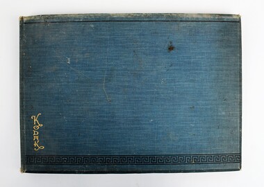 Ringwood RSL Sub-Branch
Photo Album, Capt. A. Greig, C. WW1
Captures a soldeirs experiences in Egypt including rare photos of the everyday life and experiences of a soldier.Possibly a rare collection of a WW1 soldiers experiences captured in photographsBound album with cardboard front and back covered in aqua fabric. Greek scroll decoration on bottom, KODAK gold lettering, frontleft. 11 pages plus one cut in half. Each pages contain four photo pockets with black and white photos. Each photo has handwritten description on bottom of pocket. Photos depict Mena Camp, Egypt.1914 /1915, warships in Mudrus harbour, hospital ship and photos of soldiers with local people. Photos missing.Each photo inscribed below image with information about location. Top Right inside cover Donated by R.F. Ormaton, Box Hill. Photos belong to Capt. A. Greig Dec. 1988. Also written top left ‘J. Crowley / 105 Ocean Street/ Rosebud/ (059) 861246world war 1, ww1 -
 Orbost & District Historical Society
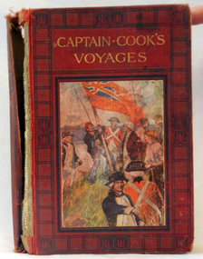
book, Cassell and Company Limited, Captain Cook's Voyages, 1908
James Cook was a British explorer, navigator, cartographer, and captain in the Royal Navy. Cook made detailed maps of Newfoundland prior to making three voyages to the Pacific Ocean, during which he achieved the first recorded European contact with the eastern coastline of Australia and the Hawaiian Islands, and the first recorded circumnavigation of New Zealand.Cook's 12 years sailing around the Pacific Ocean contributed much to European knowledge of the area. This is a useful reference book.A 446pp hard back book titled, "Captain Cook's Voyages" in gold print. It has a black and red cover with a coloured illustration of the landing of James Cook, his crew and the planting of the British red ensign. It has coloured illustrations. Includes Aboriginal encounters with explorers. inside cover - :To Fred from his mother, mas 1910" -
 Australian National Surfing Museum
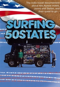
DVD Movie, Surfing 50 States, Circa 2008
Cult Australian surf travel documentary made by Stefan Hunt and Jonno Durrant as they endeavour to surf 50 states of the United States of America in 50 days (32 without an ocean). Music by Spiderbait, The Wahas and many more. World Premier at the Hayden Orpheum Picture Palace, Cremorne, Sydney on 15th October, 2008.On of the most popular independent surf travel documentaries ever made. Unique insight into surfing and popular culture.Colour cover art of an American flag over a sand, movie title and colour photograph of Johnno and Stefan with the infamous Hurley Van.Movie title, one line synopsisjonno durrant, stefan hunt, surfing 50 states, spiderbait -
 Uniting Church Archives - Synod of Victoria
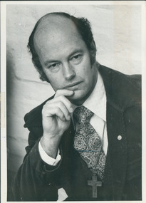
Photograph, Peter Moonie, 14/08/1985
Reverend Peter Moonie (10/11/1933 - 08/12/2013) was ordained as a Methodist minister in 1961. He served at on King Island and at Launceston South, in the United States at Salem New Hampshire and Agawam Massachusetts, Church of All Nations, Box Hill Regiobnal Parish and Ocean Grove. He retired in 1995.B & W waist length photograph of Rev. Peter Moonie."Peter Moonie C&N 14/8/1985 page 15"moonie, peter, methodist minister -
Unions Ballarat
Secrets of State: A Detailed Assessment of the Book They Banned, Munster, George, 1982
Secret (leaked) government documents dealing with East Timor, US military bases in Australia, the Soviet Navy in the Indian Ocean, the Shah’s regime in Iran and the Vietnam War. Originally published as "Documents on Australian Defence and Foreign Policy 1968-1975" - this edition was previously banned and all unsold copies were destroyed by the government.Significant to Australian foreign relations in the period 1968-1975.Paper; book. Front cover: black background; pictures of newspapers and a book; red and white text.Front cover: author's name and title.btlc, ballarat trades hall, ballarat trades and labour council, east timor, us military bases, soviet navy, vietnam, iran, vietnam war, documents on australian defence and foreign policy, government leaks, shah of iran