Showing 2473 items
matching district views
-
![Photograph - Digital Image, Greensborough Cemetery [view 3] 2013, 18/06/2013](/media/collectors/4f729f5697f83e03086015b8/items/54c5f91f2162f1173055ddc2/item-media/54c5f9512162f1173055dfc8/item-fit-380x285.jpg) Greensborough Historical Society
Greensborough Historical SocietyPhotograph - Digital Image, Greensborough Cemetery [view 3] 2013, 18/06/2013
View of Greensborough Cemetery, June 18th 2013. Photography by Marilyn Smith.Greensborough Cemetery was created when land was given for the cemetery by Mr William Poulter, a local settler, about 1864. The cemetery holds the graves of many early settlers in the district. Digital copy of colour photograph of Greensborough Cemeterygreensborough cemetery -
![Photograph - Digital Image, Greensborough Cemetery [view 2] 2014, 28/05/2014](/media/collectors/4f729f5697f83e03086015b8/items/54c5f9d52162f1173055e7b3/item-media/54c5fa9f2162f1173055f50b/item-fit-380x285.jpg) Greensborough Historical Society
Greensborough Historical SocietyPhotograph - Digital Image, Greensborough Cemetery [view 2] 2014, 28/05/2014
View of Greensborough Cemetery, 28th May 2014. Photography by Marilyn Smith.Greensborough Cemetery was created when land was given for the cemetery by Mr William Poulter, a local settler, about 1864. The cemetery holds the graves of many early settlers in the district. Digital copy of colour photograph of Greensborough Cemeterygreensborough cemetery -
![Photograph - Digital Image, Greensborough Cemetery [view 3] 2014, 28/05/2014](/media/collectors/4f729f5697f83e03086015b8/items/54c5fab02162f1173055f6ef/item-media/54c5fadf2162f1173055faf6/item-fit-380x285.jpg) Greensborough Historical Society
Greensborough Historical SocietyPhotograph - Digital Image, Greensborough Cemetery [view 3] 2014, 28/05/2014
View of Greensborough Cemetery, 28th May 2014. Photography by Marilyn Smith.Greensborough Cemetery was created when land was given for the cemetery by Mr William Poulter, a local settler, about 1864. The cemetery holds the graves of many early settlers in the district. Digital copy of colour photograph of Greensborough Cemeterygreensborough cemetery -
![Photograph - Digital Image, Greensborough Cemetery [view 4] 2014, 28/05/2014](/media/collectors/4f729f5697f83e03086015b8/items/54c5fb402162f1173055ff6a/item-media/54c5fb702162f117305602cc/item-fit-380x285.jpg) Greensborough Historical Society
Greensborough Historical SocietyPhotograph - Digital Image, Greensborough Cemetery [view 4] 2014, 28/05/2014
View of Greensborough Cemetery, 28th May 2014. Photography by Marilyn Smith.Greensborough Cemetery was created when land was given for the cemetery by Mr William Poulter, a local settler, about 1864. The cemetery holds the graves of many early settlers in the district. Digital copy of colour photograph of grave/headstone.greensborough cemetery -
![Photograph - Digital Image, Greensborough Cemetery [view 5] 2014, 28/05/2014](/media/collectors/4f729f5697f83e03086015b8/items/54c5fbcf2162f11730560d50/item-media/54c5fc022162f11730560fbb/item-fit-380x285.jpg) Greensborough Historical Society
Greensborough Historical SocietyPhotograph - Digital Image, Greensborough Cemetery [view 5] 2014, 28/05/2014
View of Greensborough Cemetery, 28th May 2014. Photography by Marilyn Smith.Greensborough Cemetery was created when land was given for the cemetery by Mr William Poulter, a local settler, about 1864. The cemetery holds the graves of many early settlers in the district. Digital copy of colour photograph of Greensborough Cemeterygreensborough cemetery -
![Photograph - Digital image, Greensborough Cemetery [view 5], 08/03/2012](/media/collectors/4f729f5697f83e03086015b8/items/54c4afd22162f1070475eca3/item-media/54c4b0222162f1070475f0d9/item-fit-380x285.jpg) Greensborough Historical Society
Greensborough Historical SocietyPhotograph - Digital image, Greensborough Cemetery [view 5], 08/03/2012
View of Greensborough Cemetery on 8/3/2012. Photograph taken by Jasmin Burge.Greensborough Cemetery was created when land was given for the cemetery by Mr William Poulter, a local settler, about 1864. The cemetery holds the graves of many of the early settlers in the district. The cemetery holds approximately 250 grave sites with 350 people buried there. Digital copy of colour photograph of cemetery.greensborough cemetery -
![Photograph - Digital image, Greensborough Cemetery [view 6], 26/07/2011](/media/collectors/4f729f5697f83e03086015b8/items/54c4b0aa2162f1070475f8a9/item-media/54c4b0df2162f1070475fb80/item-fit-380x285.jpg) Greensborough Historical Society
Greensborough Historical SocietyPhotograph - Digital image, Greensborough Cemetery [view 6], 26/07/2011
View of Greensborough Cemetery 26/07/2011. Photograph taken by Jasmin Burge.Greensborough Cemetery was created when land was given for the cemetery by Mr William Poulter, a local settler, about 1864. The cemetery holds the graves of many of the early settlers in the district. The cemetery holds approximately 250 grave sites with 350 people buried there. This photo captures the grave of Giles Poulter.Digital copy of colour photograph of cemetery.greensborough cemetery -
![Photograph - Digital image, Greensborough Cemetery [view 7], 04/10/2011](/media/collectors/4f729f5697f83e03086015b8/items/54c4b1412162f107047606db/item-media/54c4b1702162f10704760d3a/item-fit-380x285.jpg) Greensborough Historical Society
Greensborough Historical SocietyPhotograph - Digital image, Greensborough Cemetery [view 7], 04/10/2011
View of Greensborough Cemetery 04/10/2011. Photograph taken by Jasmin Burge.Greensborough Cemetery was created when land was given for the cemetery by Mr William Poulter, a local settler, about 1864. The cemetery holds the graves of many of the early settlers in the district. The cemetery holds approximately 250 grave sites with 350 people buried there. Digital copy of colour photograph of cemetery.greensborough cemetery -
![Photograph - Digital image, Greensborough Cemetery [view 2], 08/03/2012](/media/collectors/4f729f5697f83e03086015b8/items/54c4b1cd2162f10704761367/item-media/54c4b1fd2162f1070476170e/item-fit-380x285.jpg) Greensborough Historical Society
Greensborough Historical SocietyPhotograph - Digital image, Greensborough Cemetery [view 2], 08/03/2012
View of Greensborough Cemetery 08/03/2012. Photograph taken by Jasmin Burge.Greensborough Cemetery was created when land was given for the cemetery by Mr William Poulter, a local settler, about 1864. The cemetery holds the graves of many of the early settlers in the district. The cemetery holds approximately 250 grave sites with 350 people buried there. Digital copy of colour photograph of cemetery.greensborough cemetery -
![Photograph - Digital image, Greensborough Cemetery [view 3], 26/07/2011](/media/collectors/4f729f5697f83e03086015b8/items/54c4b25a2162f10704761bfa/item-media/54c4b2882162f10704761e1b/item-fit-380x285.jpg) Greensborough Historical Society
Greensborough Historical SocietyPhotograph - Digital image, Greensborough Cemetery [view 3], 26/07/2011
View of Greensborough Cemetery 26/07/2011. Photograph taken by Jasmin Burge.Greensborough Cemetery was created when land was given for the cemetery by Mr William Poulter, a local settler, about 1864. The cemetery holds the graves of many of the early settlers in the district. The cemetery holds approximately 250 grave sites with 350 people buried there. Digital copy of colour photograph of cemetery.greensborough cemetery -
![Photograph - Digital image, Greensborough Cemetery [view 4], 26/07/2011](/media/collectors/4f729f5697f83e03086015b8/items/54c4b2e12162f10704762248/item-media/54c4b30e2162f107047625ec/item-fit-380x285.jpg) Greensborough Historical Society
Greensborough Historical SocietyPhotograph - Digital image, Greensborough Cemetery [view 4], 26/07/2011
View of Greensborough Cemetery 26/07/2011. Photograph taken by Jasmin Burge.Greensborough Cemetery was created when land was given for the cemetery by Mr William Poulter, a local settler, about 1864. The cemetery holds the graves of many of the early settlers in the district. The cemetery holds approximately 250 grave sites with 350 people buried there. Digital copy of colour photograph of cemetery.greensborough cemetery -
![Photograph - Digital image, Greensborough Cemetery [view of damage], 04/10/2011](/media/collectors/4f729f5697f83e03086015b8/items/54c4b3b12162f10704762f8a/item-media/54c4b3e62162f1070476341a/item-fit-380x285.jpg) Greensborough Historical Society
Greensborough Historical SocietyPhotograph - Digital image, Greensborough Cemetery [view of damage], 04/10/2011
View of damaged grave in Greensborough Cemetery 04/10/2011. Photograph taken by Jasmin Burge.Greensborough Cemetery was created when land was given for the cemetery by Mr William Poulter, a local settler, about 1864. The cemetery holds the graves of many of the early settlers in the district. The cemetery holds approximately 250 grave sites with 350 people buried there. Digital copy of colour photograph of cemetery.greensborough cemetery -
![Photograph - Digital image, Greensborough Cemetery [sign], 26/07/2011](/media/collectors/4f729f5697f83e03086015b8/items/54c4b4762162f10704764028/item-media/54c4b4a82162f10704764420/item-fit-380x285.jpg) Greensborough Historical Society
Greensborough Historical SocietyPhotograph - Digital image, Greensborough Cemetery [sign], 26/07/2011
View of Greensborough Cemetery, including sign 26/07/2011. Photograph taken by Jasmin Burge.Greensborough Cemetery was created when land was given for the cemetery by Mr William Poulter, a local settler, about 1864. The cemetery holds the graves of many of the early settlers in the district. The cemetery holds approximately 250 grave sites with 350 people buried there. Digital copy of colour photograph of cemetery including sign.greensborough cemetery -
![Photograph - Digital image, Greensborough Cemetery [view 8], 26/07/2011](/media/collectors/4f729f5697f83e03086015b8/items/54c4b51b2162f1070476504c/item-media/54c4b54c2162f107047653e7/item-fit-380x285.jpg) Greensborough Historical Society
Greensborough Historical SocietyPhotograph - Digital image, Greensborough Cemetery [view 8], 26/07/2011
View of Greensborough Cemetery 26/07/2011. Photograph taken by Jasmin Burge.Greensborough Cemetery was created when land was given for the cemetery by Mr William Poulter, a local settler, about 1864. The cemetery holds the graves of many of the early settlers in the district. The cemetery holds approximately 250 grave sites with 350 people buried there. Digital copy of colour photograph of cemetery.greensborough cemetery -
![Photograph - Digital image, Greensborough Cemetery [view 1], 18/06/2013](/media/collectors/4f729f5697f83e03086015b8/items/54c5f72c2162f1173055bbb2/item-media/54c5f7722162f1173055c101/item-fit-380x285.jpg) Greensborough Historical Society
Greensborough Historical SocietyPhotograph - Digital image, Greensborough Cemetery [view 1], 18/06/2013
View of Greensborough Cemetery, June 18th 2013. Photography by Marilyn Smith.Greensborough Cemetery was created when land was given for the cemetery by Mr William Poulter, a local settler, about 1864. The cemetery holds the graves of many early settlers in the district. Digital copy of colour photograph of Greensborough Cemeterygreensborough cemetery -
![Photograph - Digital Image, Greensborough Cemetery [view 2] 2013, 18/06/2013](/media/collectors/4f729f5697f83e03086015b8/items/54c5f8802162f1173055d3d6/item-media/54c5f8ba2162f1173055d66a/item-fit-380x285.jpg) Greensborough Historical Society
Greensborough Historical SocietyPhotograph - Digital Image, Greensborough Cemetery [view 2] 2013, 18/06/2013
View of Greensborough Cemetery, June 18th 2013. Photography by Marilyn Smith.Greensborough Cemetery was created when land was given for the cemetery by Mr William Poulter, a local settler, about 1864. The cemetery holds the graves of many early settlers in the district. Digital copy of colour photograph of Greensborough Cemeterygreensborough cemetery -
![Photograph - Digital Image, Greensborough Cemetery [view 1] 2014, 28/05/2014](/media/collectors/4f729f5697f83e03086015b8/items/581060aed0cdd12660a1c09d/item-media/581060f6d0cdd12660a1ece7/item-fit-380x285.jpg) Greensborough Historical Society
Greensborough Historical SocietyPhotograph - Digital Image, Greensborough Cemetery [view 1] 2014, 28/05/2014
View of Greensborough Cemetery, 28th May 2014. Photography by Marilyn Smith.Greensborough Cemetery was created when land was given for the cemetery by Mr William Poulter, a local settler, about 1864. The cemetery holds the graves of many early settlers in the district. Digital copy of colour photograph of Greensborough Cemetery -
 Glenelg Shire Council Cultural Collection
Postcard - Postcard - Western District and Mt Gambier, n.d
... Full colour multi-view postcard. 9 views of Western... postcard. 9 views of Western district and Mt Gambier, including ...Full colour multi-view postcard. 9 views of Western district and Mt Gambier, including Portland and Cape Bridgewater. -
Glenelg Shire Council Cultural Collection
Photograph - Photograph - Aged Care Facility Casterton, c. 1963
Sourced from Casterton Town Hall (Former Shire of Glenelg)Black and white photo. Front view of 'Edgarley' Aged Care Facility, CastertonBack: Black stamp - 003826 'Casterton and District Aged Care Facility. "Edgarley" ', handwritten, blue biro. Blue biro line, arrowed both ends, drawn across photo. 3'' written above line -
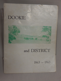 Dookie Historical Society
Soft Cover Dookie District History Book - Width 18.5cm x Height 24cm Consist of 33 pages (not numbered), The General Committee Organising the Dookie Back To, Dookie and District 1863 - 1963, Easter 1963 "WATERWHEEL PRESS,"
Soft Cover Historical Book - White Background with 2 green and white soft aerial photographs of prominent landmarks at Dookie. Front Cover - Mount Major on the left and Saddleback on the right. Back Cover - An aerial view of Dookie as it is today, showing the Grain Elevators Board wheat silos under construction (lower right foreground). -
Glenelg Shire Council Cultural Collection
Souvenir - Postcard, c. 2000
Contemporary postcard of Portland. 4 full colour views of Portland. 'Portland Victoria, Australia' in white on blue bottle margin, left. Traveller's Notes logo on right. Reverse has line map of Australia. Melbourne indicated, plus rectangular area Portland district. Valued $ 30.15 for 9 items -
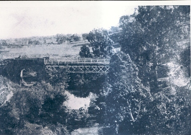 Greensborough Historical Society
Photographs, Greensborough Views, 1900c
... Various views of Greensborough & district in the early 1900... Plenty Lower Plenty melbourne Various views of Greensborough ...Various views of Greensborough & district in the early 1900's.Records the houses, roads and bridge in Greensborough.2 copies of early Greensborough district photographs.Nilgreensborough, bluestone bridge, main street, aqueduct bridge, plenty river -
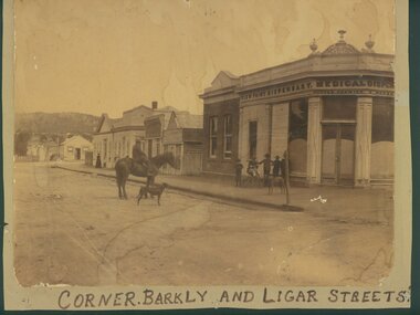 Ararat & District Historical Society (operating the Langi Morgala Museum)
Photograph
An early streetscape of Ararat's central business district.Sepia photograph of a shop on a corner. Written on the shop front is View Point Dispensary Medical Dispensary. Five young boys and a dog are standing in front of the shop while a man is seated on a horse beside a dog.Written on front" Corner of Barkly and Ligar Streets -
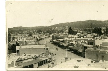 Ararat & District Historical Society (operating the Langi Morgala Museum)
Postcard
A black and white photographic postcard of a view of Barkly Street with Copes Hill in the background. Photo taken from Town Hall. Horse drawn vehicle in street scene. Shop front signs legible: A. Waugh Ready Money Draper, Albion Hotel, aganet for Brunnings, TRG Williams Photographer, E.I. Beynan, Fergusson's. -
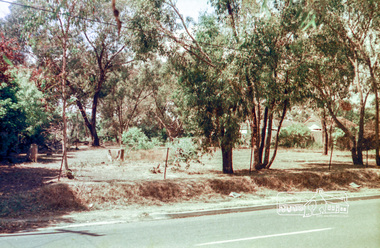 Eltham District Historical Society Inc
Photograph, Mountain View Road, Briar Hill, c.1976, 1976c
Taken opposite No., 140Streetscape development over timeRoll of 35mm colour negative film, 2 stripsAgfa CN S602mountain view road, briar hill -
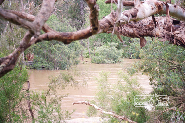 Eltham District Historical Society Inc
Photograph, Peter Pidgeon, Yarra River flooded, confluence with Diamond Creek viewed from lookout at Lenister Farm, Eltham, 2004
Digital file onlyfloods, diamond creek, yarra river, lenister farm -
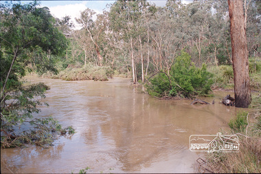 Eltham District Historical Society Inc
Photograph, Peter Pidgeon, Yarra River flooded, confluence with Diamond Creek viewed from lookout at Lenister Farm, Eltham, 2004
Digital file onlyfloods, diamond creek, yarra river, lenister farm -
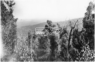 Eltham District Historical Society Inc
Photograph, View from the Mountain Trail, Kinglake
Source: Mrs. McMinn, KinglakeThis photo forms part of a collection of photographs gathered by the Shire of Eltham for their centenary project book,"Pioneers and Painters: 100 years of the Shire of Eltham" by Alan Marshall (1971). The collection of over 500 images is held in partnership between Eltham District Historical Society and Yarra Plenty Regional Library (Eltham Library) and is now formally known as the 'The Shire of Eltham Pioneers Photograph Collection.' It is significant in being the first community sourced collection representing the places and people of the Shire's first one hundred years.Digital imagesepp, shire of eltham pioneers photograph collection, kinglake, mountain trail -
 Eltham District Historical Society Inc
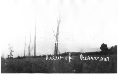
Photograph, View of Reservoir from Kinglake
View is of Yan Yean Reservoir, probably taken from Council land (1970) on Ganglehoffs Road.This photo forms part of a collection of photographs gathered by the Shire of Eltham for their centenary project book,"Pioneers and Painters: 100 years of the Shire of Eltham" by Alan Marshall (1971). The collection of over 500 images is held in partnership between Eltham District Historical Society and Yarra Plenty Regional Library (Eltham Library) and is now formally known as the 'The Shire of Eltham Pioneers Photograph Collection.' It is significant in being the first community sourced collection representing the places and people of the Shire's first one hundred years.Digital image and 4 x 5 inch B&W Negsepp, shire of eltham pioneers photograph collection, kinglake, reservoir, ganglehoffs road, yan yean reservoir -
 Eltham District Historical Society Inc
Negative - Photograph, Kinglake National Park; view from the Mountain Trail
The Kinglake National Park was established on 11,300 acres in the Shire of Eltham in 1928.This photo forms part of a collection of photographs gathered by the Shire of Eltham for their centenary project book,"Pioneers and Painters: 100 years of the Shire of Eltham" by Alan Marshall (1971). The collection of over 500 images is held in partnership between Eltham District Historical Society and Yarra Plenty Regional Library (Eltham Library) and is now formally known as 'The Shire of Eltham Pioneers Photograph Collection.' It is significant in being the first community sourced collection representing the places and people of the Shire's first one hundred years.Digital image 4 x 5 inch B&W Negsepp, shire of eltham pioneers photograph collection, kinglake, kinglake national park, mountain trail