Showing 4376 items
matching walls
-
 Robin Boyd Foundation
Slide, Robin Boyd, 1961
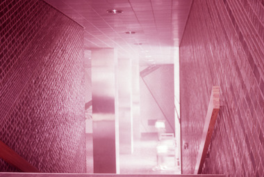
Robin Boyd wrote two books on Japanese architects and architecture - “Kenzo Tange” published by George Braziller in 1962 and “New Directions in Japanese Architecture” published by Studio Vista in 1968. During the 1960s he travelled several times to Japan to research these books and as part of his role as Exhibits Architect for the Australian Pavilion at Expo ‘70 in Osaka. Colour slide in a mount. Interior (staircase and tiled walls), Okayama Prefectural Government Building, Okayama, Japan, 1957. (Architect: Kunio Maekawa.)Made in Australia / 7slide, robin boyd, japan -
 National Trust of Australia (Victoria)
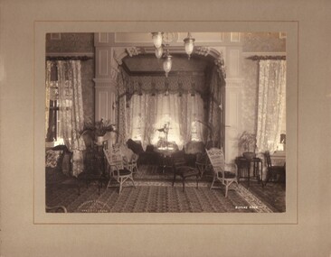
Photograph, Drawing room, c1903
Black and white photograph mounted on light grey coloured card. Photograph shows Sargood's Sitting Room taken from the East wall.Stamped onto front left bottom corner of photograph: 'Johnstone & O'Shannessy/ & Co./ Propy. Ltd/ Collins St. Melb.' Written on photograph: 'SITTING ROOM' sargood family, rippon lea -
 Whitehorse Historical Society Inc.
Newspaper, A Mural Full of History, 17/04/1996 12:00:00 AM
Team of young Artists will depict Historical Mural on front wall of Blackburn Library, sponsored by Landcare & Environment Action Group, funded by DEET.Team of young Artists will depict Historical Mural on front wall of Blackburn Library, sponsored by Landcare & Environment Action Group, funded by DEET.Team of young Artists will depict Historical Mural on front wall of Blackburn Library, sponsored by Landcare & Environment Action Group, funded by DEET.public libraries, blackburn branch library, landcare & environment action group, australia. department of employment, education and training -
 Ballarat Heritage Services
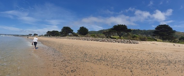
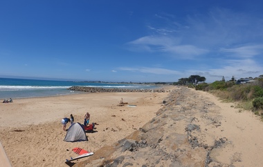
Photograph, Clare Gervasoni, Apollo Bay, Victoria, 24/01/2022
In 2021, the Department of Environment, Land, Water and Planning (DELWP) constructed two new groynes and a section of rock seawall at Apollo Bay to help manage the impacts of coastal erosion. The new 70-meter-long rock groynes run perpendicular to the shoreline and be located just south of the Milford St revetment and to the south of Milford Creek. Sections of rock seawall will be constructed between the two Groynes with an aim to protect the dune, walking path, cypress trees and road from erosion. Colour photograph of a coastal scene at Apollo Bay, featuring new rock wall and groynes to protect the Great Ocean Road from erosion. apollo bay, beach, coast, groyne, rockwall -
 Ballarat Heritage Services
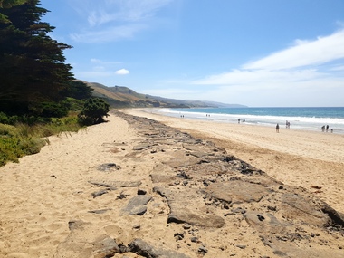
Photograph, Clare Gervasoni, Sea Wall at Apollo Bay, Victoria, 24/01/2022
In 2021, the Department of Environment, Land, Water and Planning (DELWP) constructed two new groynes and a section of rock seawall at Apollo Bay to help manage the impacts of coastal erosion. The new 70-meter-long rock groynes run perpendicular to the shoreline and be located just south of the Milford St revetment and to the south of Milford Creek. Sections of rock seawall will be constructed between the two Groynes with an aim to protect the dune, walking path, cypress trees and road from erosion. Colour photograph of a coastal scene at Apollo Bay, featuring new rock wall and groynes to protect the Great Ocean Road from erosion. apollo bay, beach, coast, groyne, rockwall, sea wall -
 Ballarat Heritage Services
Photograph, Clare Gervasoni, Sea Wall at Apollo Bay, Victoria, 24/01/2022
In 2021, the Department of Environment, Land, Water and Planning (DELWP) constructed two new groynes and a section of rock seawall at Apollo Bay to help manage the impacts of coastal erosion. The new 70-meter-long rock groynes run perpendicular to the shoreline and be located just south of the Milford St revetment and to the south of Milford Creek. Sections of rock seawall will be constructed between the two Groynes with an aim to protect the dune, walking path, cypress trees and road from erosion. Colour photograph of a coastal scene at Apollo Bay, featuring new rock wall and groynes to protect the Great Ocean Road from erosion. apollo bay, beach, coast, groyne, rockwall, sea wall -
 St Matthews/Wiseman House Archive
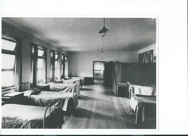
Photograph, St Agnes Girls Home, Lambie Cottage, c.1950s
Lambie Cottage was an addition to St. Agnes Girls' Home, providing more modern accommodation.Development of St Agnes Girls' Home to accommodate additional children in a more modern setting.A b&w photograph of large room with single beds lined up along each wall, bathroom at the end of the room, timber floor.Copied with permission -
 Mt Dandenong & District Historical Society Inc.
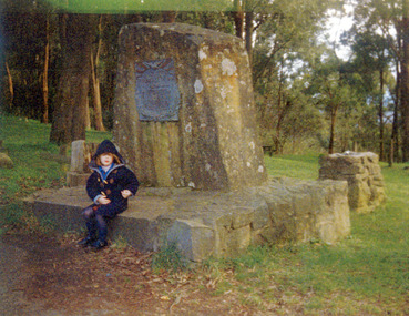
Photograph, The Peace Memorial FiveWays, Kalorama c1994, c1994
Constructed from a single piece of local stone. Ellis Park in background. Child seated is Victoria Wall about 5 years old.fiveways, ellis park, peace memorial -
Southern Sherbrooke Historical Society Inc.
Information folder - Wall family
Information folder containing items pertaining to the Wall family of Menzies Creek. Contents: -article, "The miracle that was Bessie", The Mail, 27th January 2004bessie wall, wall family, menzies creek, st cuthberts church, mr & mrs percy douglas, norma marshall -
 Australian Army Museum of Western Australia
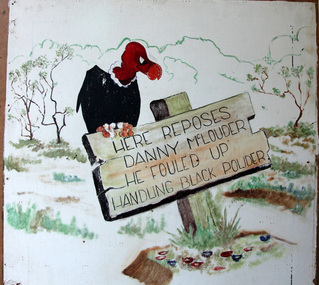
Grafitti
No documentation available.Wall panel retrieved from Midland ammunition deport. "Here reposes Danny McLouder. He fouled up handling black powder" -
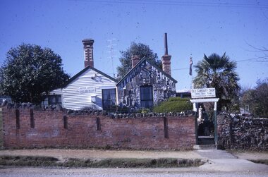 Ballarat Tramway Museum
Slide - 35mm slide/s, Les Fordham, Aug. 1967
Kodachrome white cardboard mount 35mm slides - dated August 1967 taken by Les Fordham of the Old Curiosity Shop side and wall.tramways, trams, curiosity shop, tourism -
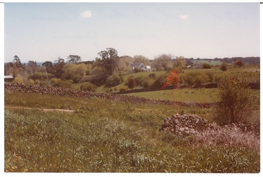 Buninyong & District Historical Society
Photograph - Original Photograph, View from Lal Lal St. 1982, 1982
Colour photograph, view from Lal Lal St. looking west in1982, drystone wall runs across, catholic church in backgroundbuninyong, lal lal street, drystone wall, catholic church, landscape -
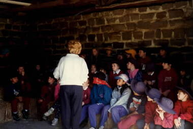 Sunbury Family History and Heritage Society Inc.
Photograph, School Excursion, cEarly 1990s
The students from Bulla Primary School were taken to one of the farms in the local area to introduce them farm life.A non-digital coloured photograph of a group of children sitting on hay bales in a dingy farm building with bluestone walls. A lady is supervising the children.school excursions, bulla primary schooil, farms -
 University of Melbourne, Burnley Campus Archives
Photograph - Black and white print, Information Branch Victorian Department of Agriculture, Student Year Group, Unknown
2 copies black and white photograph. Group photograph of students seated on chairs in front of a wall. Year not identified. What they represent not identified.On reverse, "Photograph by Information Branch Victorian Department Of Agriculture Ref. No. D.1441?.A."students, student group. -
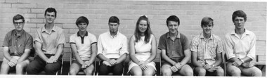
 St Patrick's Old Collegians Association (SPOCA)
Photograph - Students, 1930s
-
 Linton and District Historical Society Inc
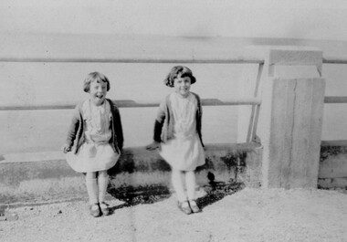
Photograph, Reilly Twins at the Seaside, circa 1925, 1925
Part of photograph album donated by Mrs Faull. Mr Reilly was Grenville Shire Engineer 1923-1930 Girls approximately 8 years old on a day at the seaside.Sepia photograph of two young girls wearing short summer dresses and cardigans sitting beside each other on low wall at seaside.reilly twins, faull collection -
 Kiewa Valley Historical Society
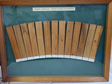
Timber Samples - Upper Kiewa Catchment
13 strips of wood showing their different colour and grain and representing trees found in the Kiewa Catchment.A record of timber found in the Upper Kiewa Catchment13 different types of wood displayed in a wooden framed picture/wall hanging. Each wood is labelled. Green background and wooden frame.Labelled: Timber Samples - Upper Kiewa Catchmenttimber samples, upper kiewa catchment -
 Wodonga & District Historical Society Inc
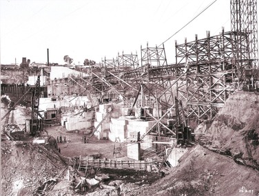
Album - Hume Reservoir Australia Album - Work proceeding inside the coffer dam (2), August 1927
This set of photos is from a leather bound album bearing the inscription "HUME RESERVOIR AUSTRALIA" plus 'The Rt. Hon. L. C. M. S. Amery, P. C., M .P.' all inscribed in gold. It was presented to The Rt. Hon. L. C. M. S. Amery, P. C., M. P, Secretary of State for Dominion Affairs on the occasion of his visit to the Hume Reservoir on 2nd November 1927. This album is of local and national significance as it documents the planning and development of the Hume Reservoir up to 1927. It was the largest water reservoir in the British Empire. The album records the pioneering engineering work that went into its construction.DEPARTMENT OF PUBLIC WORKS, N.S.W. RIVER MURRAY WATERS SCHEME. HUME RESERVOIR. 26. Work proceeding inside the coffer dam. This view was taken from the edge of the cut for the South Wing Wall foundations looking from the opposite direction to that of the preceding photograph, the curving downstream face of the main wall being seen beyond the steam navvy. This view shows the way in which the concrete paddocks are stepped and broken jointed vertically and horizontally. In the distance is the North Wing Wall and Power House stack beyond it. New South Wales, August 1927.hume reservoir australia, river murray waters scheme, hume reservoir construction -
Glenelg Shire Council Cultural Collection
Container - Tin, n.d
Displayed in History House (Cabinet, South wall)Green tin with lid. Pictures on front.domestic item, kitchen, food container, tin -
 Glenelg Shire Council Cultural Collection
Domestic object - Drinking Glass, n.d
Displayed in History House (Cabinet, South wall)Blue glass with gold and white hand-painted floral pattern.domestic, drinking, food and drink -
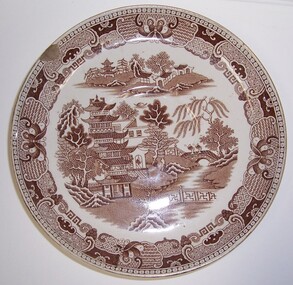 Glenelg Shire Council Cultural Collection
Domestic object - Plate - "Willow pattern plate", n.d
Displayed in History House (Cabinet, South wall)Willow-pattern plate with brown design.Front: Base: Willow/AF & S (brown print, centre) -
 Eltham District Historical Society Inc
Photograph, The Pavilion, Eltham Living and Learning Centre, September 1994, 1994
Note: no garden retaining wall and no stairs to verandah Colour photographeltham, eltham living and learning centre, living and learning centre, pavilion, shire of eltham -
 Stawell Historical Society Inc
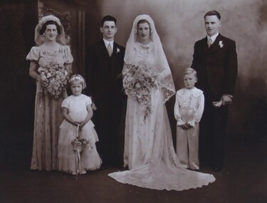
Photograph, Mr Dick Warren & Miss Pearl Wall's Wedding Group Portrait with names 1938
Wall – Warren Wedding Group Portrait (1938)stawell -
Port Melbourne Historical & Preservation Society
Footwear - Child's boot, c.1920
Found in the wall cavity of a house in Princes Street.Child's leather boot with part of a bootlace made out of string. built environment - domestic, footwear -
 The Beechworth Burke Museum
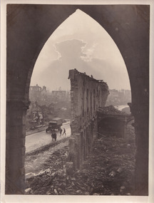
Photograph, 5 November 1917
Taken on the 5 November 1917 by James Francis Hurley, this photograph depicts the a war damaged Ypres. The shell damaged wall of the Cloth Hall is featured in the centre of the photograph, with an army vehicle and personal are located on the street beneath the ruined wall.First Battle of Ypres, (October 19–November 22, 1914), first of three costly World War I battles centred on the city of Ypres (now Ieper) in western Flanders. Attempted flank attacks by both the Allies and the Germans failed to achieve significant breakthroughs, and both sides settled into the trench warfare that would characterize the remainder of the war on the Western Front.Black and white rectangular reproduced photograph printed on mate photographic paperReverse: 6525/ (A copyright and reproduction notice from the Australian War Museum, printed upside-down in blue ink)military album, burke museum, world war one, world war 1, ww1, ypres, belguim, ruins, first battle of ypres, james francis hurley -
 Eltham District Historical Society Inc
Photograph, Harry Gilham, Renovations to Eltham State School No. 209, Dalton Street, Eltham, 1994
Floor track in the 1921 infants room (now staff room). Wall recess appears in some 1900-1906 school group photographs which used the east end wall as their backdrop with Head Teacher John Brown present.Handwritten (HG's) information and details in blue ink on reverse sidedalton street, eltham primary school, renovations, building construction, buildings, eltham state school no. 209 -
Tatura Irrigation & Wartime Camps Museum
Photograph, 24/3/1917
Taken by photographer for State Rivers and Water Supply Commission.Medium sized black and white photograph. Sugarloaf Reservoir upper core wall, tower, tunnel, and lower dam under construction / Group of men left corner / Rocks in river bed foreground / Horse and cart off-centre left / Horse, cart, and men far right of centre / Words "Diversion Core Wall Tunnel and Riverbed" printed.victorian state rivers and supply commission, sugarloaf reservoir -
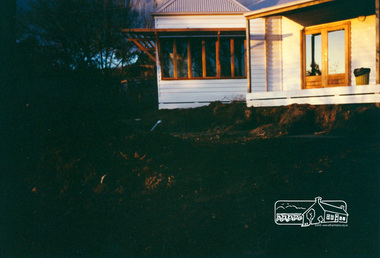
 Eltham District Historical Society Inc
Photograph, Former Eltham Police Residence, 728 Main Road, Eltham, c.1985, 1985c
This photo is believed to have been taken circa 1985 when the Shire of Eltham Parks and Environment occupied the site. This photo was originally mounted on 3mm MDF fibre board with notes and stickers applied as part of a display on the former Police Residence and now present day Local History Centre, home to Eltham District Historical Society; possibly put together by Harry Gilham during his time as president of the society. Eltham Police Station and Residence: A brief history 1860 Eltham Courthouse built in Main Road, together with an adjoining police residence, office, lock–up and stables. 1959 Police Department purchases a house in Pryor Street to be refurbished as Eltham Police Station 1961 Police in Eltham move into Pryor Street refurbished buildings and office. c.1961-1981 Occupied by Vermin and Noxious Weeds Destruction Section of the Department of Crown Lands and Survey. Former Police Station dragged around to rear of Police Residence (prior to August 1967) to make way for the construction of a driveway and access from Main Road. The building was placed on the site of a former Scullery and modified for Lands Department use. 1981 Shire of Eltham take over management of old Police Residence in Eltham. It remains unoccupied for a period of time whilst its future is discussed in Council. 1981-1985 Used for community job creation scheme 1985 Shire of Eltham Parks and Environment occupy the residence. Council improve the driveway but later add a second rear access from Brougham Street due to the dangerous nature of the Main Road entrance. Also add a rear toilet facility between the Police Residence and former Police Station, which was doubling up as a lunch room. Council also commence discussions to re-establish a replica Police Station. c.1986 November. Former Police Station demolished; believed to have been suffering termite damage. c.1989 After some years of discussion a replica Police Station is built, based on photographs, to act as a lunch room and meeting room for Parks and Environment staff and volunteers doing community service. 1996 Eltham District Historical Society in discussions with Nillumbik Shire Council commisioners throughout the year regarding a home for the Society. A proposal put forward by the Society in October to occupy the former Police Residence. 1997 March. Eltham District Historical Society gains access to former Police Residence. 1998 July 12th. Eltham District Historical Society Inc moves into its Local History Centre, 728 Main Road Eltham (the former Police Residnce built in 1860). 2018 July. Eltham District Historical Society gains access to the replica Police Station for use as part of regular heritage tours for schools and community based groups.Colour printHandwritten in faded blue felt pen ink "No. 1 South wall of 728 & back of house built 1860 [1859]. Demolition of weatherboard extension into yard area"728 main road, eltham, local history centre, parks and environment, police residence, police station, shire of eltham -
 Bendigo Military Museum
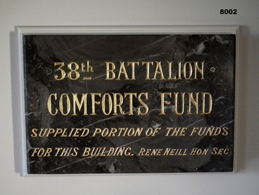
Plaque - PLAQUE, 38TH BN COMFORTS FUND, 38th Battalion Comforts Fund, C.1921
This plaque was originally placed in the Foyer (Vestibule on original plans) of the Soldiers Memorial Institute Bendigo in 1921. After closure in 2016-18 for the renovations to SMI the plaque was then placed in what was originally called the "Writing Room" now called "The Building and RSL History Room". The plaque had the gold paint renewed about 2012 - 15.Plaque marble, grey with streaks of white through, inscription is engraved with Gold paint. The plaque is attached via 2 screws to a backing board on a wall."38th BATTALION COMFORTS FUND supplied portion of the funds for this building. Rene Neill Hon Sec"brsl, smirsl, 38th -
 Christ Church Anglican Parish of Warrnambool
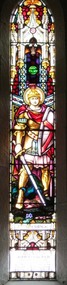
Memorial Window: John FLETCHER, St. George, 1932 - 33
This stained glass lancet window was presented to Christ Church by John Fletcher's immediate relatives as a memento to his Life and influence. He was born in approx. 1856. He died on 24th January 1931, aged 75 years.Stained glass, lancet window, west wall, north nave, left window in group of five lights, depicting St. George slaying the dragon.St George To the Glory of God/ in loving memory of/John Fletcher/ who departed into rest/on the 24th January 1931/ This window was erected by his/ immediate relatives as a loving/ memento to his Life and Influence