Showing 113079 items
matching road
-
 Whitehorse Historical Society Inc.
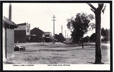
Photograph, Whitehorse Road Mitcham
Black and white photo of Whitehorse Road, Mitchamwhitehorse road mitcham -
 Whitehorse Historical Society Inc.
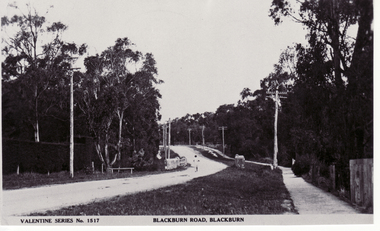
Photograph - Postcard, Blackburn Road Blackburn, 1936
Black and white photo of Blackburn Road (captioned)blackburn road, blackburn -
 Whitehorse Historical Society Inc.
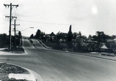
Photograph, Canterbury Road Vermont, 1968
Black and white photo of Canterbury Road, Vermontcanterbury road, vermont -
 Old Colonists' Association of Ballarat Inc.
Work on paper, Francois Cogne, Part of Main Road 1859
Francois Cogne was born in 1829 in Paris. He worked in Australia between 1856 and 1864. He died in 1884.Framed lithograph of buildings on a part of Main Road. francois cogne, biggs and shoppee, main road -
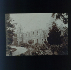
 Vision Australia
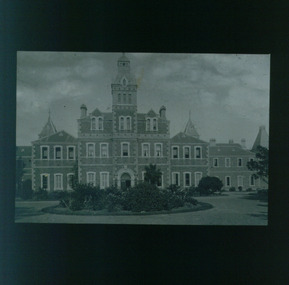
Slide - Image, Talma, Front view of St Kilda Road building, circa 1900
Lantern slide of RVIB taken from the front garden. A circular garden bed outside the main entrance is filled with flowering plants and bushes, and surrounded by a stone driveway. Around the building, bushes, vines and trees have grown. Possibly circa mid 1870 to 1890's, based upon size of trees.Lantern slide of St Kilda Road buildingroyal victorian institute for the blind, buildings -
 Vision Australia
Slide - Image, Talma, Side view of St Kilda Road building, circa 1900
Lantern slide of RVIB taken from the front right hand side garden. The right front side of the building is shown, along with towers, and the garden is filled with trees and bushes. Circa 1880's-1910's given the size of the plants.Lantern slide of St Kilda Road buildingroyal victorian institute for the blind, buildings -
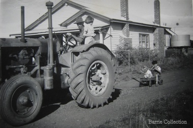 Melton City Libraries
Photograph, The Barrie Family at Ferris Road, 1952
Wendy Elizabeth BARRIE was born on 03 November 1943 in Melbourne, Victoria, Australia, Peter Ernest BARRIE was born on 07 November 1945 in Melbourne, Victoria, Australia, and Heather Marjorie BARRIE was born on 06 July 1949 in Bacchus Marsh, Victoria, Australia.Wendy, Bon, Peter and Heather at Ferris Roadlocal identities, agriculture -
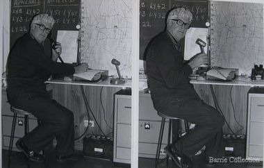 Melton City Libraries
Photograph, Bon Barrie at Ferris Road, Unknown
As Group Communications Officer he operated the VL3 LY base radio station from home on a 24 hour basis for fire brigades of Melton, Rockbank, Sydenham, Diggers Rest, Toolern Vale, Truganina and Werribee. With his brother Edgar, he built the first Melton Fire Truck. It was housed on the family property until a fire station was constructed in the Melton township. Bon at his house on Ferris Road, Meltonlocal identities, emergency services -
Tatura Irrigation & Wartime Camps Museum
Postcard - Post Card, Cesare Vagarini, Country Road, 1991
POW Camp 13 artist. Original owned by Gustav Polig New York USA. Used for post card. In 1943 an agreement was reached to allow POW's to send air mail. Fee was 6 pence for a card, 1 shilling for a letter of which were censored.Coloured photograph country road. Post cardPOW Mailww2 artists, camp 13 -
 Whitehorse Historical Society Inc.
Photograph - Black and white photograph, Whitehorse Road Mitcham
Black and white photo of Whitehorse Road, Mitchamwhitehorse road, mitcham -
Lakes Entrance Regional Historical Society (operating as Lakes Entrance History Centre & Museum)
Postcard, 1922 c
Also three postcards showing different views of the road around Jemmys Point 05281.1, .2 and .3Black and white postcard showing view of new alignment of the Princes Highway on Jemmys Point and part of the original high steep road approaching Lakes Entrance VictoriaThe New Road Lakes Entranceboats and boating, tourism, waterways -
 Ringwood and District Historical Society
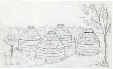
Work on paper - Pencil sketch, Artist unknown, initials D.M, Sketch of pottery kilns at East Ringwood, corner of Velma Grove and Mount Dandenong Road (Oxford Road). Kilns shut down in 1926, c.1926
Sketch of the four pottery kilns at East Ringwood, corner of Velma Grove and Mount Dandenong Road (Oxford Road). The kilns shut down in 1926. Judging by the handwriting, the artist and author appears to be John Rodaughan, East Ringwood historian, whose other works include history on Burnt Bridge Hotel and other parts of East Ringwood. The back of the sketch includes a rough hand-drawn map, that appears to be of the insulator works area, between Mt Dandenong Road and Evon Avenue. The timeline includes generic milestones in blue ink and those associated with Ringwood in red writing.Kilns; D.M. -
 Orbost & District Historical Society
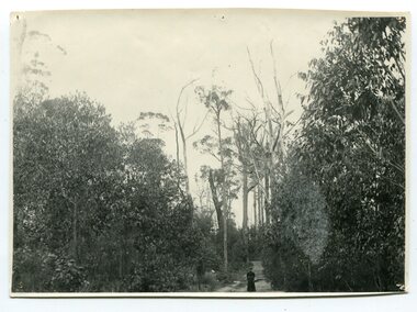
black and white photograph, May 1897
Photo shows an unidentified lady standing on the Orbost / Brodribb Road.A black / white photograph of a women in a long dress standing on a bush road surrounded by dense scrub.on back - " Track near Orbost / Brodribb Road, May 1897"orbost-brodribb-road -
 Halls Gap & Grampians Historical Society
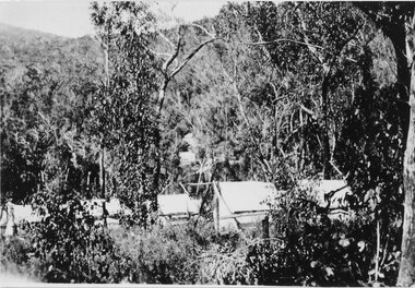
Photograph - Sepia, C 1920s
Photo is said to be that of roadmakers camp for workers on the construction of the Mt Victory RoadPhoto shows a number of tents in bush land, said to be road makers campRoad makers camp Mt Victory Rd during the dat 1920sstructures, tents, access routes, road building -
 Ringwood and District Historical Society
Photograph, South-western view from Marcel Street North Ringwood over Jull Parade to Oban Road - 1981. North Ringwood Sports Reserve is on the left, above the corner of Jull and Oban Roads
Writing on back of photograph reads, "E620. N1. 1981. Looking south-west from Marcel Street North Ringwood over Jull Road to Oban Road. North Ringwood Sports Reserve centre left above corner of Jull and Oban Roads". -
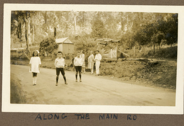 Mt Dandenong & District Historical Society Inc.
Photograph
The photograph is from the album of Ivy Child. The road featured called the 'Main Road' is what we know know as Mt Dandenong Tourist Road. It has been made but not tarred. The identity of the people is unknown. Ivy May Child (1910 – 1989) was the daughter of Arthur Edward (Ted) Child (1878 – 1964) and Ethel May Madden (1888 – 1970). Ted Child was the son of Matthew Francis Child (1839 – 1933) and Martha Jeeves (1857 – 1926). He was the grandson of one of the early pioneers Francis Child. Ivy grew up on the family property on Childs Road and took many photographs. Most of these are glued into her photo album. The album covered the years from c1927 – 1932. Ivy married Henry William Burgess (1906 – 1968) in 1944. The photographs remain in their original state in the album with individual copies made. Sepia coloured photograph showing a stretch of road with two young boys and a girl standing in the middle. Behind them, standing on the edge of the road are two women and a man. Behind them is a wire and post fence with wooden gate and a shed. Bush is visible in the background.Handwritten below the photograph in the album: ALONG THE MAIN ROADivy child, main road, mt dandenong tourist road, tourist road, kalorama -
Port Melbourne Historical & Preservation Society
Book, Rosalie Thrup Bray, "32 Gellibrand Road 3207, Life and times 1941-71", Jul 2013
Written and published by the author. First edition.Book "32 Gellibrand Road 3207, Life and times 1941-71". Rosalie BRAY (THRUP). Green cover with photo of 32 Gellibrand Road on coverbuilt environment - domestic, garden city, education, war - world war ii, piers and wharves - princes pier, gellibrand road, fishermans bend, millie mclean, roy mclean, sandra sleeth, rene smith, dave mclean, phyllis moore, joe watson, nancy carroll, violet pope, len pope, june moore, lois moore, sis peat, mrs mills, mary edwards, alf edwards, judy faram, swallow & ariell ltd, robert harper & co ltd, j h boyd domestic college, mrs wood mewton, oranje, ss nairana, daisy thrup, rosalie (rosie) bray nee thrup -
Port Melbourne Historical & Preservation Society
Book, Rosalie Thrup Bray, "32 Gellibrand Road 3207, Life and times 1941-71", Jul 2013
Written and published by the author. Second edition printed 2014Book "32 Gellibrand Road 3207, Life and times 1941-71". Rosalie BRAY (THRUP). Green cover with photo of 32 Gellibrand Road on coverbuilt environment - domestic, garden city, education, war - world war ii, piers and wharves - princes pier, rosalie (rosie) bray nee thrupp, gellibrand road, fishermans bend, millie mclean, roy mclean, sandra sleeth, rene smith, dave mclean, phyllis moore, joe watson, nancy carroll, violet pope, len pope, june moore, lois moore, sis peat, mrs mills, mary edwards, alf edwards, judy faram, swallow & ariell ltd, robert harper & co ltd, j h boyd domestic college, mrs wood mewton, oranje, ss nairana, daisy thrup, rosalie (rosie) bray nee thrup -
 National Wool Museum
Photograph, Collins Bros Mill Pty Ltd, Physician Blanket Road Sign, Unknown
Advertising sign for the Physician Blankets Manufactured by Collins Bros Pty Ltd. Black and white photograph showcasing the Physician Blanket advertising road sign above a two story building in a landscape format. The road and moving cars are in the foreground.Front centre - Physician Chillproof Blankets. Sign Rear - Physician Brisbane (?) (?) Signwool, woollen mills, wool manufacture -
Whitehorse Historical Society Inc.
Map, Survey for road from Doncaster to Ringwood, 01/03/1867
Survey in County of Bourke, Road Plan no. 390, showing early routes of Doncaster, Whitehorse and Mitcham Roads.Survey in County of Bourke, Road Plan no. 390, showing early routes of Doncaster, Whitehorse and Mitcham Roads. Measurement in chains. Surveyor: Thomas E. Rawlinson.Survey in County of Bourke, Road Plan no. 390, showing early routes of Doncaster, Whitehorse and Mitcham Roads. parish of nunawading, parish of bulleen, whitehorse road mitcham, doncaster road, doncaster east, mitcham road mitcham -
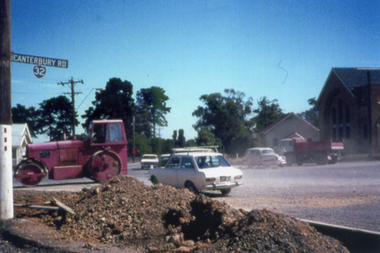 Whitehorse Historical Society Inc.
Photograph, Canterbury Road Vermont
Coloured print from a 110 slide of the construction of the dual highway in Canterbury Road and the Mitcham Road intersection. Note St Luke's Anglican Church on the right.canterbury road vermont, mitcham road vermont, st lukes anglican church vermont -
 Southern Sherbrooke Historical Society Inc.
Looking west down road to Selby from Hermons Corner
A herd of cows belonging to Ryan can be seen coming up the road by the Breen farm, Menzies Creek. Trees line the road. Hills are visible in the distance. -
 Ringwood and District Historical Society
Map, Department of Mines, Plan of area applied for under the mining leases regulations in the township of Ringwood between Maroondah Highway and Mt. Dandenong Road. Mining District of Castlemaine, County of Mornington, Parish of Ringwood T Area 58(A) 2 (R)15(P) Acres, Roods, Perches. 1934, 20-Feb-34
Map of the township of Ringwood with subdivisions between Maroondah Highway and Mt. Dandenong Road. the area applied for on lease No.8210 by E.G.Browne.Mining District of Castlemaine, County of Mornington, Parish of Ringwood T Area 58(A) 2 (R)15(P) Acres, Roods, Perches.Buff coloured sheet foolscap with black printing showing map of the township of Ringwood between Maroondah Highway and Mt. Dandenong Road. Mining District of Castlemaine, County of Mornington, Parish of Ringwood T Area 58(A) 2 (R)15(P) Acres, Roods, Perches +Additional Keywords: Browne E.G. -
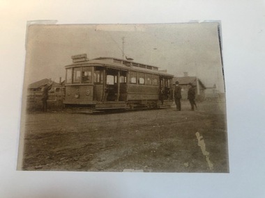 Melbourne Tram Museum
Photograph - Photograph Card, Keith Kings, Highfield Road terminus, Wattle Park, c2000?
Photograph - copied from an original print using a scanner and then printed on an A4 sheet of HTT 9 (could be 8) at the Highfield Road terminus, Wattle Park, 1925. The conductor is placing the trolley pole. A photocopied caption with the print notes as "The first tram along Riversdale Road to Highfield Road" See image i2 for further notes. Photo from Mrs Doris Turnbull of Essex Road.In pencil on the print "Keith Kings"trams, tramways, wattle park, highfield road, opening, conductors -
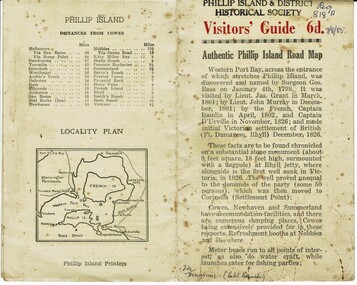 Phillip Island and District Historical Society Inc.
Booklet, Authentic Phillip Island Road Map, Pre 1960
Tourist brochure printed by the Phillip Island Printers pre 1960HistoricalSmall cream coloured brochure with details of accommodation, transport and animals. Inside is a map of the Island with numbered points of interest. There is also a plan of Cowes and drawings of animals.Visitors' Guide 6d Authentic Phillip Island Road Maptourist brochure, road map -
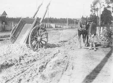 Ringwood and District Historical Society
Photograph, Wantirna Rd, Ringwood - early view of unmade road with horse and cart (undated)
Written on back of photograph, "Wantirna Road, from Ron Anderson". -
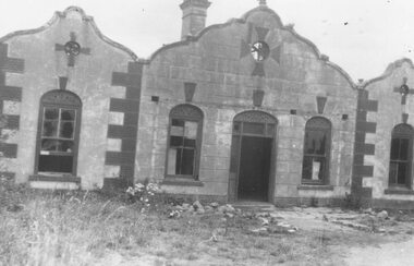
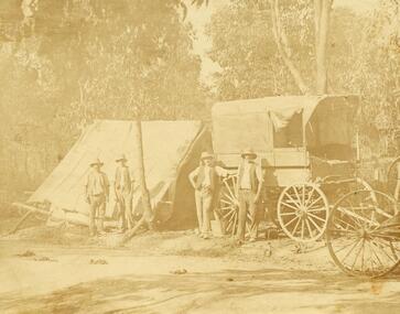 Ringwood and District Historical Society
Photograph, Road making in Ringwood (very old) (undated)
4 men in front of tent and wagon.Catalogue card reads, "Road making in Ringwood (very old)". -
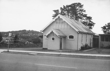 Ringwood and District Historical Society
Photograph, Ringwood Church of Christ Hall, Bedford Road, 1970
Written on backing sheet, "Church of Christ, Bedford Road, 1.11.70" -
 Ringwood and District Historical Society
Photograph, The Rest" tea rooms, Maroondah Highway, opposite Heatherdale Road
Black and white photograph of old brick building with scalloped roof-line. Decorative bricks in various places, particularly on top of windows and door.'The Rest' tea rooms, Maroondah Highway, opposite Heatherdale Road. -
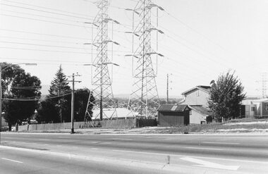 Ringwood and District Historical Society
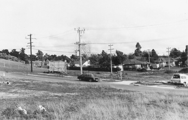
Photograph, Maroondah Highway West, Ringwood- 1969. Pylons near Heatherdale Road
Black and white photographWritten on back of photograph: "May 1969-Near Heatherdale Road."