Showing 2473 items
matching district views
-
 Eltham District Historical Society Inc
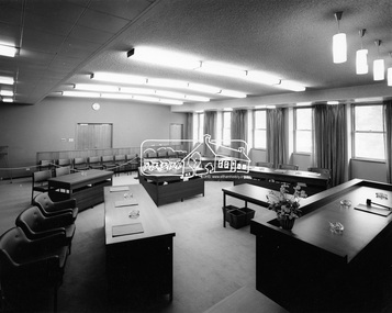
Photograph, Hugh Fisher, Eltham - View of Council Chamber, 1965
View of the Council Chamber in the brand new Eltham Shire Office opened in 1965.This photo forms part of a collection of photographs gathered by the Shire of Eltham for their centenary project book,"Pioneers and Painters: 100 years of the Shire of Eltham" by Alan Marshall (1971). The collection of over 500 images is held in partnership between Eltham District Historical Society and Yarra Plenty Regional Library (Eltham Library) and is now formally known as the 'The Shire of Eltham Pioneers Photograph Collection.' It is significant in being the first community sourced collection representing the places and people of the Shire's first one hundred years.Digital imagesepp, shire of eltham pioneers photograph collection, eltham, eltham shire office, council chamber -
 Eltham District Historical Society Inc
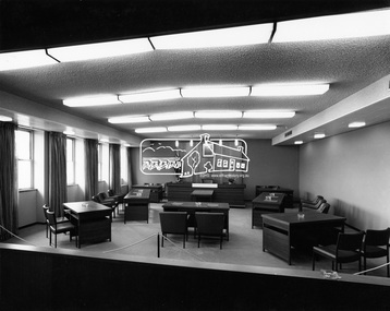
Photograph, Hugh Fisher, Eltham - View of Council Chamber, c.1965, 1965
View of Council Chamber in brand new Eltham Shire Offices 1965This photo forms part of a collection of photographs gathered by the Shire of Eltham for their centenary project book, "Pioneers and Painters: 100 years of the Shire of Eltham" by Alan Marshall (1971). The collection of over 500 images is held in partnership between Eltham District Historical Society and Yarra Plenty Regional Library (Eltham Library) and is now formally known as 'The Shire of Eltham Pioneers Photograph Collection.' It is significant in being the first community sourced collection representing the places and people of the Shire's first one hundred years.Digital imagesepp, shire of eltham pioneers photograph collection, eltham, eltham shire office, council chamber -
 Eltham District Historical Society Inc
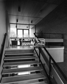
Photograph, Hugh Fisher, Eltham - Interior staircase in Shire Office leading to Reception area, c.1965, 1965
View of interior staircase leading to the reception area in the new Shire of Eltham Office at 856 Main Road, ElthamThis photo forms part of a collection of photographs gathered by the Shire of Eltham for their centenary project book, "Pioneers and Painters: 100 years of the Shire of Eltham" by Alan Marshall (1971). The collection of over 500 images is held in partnership between Eltham District Historical Society and Yarra Plenty Regional Library (Eltham Library) and is now formally known as 'The Shire of Eltham Pioneers Photograph Collection.' It is significant in being the first community sourced collection representing the places and people of the Shire's first one hundred years.Digital imagesepp, shire of eltham pioneers photograph collection, eltham, eltham shire office -
 Eltham District Historical Society Inc
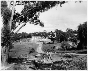
Photograph, Shire of Eltham, Petrie Park, Montmorency, November 1966
View of Petrie Park with children's playground in the foreground, sports oval to the left. Montmorency Scouts and Montmorency Bowling Club in the background. Originally identified as: Henry Petrie Community Centre.This photo forms part of a collection of photographs gathered by the Shire of Eltham for their centenary project book, "Pioneers and Painters: 100 years of the Shire of Eltham" by Alan Marshall (1971). The collection of over 500 images is held in partnership between Eltham District Historical Society and Yarra Plenty Regional Library (Eltham Library) and is now formally known as 'The Shire of Eltham Pioneers Photograph Collection.' It is significant in being the first community sourced collection representing the places and people of the Shire's first one hundred years.Digital imagesepp, shire of eltham pioneers photograph collection, montmorency, petrie park, montmorency bowling club, montmorency scouts -
 Eltham District Historical Society Inc
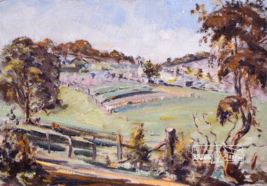
Photograph, Bird family Orchard, Pitt Street, Eltham, c.1980s
View looking northeast from near junction of Wattle Grove and Mount Pleasant Road across to Eucalyptus Road on right and Pitt Street at top. Early pioneer, George Bird Snr. arrived from England in 1852 and lived with his uncle, George Stebbing. He worked for him as bricklayer's assistant in building, among others, the Anglican and Methodist Churches in Eltham. In 1862 he purchased land in the east end of Pitt Street bounded by Eucalyptus Road and Wattle Grove and established a mixed farm and orchard. His son, Arthur Bird succeeded him and also worked on this orchard which then passed to Arthur's son, Harold Bird OAM, where Harold and Yvonne Bird lived in the family home till the mid 2000s A4 size photographic print reproduction of a paintingaos6, wattle grove, pitt street, arthur bird, bird family orchard, eucalyptus road, george bird, harold bird, yvonne bird, eltham -
 Eltham District Historical Society Inc
Photograph, Bird family Orchard, Pitt Street, Eltham, c.1980s, 1980s
View looking northeast from near junction of Wattle Grove and Mount Pleasant Road across to Eucalyptus Road on right and Pitt Street at top. Early pioneer, George Bird Snr. arrived from England in 1852 and lived with his uncle, George Stebbing. He worked for him as bricklayer's assistant in building, among others, the Anglican and Methodist Churches in Eltham. In 1862 he purchased land in the east end of Pitt Street bounded by Eucalyptus Road and Wattle Grove and established a mixed farm and orchard. His son, Arthur Bird succeeded him and also worked on this orchard which then passed to Arthur's son, Harold Bird OAM, where Harold and Yvonne Bird lived in the family home till the mid 2000s A4 size photographic printaos6, wattle grove, pitt street, arthur bird, bird family orchard, eucalyptus road, george bird, harold bird, yvonne bird, eltham -
 Eltham District Historical Society Inc
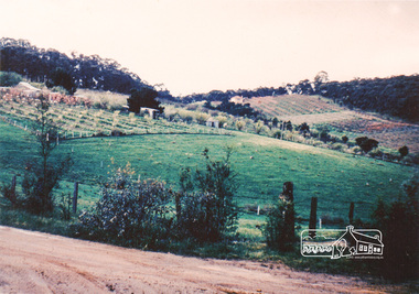
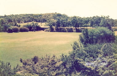
Photograph, View looking southwest from near Manatunga Circuit across the Diamond Valley United Soccer Club field, Greensborough, c.1986, 1986c
Greensborough Plaza at far left. Railway line running horizontally across centre of picture. Three colour photographs and one digital panorama created from two of the three images. Colour photographs originally located in a magnetic style album titled 'Greensborough Bypass 1990s 5' suffering significant degradation. No information contained in album or on reverse of photos except where noted. Relocated to archival photosafe storage.manatunga circuit, greensborough plaza, diamond valley united soccer club, greensborough -
 Eltham District Historical Society Inc
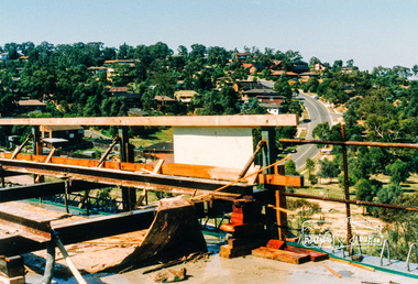
Photograph, View looking northwest along Plenty River Drive, Greensborough from outside No. 64, c.1986, 1986c
Shows the eastern bridge of the Greensborough Bypass under construction. Colour photograph originally located in a magnetic style album titled 'Greensborough Bypass 1990s 5' suffering significant degradation. No information contained in album or on reverse of photos except where noted. Relocated to archival photosafe storage.greensborough bypass, road construction, plenty river drive, greensborough -
 Eltham District Historical Society Inc
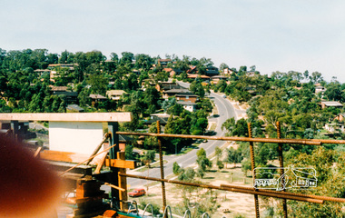
Photograph, Southeast view from new bridge over Plenty River looking along Plenty River Drive, Greensborough Bypass construction, c.1986, 1986c
Mura Close and Tangari Court visible on left, Warriparri Crescent on right of Plenty River Drive.Colour photograph originally located in a magnetic style album titled 'Greensborough Bypass 1990s 5' suffering significant degradation. No information contained in album or on reverse of photos except where noted. Relocated to archival photosafe storage.greensborough bypass, road construction, greensborough, mura close, tangari crescent, plenty river drive, warriparri crescent -
 Eltham District Historical Society Inc
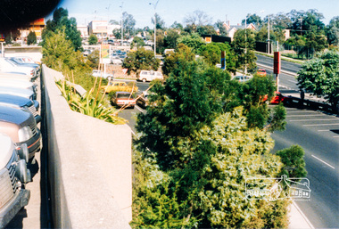
Photograph, View from Greensborough Plaza just north of Lorimer Street looking south to Grimshaw Street, c.1986, 1986c
Colour photograph originally located in a magnetic style album titled 'Greensborough Bypass 1990s 5' suffering significant degradation. No information contained in album or on reverse of photos except where noted. Relocated to archival photosafe storage.greensborough bypass, road construction, greensborough, greensborough plaza, lorimer street, grimshaw street -
 Eltham District Historical Society Inc
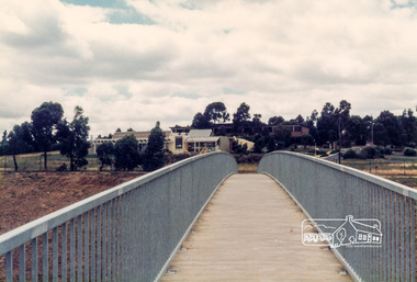
Photograph, View of Diamond Valley Library from the new pedestrian overpass; Greensborough Bypass construction, c.1986, 1986c
Colour photograph originally located in a magnetic style album titled 'Greensborough Bypass 1990s 5' suffering significant degradation. No information contained in album or on reverse of photos except where noted. Relocated to archival photosafe storage.greensborough bypass, road construction, greensborough, diamond valley library -
 Eltham District Historical Society Inc
Photograph, View of the new pedestrian overpass from the carpark at Diamond Valley; Greensborough Bypass construction, c.1986, 1986c
Colour photograph originally located in a magnetic style album titled 'Greensborough Bypass 1990s 5' suffering significant degradation. No information contained in album or on reverse of photos except where noted. Relocated to archival photosafe storage.greensborough bypass, road construction, greensborough, diamond valley library -
 Eltham District Historical Society Inc
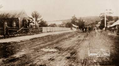
Photograph, View of 'Willis Vale', Greensborough, 1906, 1906c
'Willis Vale' home of the Partington family is shown in this photograph as well as the area now known as Partington's Flat. The area was owned and farmed by the Partington family from the 1870s. Willis Vale was destroyed by fire in the 1960sBlack and white photograph copy originally located in a magnetic style album titled 'Greensborough Bypass 1990s 5' suffering significant degradation. No information contained in album or on reverse of photos except where noted. Relocated to archival photosafe storage.greensborough, partingtons flat, partington family, willis vale -
 Eltham District Historical Society Inc
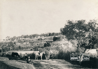
Photograph, Main Street, Greensborough, c.1900, 1900c
Shows view looking up Main Street, Greensborough across the Plenty River BridgePhotograph copy originally located in a magnetic style album titled 'Greensborough Bypass 1990s 5' suffering significant degradation. No information contained in album or on reverse of photos except where noted. Relocated to archival photosafe storage.greensborough, main street, plenty river bridge -
 Eltham District Historical Society Inc
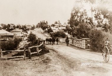
Photograph, Main Street, Greensborough, c.1910, 1910c
Early view of Main Street Greensborough showing the mainly residential nature of the buildings. Photographs from the collection of Peter Blackbourn, a descendant of the Chapman Stock family.Photograph copy originally located in a magnetic style album titled 'Greensborough Bypass 1990s 5' suffering significant degradation. No information contained in album or on reverse of photos except where noted. Relocated to archival photosafe storage.greensborough, main street -
 Eltham District Historical Society Inc
Photograph, Eltham North Primary School viewed from Glen Park Road, Eltham North, c.1983, 1983c
Originally contained in a 'magnetic' photo album believed to have been donated by Mr Eric Stephenson, Jingalong, 110 Ryans Road, Eltham, Vic. 3095; relocated to archival safe storage.Colour photographeltham north, eltham north primary school, glen park road -
 Eltham District Historical Society Inc
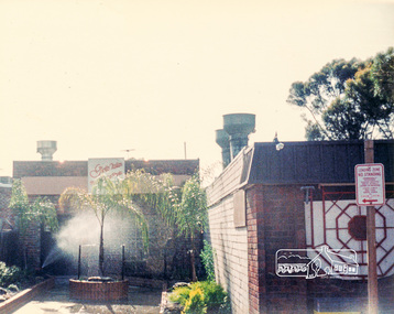
Photograph, Rear view of Grand Garden Chinese Restaurant, cnr Main Road and Luck Street, and Pizza Pasta Restaurant, Commercial Place, Eltham, late 1970s, 1970s
Colour photographgrand garden chinese restaurant, luck street, main road, restaurants, commercial place, pizza pasta restaurant -
 Eltham District Historical Society Inc
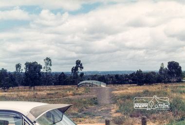
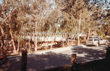
Photograph, Eltham Rugby Union Football Oval, Shire of Eltham, 1985, 1985
Viewed from the Community Centre, Bridge Street in background. Shire of Eltham Archives Series 13, Photograph Album, 1985. Originally contained in a 2-ring PVC binder and document sleevesColour photographseries 13, shire of eltham archives, bridge street, eltham rugby football club -
 Eltham District Historical Society Inc
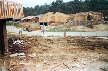
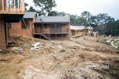
Photograph, Building development, 1985, 1985
Viewing from right Nos. 2 and 4 Long Valley Way, Eltham. Shire of Eltham Archives Series 13, Photograph Album, 1985. Originally contained in a 2-ring PVC binder and document sleevesColour photographseries 13, shire of eltham archives, construction, eltham, long valley way, houses -
 Eltham District Historical Society Inc
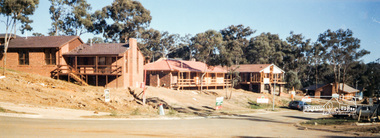
Photograph, Building development, 1985, 1985
Viewing from left Nos. 3, 5, 7 and 9 Long Valley Way, Eltham. Fiona Court runs off between 7 and 9. Shire of Eltham Archives Series 13, Photograph Album, 1985. Originally contained in a 2-ring PVC binder and document sleevesColour photographseries 13, shire of eltham archives, construction, eltham, long valley way, houses -
 Eltham District Historical Society Inc
Photograph, Williamstown Excursion, 21 March 1982, 21/03/1982
[from EDHS Newsletter No. 24, May 1982:] WILLIAMSTOWN TRIP The trip to Williamstown on 21st March was highly successful from any point of view, The one disappointment was that we were so successful in filling the bus that a few people with late bookings could not go. We apologise to those that missed out. The Williamstown Historical ........ us their excellent museum, arranged afternoon tea and provided a well informed guide for a trip around the sights of their city. Their obvious enthusiasm for informing visitors about Williamstown contributed in no small way to the enjoyment of the day.Twelve colour photographsactivities, williamstown, williamstown historical society -
 Eltham District Historical Society Inc
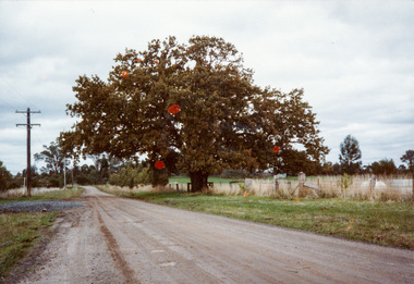
Photograph, Donaldson Oak, Donaldson Road, Kangaroo Ground, 1986, 1986
Used for the Society's Banner project. [note written by Joy Ness, "View Hill", Kangaroo Ground, 11 June 1986:] In 1878 while on a trip to Scotland and England, John Donaldson visited Windsor Castle Park, where he collected some acorns which he brought back to Australia, to his property, "Kangaroo Hall" at Kangaroo Ground. He and his son John Anstruther Davidson Donaldson, who was then 10 years old, planted one near the present Donaldson's Lane, in 1878. This is now a very fine tree, 108 years old. This information comes from Miss Victoria Donaldson, daughter of John Anstruther Davidson Donaldson. Miss Donaldson suggests that Wippell's Oak at Kangaroo Ground may also have been grown from one of the same Windsor Park acorns.Colour photographactivities, banner project, donaldsons oak, john anstruther davidson donaldson, kangaroo ground, significant trees, william donaldson -
 Eltham District Historical Society Inc
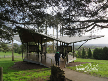
Photograph, Liz Pidgeon, Moor-Rul Viewing Platform, 10 August 2016
The Moor-Rul Viewing Platform, part of the Kangaroo Ground War Memorial Park opened in April 2007. Eight double-sided interpretation panels on the Moor-rul viewing platform highlight the area's Aboriginal and European history of the area and also details of local geology, flora and fauna. These panels feature high quality graphic design and professionally written text. The subjects covered are: ''Womin Je Ka" Welcome The Kulin Nation Singing, Dancing, Ceremony, Celebration This Country, My Home The Highland Taken Auld Lang Syne "Same Land Different Views" Working the Land Food from the Earth or "Earth's Harvest" Lest We Forget, "And with the going down of the Sun .... (3 panels) This Black Earth Those other indigenous inhabitants - Kangaroo Ground's Wildlife Silent Witnesses - Kangaroo Ground's White Manna Gums Belonging A Place of Reverence and A Tower of Strength Souce: EDHS Newsletter No 173 March 2007. As part of a program to acknowledge the Anzac Centenary Nillumbik Shire Council partnered with Yarra Plenty Regional Library to provide a bus tour with commentary of local sites of significance: Shire of Nillumbik World War One Memorials tour, 10 August 2016. These included Eltham township, the Shire of Eltham War Memorial at Kangaroo Ground, Christmas Hills war memorial, Hurstbridge memorial recreation park and finshed at Eltham Library to view the Writing the War exhibtion at Eltham Library Community Gallery.Born Digitalshire of nillumbik, moor-rul viewing platform, kangaroo ground, memorial park -
 Eltham District Historical Society Inc
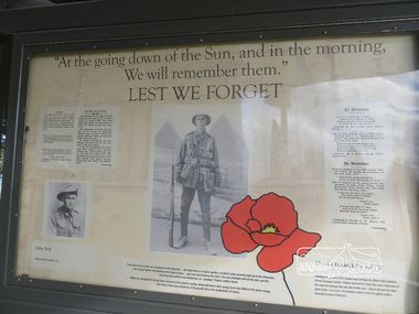
Photograph, Liz Pidgeon, Moor-Rul Viewing Platform Panel: Lest We Forget, 10 August 2016
Includes photograph of WW1 local enlistment John Bell. The Moor-Rul Viewing Platform, part of the Kangaroo Ground War Memorial Park opened in April 2007. Eight double-sided interpretation panels on the Moor-rul viewing platform highlight the area's Aboriginal and European history of the area and also details of local geology, flora and fauna. These panels feature high quality graphic design and professionally written text. The subjects covered are: ''Womin Je Ka" Welcome The Kulin Nation Singing, Dancing, Ceremony, Celebration This Country, My Home The Highland Taken Auld Lang Syne "Same Land Different Views" Working the Land Food from the Earth or "Earth's Harvest" Lest We Forget, "And with the going down of the Sun .... (3 panels) This Black Earth Those other indigenous inhabitants - Kangaroo Ground's Wildlife Silent Witnesses - Kangaroo Ground's White Manna Gums Belonging A Place of Reverence and A Tower of Strength Souce: EDHS Newsletter No 173 March 2007. As part of a program to acknowledge the Anzac Centenary Nillumbik Shire Council partnered with Yarra Plenty Regional Library to provide a bus tour with commentary of local sites of significance: Shire of Nillumbik World War One Memorials tour, 10 August 2016. These included Eltham township, the Shire of Eltham War Memorial at Kangaroo Ground, Christmas Hills war memorial, Hurstbridge memorial recreation park and finshed at Eltham Library to view the Writing the War exhibtion at Eltham Library Community Gallery.Born Digitalworld war 1, war memorials, shire of nillumbik, moor-rul viewing platform, interpretation panel, interpretative signage, lest we forget, shire of eltham war memorial, john bell, display panel -
 Eltham District Historical Society Inc
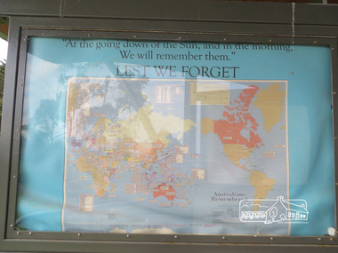
Photograph, Liz Pidgeon, Moor-Rul Viewing Platform Panel: Lest We Forget, 10 August 2016
Coloured map of the world on blue including the words for the "Lest We Forget" lament. The Moor-Rul Viewing Platform, part of the Kangaroo Ground War Memorial Park opened in April 2007. Eight double-sided interpretation panels on the Moor-rul viewing platform highlight the area's Aboriginal and European history of the area and also details of local geology, flora and fauna. These panels feature high quality graphic design and professionally written text. The subjects covered are: ''Womin Je Ka" Welcome The Kulin Nation Singing, Dancing, Ceremony, Celebration This Country, My Home The Highland Taken Auld Lang Syne "Same Land Different Views" Working the Land Food from the Earth or "Earth's Harvest" Lest We Forget, "And with the going down of the Sun .... (3 panels) This Black Earth Those other indigenous inhabitants - Kangaroo Ground's Wildlife Silent Witnesses - Kangaroo Ground's White Manna Gums Belonging A Place of Reverence and A Tower of Strength Souce: EDHS Newsletter No 173 March 2007. As part of a program to acknowledge the Anzac Centenary Nillumbik Shire Council partnered with Yarra Plenty Regional Library to provide a bus tour with commentary of local sites of significance: Shire of Nillumbik World War One Memorials tour, 10 August 2016. These included Eltham township, the Shire of Eltham War Memorial at Kangaroo Ground, Christmas Hills war memorial, Hurstbridge memorial recreation park and finshed at Eltham Library to view the Writing the War exhibtion at Eltham Library Community Gallery. Born Digitalworld war 1, war memorials, shire of nillumbik, moor-rul viewing platform, kangaroo ground, shire of eltham war memorial, interpretative signage, interpretation panel, map, display panel -
 Eltham District Historical Society Inc
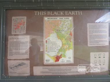
Photograph, Liz Pidgeon, Moor-Rul Viewing Platform Panel: This Black Earth, 10 August 2016
"Melbourne soil types" The Moor-Rul Viewing Platform, part of the Kangaroo Ground War Memorial Park opened in April 2007. Eight double-sided interpretation panels on the Moor-rul viewing platform highlight the area's Aboriginal and European history of the area and also details of local geology, flora and fauna. These panels feature high quality graphic design and professionally written text. The subjects covered are: ''Womin Je Ka" Welcome The Kulin Nation Singing, Dancing, Ceremony, Celebration This Country, My Home The Highland Taken Auld Lang Syne "Same Land Different Views" Working the Land Food from the Earth or "Earth's Harvest" Lest We Forget, "And with the going down of the Sun .... (3 panels) This Black Earth Those other indigenous inhabitants - Kangaroo Ground's Wildlife Silent Witnesses - Kangaroo Ground's White Manna Gums Belonging A Place of Reverence and A Tower of Strength Souce: EDHS Newsletter No 173 March 2007. As part of a program to acknowledge the Anzac Centenary Nillumbik Shire Council partnered with Yarra Plenty Regional Library to provide a bus tour with commentary of local sites of significance: Shire of Nillumbik World War One Memorials tour, 10 August 2016. These included Eltham township, the Shire of Eltham War Memorial at Kangaroo Ground, Christmas Hills war memorial, Hurstbridge memorial recreation park and finshed at Eltham Library to view the Writing the War exhibtion at Eltham Library Community Gallery.Born Digitalshire of nillumbik, moor-rul viewing platform, interpretative signage, interpretation panel, display panel -
 Eltham District Historical Society Inc
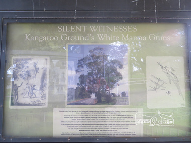
Photograph, Liz Pidgeon, Moor-Rul Viewing Platform Panel: Silent Witnesses Kangarooo Ground's White Manna Gums, 10 August 2016
The Moor-Rul Viewing Platform, part of the Kangaroo Ground War Memorial Park opened in April 2007. Eight double-sided interpretation panels on the Moor-rul viewing platform highlight the area's Aboriginal and European history of the area and also details of local geology, flora and fauna. These panels feature high quality graphic design and professionally written text. The subjects covered are: ''Womin Je Ka" Welcome The Kulin Nation Singing, Dancing, Ceremony, Celebration This Country, My Home The Highland Taken Auld Lang Syne "Same Land Different Views" Working the Land Food from the Earth or "Earth's Harvest" Lest We Forget, "And with the going down of the Sun .... (3 panels) This Black Earth Those other indigenous inhabitants - Kangaroo Ground's Wildlife Silent Witnesses - Kangaroo Ground's White Manna Gums Belonging A Place of Reverence and A Tower of Strength Souce: EDHS Newsletter No 173 March 2007. As part of a program to acknowledge the Anzac Centenary Nillumbik Shire Council partnered with Yarra Plenty Regional Library to provide a bus tour with commentary of local sites of significance: Shire of Nillumbik World War One Memorials tour, 10 August 2016. These included Eltham township, the Shire of Eltham War Memorial at Kangaroo Ground, Christmas Hills war memorial, Hurstbridge memorial recreation park and finshed at Eltham Library to view the Writing the War exhibtion at Eltham Library Community Gallery. Born Digitalshire of nillumbik, moor-rul viewing platform, kangaroo ground, manna gum, display panel -
 Eltham District Historical Society Inc
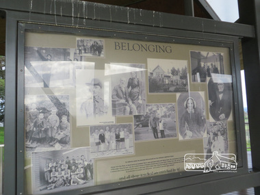
Photograph, Liz Pidgeon, Moor-Rul Viewing Platform Panel: Belonging, 10 August 2016
Collage of black and white historical photographs of people. The Moor-Rul Viewing Platform, part of the Kangaroo Ground War Memorial Park opened in April 2007. Eight double-sided interpretation panels on the Moor-rul viewing platform highlight the area's Aboriginal and European history of the area and also details of local geology, flora and fauna. These panels feature high quality graphic design and professionally written text. The subjects covered are: ''Womin Je Ka" Welcome The Kulin Nation Singing, Dancing, Ceremony, Celebration This Country, My Home The Highland Taken Auld Lang Syne "Same Land Different Views" Working the Land Food from the Earth or "Earth's Harvest" Lest We Forget, "And with the going down of the Sun .... (3 panels) This Black Earth Those other indigenous inhabitants - Kangaroo Ground's Wildlife Silent Witnesses - Kangaroo Ground's White Manna Gums Belonging A Place of Reverence and A Tower of Strength Souce: EDHS Newsletter No 173 March 2007. As part of a program to acknowledge the Anzac Centenary Nillumbik Shire Council partnered with Yarra Plenty Regional Library to provide a bus tour with commentary of local sites of significance: Shire of Nillumbik World War One Memorials tour, 10 August 2016. These included Eltham township, the Shire of Eltham War Memorial at Kangaroo Ground, Christmas Hills war memorial, Hurstbridge memorial recreation park and finshed at Eltham Library to view the Writing the War exhibtion at Eltham Library Community Gallery.Born Digitalshire of nillumbik, moor-rul viewing platform, kangaroo ground, interpretative signage, interpretation panel, display panel