Showing 123994 items
matching main-road
-
 Federation University Historical Collection
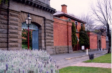
Photograph - Photograph - Colour, Former Ballarat Gaol Gates and Warden's Quarters, 2001, 1991
The Ballarat Gaol operated between 1862 and 1965. The complex was based on a central hall from which radiated wings of cells. This meant one guard could stand in the centre of the hall and see all the cells. Most of the gaol was demolished to allow the School of MInes Ballarat to expand. The remaining structures at the site include the main gate, the Warden's Residence, shown in the photo, and the Governor's Residence. These buildings are now used by Federation University. The Warden's Residence is home to the Australian Centre for Research into Injury in Sports and its Prevention.Colour photograph of the main gate of the former Ballarat Gaol and the Warden's Quarters. The gate features a beautifully executed arch keystone of basalt and appears to be cut from one single block of stone. The two storey Warden's Quarters are to the right of the gates.ballarat gaol, lydiard street south, ballarat school of mines, cells, guard, warden's residence, governor's residence, federation university -
 Melbourne Tram Museum
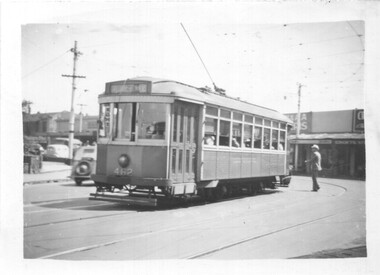
Photograph - X1 462 Nicholson St Footscray
The photograph of X1 class tram No. 462 in Nicholson St Footscray on its way to Williamstown Road. About the pass over the railway line. Photographer and date unknown.Yields information the MMTB X1 class tram No. 462.Black and white photograph with notes on the rear.In pencil "MMTB 462 to Williamstown Road near Rly Stn, Footscray. Tram about to cross over the Melbourne to Adelaide line". tramcars, tramways, x1 class, tram 462, footscray, nicholson st -
 Greensborough Historical Society
Memoir, Recollections by Vera Lay, 1955o
Vera Lay worked in the building known as Marble Hall (situated on the corner of Carter Street (now Para Road) and Main Street. She recalls many of the people and places that made up Main Street Greensborough in the 1950s.A primary source recollection of Greensborough in the mid-20th century.2 typed pages, illustration.vera lay, marble hall, main street greensborough, june hall -
 Eltham District Historical Society Inc
Film - Video (DVD), Frank Stokes, Stokes Family, 1950-1977
Various family scenes taken from outside the family home on the southeast corner of the intersection of Nyora Road and Pitt Street with Eucalyptus Road. Also, scenes of the Stokes Orchard and equipment used, construction of water reservoir at the end of Nyora Road near Reynolds Road and Diosma Road as well as early stages of the Stokes Orchard housing development. Frank Stokes worked as a qualified accountant at Kennons leather factory in Burnley, while living at 1 Thomas Street, Mitcham. He suffered from migraines and wanted to go back to the land (he had previously worked on farms and orchards since coming to Australia in 1926 both in WA and Vic.). He first travelled to the district by train in July 1942 to find land with the intention to establish an orchard. By chance he met Arthur Bird of Bird Orchard (bounded by Pitt Street, Eucalyptus Road and Wattle Grove) and they got talking over their common interest. Arthur put Frank up for the night and pointed out the land, 158 acres- Taylor Estate- £900, part of Crown Allotment 15, Section 5, Parish of Nillumbik (CA15) somewhat diagonally opposite Bird Orchard. He applied through the Riverina Agency to purchase the land who in turn had to get permission from Canberra to sell as there was a new government regulation banning land sales except for immediate production. He obtained a loan on his Mitcham house of £600 @ 5% and paid £450 deposit with quarterly payments of £15 over 5 years. The title to the property was issued May 15, 1946. He was helped and advised by Arthur Bird who farmed the neighbouring orchard. Early 1943 he took possession and would catch the train out to Eltham on Fridays after work and began building a hut for shelter and to lock up tools. He was able to pay a neighbour (Hawkins) to help with clearing and fencing 25 acres and with a horse and single furrowed plow, planted approximately 2,500 fruit trees - cherries, peaches, plums, almonds, pears, apricots and lemons as well as a few apples and oranges; a massive job. A huge problem was hares and rabbits eating all the new buds off the tiny trees. As well as laying poison he painted the trees with a mixture of cow manure and lime. Often working by moonlight. It was extremely difficult to get wire and wire netting because of the war but after much effort he obtained a permit from the Agricultural Department for supplies in March 1944. In February 1945 he applied for a permit to build a “packing shed” as no house building allowed. It was to be 33 feet x 21 feet and cost £312. Constructed mostly from second-hand materials, which was hard to obtain, especially iron for roofing. Frank finished work at Kennons October 31, 1945, and in March 1946 he sold the Mitcham house for £1230 plus £170 for furniture. The family of five then moved into a very unfinished at Eltham, which was a struggle to weatherproof. Eventually rooms were divided off and lined with hessian bags and whitewashed. Their income was firewood (cut and sold), selling rockery stones and cut sweet bursaria. (It was discovered during the 1940s that Bursaria contained the sunscreen compound Aesculin. The RAAF utilised this compound from Bursaria during WW2 for pilots and gunners.) The orchard’s first fruit sale was a 1/2 case of Le Vanq peaches in December 1947 - 8 shillings. In 1956 plans for house were drawn and Glen Iris bricks purchased (1956 Olympic Rings variant). The building of the house commenced in 1957 - 12 feet of original packing shed removed – and was completed in 1959. Water was connected from newly built pressure storage on the property at the end of 1959 and the electricity connection for the first time at 3pm on April 29, 1960. In the mid-1970s the Shire of Eltham divided the orchard up into numerous rate-able parcel lots, which became unaffordable for Frank. Consequently, Stokes Orchard was turned into a housing development by Macquarie Builders and marketed as the Stokes Orchard Estate in two stages; Stage 1 encompassing Scarlet Ash Court, Ironbark Close and Peppermint Grove bounded by Nyora and Eucalyptus roads c.1976 and Stage 2 encompassing Stokes Place, Orchard Way, The Crest and The Lookout bound by Nyora and Diosma roads c.1979. The development of Orchard Way, The Crest and The Lookout did not proceed as planned due to the lack of the sewer along Diosma Road and so many of the proposed lots were incorporated into five-acre parcels instead. With the arrival of the sewer along Diosma Road many years later, most of these five-acre parcels have since been subdivided many times.Representative of the orchard growing areas of ElthamMP4 00:24:39; 426MB Digital file only - Digitised by EDHS from a DVD copy on loan from Beryl Bradbury (nee Stokes), daughter of Frank Stokes. 24 min duration compilation of home movie Super 8mm film shot by Frank Stokes brother-in-law.beryl bradbury (nee stokes) collection, frank stokes, nyora road, stokes orchard, stokes orchard estate, stokes place, video recording -
 Eltham District Historical Society Inc
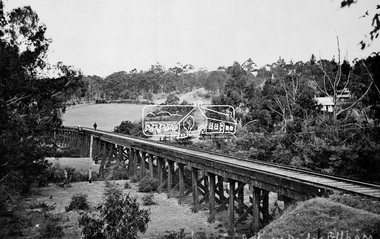
Negative - Photograph, Tom Prior, Railway Trestle Bridge over the Diamond Creek, Eltham, Vic, c.1910
Railway Trestle Bridge over the Diamond Creek, Eltham, c.1910 - looking towards Main Road (left to right) and Henry Street (centre). Built in 1901, the railway line was electrified in 1923. Photo was taken prior to 1912 and the relocation of the new St Mary’s Catholic Church on Henry Street near Main Road (or Maria Street). The church site was relocated c.1912 from further south along Main Road (near Wingrove Cottage) to be more central to the congregation following the shifting of the township away from Little Eltham and closer to the railway station. It was subsequently destroyed by fire in 1961.This photo forms part of a collection of photographs gathered by the Shire of Eltham for their centenary project book,"Pioneers and Painters: 100 years of the Shire of Eltham" by Alan Marshall (1971). The collection of over 500 images is held in partnership between Eltham District Historical Society and Yarra Plenty Regional Library (Eltham Library) and is now formally known as the 'The Shire of Eltham Pioneers Photograph Collection.' It is significant in being the first community sourced collection representing the places and people of the Shire's first one hundred years. The Reynolds family were early settlers in Research. The Reynolds/ Prior collection of photographs were taken by Tom Prior, the maternal uncle of Ivy Reynolds, around 1900 and the 60 photos in the album give a fine overview of many of the landmarks of Research and Eltham over 100 years ago. lvy lived in the family home for many years at 106 Thompson Cres Research. Ivy's father, Ernst Richard Reynolds and grandfather, Richard Reynolds, lived at the same address. Ivy's father Richard worked for Mr. Trail on his property in Research. Reynolds Road is named after the family. Mr Tom Prior (wife Eva) worked at the Melbourne zoo. He was very innovative and made his own camera, using the black cloth hood to exclude the light. The photographs are a reminder of the rural nature of Research and Eltham and its rich heritage.Digital image 4 x 5 inch B&W Negshire of eltham pioneers photograph collection, bridge, diamond creek (creek), eltham, eltham railway trestle bridge, henry street, main road, reynolds prior collection, trestle bridge -
 Tarnagulla History Archive
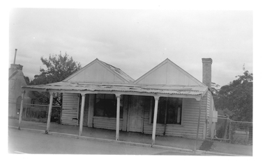
Photograph of double-fronted weatherboard shopfront, Tarnagulla, Late 1960s
Murray Comrie Collection. Building is on Commercial Road and in 2019 is a private residence. History to be confirmed.Monochrome photograph depicting a white double-fronted weatherboard shopfront, with six-post verandah, formerly located at 107 Commercial Road in Tarnagulla. Building has since been demolished.tarnagulla, buildings -
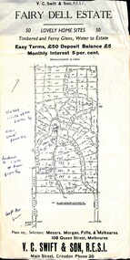 Ringwood and District Historical Society
Flyer, Residential Land Sale Sub-division - Fairy Dell Estate, Warranwood, Vic. - circa 1950s
Land sale advertisement for 50 home sites with map of Sub-division showing layout of streets and allotments, summary of local features and services and terms of sale, and copy of sectional map of Crown Allotments 20 & 21B Parish of Warrandyte also showing layout of Sub-division.Subdivision includes Grandview Grove (later Bemboka Road), Merrill Crescent and Kerry Road, Warranwood. Estate Agents - V.C. Swift & Son R.E.S.I., Main Street, Croydon, Phone 20. Solicitors - Morgan, Fyffe & Mulkearns, 108 Queen Street, Melbourne. Handwritten 1970s real estate price notations for some blocks. -
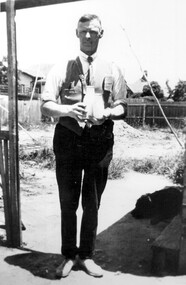 Surrey Hills Historical Society Collection
Photograph, Alfred Charles Bignell, dairyman of Balwyn and surrounding areas
The man is Alfred Charles Bignell (1890-1965), dairyman of 6 Parring Road, Balwyn. Alf served in WW1 (SERN 781); enlisted at Apollo Bay; member of 4th Light Horse Regiment, 3rd Reinforcement; spent time on Gallipoli and in France and England. Alf is remembered, as Alfred Bignell, in the Ballarat Avenue of Honour as he spent time in the area with the Williams family. He married in England and after the war briefly returned to Apollo Bay before initially settling in Surrey Hills, where he worked for dairyman Canterbury Oliver Towt. He went on to buy the dairy at 6 Parring Road, Balwyn from Charles W Woolfe. He named it Lone Pine Dairy and the family continued to operate it after his death until c2005 when it was sold. Buried in Box Hill Cemetery.Black & white photo of a man standing under a veranda or similar. He is holding a cream and a milk bottle. There is a dog at his feet and rough ground in the background.dairyman, lone pine dairy, alfred charles bignell, parring road, balwyn, alfred charles williams, charles w woolfe -
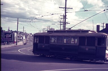 Ballarat Tramway Museum
Slide - 35mm slide/s - set of 2, Dave Simpson, late 1960's early 1970's
Yields information about the intersection of Main Road and Barkly St Mt PleasantSet of two 35mm slides - Anscochrome white plastic mounts of No. 13 turning from Main Road into Barkly St with the destination of Mt Pleasant. .2 - the tram has a Twin Lakes on the rear of the tram with a Morris motor car at the rear of the tram. In the background are roadside advertisements for HBA and Taubman's paints.tramways, trams, barkly st, main road, mt pleasant, tram 13 -
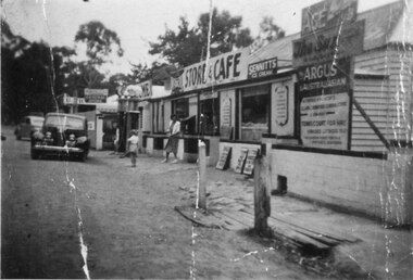 Halls Gap & Grampians Historical Society
Photograph - B/W
See 'Bridging the Gap' p65. Grampians Road Halls Gap.Group of shops with numerous advertising signs. A woman is leaving a shop, a young girl is standing in front of her. Two cars are parked in front of shops. Gravel road. Large gum trees in the background.buildings, shops -
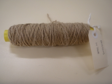
 National Wool Museum
Bobbin
A bobbin used at the Brintons Carpets factory at Fellmongers Road, Breakwater.W7203 Page 1 of a history of Brintons Carpets. Page 2 of a history of Brintons Carpets. A list of catalogues/items in the Brintons Collection donated after closure of Fellmongers Road factory in July 2008.textile machinery weaving, brintons australia pty ltd brintons pty ltd (geelong), carpet, geelong, victoria, textile machinery, weaving -
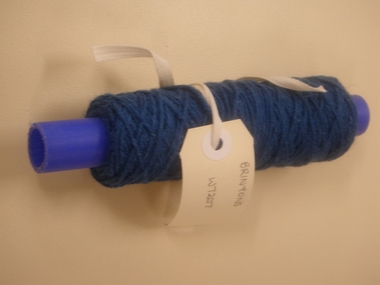
 National Wool Museum
Bobbin
A bobbin used at the Brintons Carpets factory at Fellmongers Road, Breakwater.W7205 Page 1 of a history of Brintons Carpets. Page 2 of a history of Brintons Carpets. A list of catalogues/items in the Brintons Collection donated after closure of Fellmongers Road factory in July 2008.textile machinery weaving, brintons australia pty ltd brintons pty ltd (geelong), carpet, geelong, victoria, textile machinery, weaving -
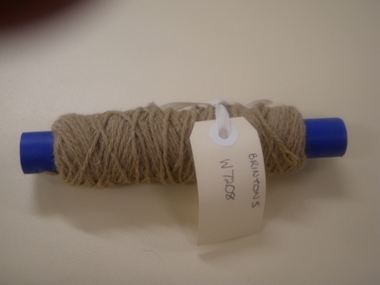
 National Wool Museum
Bobbin
A bobbin used at the Brintons Carpets factory at Fellmongers Road, Breakwater.W7206 Page 1 of a history of Brintons Carpets. Page 2 of a history of Brintons Carpets. A list of catalogues/items in the Brintons Collection donated after closure of Fellmongers Road factory in July 2008.weaving textile machinery, brintons australia pty ltd brintons pty ltd (geelong), carpet, geelong, victoria, weaving, textile machinery -
 National Wool Museum
Bobbin
A bobbin used at the Brintons Carpets factory at Fellmongers Road, Breakwater.W7207 Page 1 of a history of Brintons Carpets. Page 2 of a history of Brintons Carpets. A list of catalogues/items in the Brintons Collection donated after closure of Fellmongers Road factory in July 2008.textile machinery weaving, brintons australia pty ltd brintons pty ltd (geelong), carpet, geelong, victoria, textile machinery, weaving -
 National Wool Museum
Bobbin
A bobbin used at the Brintons Carpets factory at Fellmongers Road, Breakwater.W7208 Page 1 of a history of Brintons Carpets. Page 2 of a history of Brintons Carpets. A list of catalogues/items in the Brintons Collection donated after closure of Fellmongers Road factory in July 2008.textile machinery weaving, brintons australia pty ltd brintons pty ltd (geelong), carpet, geelong, victoria, textile machinery, weaving -
 National Wool Museum
Bobbin
A bobbin used at the Brintons Carpets factory at Fellmongers Road, Breakwater.W7209 Page 1 of a history of Brintons Carpets. Page 2 of a history of Brintons Carpets. A list of catalogues/items in the Brintons Collection donated after closure of Fellmongers Road factory in July 2008.textile machinery weaving, brintons australia pty ltd brintons pty ltd (geelong), carpet, geelong, victoria, textile machinery, weaving -
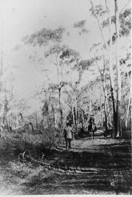 Halls Gap & Grampians Historical Society
Photograph - B/W, C 1880s
This photo is of the road approaching Delley's Bridge. It shows methods of transport and the access route to Halls Gap in the late 19th Century.A man with a walking stick walking away from the camera on a rutted dirt road through trees and bush. Another man is approaching from the opposite direction on horseback.access routes, roads -
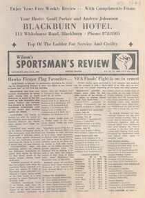 Whitehorse Historical Society Inc.
Magazine - Periodical, Wilson's Sportsman's Review, 30/07/1988 12:00:00 AM
A sportsman's pamphlet Vol. 54 No. 2665A sportsman's pamphlet Vol. 54 No. 2665 issued free from the proprietors of the Blackburn Hotel, 111 Whitehorse Road, Blackburn covering football, soccer and horse racing.A sportsman's pamphlet Vol. 54 No. 2665wilson's sportsman's review, sport, blackburn hotel -
Whitehorse Historical Society Inc.
Document, Emil Stoll
An extract from the Stoll Family History.An extract from the Stoll Family History about Emil Stoll who emigrated to Victoria and lived in L.L. Vale Road, Vermont, including a letter to Valda Arrowsmith.An extract from the Stoll Family History. stoll, emil, arrowsmith, valda, tully, john -
 Bayside Gallery - Bayside City Council Art & Heritage Collection
Photograph, Department of Crown Lands and Survey, Victoria, Melbourne Project: Brighton and Elwood, 1976
The Department of Crown Lands and Survey (1857-1983) was responsible for the administration of survey and mapping and the sale, occupation and management of crown land throughout its existence. This aerial photograph shows parts of Brighton and Elwood and was taken on 1 December 1976brighton, elwood, department of crown lands and survey, aerial photograph, elsternwick park, point ormond, north road, ormond esplanade, st kilda street, glen huntly road, bayside, port phillip bay, map, cartographic material, melbourne project 1976 -
Glenelg Shire Council Cultural Collection
Photograph - Photograph - Bridgewater Construction, n.d
Port of Portland Authority ArchivesFront: Back- Margin ruled in pencil, diagonal in pencil. 'C' 4x2 1/4 - Pencil 'Bridgewater road bridge 29/3/57 looking s.s.w'- written in blue biro. 'Otway Street Bridge - Pencilport of portland archives, otway street bridge, bridgewater road bridge construction -
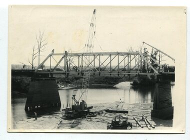 Orbost & District Historical Society
black and white photographs, 1977
This is a series of photographs of the demolition of the 1922 bridge across the Snowy River at Orbost. This bridge over the Snowy River was opened on July 4 1922. It was constructed in 1922 alongside the previous suspension bridge. Its building was a combined effort of the Victorian Railways and the Country Roads Board at a cost of 35,000 pounds. It was replaced in 1976 by the present bridge after several major floods.This bridge was replaced in 1976 after several major floods. These photographs record the demolition of that bridge.Ten black / white photographs of a road bridge demolition. In the photographs are cranes, one on a barge, and workmenon back - Orbost Snowy River Bridge demolition 1977 -
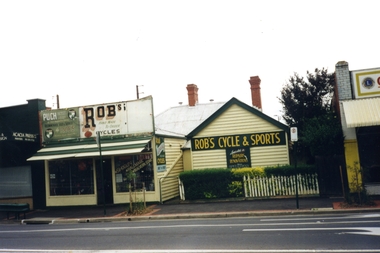 Whitehorse Historical Society Inc.
Photograph, Robs Cycles and Sports, 1989
George Robinson opened Robs Cycles in 1945 and worked out of the Blackburn Road Premises until 1999. He was one of the few specialist bike repairer in Melbourne and also did repairs for importers, wholesalers and even other bike shops. George used to race bikes from Blackburn Hotel and Healesville.Coloured photograph of Robs Cycles and Sports shop, Blackburn Road Blackburn, just north of the railway line.robs cycles, robinson, george -
Tatura Irrigation & Wartime Camps Museum
Book, My War - More than 150 epic events of WW2, 1990
Cover features navy, red and pale blue stripes with main area white with soldier in uniform. Each page features front pages from the sun during wartime. Telling main stories of the war.. "The Sun" -
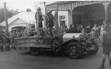 Stawell Historical Society Inc
Photograph, Stawell Scouts -- 5 Photos
Max Liddiard's 1920's car (Bentley) decorated for Main Street procession c1952 in Main Street near Corner of Patrick Street. L A Horne in background of photo. Scouts on decorated vehicle and in Parade. -
 Whitehorse Historical Society Inc.
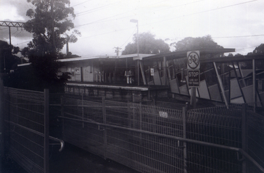
Photograph, Railway tracks looking west, 1/06/2009
One of a collection of photographs taken of the Nunawading Railway Station prior to the lowering of the railway line and building of the new railway station on the western side of Springvale Road so that the Springvale Road Rail Crossing can be eliminated.Black & white photograph of he precinct surrounding the Nunawading Station and the Springvale Road Railway crossing. This photograph is the railway crossing and tracks looking west to Blackburn. See NP 3545 to NP3567 for the complete set of photographsnunawading railway station, springvale road nunawading, redevelopment of railway line/springvale road. -
 Whitehorse Historical Society Inc.
Photograph, Railway Platform from south side, 1/06/2009
One of a collection of photographs taken of the Nunawading Railway Station prior to the lowering of the railway line and building of the new railway station on the western side of Springvale Road so that the Springvale Road Rail Crossing can be eliminated.Black & white photograph of the precinct surrounding the Nunawading Station and the Springvale Road Railway crossing. This photograph is railway station looking from north side of station. See NP 3545 to NP3567 for the complete set of photographsnunawading railway station, springvale road nunawading, redevelopment of railway line/springvale road. -
 Port of Echuca
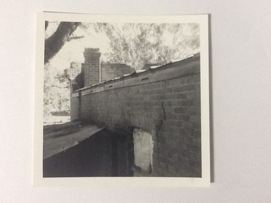
Black and white photograph, 1975
The brick old Murray River Sawmill office was demolished around 1975. This photograph is of the side of the building taken from behind. It shows a corrugated lean-to and a window or door way that appears to be blocked off. There is a large crack in the brick work wall beside this doorway. Part of the back of the front brick facade is visible behind a brick chimney. This relates to photographs P000106, P000107.Sawmills in the Echuca area were historically and socially significant being a large employer in the area. The Murray River sawmill was one of the biggest and longest operating sawmills in the area.Black and white photograph of the old Murray River Sawmills building, taken from the road. Shows view from a rear side, with a window and corrugated iron lean-to. Part of back of facade can be seen as well as the chimney.On back of the photograph in pencil "Old Murray R Sawmills bldg, in from road." In black pen "Old office demolished c.1975" stamped in blue ink "0932"murray river sawmills, echuca, sawmills, echuca, vicotria, pullicino, j -
 City of Kingston
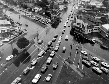
Photograph - Black and white, c. 1950
The image shows a line of traffic travelling along South Road in response to traffic light signlas while an increasing number of cars are banking up along Nepean Highway, also in response to traffic light signals.This image provides a strong contrast to images from earlier eras of the same intersection. The amount of traffic has increased enormously as well as commercial development.Black and white photograph with an aerial view of the intersection of Nepean Highway and South Road, taken from above the Moorabbin Council Chambers.Handwritten in black ink Pic [indecipherable] / 1000 Handwritten in red ink: 150%moorabbin, traffic lights, cars, nepean highway -
 Kew Historical Society Inc
Photograph - Former Kew Post Office : Exterior wall, 1996
A civic campaign for new public offices developed in Kew in the 1880s. After much deliberation, the location chosen was the junction of Bulleen and Cotham Roads. The buildings were designed by George Watson and John Henry Harvey, architects within the Department of Public Works (Victoria). Building was commenced in 1887, and after one year, the buildings were opened. The Post Office was transferred to the new Commonwealth Government in 1901. The Police Station and Court House, sold by the Victorian Government to the City of Boroondara in 2007, are now a community cultural centre and performing arts venue.The buildings were listed on the Victorian Heritage Register Register (HO885) in 1991. They are historically and architecturally significant to the State of Victoria because Watson and Harvey's designs exhibit diversity in integrating civil offices, they accommodate the apex of road junctions, and they demonstrate a departure from the contemporaneously favoured High Victorian Classical to the Queen Anne style in the design of civic buildings.Side wall, facing Cotham Road of the former Kew Post Officekew court house, public offices -- kew (vic), kew police station, kew post office