Showing 113079 items
matching road
-
 Eltham District Historical Society Inc
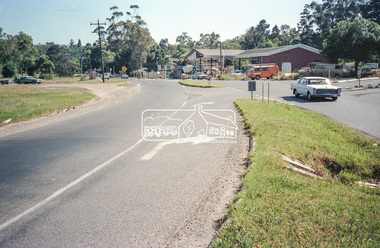
Negative - Photograph, Intersection of Mt Pleasant Road at Main Road, Eltham, c.Dec. 1983
Reconstruction work was planned for Main Road to install a roundabout at Mount Pleasant Road. Traffic to Lower Plenty and Templestowe to be diverted down Bridge Street (and Bolton Street) effective January 1984. The proposed roundabout did not proceed. Instead traffic islands on Mount Pleasant Road were installed in place of temporary blocked out islands and revised extended driveway to properties 622-642 Main Road with access off Mount Pleasant Road instead.Film - Kodak CM 400 5079 7 strips, 26 framesinfrastructure, roads, road construction, roundabout, road sign, main road, mount pleasant road, eltham, service station -
 Eltham District Historical Society Inc
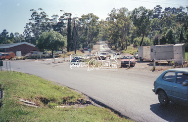
Negative - Photograph, Intersection of Mt Pleasant Road at Main Road, Eltham, c.Dec. 1983
Reconstruction work was planned for Main Road to install a roundabout at Mount Pleasant Road. Traffic to Lower Plenty and Templestowe to be diverted down Bridge Street (and Bolton Street) effective January 1984. The proposed roundabout did not proceed. Instead traffic islands on Mount Pleasant Road were installed in place of temporary blocked out islands and revised extended driveway to properties 622-642 Main Road with access off Mount Pleasant Road instead.Film - Kodak CM 400 5079 7 strips, 26 framesinfrastructure, roads, road construction, roundabout, road sign, main road, mount pleasant road, eltham -
 Eltham District Historical Society Inc
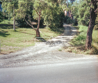
Negative - Photograph, Intersection of Mt Pleasant Road at Main Road, Eltham, c.Dec. 1983
Reconstruction work was planned for Main Road to install a roundabout at Mount Pleasant Road. Traffic to Lower Plenty and Templestowe to be diverted down Bridge Street (and Bolton Street) effective January 1984. The proposed roundabout did not proceed. Instead traffic islands on Mount Pleasant Road were installed in place of temporary blocked out islands and revised extended driveway to properties 622-642 Main Road with access off Mount Pleasant Road instead.Film - Kodak CM 400 5079 7 strips, 26 framesinfrastructure, roads, road construction, roundabout, road sign, main road, mount pleasant road, eltham -
 Whitehorse Historical Society Inc.
Newspaper - Article, Lake Road Estate, 7/10/1970
'It's a genuine piece of Bellbird country' [ article on 36 lot subdivision, Lake Road Estate, Lake Road, Blackburn by developers Mark Padgett and Co Pty Ltd]mark padgett & co pty ltd, lake road, blackburn, lake road estate, land subdivision -
 Whitehorse Historical Society Inc.
Photograph, Canterbury Road, Vermont C.1970, C.1970
Part of Tim Shambrook's Collection for 'This is Vermont'. Not used.Coloured photo of Canterbury Road, Vermont, taken in 1970, showing double lane road with median strip looking East. Roof of Cadbury-Schweppes Factory can be seen.canterbury road, vermont., cadbury-schweppes, shambrook, tim -
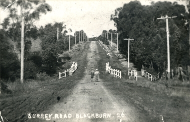 Whitehorse Historical Society Inc.
Photograph, Surrey Road, Blackburn, 1918
Used by Donor in 'Blackburn - A Picturesque History'.Black and white photo of Surrey Road, Blackburn, looking south from Springfield Road 1918. Children are Ormond and Jack Bird. Page 55 of Da Costa book.bird, ormond, jack, surrey road blackburn -
 Whitehorse Historical Society Inc.
Photograph, Old house in Canterbury Road Blackburn, 1971
Black and white photo of old house standing well back as a result of Sub-division in Canterbury Road (south side) B/N Blackburn and Springvale Roads, 1971.canterbury road, blackburn -
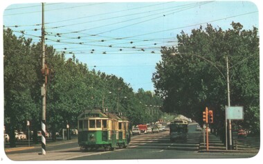 Melbourne Tram Museum
Postcard, Valentine's, W2 584 St Kilda Road, late 1960's
Postcard - Valentine - colour - with rounded edges of W2 584 (City Route 64) followed by another W2 (Route 19) northbound St Kilda Road at the City Road intersection. Note the traffic lights on the centre of the road pole. Divided back type, card number LV 019.trams, tramways, st kilda road, city road, w2 class, tram 584 -
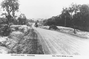 Ringwood and District Historical Society
Photograph, Maroondah Highway East, Ringwood- c.1920. "Healesville Road, Ringwood" postcard featuring westward view along Whitehorse Road towards Mount Dandenong Road
4 photographs (2 large black and white, 2 small sepia postcard)Postcard labelled Healesville Road, Ringwood. Typed under large copy: "Looking down a dry Maroondah Highway from outside (eventual) Civic Centre site towards Mt. Dandenong Rd corner." -
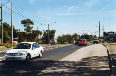 Whitehorse Historical Society Inc.
Photograph, Prior to Construction of Mitcham Road, 1/02/2000 12:00:00 AM
Coloured photograph of Mitcham Road, looking towards Springvale Road Junction. Donvale Bus Terminus on left, Mobil Service Station on right, as is a small shopping centre which consisted in earlier days as only a family operated general store. This photograph was taken just prior to widening of Mitcham Road.mitcham road, donvale, springvale road -
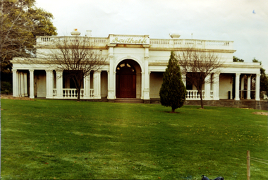 Kew Historical Society Inc
Photograph, Façade of ‘Southesk', Cotham Road, 1970
Colour enlargement of a photograph (slide) of Southesk (formerly Ordsall) in Cotham Road, Kew (demolished 1970).Colour photograph of the front lawn and façade of ‘Southesk’ (formerly ‘Ordsall’, built for John Halfey in 1882). The house was located on the corner of Cotham Road and Charles Street, Kew. The Italianate mansion was built in the Renaissance villa style on a bluestone plinth. Two balustrades surrounded the parapet of the roof and ran between the groups of pillars on either side of the entrance porch. The verandah was tiled and wide and Corinthian columns supported its roof. When the house passed into the hands of the City of Kew in 1948, the landscaping and formal flower beds were removed and replaced by lawns.The house was demolished in 1970.david carnegie, john halfey, southesk - cotham road - kew (vic), ordsall - cotham road - kew (vic) -
 Marysville & District Historical Society
Photograph (Item) - Colour photograph, Unknown
A colour photograph taken of a house in Pack Road in Marysville in Victoria.A colour photograph taken of a house in Pack Road in Marysville in Victoria.pack road, marysville, victoria, photograph -
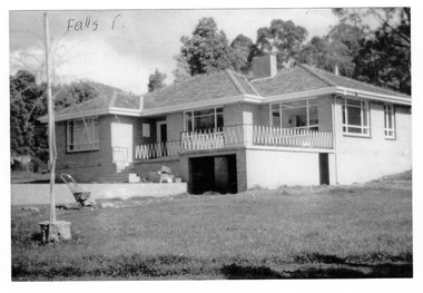 Marysville & District Historical Society
Photograph (Item) - Black and white photograph, 1961
A black and white photograph of a house in Falls Road in Marysville in Victoria.A black and white photograph of a house in Falls Road in Marysville in Victoria. This house belong the the Gianforte family.Falls Rdfalls road, marysville, victoria, photograph, gianforte family -
 Bacchus Marsh & District Historical Society
Map, Plan of land purchased by the Bacchus Marsh Shire Council from Mr. T. Low for a deviation of the Melbourne to Ballarat main road. 1877
The date of this plan is 1877 and the land indicted on it required for a road deviation is shaded in blue. It adjoins the Korkuperrimul Creek on one side which indicates the land is located just a few kilometers to the west of Bacchus Marsh. Single page map showing a portion of land purchased by the Bacchus Marsh Shire from Mr Thomas Low for the purpose of a road deviation. Land held by David Robertson is also shown on the map. Scale: 2 chains to 1 inch. Part of a set of maps which are pasted into a bound volume containing 76 maps or plans in total. High resolution digital image stored on BMDHS computer network. Surveyed by W. E. Standfield, Shire Engineer, Bacchus Marsh, 12/4/77bacchus marsh roads and streets, melbourne to ballarat road -
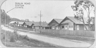 Ringwood and District Historical Society
Photograph, Two images of 1924 Dublin Road Station Estate land sale promotional photograph - War of 1914-18 Soldiers homes on Bedford Road
Typed below photograph, "10 modern villas recently erected alongside the estate". Typed below photograph, "Soldiers Homes, Bedford Road. 1924." Catalogue card reads, "Soldiers homes Bedford Road, looking east from outside shops corner Illoura Ave. War of 1914-18 Soldiers Homes. From land sale brochure." -
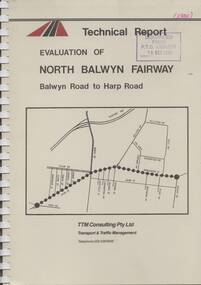 Melbourne Tram Museum
Document - Report, TTM Consulting, "Evaluation of North Balwyn Fairway, Balwyn Road to Harp Road", May. 1985
Approx a 70 page, comb bound, report by TTM Consulting in May 1985, titled "Evaluation of North Balwyn Fairway, Balwyn Road to Harp Road" for the Public Transport Corporation. Evaluates the impact of a Fairway along the North Balwyn tram route. Principal conclusions given on page - tram travel times in both AM and PM peaks were virtually unchanged. Document has many tables at rear, graphs and maps.Stamped on cover and inside page "Discarded from PTC Library 19 Oct 1989" and "1985" in red ink on front cover.trams, tramways, north balwyn, fairways, traffic control, tram priority -
Lara RSL Sub Branch
Photograph, Burlington J Macintyre 45 Walkers Road Lara
Burlington J Macintyre 45 Walkers Road Lara (picture) -
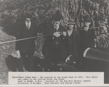 Lorne Historical Society
Photograph, Opening of Great Ocean Road by Howard Hitchcock 1932
A. Bell, surveyor,Photograph of Opening of Great Ocean Road 1932 by Howard Hitchcockgor opening 1932. a. bell surveyor. big hill estate. howard hitchock. george clarke -
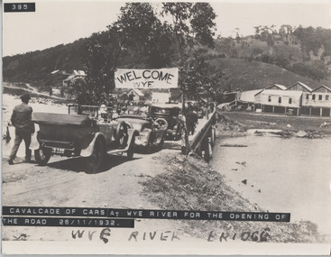 Lorne Historical Society
Photograph, Cavalcade of cars at Wye River Road Opening 26th November 1932
Cavalcade of cars for opening of the road at Wye River November 1932 g.o.r. opening, cavalcade of cars, wye river bridge -
 Eltham District Historical Society Inc
Photograph, Shoestring' Metery Road, Eltham 1990, 1990
Colour photograph of 'Shoestring' Metery Road, Elthamshowing gateway 1990.houses, shoestring, metery road, eltham -
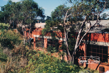 Eltham District Historical Society Inc
Photograph, Hat Factory, Sherbourne Road, Eltham
Six coloured photographs of Latiner's hat factory, Sherbourne Roadindustry, hat factory, sherbourne road, eltham, latiner -
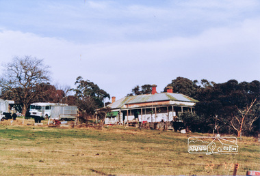 Eltham District Historical Society Inc
Photograph, Murray Road, Wattle Glen
Colour photograph of old house Murray Road, Wattle Glenwattle glen, murray road, houses -
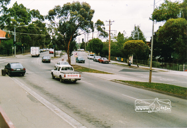 Eltham District Historical Society Inc
Photograph, Main Road, Eltham near Dudley Street
Three colour photographs of Main Road, Eltham at Dudley Streetmain road, dudley street, eltham -
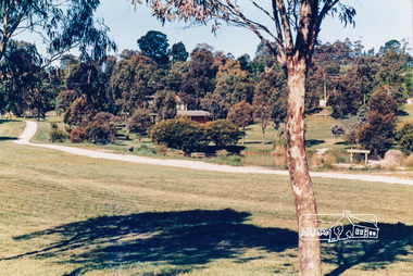 Eltham District Historical Society Inc
Photograph, Town Park, Main Road, Eltham
Colour photograph of Eltham Town Park near Main Roadmain road, eltham, twon park -
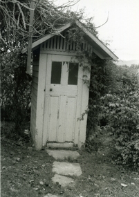 Ringwood and District Historical Society
Photograph-B&W, Hill's Dairy, Canterbury Road, Ringwood 1989-Outside Toilet, 6/07/1989
Hill's Dairy, Canterbury Road, Ringwood 1989-Outside ToiletToilet -
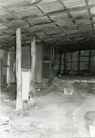 Ringwood and District Historical Society
Photograph-B&W, Hill's Dairy, Canterbury Road, Ringwood 1989-Barn interior, 6/07/1989
Hill's Dairy, Canterbury Road, Ringwood 1989-Barn interiorInside the Barn -
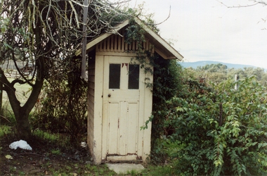 Ringwood and District Historical Society
Photograph-Colour, Hill's Dairy, Canterbury Road, Ringwood 1989-Outside Toilet, 6/07/1989
Hill's Dairy, Canterbury Road, Ringwood 1989-Outside ToiletToilet -
 Ringwood and District Historical Society
Photograph-Colour, Hill's Dairy, Canterbury Road, Ringwood 1989-Barn Interior, 6/07/1989
Hill's Dairy, Canterbury Road, Ringwood 1989-Barn InteriorHill's Dairy / Inside the Barn -
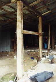
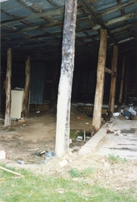 Ringwood and District Historical Society
Photograph-Colour, Hill's Dairy, Canterbury Road, Ringwood 1989-Barn Interior, 6/07/1989
Hill's Dairy, Canterbury Road, Ringwood 1989-Barn InteriorHill's Dairy Barn -
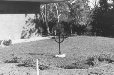 Ringwood and District Historical Society
Photograph, The Garden of Remembrance at Church of England Church in Warrandyte Road, Ringwood in 1974, 1974
The Garden of Remembrance at Church of England Church in Warrandyte Road in 1974Written on back of photograph, "C. of E. ash plot, Jan. 1974. Cross is from old church in Ringwood St."