Showing 1859 items
matching the rock
-
 Flagstaff Hill Maritime Museum and Village
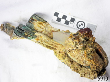
Domestic object - Spoon, circa 1878
These table spoons are from the wreck of the LOCH ARD, a Loch Line ship of 1,693 tons which sailed from Gravesend, London, on 2 March 1878 with 17 passengers and a crew of 36 under Captain George Gibbs. “The intention was to discharge cargo in Melbourne, before returning to London via the Horn with wool and wheat”. Instead, on 1 June 1878, after 90 days at sea, she struck the sandstone cliffs of Mutton Bird Island on the south west coast of Victoria, and sank with the loss of 52 lives and all her cargo. The manifest of the LOCH ARD listed an array of manufactured goods and bulk metals being exported to the Colony of Victoria, with a declared value of £53,700. (202 bills of lading show an actual invoice value of £68, 456, with insurance underwriting to £30,000 of all cargo). Included in the manifest is the item of “Tin hardware & cutlery £7,530”. These table spoons are some of 482 similar items of electro-plated cutlery from the LOCH ARD site, comprising spoons and forks of various sizes but all sharing the same general shape or design and metallic composition. 49 of these pieces display a legible makers’ mark — the initials “W” and “P” placed within a raised diamond outline, which is in turn contained within a sunken crown shape — identifying the manufacturer as William Page & Co of Birmingham. An electroplater’s makers’ marks, unlike sterling silver hallmarks, are not consistent identifiers of quality or date and place of manufacture. A similar line of five impressions was usually made to impress the consumer with an implication of industry standards, but what each one actually signified was not regulated and so they varied according to the whim of the individual foundry. In this case, the maker’s marks are often obscured by sedimentary accretion or removed by corrosion after a century of submersion in the ocean. However sufficient detail has survived to indicate that these samples of electro-plated cutlery probably originated from the same consignment in the LOCH ARD’s cargo. The generally common range of marks are drawn from 255 tea spoons, 125 dessert spoons, and 99 table forks. These marks are clearly visible in 66 instances, while the same sequence of general outlines, or depression shapes, is discernible in another 166 examples. Suggested trade names for William Page & Co’s particular blend of brass plating are ‘roman silver’ or ‘silverite’. This copper alloy polishes to a lustrous gold when new, discolouring to a murky grey with greenish hue when neglected. HISTORY OF THE LOCH ARD The LOCH ARD belonged to the famous Loch Line which sailed many ships from England to Australia. Built in Glasgow by Barclay, Curdle and Co. in 1873, the LOCH ARD was a three-masted square rigged iron sailing ship. The ship measured 262ft 7" (79.87m) in length, 38ft (11.58m) in width, 23ft (7m) in depth and had a gross tonnage of 1693 tons. The LOCH ARD's main mast measured a massive 150ft (45.7m) in height. LOCH ARD made three trips to Australia and one trip to Calcutta before its final voyage. LOCH ARD left England on March 2, 1878, under the command of Captain Gibbs, a newly married, 29 year old. She was bound for Melbourne with a crew of 37, plus 17 passengers and a load of cargo. The general cargo reflected the affluence of Melbourne at the time. On board were straw hats, umbrella, perfumes, clay pipes, pianos, clocks, confectionary, linen and candles, as well as a heavier load of railway irons, cement, lead and copper. There were items included that intended for display in the Melbourne International Exhibition in 1880. The voyage to Port Phillip was long but uneventful. At 3am on June 1, 1878, Captain Gibbs was expecting to see land and the passengers were becoming excited as they prepared to view their new homeland in the early morning. But LOCH ARD was running into a fog which greatly reduced visibility. Captain Gibbs was becoming anxious as there was no sign of land or the Cape Otway lighthouse. At 4am the fog lifted. A man aloft announced that he could see breakers. The sheer cliffs of Victoria's west coast came into view, and Captain Gibbs realised that the ship was much closer to them than expected. He ordered as much sail to be set as time would permit and then attempted to steer the vessel out to sea. On coming head on into the wind, the ship lost momentum, the sails fell limp and LOCH ARD's bow swung back. Gibbs then ordered the anchors to be released in an attempt to hold its position. The anchors sank some 50 fathoms - but did not hold. By this time LOCH ARD was among the breakers and the tall cliffs of Mutton Bird Island rose behind the ship. Just half a mile from the coast, the ship's bow was suddenly pulled around by the anchor. The captain tried to tack out to sea, but the ship struck a reef at the base of Mutton Bird Island, near Port Campbell. Waves broke over the ship and the top deck was loosened from the hull. The masts and rigging came crashing down knocking passengers and crew overboard. When a lifeboat was finally launched, it crashed into the side of LOCH ARD and capsized. Tom Pearce, who had launched the boat, managed to cling to its overturned hull and shelter beneath it. He drifted out to sea and then on the flood tide came into what is now known as LOCH ARD Gorge. He swam to shore, bruised and dazed, and found a cave in which to shelter. Some of the crew stayed below deck to shelter from the falling rigging but drowned when the ship slipped off the reef into deeper water. Eva Carmichael had raced onto deck to find out what was happening only to be confronted by towering cliffs looming above the stricken ship. In all the chaos, Captain Gibbs grabbed Eva and said, "If you are saved Eva, let my dear wife know that I died like a sailor". That was the last Eva Carmichael saw of the captain. She was swept off the ship by a huge wave. Eva saw Tom Pearce on a small rocky beach and yelled to attract his attention. He dived in and swam to the exhausted woman and dragged her to shore. He took her to the cave and broke open case of brandy which had washed up on the beach. He opened a bottle to revive the unconscious woman. A few hours later Tom scaled a cliff in search of help. He followed hoof prints and came by chance upon two men from nearby Glenample Station three and a half miles away. In a state of exhaustion, he told the men of the tragedy. Tom returned to the gorge while the two men rode back to the station to get help. By the time they reached LOCH ARD Gorge, it was cold and dark. The two shipwreck survivors were taken to Glenample Station to recover. Eva stayed at the station for six weeks before returning to Ireland, this time by steamship. In Melbourne, Tom Pearce received a hero's welcome. He was presented with the first gold medal of the Royal Humane Society of Victoria and a £1000 cheque from the Victorian Government. Concerts were performed to honour the young man's bravery and to raise money for those who lost family in the LOCH ARD disaster. Of the 54 crew members and passengers on board, only two survived: the apprentice, Tom Pearce and the young woman passenger, Eva Carmichael, who lost all of her family in the tragedy. Ten days after the LOCH ARD tragedy, salvage rights to the wreck were sold at auction for £2,120. Cargo valued at £3,000 was salvaged and placed on the beach, but most washed back into the sea when another storm developed. The wreck of LOCH ARD still lies at the base of Mutton Bird Island. Much of the cargo has now been salvaged and some was washed up into what is now known as LOCH ARD Gorge. Cargo and artefacts have also been illegally salvaged over many years before protective legislation was introduced. One of the most unlikely pieces of cargo to have survived the shipwreck was a Minton porcelain peacock - one of only seven in the world. The peacock was destined for the Melbourne International Exhibition in 1880. It had been well packed, which gave it adequate protection during the violent storm. Today, the Minton peacock can be seen at the Flagstaff Hill Maritime Museum in Warrnambool. From Australia's most dramatic shipwreck it has now become Australia's shipwreck artefact and is one of very few 'objects' on the Victorian State Heritage Register most valuable. The LOCH ARD shipwreck is of State significance – Victorian Heritage Register S 417. Flagstaff Hill’s collection of artefacts from LOCH ARD is significant for being one of the largest collections of artefacts from this shipwreck in Victoria. It is significant for its association with the shipwreck, which is on the Victorian Heritage Register (VHR S417). The collection is significant because of the relationship between the objects, as together they have a high potential to interpret the story of the LOCH ARD. The LOCH ARD collection is archaeologically significant as the remains of a large international passenger and cargo ship. The LOCH ARD collection is historically significant for representing aspects of Victoria’s shipping history and its potential to interpret sub-theme 1.5 of Victoria’s Framework of Historical Themes (living with natural processes). The collection is also historically significant for its association with the LOCH ARD, which was one of the worst and best known shipwrecks in Victoria’s history. Unrestored table spoons from the wreck of the LOCH ARD. The spoon design has a flattened fiddle-back handle, with a thin stem or shank, flared collar, and a shallow rounded bowl. The spoons metallic composition is a thin layer of brass alloy which has partially corroded back to a nickel-silver base metal. Some verdigris. Spoons are covered in large amount of concretion. Pieces of rock, glass and shell are embedded in concretion. Large piece of glass visible.10 spoons in group.flagstaff hill maritime museum, shipwreck coast, great ocean road, loch line, loch ard, mutton bird island, loch ard gorge, electroplated cutlery, loch ard shipwreck, william page and co, birmingham brass plating, table spoons -
 Bendigo Historical Society Inc.
Map - CAMPBELL COLLECTION: BENDIGO AND DISTRICT MAPS
Map. Bendigo Whipstick Forest Park, 1:75,000, reserved forest and crown land, highway main road access forest tracks. New Moon Mine, Elliot Dam, Nuggety Dam, Rogers Tree, Old Tom Mine, Blow Holes, Skylark Dam, Monument Rock, Hartland Eucalyptus Still and Dam, Hartland Eucalyptus Farm, Millwood Dam, Sandner Eucalyptus Still Site, Various unmarked dams. (number 391 in map cupboard 1)map, bendigo, country lands -
 Bendigo Historical Society Inc.
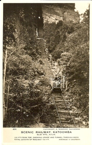
Photograph - BASIL MILLER COLLECTION: SCENIC RAILWAY - KATOOMBA N.S.W
Two black and white photographs of the scenic railway located at Katoomba N.S.W. Inscriptions: Number 503 on front of one and 496 on other. They both have the same inscriptions on front; Copyright. A. Manning Katoomba, Scenic Railway Katoomba, Blue Mountains N.S.W. Grade at this point52 degrees for a distance of 181 feet (503). 1200 feet from the top showing grade and tunnel through rock (496). Total length of railway 1300 feet at an average gradient of 45 degrees.person, individual, basil miller -
 National Vietnam Veterans Museum (NVVM)
Photograph, Gibbons, Denis, A Few Beers
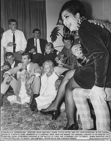
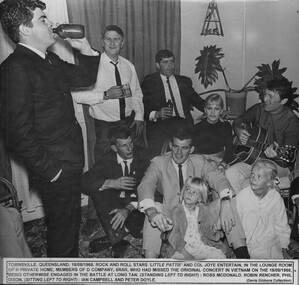
A black and white photograph of Townsville, Qld, 18/08/1968, Rock and Roll stars Little Patty and Col Joye entertain in the lounge room of a private home. Members of D Company 6 RAR, who had missed the oroginal concert in Vietnam on the 18/08/1966 being otherwise engaged in the battle at Long Tan. Standing left to right Mrs Doyle, Robin Rencher, Phil Dixon. sitting left to right Ian Campbell and Peter Doyle.photograph, townsville, battle of long tan, little patti, col joy, d coy, 6 rar, robin rencher, phil dixon, ian campbell, peter doyle, gibbons collection catalogue -
 National Vietnam Veterans Museum (NVVM)
Photograph, Gibbons, Denis, A Few More Beers
A black and white photograph of Townsville, QLD, 18/08/1968, Rock and Roll stars Little Pattie and Col Joye entertain in the lounge room of a private home. Members of D Company 6 RAR, who had missed the original concert in Vietnan on the 18/08/1966, being otherwise engaged in the Battle of Long Tan and missed the original concert. Standing left to right Robin Rencher, Phil Dixon, sitting left to right Ian Campbell, Peter Doyle and a backup singer.photograph, townsville, d company, 6 rar, battle of long tan, little patti, col joy, robin rencher, phil dixon, ian campbell, peter doyle, gibbons collection catalogue -
 National Vietnam Veterans Museum (NVVM)
Photograph, Gibbons, Denis, Moor Beers
A black and white photograph of Townsville, QLD, 18/08/1968, Rock and Roll Stars Little Pattie and Col Joye entertain in the lounge room of a private home.Members of from D Company 6 RAR, who had missed the original concert in Vietnam on the 18/08/1966 being otherwise engaged inthe Battle of Long Tan. Standing left to right Ross MAudio, CDonald, Robin Rencher, Phil Dixon, sitting left to right Ian Campbell and Peter Doyle.photograph, townsville, little patti, col joy, battle of long tan, ross maudio, cdonald, robin rencher, phil dixon, ian campbell, peter doyle, gibbons collection catalogue -
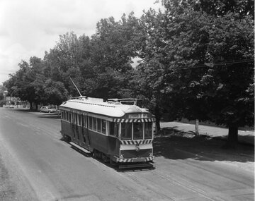 Ballarat Tramway Museum
Photograph - Black & White Photograph/s, Chris Wurr, late 1960's or early 1970's
Yields information about the tramway and the street scene in Lydiard St Nth during the last few years of tramway operation.Black and White photograph of SEC tram 34 travelling along Lydiard St. North, bound for the Lydiard St. North terminus. Photo shows the tree lined route and how the road surfaces was not fully sealed to the gutter, but with a crushed rock edge. Photo taken by Chris Wurr during late 1960's or early 1970's. Photocopy made 4/1999 for display purposes. Copy 2 - as above, ex Alan Bradley 5/2007 - added 27/7/2007.Copy 1 - On rear, in black stamp ink "Photo by Chris Wurr / 12 Truscott Street, Ararat 3377 / (053) 523403. Copy 2 - Additional words to above "Donated to BTPS by and"trams, tramways, lydiard st. nth, tram 34 -
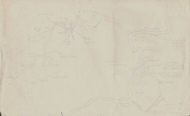 Bendigo Historical Society Inc.
Document - PETER ELLIS COLLECTION: SKETCH OF THE BARFOLD GORGE
Two hand sketched maps on same sheet of paper, one of the location of the Barfold Gorge in relation to surrounding towns, Mt Alexander and Turpin;s Falls. The second map is a part of the Campaspe River location of the Barfold Gorge. Shown is the location of columns, pools, type of rock, Mitchell's Falls, tunnel, cave, Queen's Falls, house, windmill, fences and places where access to the bottom of the gorge is possible. Car track and scale of 1 mile = 6 inches are also shown.place, land, barfold gorge, peter ellis collection, mitchell's falls, queen's falls, turpin's falls -
 Wodonga & District Historical Society Inc
Album - Hume Reservoir Australia Album - Plans and Progress Photos - River Murray Water Scheme, Department of Public Works, N.S.W, 1927
This set of photos is from a leather bound album bearing the inscription "HUME RESERVOIR AUSTRALIA" plus 'The Rt. Hon. L. C. M. S. Amery, P. C., M .P.' all inscribed in gold. It was presented to The Rt. Hon. L. C. M. S. Amery, P. C., M. P, Secretary of State for Dominion Affairs on the occasion of his visit to the Hume Reservoir on 2nd November 1927. This album is of local and national significance as it documents the planning and development of the Hume Reservoir up to 1927. It was the largest water reservoir in the British Empire. The album records the pioneering engineering work that went into its construction.1. Locality Plan and Plan of Dam. The dam is about ten miles by road upstream from Albury and about three-quarters of a mile below the confluence of the Mitta Mitta River and the Murray River. Its main features consist of a concrete portion across the bed of the river with earth embankment at both ends. The foundations throughout are on hard granite, found at an average depth of about 40 feet below the surface, the centre line being located to take advantage of the most favourable rock levels.Heading on page "WORKS UNDER RIVER MURRAY WATERS AGREEMENT/HUME RESERVOIR" Beneath top diagram "FIG. 1. ELEVATION" Beneath second diagram "FIG. 2. PLAN" On map "LOCALITY PLAN"hume reservoir australia, river murray waters scheme, hume weir diagrams, hume weir location -
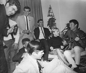 National Vietnam Veterans Museum (NVVM)
Photograph, Gibbons, Denis, Little Pattie And Col Joye
Denis Gibbons (1937 – 2011) Trained with the Australian Army, before travelling to Vietnam in January 1966, Denis stayed with the 1st Australian Task Force in Nui Dat working as a photographer. For almost five years Gibbons toured with nine Australian infantry battalions, posting compelling war images from within many combat zones before being flown out in late November 1970 after sustaining injuries. The images held within the National Vietnam Veterans Museum make up the Gibbons Collection. A black and white photograph taken in Townsville, Queensland, 18/08/1968. Rock and Roll stars Little Pattie and Col Joye entertain in the lounge of a private home. Members of D Coy 6 RAR who missed the original concert in Vietnam on the 18/08/1966 being otherwise engaged in the Battle of Long Tan. Standing left to right Ross MAudio, C Donald, Robin Rencher, Peter Doyle, Phil Dixon. Sitting left to right Ian Campbell and Dave Sabben.photograph, entertainer, col joy, d coy, 6 rar, battle of long tan, gibbons collection catalogue, ross maudio, robin rencher, peter doyle, phil dixon, ian campbell, dave sabben, little pattie, c donald, denis gibbons -
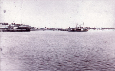 Lakes Entrance Regional Historical Society (operating as Lakes Entrance History Centre & Museum)
Photograph - New Works, 1890c
Three copies -Sepia photograph showing dunes, houses and Works buildings and boats at the entrance to Gippsland Lakes from ocean - Bass Strait. Photo shows two PWD houses on left and small school building, plus other Works buildings. Flagstaff on dune above houses. Large barge on left in front of houses. Large passenger steamer at New Works wharf with people waiting, has flags and bunting, two masted ketch on right of rock groynes. Lakes Entrance Victoriajetties, boats and boating, settlement, historic site -
 Bendigo Historical Society Inc.
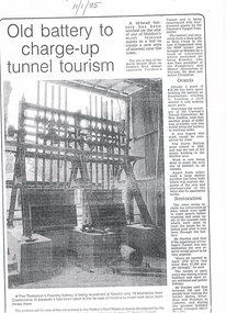
Newspaper - LONG GULLY HISTORY GROUP COLLECTION: OLD BATTERY TO CHARGE-UP TUNNEL TOURISM
BHS CollectionThree photocopies of a newspaper article titled Old Battery to charge-up tunnel tourism. The date 11/1/85 is written at the top of the article. There is a photo of the battery mentioning it was the Thompson's Foundry battery and it was being re-erected at Maldon, near Castlemaine. It has been in far of Victoria to crush rock taken from mines there. The battery will be one of the attractions in the Parkin's Reef Reserve being developed by the Conservation, Forests and Lands. Also mentioned is the work of volunteers, grants they received, restoration and tourism.bendigo, history, long gully history group, the long gully history group - old battery to charge-up tunnel tourism, thompson's foundry, parkin's reef reserve, conservation forests and lands department, carman's tunnel, north british mine, parkin's reef, carman's tunnel committee, dr doug kemsley, prospectors' and miners' association of victoria, ken garden, north british mine, george ellis -
Bendigo Historical Society Inc.
Document - MINING REPORTS - MAP OF PART OF THE BENDIGO GOLDFIELD INCLUDING WHITE HILLS AND EAGLEHAWK
BHS CollectionMap of part of the Bendigo Goldfield including White Hills and Eaglehawk. Map shows reef lines, gullies, railway line, tram route, type of rock, name of mine, Calls and Dividends. Also Deepest Mine Victoria Quartz 4614 ft. Names of Mines are Garden Gully United, Great Ext'd Hustlers, Johnson's Reef, South New Moon, New Moon, Catherine Reef, Virginia, Central Red White & Blue, Ironbark, Kock's Pioneer, Carlisle and the Hercules & Energetic.document, gold, mining reports, mining reports, map of part of the bendigo goldfield including white hills and eaglehawk, pabst bendigo goldfield, garden gully united, great ext'd hustlers, johnson's reef, south new moon, new moon, catherine reef, virginia, central red white & blue, ironbark, kock's pioneer, carlisle, hercules & energetic. victoria quartz -
 Melbourne Tram Museum
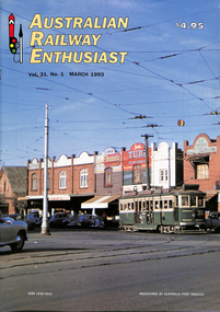
Magazine, Association of Railway Enthusiasts (ARE), "Australian Railway Enthusiast - Vol 31, No. 1, March 1993", Mar. 1993
Magazine - "Australian Railway Enthusiast - Vol 31, No. 1, March 1993", 24 pages, centre stapled, with a front cover colour photo of VR 36, Ormond Road, about to cross the Point Ormond line. Contains a detailed article on both the VR lines by Jim Seletto, featuring photos of 39, 30, 53, 49, MMTB 675 and a colour photo of VR 49 on the rear. Contains maps and diagrams of St Kilda Station. Includes Sandringham and Black Rock line. Published by the ARE.trams, tramways, vr trams, st kilda brighton tramway, sandringham, black rock, maps, st kilda, railways, tram 39, tram 30, tram 53, tram 49, tram 675 -
 The Beechworth Burke Museum
Photograph, 1920 - 1930
Taken between circa 1920 - 1950 this photograph depicts the open mine in the Three Mile Mine at Barramutha. The mine was an important gold resource and was typically mined using a method known as hydraulic sluicing whereby high powered water jets are used to dislodge rock or move sediment. The remaining water sediment slurry is directed through sluice boxes to remove the gold. The Beechworth mining district was one of six mining districts established by the governor-in-council on 4th of January 1858 under the provisions of An Act for Amending the Laws Relating to the Goldfields (21 Vic no. 32).This photograph shows cultural and research value into the historical methods of hydraulic sluicing in the Beechworth mining disctrict. It also shows the evolution of the mining methods and has potential for understanding future engineering endeavors in the context of victorian mine goldfields.Black and White rectangular photograph printed on matte photographic paper.Reverse: Copied from original on loan from Webb (QLD)/ Donated Nov 2009/ Barnawatha Three Mile Mine c1920-1950 Minehead & Slicing/ Managed by John Weir, Peter Jensen, Jack Cox/ Owned by/ the Plain Bros then Parkinsons/ John worked for Pqarkinsons. three mile creek, three mile goldfields, three mile beechworth, goldfields, #beechworth, hydraulic mining, hydraulic sluice, burke museum -
 Greensborough Historical Society
Poster, Victoria. Department of Natural Resources and Environment, Site identification mini poster (#1-2, 4-6, 8-10, 13-14), 2002
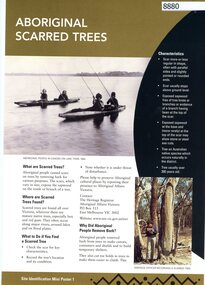
This set produced by the Victorian Department of Natural Resources and Environ met and Aboriginal Affairs Victoria. Mini poster 1: Aboriginal scarred trees; 2 Aboriginal mounds; [3 missing]; 4 Aboriginal flaked stone tools; 5 Aboriginal burials; 6 Aboriginal surface scatters; [7 missing]; 8 Aboriginal ground-edge axes; 9 Aboriginal grinding stones; 10 Aboriginal stone arrangements; [11 missing]; 12 Aboriginal axe-grinding grooves; 13 Aboriginal coastal shell middens; 14 Aboriginal rock art.11 parts of incomplete set, each two sided, text and photographsaborigines - victoria, aboriginal affairs victoria -
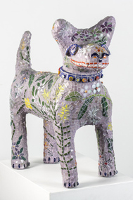 Nillumbik Shire Council
Sculpture: Pamela IRVING (b.1960), Pamela Irving, Green Wedge Larry, 2012
Pamela Irving (born 1960) is a prominent Australian visual artist specialising in bronze, ceramic and mosaic sculptures as well as printmaking and copper etchings. Irving's early art was influenced by artists including Arthur Boyd, John Brack, Noel Connihan, Mirka Mora, Sidney Nolan and John Perceval. In recent years, Irving has been influenced ″by the honest and direct expressiveness of ‘outsider art’ (the art of self-taught or ‘naive artists’) and the craft of ‘memoryware’″ Significantly, this interest grew following Irving's visit to Nek Chand's Rock Garden in Chandigarh, India.Green Wedge Larry - dog sculpture reminiscent of the iconic Larry LaTrobe located at Melbourne City Square. The dog is constructed from Italian Bisazza glass tiles, using a Mapei adhesive system. The theme for his 'coat' is the flora from the local surrounds of Nillumbik, drawing from the 'Live Local Plant Local' Nillumbik plant directory.green wedge, larry, dog, sculpture, mosaic, indigenous flora, irving -
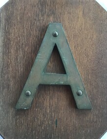 Queenscliffe Maritime Museum
Sign - Metal letter A
The steamship, SS Australia, was built in Greenock, Scotland in 1892, for the P & O Steam Navigation Company. Australia was considered to be one of the most luxurious vessels afloat and she held the speed record from England to Australia at the time. On 21st June 1904, due to pilot error, the Australia hit the notorious Corsair Rock, part of the Point Nepean Reef, on the eastern side of Port Philip heads, opening a gaping 5 meter hole along her keel. Passengers and some of the crew were rescued by craft sent from Queenscliff.Relic from a significant wreck on Corsair Rock at Point NepeanMetal letter A mounted on timber board in front with salvage account on the backAccount of salvage of artefactsign, ships name, ss australia -
![Bend of the River Watt / [by] Nicholas Caire, circa 1876](/media/collectors/550653872162f11fb04854aa/items/577b52c2d0cdd10948cc9307/item-media/577b5328d0cdd10948ccc8b6/item-fit-380x285.jpg) Kew Historical Society Inc
Kew Historical Society IncPhotograph, Anglo-Australasian Photographic Company, Bend of the River Watt, c.1876
Nicholas Caire was born on Guernsey in the Channel Islands in 1837. He arrived in Adelaide with his parents in about 1860. In 1867, following photographic journeys in Gippsland, he opened a studio in Adelaide. From 1870 to 1876 he lived and worked in Talbot in Central Victoria. In 1876 he purchased T. F. Chuck's studios in the Royal Arcade Melbourne. In 1885, following the introduction of dry plate photography, he began a series of landscape series, which were commercially successful. As a photographer, he travelled extensively through Victoria, photographing places few of his contemporaries had previously seen. He died in 1918. Reference: Jack Cato, 'Caire, Nicholas John (1837–1918)', Australian Dictionary of Biography.An original, rare photograph from the series 'Views of Victoria: General Series' by the photographer, Nicholas Caire (1837-1918). The series of 60 photographs that comprise the series was issued c. 1876 and reinforced a neo-Romantic view of the Australian landscape to which a growing nationalist movement would respond. Nicholas Caire was active as a photographer in Australia from 1858 until his death in 1918. His vision of the Australian bush and pioneer life had a counterpart in the works of Henry Lawson and other nationalist poets, authors and painters.Views of Victoria (General Series) No.26 / 'Bend of the River Watt' / Albumen silver photograph mounted on boardOn Reverse: 'The present illustration represents a scene on the River Watt, and is situated in the valley between Mount Juliet and Mount Monda. The immediate neighbourhood abounds with scenery of the wildest and most romantic character. The River here is as clear as crystal, owing, no doubt, to its bed being composed of rock and pebbles. The banks on either side are studded with foliage so dense as to render access to the neighbourhood almost impracticable.’nicholas caire (1837-1918), australia - landscape photography -
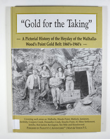 Marysville & District Historical Society
Book - Hardcover book, Gold for the Taking-A Pictorial History of the Heyday of the Walhalla-Wood's Point Gold Belt: 1860's-1960's, 2007
A pictorial history of the heyday of the Walhalla-Wood's Point gold belt in the 1860's-1960'sHardcover. The cover is a gold colour. The front cover has a photograph of a group of miners in front of the entry to a mine. On the top entry timber piece is a sign saying "Old Mine". The beginning of the wording is obscured by one of the miners standing in front of the entry. There is also an old mining trolley standing on tracks which lead into the mine.There is also an old gold mining dish sitting on a rock to the left of the entry into the mine.On the back cover is a photograph of Walhalla in modern times as well as a photograph of the publisher of this book. There is also a blurb about the publisher.Stamp of the Marysville & District Historical Society Inc / P.O. Box 22 / Marysville 3779gold, gold fields, gold mining, a1 mine settlement, aberfeldy, beardmore, black river group, coopers creek, donnellys creek, enochs point, fulton creek, gaffneys creek, gooleys creek, jamieson, jordan valley, kevington, knockwood, matlock, ten mile, walhalla, wood's point, history, victoria -
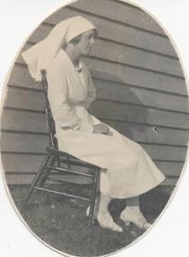 Phillip Island and District Historical Society Inc.
Photographs, Early 20th Century
5 photographs donated by Anne Oswin.332-01. Black & White photograph of a nurse seated outside a building - name unknown. 332-02. Black & White photograph of a lady standing by a garden - name unknown. 332-03. Black & White copy of a photograph/portrait of Mrs Olive Louise Justice (nee Grayden 16/11/1895 - ). Born at Newhaven, Phillip Island. 332-04. Black & White photograph of The Pyramid Rock, Phillip Island. 332-05. Black & White photograph of Ventnor Hall - opened 1915 and demolished 1970's.pyramid rock, olive louise justice, ventnor hall, anne oswin -
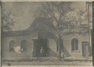 Bendigo Historical Society Inc.
Photograph - CHARLIE BUTTON'S STORE
black and white photo: large weatherboard building with central doorway, 4 arched windows and panelled doorway to right of photo. Two males standing in doorway. Trunks, prams, rocking chairs in front of photo, also cast iron cookware. MP 99 top right hand corner. On paper enclosed with photo : ' this large weatherboard building was Charlie Button's Secondhand Furniture Store at 204 Williamson Street next to Jones Miller's Store formerly Pickles' large rolling stock works' ( BHS Inc. )organization, business, charlie button's store -
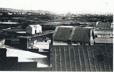 Bendigo Historical Society Inc.
Photograph - BENDIGO LANDSCAPE: LOOKING SOUTHWEST 1856, C 1856 ?
Black and white photograph of mines at Bendigo. 'Bendigo Tin' on side of building, 'Hay and corn store' at rear. Poppet heads and dams visible. In foreground - larger buildings, mostly weatherboard with corrugated iron or zinc rooves. Left centre appears to be stable with loft doors. Middle distance - many buildings with heaps of dirt/rock. Far distance - many small buildings ( houses ) chimneys, trees hills. James Lerk 11.2.2000 ' C 1856 looking southwest , Forest St. ( tin smith ) going to the right.place, landscape view, bendigo mining -
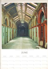 Bendigo Historical Society Inc.
Domestic Object - 2005 THE SPIRIT OF PLACE CALENDAR: JUNE PAGE
A 2005 page from the Spirit of Place Calendar that shows a large fairly recent photo taken by someone called Chris Kirwan of the old Bendigo Stock Exchange for the month of June. The building seems to be fairly worn out in this photo, I can only imagine what it looks like now in 2019. The back of the page shows many classic Victorian locations such as Hanging Rock. Lake Daylesford, etc. This seems to only be the page for the month of June and the other pages don't seem to be around here anymore. (or ever was)bendigo, history, general -
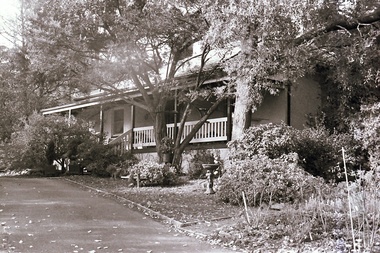 Southern Sherbrooke Historical Society Inc.
Photograph, Visit to Mt Heatherly, early 2000s
Photos of Mt Heatherly, an historical building in Belgrave, opposite Belgrave Lake Park. Address is Park Drive, on the corner of Waratah Ave. The house is now owned by Mrs Elizabeth Schneider, and was first constructed around 1881 by the first owner of the selection, Ormond Smith. It was made of hand-made bricks made on site, and a foundation of rock and stone. The original house may have had a corrugated iron roof. The original house forms part of the modern house. Photos taken in early 2000s by Susan Heywood-Downard. -
 Bendigo Historical Society Inc.
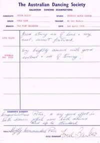
Document - PETER ELLIS COLLECTION: AUSTRALIAN DANCING SOCIETY BALLROOM DANCING EXAMINATION, 2nd April, 1978
Two The Australian Dancing Society Ballroom Dancing Examination sheets dated 2nd April 1978 for Peter Ellis for Old Time Ballroom. Teacher Mr Les Rankin, Bendigo Dance Centre. Dance was the Lita Waltz and Sparkle Two Step in the Gold Sash. Result Highly Commended, Pass. A.D.S. Examiner Fred Barber. The second sheet was the Hawaiin Waltz, Empress Waltz, Tango Rock, Charmaine and the Venetian Schottische in the Gold Medal Grade. Result Highly Commended, Pass. A.D.S. Examiner Fred Barber.entertainment, dance, ballroom dancing examinations, peter ellis collection, the australian dancing society ballroom dancing examinations, peter ellis, bendigo dance centre, les rankin, fred barber -
 Bayside Gallery - Bayside City Council Art & Heritage Collection
Map, Department of Crown Lands and Survey, Melbourne and Suburbs, City of Sandringham, 1917-1926
map, plan, foreshores, sndringham, hampton, beaumaris, cheltenham, department of lands and survey, cartographic material, borough of sandringham, moorabbin, black rock, street map, city of sandringham -
 Ballarat Tramway Museum
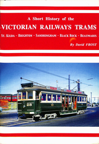
Book, David Frost, "A short history of the Victorian Railways Trams - St Kilda - Brighton - Sandringham - Black Rock - Beaumaris", May. 2006
Book - 20 pages + card covers, centre stapled titled "A short history of the Victorian Railways Trams - St Kilda - Brighton - Sandringham - Black Rock - Beaumaris". Covers have colour photographs on the outside. Page 11 has a map of the two tramways with the tram lines and features shown in red. Written by David Frost, published May 2006 by Tramway Publications. Edited by Dean Filgate. Provides details of the background of the tramways, Elwood depot fire, Sandringham depot, closure and an Epilogue Has details of the Author.trams, tramways, vr trams, elwood, st kilda brighton, sandringham, beaumaris -
 Bendigo Historical Society Inc.
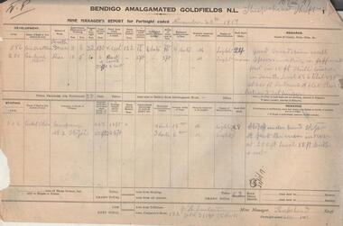
Administrative record - Bendigo Amalgamated Goldfields N.L. Mine Manager's Reports, 1917 - 1920
In 1917 Bendigo Amalgamated Goldfield Ltd was formed from the amalgamation of 35 companies with operations on the Garden Gully, Sheepshead, Deborah and Derby lines of reef hoping to increase profits of these existing operations through economies of scale. This was difficult to achieve as the shafts involved were spread throughout the goldfield. Diamond drilling and good geological practices were introduced (Pabst was Chief Geologist) leading to some exploration success. However costs were rising rapidly and in 1923 the directors, deciding that mining would soon become unprofitable, dissolved the company returning assets to the original vendors. J.H. Lenten, Mine Manager, received his second class Mine Manager's certificate in September, 1914 at an examination held at the Bendigo Law Courts. One hundred pages of fortnightly manager's reports for Bendigo Amalgamated Goldfields N.L., Sheepshead Shaft. Reports consist of two pages for each fortnight, signed by J.H. Lenten, Mine Manager. Dates of reports range from November 20th, 1917 to 5th May 1920. Categories reported on include: development, stoping, tons from tributors, tons Company's stone, plant and machinery, underground workings, number of rock drill shifts, firewood used, coal burnt, and general remarks. charcoal burnt., lifting waterbendigo, margaret roberts, , goldmining, bendigo amalgamated goldfields, sheepshead shaft, j.h. lenten, mine manager -
 The Beechworth Burke Museum
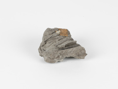
Geological specimen - Fossiliferous Mudstone, Unknown
This specimen was found in Cape Patterson, Vic. Cape Paterson is a cape and seaside village located near the town of Wonthaggi, 132 kilometres southeast of Melbourne, in the Bass Coast Shire of Gippsland, Victoria, Australia. These dark, fossiliferous Mudstones were deposited in slow-moving water associated with sedimentary basins & continental shelves. They are rich in carbon which makes them almost black. This is typical of an anoxic, reducing environment such as deep water or stagnant conditions where carbon-rich material would remain unoxidised during subsequent deposition & diagenesis. it has an imprint of a leaf in the rock itself, displaying the fossil of the plant. This specimen is unique due to the leaf impression within the stone itself. Imprint fossils are formed from an organism moving in some way, leaving behind a trace or track. These tracks are preserved when the clay/silt dries slowly and is covered by other sediment. Plants can also leave imprint fossils when they are covered by sediment. The leaf tissue degrades, leaving an imprint of where the leaf once was. This specimen is part of a larger collection of geological and mineral specimens collected from around Australia (and some parts of the world) and donated to the Burke Museum between 1868-1880. A large percentage of these specimens were collected in Victoria as part of the Geological Survey of Victoria that begun in 1852 (in response to the Gold Rush) to study and map the geology of Victoria. Collecting geological specimens was an important part of mapping and understanding the scientific makeup of the earth. Many of these specimens were sent to research and collecting organisations across Australia, including the Burke Museum, to educate and encourage further study.These dark, fossiliferous Mudstones were deposited in slow moving water associated with sedimentary basins & continental shelves. They are rich in carbon which makes them almost black. This is typical of an anoxic, reducing environment such as deep water or stagnant conditions where carbon rich material would remain unoxidised during subsequent deposition & diagenesis. FOSSILIFEROUS MUDSTONE / Locality: Cape Patterson, Victoria | Descriptive catalogue / Pg 27 No 95 / "Grey Clay, / Cape Paterson with leaf impressions' / 15/4/21 C. William /mudstone, cape patterson, leaf imprint, fossilised leaf, fossiliferous mudstone