Showing 3627 items
matching landscape
-
 Rutherglen Historical Society
Images
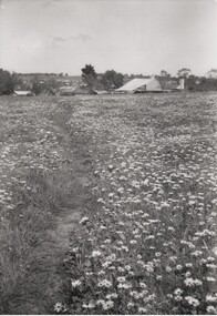
One of a collection of photographs from the Florence Iggsten EstateBlack and white photograph of a field of flowers with buildings, including a large shed or barn, in the background.landscape, florence iggsten -
 Buninyong & District Historical Society
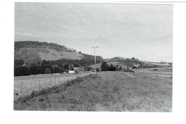
Photograph - Original B/W Photograph, B&DHS member Clive Brooks, Mount Buninyong, eastern slopes from Yendon No.2 Rd, 9 April 1994
B/W photo Mount Buninyong, eastern slopes from Yendon No.2 Rd. across fields.landscape, mt. buninyong -
 Buninyong & District Historical Society
Photograph - B/W photograph, Mr. Clive J. Brooks, North Eastern slopes of Mount Buninyong from Yendon Road, April 1994
Tree cover on Mount Buninyong and agricultural use of land in 1994 clearly visible.Natural and agricultural record of Mount Buninyong in late 20th centuryBlack and white photograph of the North Eastern slopes of Mount Buninyong from Yendon No. 1 Road. Tree cover and agriculture use clearly visible.mount buninyong, landscape -
 Brimbank City Council Art Collection
Photograph, Robert Pointon, Twin Pines, 1988
Local LandscapeEast of Fairbiarn Road, South Sunshine, looking east - AR0002landscape, photograph -
 Brimbank City Council Art Collection
Photograph, Kororoit Creek, Opposite Deer Park Hotel, 1994
Local LandscapeOpposite Deer Park Hotel, West Side Kororoit Creek looking East AR0108photograph, landscape -
 Federation University Art Collection
Katherine Douglas, 'The Sheer Scale'by Katherine Douglas, 2022
katherine douglas, landscape -
 Glenelg Shire Council Cultural Collection
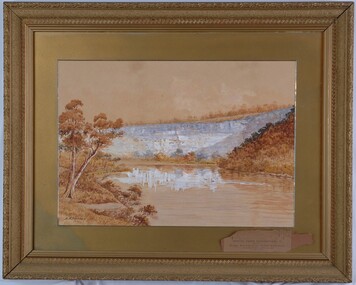
Painting, A.S. Murray, Scene on the River Glenelg, c. 1894
Art Collection Previously located in History HouseThe painting depicts a large body of water surrounded by hills. The body of water extends from the front right corner through to the centre of the work. Predominately depicted in shades of brown, the body of water has a white centre with three birds (swans) sitting on the surface. In the foreground to the left of the water is a riverbank with a large brown tree. The background consists of a large blue/grey hillside and brown cloudless sky. The work has a gilded ornate frame with a gold mount and exposed canvas.Front: A.S. Murray Back: W.HAMER, 189 Sturt Street, Ballarat, VICTORIA BUILDINGS, OPPOSITE CITY FIRE BRIGADElandscape, glenelg river -
 Buninyong & District Historical Society
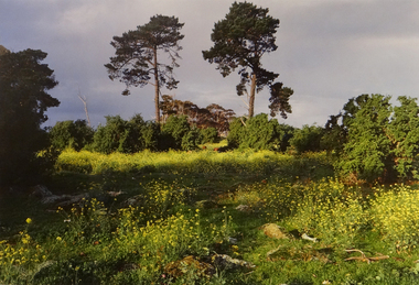
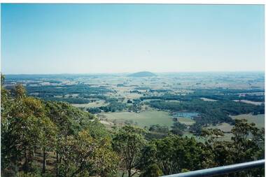
Photograph - Colour photograph, Mt. Warrenheip
Distant view of Mt. Warrenheip Lookout tower from Mt. Buninyong Tower 1995The view of Mt. Warrenheip shows the rural landscape from Mt. Buninyong in the late twentieth centuryDistant view of Mt. Warrenheip looking North from Mt. Buninyong Lookout TowerFrom the Mt. Buninyong Tower, Feb 1995mt. warrenheip, landscape -
 Darebin Art Collection
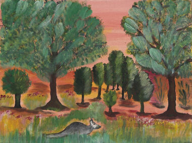
Painting, Aunty Frances Gallagher, Grazing Kangaroo, 2010
kangaroo, landscape -
 Darebin Art Collection
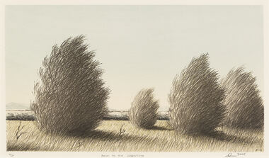
Print, Adam Nudelman, Down to the Water Line, 2008
trees, landscape -
 Darebin Art Collection
Painting, Aunty Gwen Garoni, Regrowth after the fires, 2010
landscape, bushfires -
 Darebin Art Collection
Painting, Aunty Gwen Garoni, Regrowth in the Yarra Valley, 2011
landscape, yarra valley -
 Ringwood and District Historical Society
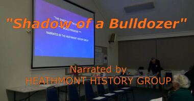
Mixed media - Video, RDHS Guest Speaker Presentation - "Shadow of a Bulldozer" - Heathmont History Group
Digitised video (4.05GB). Duration: 40 minutes. Recorded June, 2019. (Video is available for viewing at Ringwood & District Historical Society Archives by appointment)Presentation: Members of Heathmont History Group address a meeting of RDHS with a reading of a play telling of destruction of orchards in the 1950s/60s and the resistance of change to the landscape and family lifestyles with the onset of residential developments. -
 Ballarat Heritage Services
Photograph - Photograph - Colour, Clare Gervasoni, Treed road behind St Laurence O'Toole Catholic Church, Sandon, 2017, 16/07/2017
St Laurence O'Toole church and cemetery is located in a rural setting at 801/821 Creswick-Newstead Rd, Sandon. Originally a small wooden school (22’x14’) was erected in Sandon by Father Patrick Smyth (who was involved in the Eureka Stockade movement) in 1859. It was also used for Mass and became known as a chapel. In June 1882 tenders were called for the construction of a brick Church by the Castlemaine architect, T.F. Kibble, and it was built at a cost of 1000 pounds. The church was blessed by Archbishop Goold on 06 May 1883 and dedicated to St Laurence O'Toole. The brick building demonstrates original design qualities of a Victorian Rudimentary Gothic style, including the steeply pitched, parapet gable roof form, together with a central steeply pitched, gabled porch that projects slightly from the main gable end. Other intact qualities include the exposed brick wall construction, lapped galvanised corrugated iron roof cladding, minor gabled porch at the rear, small ventilation dormers nearby the roof ridgeline, series of stone steps that lead to the central porch with its double pointed door opening and vertical boarded doors, simple rose window in the main gable end, pointed windows, brick buttresses with double lower copings, and the light masonry detailing (the banding marking the floor level within, buttress copings, window and door surrounds and quoins, and the drip moulds).(Shire of Mount Alexander: Heritage Study of the former Shire of Newstead, 2000) The visually connected cemetery demonstrates important visual qualities formed by the regular rows of graves and cemetery architecture, and the grassed and treed rural landscape. It is a rare and substantially intact example of a Victorian Catholic Church with a cemetery in its churchyard. Many headstones and cemetery architecture, date from the 19th century and represent some fine examples of masonry craftsmanship. Some refurbisments occurred during the 1940s and in 2002 a major restoration project was undertaken from roof to footings, by a dedicated band of volunteers and trades people. Work was completed mid 2003 and in November 2003 St Laurence’s was re-dedicated with the celebration of Mass and a picnic tea. Colour photograph of bushland behind a church at Sandon, Victoria.sandon, sandon cemetery, st laurence o'toole catholic church, sandon, landscape, road -
 Eltham District Historical Society Inc
Photograph, Looking east along Nerreman Gateway towards intersection with Ryans Road, Eltham, c.1992, 1992c
Gordon Ford landscape design at entrance to Nerreman Gateway.Roll of 35mm colour negative film, 7 strips Fuji 100eltham, gordon ford, nerreman gateway, nerreman park estate, ryans road, streets -
 Eltham District Historical Society Inc
Photograph, Looking south along Ryans Road near intersection with Nerreman Gateway, Eltham, c.1992, 1992c
Gordon Ford landscape design at entrance to Nerreman Gateway.Roll of 35mm colour negative film, 7 strips Fuji 100eltham, gordon ford, nerreman gateway, nerreman park estate, ryans road,streets -
 Eltham District Historical Society Inc
Photograph, Looking west up Nerreman Gateway from intersection with Ryans Road, Eltham, c.1992, 1992c
Gordon Ford landscape design at entrance to Nerreman Gateway.Roll of 35mm colour negative film, 7 strips Fuji 100eltham, gordon ford, nerreman gateway, nerreman park estate, ryans road,streets -
 Eltham District Historical Society Inc
Photograph, Looking north along Ryans Road near intersection with Nerreman Gateway, Eltham, c.1992, 1992c
Gordon Ford landscape design at entrance to Nerreman Gateway.Roll of 35mm colour negative film, 7 strips Fuji 100eltham, gordon ford, nerreman gateway, nerreman park estate, ryans road,streets -
 Eltham District Historical Society Inc
Photograph, Looking east along Nerreman Gateway towards intersection with Ryans Road, Eltham, c.1992, 1992c
Gordon Ford landscape design at entrance to Nerreman Gateway.Roll of 35mm colour negative film, 7 strips Fuji 100eltham, gordon ford, nerreman gateway, nerreman park estate, ryans road,streets -
 Eltham District Historical Society Inc
Photograph, Looking west up Nerreman Gateway from intersection with Ryans Road, Eltham, c.1992, 1992c
Gordon Ford landscape design at entrance to Nerreman Gateway.Roll of 35mm colour negative film, 7 strips Fuji 100eltham, gordon ford, nerreman gateway, nerreman park estate, ryans road,streets -
 Eltham District Historical Society Inc
Photograph, Looking east along Nerreman Gateway towards intersection with Ryans Road, Eltham, c.1992, 1992c
Gordon Ford landscape design at entrance to Nerreman Gateway.Roll of 35mm colour negative film, 7 strips Fuji 100eltham, gordon ford, nerreman gateway, nerreman park estate, ryans road,streets -
Creswick Campus Historical Collection - University of Melbourne
Slide - Collection of over 1000 slides of trees, landscapes, etc, K.J. Simpfendorfer, Photographic slides
This is a collection of over 1000 slides of trees, landscapes, etcPhotographic slides -
 Kew Historical Society Inc
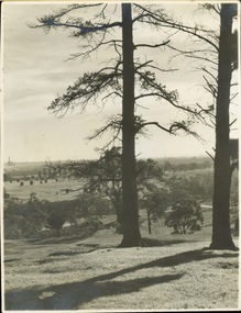
Photograph - Golf course viewed from East Kew, 1940s?
Landscape photograph of Kew and Fairfield. Undated but possibly 1930s.View of Latrobe Course from the Kew side of the River Yarra. River in middle foreground. Aged pine tree central foreground. Inscribed reverse: "M Holmes"kew (vic.), latrobe golf course -
 Kiewa Valley Historical Society
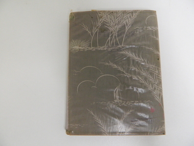
Book - English Reader, The Victorian Readers Fifth Book, 1940
This book was supplied by the Victorian Education Department for all Grade 5 students at Government schools. Each student had one including the local family who passed it on to another family member. Books were covered to protect them. In this case a stiff, dull plastic.Historical: Used by grade 5 students in Victorian Government Schools. Provenance: Used and handed down to family members in Tawonga where they lived and went to school.Pale coloured pinkish plastic with white landscape picture in white on it covers the hard covered book. Parts of the plastic have small tears and is wrinkled. Inside front cover: Ann Louden On title page: G. Daviesprimary school. education. victorian education department. tawonga. davies. louden. reader. -
4th/19th Prince of Wales's Light Horse Regiment Unit History Room
Framed Print, H S Power ROI SAP, Leaders of the Australian Light Horse Jordan Valley, August 1918
Monochrome landscape framed print of 11 senior officers of Australian Light Horse at Jordan Valley in August 1918. In glass fronted wooden frameprint, light horse -
 Glen Eira Historical Society
Album - Album page, Neerim Road, Circa 1972
This photograph is part of the Caulfield Historical Album 1972. This album was created in approximately 1972 as part of a project by the Caulfield Historical Society to assist in identifying buildings worthy of preservation. The album is related to a Survey the Caulfield Historical Society developed in collaboration with the National Trust of Australia (Victoria) and Caulfield City Council to identify historic buildings within the City of Caulfield that warranted the protection of a National Trust Classification. Principal photographer thought to be Trevor Hart, member of Caulfield Historical Society. Most photographs were taken between 1966-1972 with a small number of photographs being older and from unknown sources. All photographs are black and white except where stated, with 386 photographs over 198 pages. "Edenkillie" was the home of Frederick Jowett, Caulfield's shire secretary and town clerk from 1887 to 1921. The Outer Circle Railway's Oakleigh section opened 1890 and closed 1895. Victorian Heritage database (as of 26/10/2021) HO45 Edenkillie https://vhd.heritagecouncil.vic.gov.au/places/35545 "Edenkillie" at 37 Neerim Road, Glenhuntly, is a substantial two storeyed polychrome brick villa, built for Frederick Jowett, municipal secretary, in 1890. It has aesthetic, historical and social significance. "Edenkillie's" aesthetic value derives from its survival as a substantially intact example of a common villa form expressed in polychrome brickwork. Its historical significance lies in its association with Frederick Jowett, Shire of Caulfield secretary and town clerk for over three decades. Its social significance is derived from the building's ability to demonstrate the kind of lifestyle which a local government administrator could enjoy during the Land Boom.Page 145 of Photograph Album with four landscape photographs from Neerim Road: two photographs of No 37 and two of the Outer Circle Railway Reserve.Handwritten: Neerim Road [top left] / 37 NEERIM ROAD 1OCT 1972 [under top left photo] / 37 NEERIM RD 1 OCT 1972 [under top right photo] / OUTER CIRCLE RAILWAY RESERVE MURRUMBEENA [under bottom left photo] / 145 [bottom left]trevor hart, neerim road, murrumbeena, caulfield, edenkillie, glen huntly, polychrome brick, mansions, frederick jowett, town clerks, shire of caulfield, outer circle railway, railways, parks and reserves, outer circle railway reserve, cast iron work, verandahs, balconies -
 Federation University Historical Collection
Book, Trav Munro, Through the Lens: A Photographic Journey Through the University's Historic Landscapes, 2016, 2016
Brown soft covered books featuring beautiful photographs featuring Federation University's historic landscape, and items from the Federation University Historical Collection. federation university, federation university historical collection, historic campuses, enrolment book, ballarat east plan, ballarat schhol of mines associates boards, assay kilns, stained glass, former ballarat gaol, smb campus, leather tools, camp st, arts academy, former ballarat post office, post office gallery, mace, federation university mace, former stawell school of mines, jacarandah restaurant, ballarat mechanics' institute