Showing 1859 items
matching the rock
-
 Kiewa Valley Historical Society
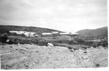
11 Black and White photographs of the Rocky Valley area, c1948
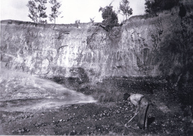
In October 1947 construction was commenced on the erection of the workmen's camp at Rocky Valley. Also in 1947 construction of a stream diversion was commenced to allow excavation to commence for the dam wall. In the summer of 1948/49, stripping of the foundation area on both sides of the river was carried out. Weather conditions were not always favourable during the construction, particularly 1955/56 summer, and work would have to cease each year for the winter season due to the severe conditions. The dam is a earth and rock fill structure with a height of about 30.5 metres and crest length 518.16 metres and was completed in March, 1959.These photographs show the type of terrain in the area prior to the construction and filling of Rocky Valley Dam. Also of interest is the type of accommodation provided for those working on the construction and the early cranes available in the 1940/50's. Of historical importance to understand the conditions in the early construction of the Kiewa Hydro Electric SchemeEleven small black and white photographsPhoto No. 1 - on the back, printed in ink"Rocky Valley - New Mess & offices Dec. 1948". In pencil '14 on the back Photo No. 2 - on the back, printed in ink "Rocky Valley Camp. October 1948". Also stamped on the back "998L" Photo No. 3 -on the back, printed in ink "Rocky Valley Hostel October 1948". Also stamped on the back '998L' Photo No. 4 - on the back, printed in ink "Spion Kopje from bedroom window. October 1948". Stamped on the back '998L'. Photo No. 5 - on the back, printed in ink "Rocky Valley Basin Dec. 1948." In pencil on back, 14. Photo No. 6 - on the back, printed in ink "Site of Wall for Rocky Valley Dam Dec. 1948". In pencil on back, 14. Photo No. 7 - On the back, printed in ink "Commencing of Diversion Tunnel Rocky Valley December 1948". In pencil on back, 14. Photo No. 8 - on the back, printed in ink "One of the two electric cranes at Rocky Valley December 1948". In pencil on back, 14. Photo No. 9 - on the back, printed in ink "'Rapier' (H.Y.) electric crane Rocky Valley December 1948". In pencil on back, 14 . Photo No. 10 - on the back, printed in ink " Pretty Valley Pump line construction Mt. Cope in Background Nov 1948. Circular stamp with the words 'print by Wilson White Albury' in the circle. Photo No. 11 - on the back, printed in ink "Stringing cable on Ruined Castle October 1948. Same stamp as No. 10. In pencil '31'. rocky valley; pretty valley; ruined castle; bogong high plains; kiewa hydro electric scheme -
 Warrnambool and District Historical Society Inc.
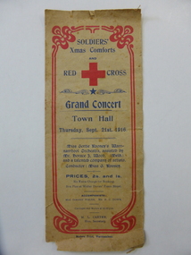
Document, Soldier's Xmas comforts, 1016
This is a program of a concert organized by the Soldiers’ Christmas Comforts Group and the Red Cross in Warrnambool to raise funds for the soldiers on active service in World War One. The concert was held in the Warrnambool Town Hall in September 1916 and featured a Melbourne artist, Horace Wood, who gave several violin solos and the local Warrnambool orchestra of Miss Gertrude Rooney. The Rooneys were early settlers in the Dennington area and had the property, ‘White Rock’ in Dennington and a produce store in Warrnambool. Miss Gertrude Rooney was an accomplished musician and was prominent in musical circles in Warrnambool during the first half of the 20th century. This program is of interest as an example of the fund raising activities in Warrnambool during World War One and of the type of entertainment offered at concerts at that time. There are many well-known names listed among the orchestra members at the back of the program. This is a sheet of buff-coloured paper folded in two to make four pages. The front page has an ornate red edging and there is dark blue printing on the front and back pages. The front page has a large Red Cross emblem The inside two pages have the printed program of concert items in black print. There are also advertisements for local Warrnambool businesses. The edges of the program are torn and ragged. world war one, warrnambool in world war one, gertrude rooney, musical entertainments in early 20th century, warrnambool -
 Orbost & District Historical Society
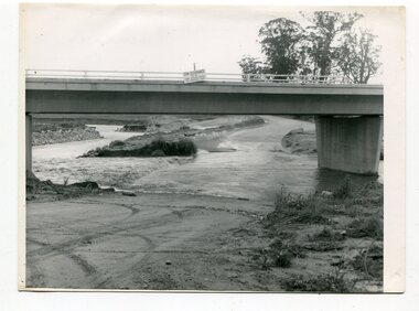
black and white photographs, October 22 1976
The road to Marlo was cut by flood waters from the Snowy River in two places. The road was closed when water flowed over Gilbert's Gulch (3243.1) The Snowy River broke its banks and flooded surrounding Orbost, Marlo, Lochend and Jarrahmond were isolated. The river bank at the bridge site was broken and filled with earth and rock fill. (3243.2) The new Snowy River Bridge was nearing completion when the river rose 7.2 metres causing erosion on the eastern bank. (3243.7) Contractors involved in the construction of the Princes Freeway and bridge were delayed by the flood waters. (3243.8) The 1976 flood at Orbost was a significant event which delayed the construction of the current Snowy River Road Bridge.These photographs record that event.Nine black / white photographs of flood waters across roads. orbost-flood-1976 snowy-river-bridge marlo-road-flood-1976 gilbert;s-gulch-flood -
 Australian National Surfing Museum
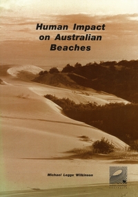
Document, Human Impact on Australian Beaches (Results from SOS95 Beach Survey), 1/5/1996 (estimated)
Human Impacts on Australian Beaches was a landmark environmental study which provided a 'snapshot' of the health of 1612 beach areas around Australia. This nationwide study (which built on the success of the 1994 State of Our Surf Report) was put together by the Surfrider Foundation Australia with the support of more then 340 individuals and 70 organisations around Australia. The report was authored by surfer/environmentalist/artist Michael Legge-Wilkinson from Newcastle, New South Wales. Human Impacts was launched officially by Peter Garrett, leader of Australian rock band Midnight Oil at the Bondi Pavilion, Bondi Beach in May 1996.Human Impacts built on the success of the 1994 State Of Our Surf Report, released by the Surfrider Foundation Australia in 1994. Human Impacts was the first major report to specifically examine the environmental health of 1612 of Australia's beaches. A limited 500 copies of this report were produced, the majority of which went to education institutions, libraries, community groups and government departments. The report generated national and international media interest with the BBC London reporting on its findings in the week after its launch.Beach Environmental Report. 168 page report which examines the health of 1612 beach areas around Australia. Sepia cover featuring a photograph of endangered sanddunes at Stockton Bight, north of Newcastle. 168 pagesSepia cover, Surfrider Foundation logo on report coverbeach, surfrider foundation australia, human impacts on beaches, sos95, michael legge wilkinson, coastal development, beach pollution -
 Bendigo Historical Society Inc.
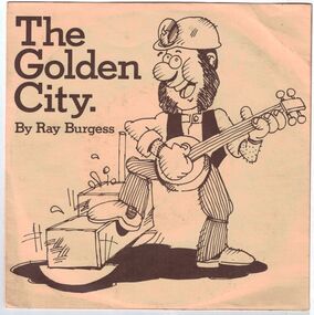
Mixed media - The Golden City Record and Songs, 1981
Australian musician and television presenter, Ray Burgess, shot to the top of Australia’s fledgling pop-rock scene following a successful appearance on television’s talent show, New Faces (the 20th century equivalent of Australian Idol). It was 1970 and Ray soon became a founding member of popular show band, Red Time, touring Australia for several years before the band was signed up as backing band to then-King of Pop, Johnny Farnham. An accomplished singer in his own right, Ray undertook a solo career in 1974 and his very first recording, ''Touch Me'', became a huge Australian hit. Jane Bretherton Collection: The Golden City Record and Songs - 45 inch record and jacket. On the Front "The Golden City by Ray Burgess" On the Rear " The Golden City and Words to the lyrics, Lyrics reproduced by kind permission of Leeds Music. Words and Music: Don Mudie, Vocal: Ray Burgess, Production: Don Mudie, Copyright: Leeds Music." There are two tracks on the record: "The Golden City" and "Rachel's Song".history, bendigo, ray burgess, rachel's song, the golden city song -
 Bayside Gallery - Bayside City Council Art & Heritage Collection
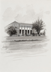
Work on paper - ink and watercolour, Annette Meikle, St Vincent de Paul's Children's Home, 1977
In 1977, artist Annette Meikle undertook a commission to illustrate a book recording stories of places and people in the Bayside area. It was published in 1978 as Sandringham Sketchbook, with text by Elizabeth Waters. The sketches were intended to record remaining examples of Bayside’s early architecture and environment, as well as reflect newer architectural changes. Meikle went on to donate 22 of these sketches to Bayside City Council in 2003. This red brick building in Balcombe Road, Black Rock, was constructed in the inter-war period (1939) as a holiday home for State wards and neglected children who were placed in the care of the Sisters of Mercy.Annette Meikle, St Vincent de Paul's Children's Home 1977, ink and watercolour, 35.7 x 25.6 cm. Bayside City Council Art and Heritage Collection. Donated by the artist, 2003annette meikle, sandringham sketchbook, elizabeth waters, st vincent de paul's children's home, balcombe road, black rock, sisters of mercy -
 Bendigo Military Museum
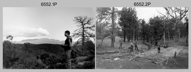
Photograph - 4th Field Survey Squadron Adventurous Training, Wilpena pound, Flinders Ranges, SA, 1989
This is a set of 43 photographs of a 4th Field Survey Squadron adventurous training held at Wilpena pound, in the Flinders Ranges of South Australia in 1989. It is evident the training focussed on teamwork, leadership, abseiling, rock climbing, field craft and living off the land survival skills. Elements from units of the Army Reserve also participated in the training. In this photo set, one of 4th Field Survey’s sections participated in abseiling and trekked to the highest mountain in the Flinders Ranges – St. Mary’s Peak. Refer to items 6553.56P for additional colour photographs taken during the adventurous training exercise.This is a set of 43 photographs of 4th Field Survey Squadron personnel undergoing adventurous training held at Wilpena pound, in the Flinders Ranges of South Australia in 1989. The black & white photographs are on 35mm negative film and are part of the Army Survey Regiment’s Collection. The photographs were scanned at 96 dpi. .1) - Photo, black & white, 1989. L to R: SGT Laurie Justin, SGT Stu Symonds. .2) - Photo, black & white, 1989. L to R: SGT Stu Symonds, CPL Roger Graf, SSGT Max Coletti, SPR Cheryl Deluca-Cardillo, SPR Andrew Quin. .3) & .4) - Photo, black & white, 1989. Wilpena Pound topography. .5) - Photo, black & white, 1989. SGT Stu Symonds. .6) - Photo, black & white, 1989. Abseiling ropes and equipment. .7) to .16) - Photo, black & white, 1989. Abseiling activities, unidentified soldier. .17) to .18) - Photo, black & white, 1989. Abseiling activities, CPL Michelle Griffith. .19) - Photo, black & white, 1989. L to R: unidentified (x5), SGT Mick Hogan, unidentified (x3). .20) - Photo, black & white, 1989. L to R: CPL Roger Graf, CPL Michelle Griffith, SPR Cheryl Deluca-Cardillo, SGT Laurie Justin, SSGT Max Coletti, SPR Andrew Quin. SGT Stu Symonds. .21) - Photo, black & white, 1989. L to R: unidentified (x2), SGT Stu Symonds. .22) & .23) - Photo, black & white, 1989. Wilpena Pound topography. .24) - Photo, black & white, 1989. SSGT Max Coletti. .25) - Photo, black & white, 1989. SSGT Max Coletti, SPR Cheryl Deluca-Cardillo, SGT Stu Symonds. .26) - Photo, black & white, 1989. SGT Stu Symonds. .27) - Photo, black & white, 1989. L to R: CPL Michelle Griffith, SPR Cheryl Deluca-Cardillo, SSGT Max Coletti, SGT Laurie Justin, SPR Andrew Quin, CPL Roger Graf, SGT Stu Symonds. .28) &.29) - Photo, black & white, 1989. Wilpena Pound topography. .30) - Photo, black & white, 1989. SGT Stu Symonds. .31) - Photo, black & white, 1989. CPL Michelle Griffith. .32) - Photo, black & white, 1989. L to R: CPL Michelle Griffith, SGT Stu Symonds, SSGT Max Coletti, SGT Laurie Justin. .33) - Photo, black & white, 1989. L to R: CPL Michelle Griffith, SGT Stu Symonds, CPL Roger Graf (standing), SSGT Max Coletti, SGT Laurie Justin. .34) - Photo, black & white, 1989. L to R: SGT Stu Symonds, CPL Michelle Griffith, CPL Roger Graf (standing), SSGT Max Coletti, SGT Laurie Justin. .35) to .37) - Photo, black & white, 1989. Wilpena Pound topography. .38) - Photo, black & white, 1989. SPR Cheryl Deluca-Cardillo. .39) - Photo, black & white, 1989. L to R: CPL Michelle Griffith, SGT Stu Symonds, SPR Andrew Quin, SGT Laurie Justin. .40) &.41) - Photo, black & white, 1989. Wilpena Pound topography. .1P to .43P – There are no personnel identified. ‘1989 ADV TRAINING’ annotated on negatives sleeve.royal australian survey corps, rasvy, 4 fd svy sqn -
 Bendigo Military Museum
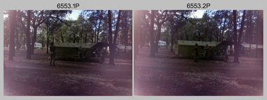
Photograph - 4th Field Survey Squadron Adventurous Training, Wilpena pound, Flinders Ranges, SA, 1989
This is a set of 55 photographs of a 4th Field Survey Squadron adventurous training held at Wilpena pound, in the Flinders Ranges of South Australia in 1989. It is evident the training focussed on teamwork, leadership, abseiling, rock climbing, field craft and living off the land survival skills. Elements from units of the Army Reserve also participated in the training. In this photo set, one of 4th Field Survey’s sections participated in abseiling and trekked to the highest mountain in the Flinders Ranges – St. Mary’s Peak. Refer to item 6552.43P for black & white photographs taken during the adventurous training exercise.This is a set of 55 photographs of 4th Field Survey Squadron personnel undergoing adventurous training held at Wilpena pound, in the Flinders Ranges of South Australia in 1989. The colour photographs are on 35mm negative film and are part of the Army Survey Regiment’s Collection. The photographs were scanned at 96 dpi. .1) & 2)- Photo, colour, 1989. Base camp. WO1 Bill Griggs 2nd from left, remainder unidentified. .3) - Photo, colour, 1989. Old homestead inside Wilpena Pound. SPR Cheryl Deluca-Cardillo, 2nd from left, remainder unidentified. .4) - Photo, colour, 1989. Wilpena Pound topography. .5) - Photo, colour, 1989. Abseiling activities, unidentified personnel. .6) & .7) - Photo, colour, 1989. Flinders Ranges topography. .8) - Photo, colour, 1989. Abseiling activities. L to R: SSGT Max Coletti, SGT Stu Symonds. .9) - Photo, colour, 1989. Abseiling activities, unidentified personnel. .10) - Photo, colour, 1989. Flinders Ranges topography. .11) - Photo, colour, 1989. Abseiling activities. L to R: unidentified, CPL Michelle Griffith, SGT Stu Symonds. .12) - Photo, colour, 1989. Abseiling activities. L to R: unidentified, SPR Andrew Quin, SGT Laurie Justin, SGT Stu Symonds. .13) - Photo, colour, 1989. Abseiling activities. L to R: SGT Stu Symonds SGT Laurie Justin. .14) - Photo, colour, 1989. Abseiling activities. L to R: unidentified, SGT Stu Symonds. .15) - Photo, colour, 1989. Abseiling activities. SGT Laurie Justin. .16) - Photo, colour, 1989. Abseiling activities. SGT Stu Symonds. .17) & .18) - Photo, colour, 1989. Abseiling activities. SPR Cheryl Deluca-Cardillo. .19) - Photo, colour, 1989. Abseiling activities. L to R: SPR Cheryl Deluca-Cardillo, unidentified. .20) - Photo, colour, 1989. Abseiling activities. SSGT Max Coletti. .21) - Photo, colour, 1989. Abseiling activities. SPR Andrew Quin. .22) - Photo, colour, 1989. Abseiling activities. CPL Michelle Griffith. .23) - Photo, colour, 1989. Abseiling activities. CPL Michelle Griffith. .24) - Photo, colour, 1989. Flinders Ranges topography, unidentified personnel. .25) - Photo, colour, 1989. Flinders Ranges topography, unidentified SGT. .26) to .30) - Photo, colour, 1989. Flinders Ranges topography. .31) - Photo, colour, 1989. Flinders Ranges topography, unidentified personnel. .32) & .33) - Photo, colour, 1989. Flinders Ranges topography. L to R: unidentified, CPL Michelle Griffith, SGT Stu Symonds, CPL Roger Graf, SSGT Max Coletti, SGT Laurie Justin. .34) - Photo, colour, 1989. St. Mary’s Peak. L to R: unidentified, CPL Michelle Griffith, CPL Steve Nokes, SGT Stu Symonds. .35) - Photo, colour, 1989. St. Mary’s Peak. SGT Stu Symonds. .36) & .37) - Photo, colour, 1989. St. Mary’s Peak. CPL Steve Nokes. .38) - Photo, colour, 1989. Flinders Ranges topography. .39) - Photo, colour, 1989. St. Mary’s Peak. SGT Laurie Justin. .40) - Photo, colour, 1989. St. Mary’s Peak. SPR Cheryl Deluca-Cardillo. .41) - Photo, colour, 1989. St. Mary’s Peak. SPR Andrew Quin. .42) - Photo, colour, 1989. Flinders Ranges topography, SGT Stu Symonds. .43) - Photo, colour, 1989. Social activities. L to R: unidentified (x6), CPL Perry Langeberg, SGT Laurie Justin. .44) - Photo, colour, 1989. Social activities. L to R: CPL Perry Langeberg, SGT John Zuringer, SGT Laurie Justin, SGT Mick Hogan, unidentified, SGT Stu Symonds. .45) - Photo, colour, 1989. Social activities. L to R: unidentified (x6), CPL Perry Langeberg, SGT John Zuringer. .46) - Photo, colour, 1989. Social activities. L to R: CPL Jamie McRae, SGT Laurie Justin, SGT Mick Hogan, unidentified, SGT Stu Symonds, SPR Cheryl Deluca-Cardillo, WO1 Bill Griggs. .47) - Photo, colour, 1989. Social activities. L to R: SGT Laurie Justin, unidentified, CPL Steve Nokes, SGT Stu Symonds, SPR Cheryl Deluca-Cardillo, WO1 Bill Griggs, unidentified (x2). .48) - Photo, colour, 1989. Social activities. L to R: CPL Steve Nokes, WO1 Bill Griggs, SPR Cheryl Deluca-Cardillo, unidentified (x2), CPL Steve Ellis, CPL Michelle Griffith, SGT Gill Park. .49) - Photo, colour, 1989. Social activities. L to R: CPL Perry Langeberg, SGT John Zuringer, CPL Jamie McRae, SGT Laurie Justin, SGT Mick Hogan, unidentified, SGT Stu Symonds. .50) - Photo, colour, 1989. Sheep cooking in fire pit. L to R: WO2 Peter Symmans, unidentified (x5), CPL Steve Ellis. .51) - Photo, colour, 1989. Sheep cooking in fire pit. L to R: WO2 Peter Symmans, unidentified. .52) - Photo, colour, 1989. Sheep cooking in fire pit. Unidentified personnel. .53) - Photo, colour, 1989. Cooked sheep removed from fire pit. L to R: unidentified. WO2 Peter Symmans, unidentified. .54) - Photo, colour, 1989. Cooked sheep removed from fire pit. L to R: CPL Michelle Griffith, SGT Gill Park, unidentified, SSGT Max Coletti, unidentified, SPR Cheryl Deluca-Cardillo. .55) - Photo, colour, 1989. Cooked sheep removed from fire pit. L to R: unidentified, CPL Michelle Griffith, WO2 Peter Symmans..1P to .55P – There are no personnel identified. ‘1989 ADV TRAINING’ annotated on negatives sleeve.royal australian survey corps, rasvy, 4 fd svy sqn -
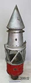 Flagstaff Hill Maritime Museum and Village
Functional object - Marine Navigation Light, Early 20th century
Breakwater navigation lights are placed at the end of the breakwaters to warn incoming vessels of the end of the structure, as a marine safety measure. The subject item was such a light believed to have been placed at the end of Warrnambool's breakwater around 1915 when it was extended. The light had remained in place for many years until it was probably removed when the structure was undergoing rock armouring repairs to the end of the breakwater in 1975. The light had been placed in a council storage shed probably from the time when the structure was undergoing these repairs in 1975. In 2014 the light was removed from the storage shed and donated to Flagstaff Hill museum. History: Warrnambool breakwater plans were drawn up by 1874 and approval was given for preliminary construction work to start but when the money ran out, the works stopped. With a number of quick changes of government the “Warrnambool” breakwater project was kicked from one Victorian state government to another. Then finally in 1879, the eminent British harbour engineer Sir John Coode was asked to design a breakwater. His first design was for a 1800 feet long structure but that was scaled back to 900 feet and construction finally began in 1884. This structure was attributed in causing major siltation of Lady bay, as a consequence the breakwater was again extended in 1915. In 1975, the rock armouring at the end of the breakwater was added but by 1979 another impact study was calling for the breakwater to be removed altogether. The Heritage Council Victoria, regard the Warrnambool breakwater is of historical significance to the state as one of the most important maritime engineering projects that was undertaken in Victoria during the late nineteenth century. The light is also as part of this structure regarded as a significant item of historical interest.Marker light or navigation light. Round light stand with conical top piece (2 separate pieces). Metal base painted red, clear glass middle section enclosed by metal frame, metal cone shaped top section painted silver. Electrical wiring can be seen inside centre section. Pole that light would have been on to elevate it is missing.Has metal plate screwed onto side of base engraved "23". flagstaff hill, warrnambool, shipreck coast, flagstaff hill maritime museum, maritime museum, great ocean road, warrnambool breakwater, marker light, naviagtion light, breakwater navigation light -
 City of Moorabbin Historical Society (Operating the Box Cottage Museum)
Clothing - Clothing, City of Moorabbin Tie, Circa 1960s
The City of Moorabbin existed from 1934 until 1994. Henry Dendy's Special Survey in 1841 of 5,120 acres in the Parish of Moorabbin , extended from Port Phillip Bay , then East to Boundary Road, South to South Road and North to North Road and became known as Brighton. 1859 Brighton became a Borough with its boundary Thomas Street ,and Bluff Road. In 1862 The Moorabbin Roads Board was formed and the extended area now included Cheltenham, Hampton, Sandringham, Black Rock, Beaumaris, Mentone and Mordialloc .and Little Brighton became known as Bentleigh. In 1871 the area became known as The Shire of Moorabbin. Gradually the area was separated into The Borough of Sandringham 1917, ( Black Rock, Beaumaris , Sandringham and Hampton ) Borough of Mentone and Mordialloc 1920, ( Parkdale ). In 1934 The City of Moorabbin was established for the area from South East corner of Thomas Street and North Road , East to Warrigal Road, Clayton Road, Kingston Road , Lower Dandenong Road, then South along Nepean Highway to Balcombe Road and along Bluff Road, Cummins Road, Nepean Highway, Thomas Street to North Road In the 1994 Amalgamation of Councils the City of Moorabbin was divided between the new City of Kingston in the South ( from South Road) and the new City of Glen Eira to the North . It was the largest Municipality in Victoria with a population of 118,865 in 1974This tie c 1960 is a memento of the City of Moorabbin 1934 - 1994Maroon colour, polyester, man's tie with the crest of City of Moorabbin woven on front.around circle enclosing Coat of Arms ; CITY OF MOORABBIN city of moorabbin, moorabbin roads board, moorabbin, brighton, dendy's special survey 1841, early settlers, pioneers, market gardners, dendy henry, were jonathan b, cheltenham, bentleigh, mentone, sandringham, mair william, bent thomas -
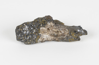 The Beechworth Burke Museum
Geological specimen - Sphalerite, Unknown
Sphalerite or sphaelerite is named from the Greek word for 'treacherous' or 'deceiver' as specimens can vary widely in appearance, making them hard to visually identify. It is a zinc sulfide with the chemical composition (Zn,Fe)S, the most important ore of zinc. Specimens of sphalerite can contain iron as a substitute for up to 25% of the usual zinc present, as well as trace elements of gallium, cadmium, geranium and indium. Small amounts of arsenic and manganese may also be detected. Sphalerite is found in igneous, sedimentary and metamorphic rocks. It forms when carbonate rock encounters acidic, zinc-bearing fluid. It often forms in veins or in fissures of the existing rock, with colours and crystal shapes dependent on the composition of the the combining elements. It forms isometric crystal shapes including cubes, tetrahedrons, octahedrons, dodecahedrons. This specimen was collected in approximately 1852, in Broken Hill, NSW, as an adjunct to the Geological Survey of Victoria. It was donated to the Museum in 1868. Victoria and other regions of Australia were surveyed for sites of potential mineral wealth throughout the 19th Century. The identification of sites containing valuable commodities such as gold, iron ore and gemstones in a locality had the potential to shape the development and history of communities and industries in the area. The discovery of gold in Victoria, for instance, had a significant influence on the development of the area now known as 'the goldfields', including Beechworth; the city of Melbourne and Victoria as a whole.The specimen is significant as an examples of surveying activity undertaken to assess and direct the development of the mineral resource industries in Victoria and Australia, as well as the movement to expand human knowledge of earth sciences such as mineralogy and geology in the nineteenth century.A pipe-shaped specimen of sulfide-mineral zinc ore displaying patches of black, brown, beige and gold colouring. The main item has associated broken pieces. geological specimen, geology, geology collection, burke museum, beechworth, mineralogy, indigo shire, geological survey, sphalerite, sphaelerite, zinc ore, broken hill, nsw, victoria, galena, fluorite, chalcopyrite, lead, cadmium, gallium, germanium, indium, iron -
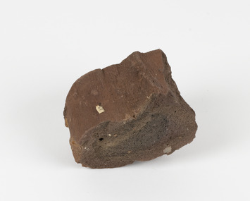 The Beechworth Burke Museum
Geological specimen - Ropy Lava
‘Ropy lava’ is known for its sculptural and layered qualities. It occurs in specific lava flows that are slow moving and slow cooling, allowing for unique formations to be created out of the motion. Ropy Lava is a flow that has a hardened crust with molten material underneath, the tension between these states is what creates its characteristic form. The brown/red hue of the stone is an indication of age, as it is oxidised iron deposits. This rock deposit is thought to be sourced from the area by Talbot, in western Victoria. This area has a rich mineral history and experienced the gold rush in the 1850's. The traditional owners of this area are the Dja Dja Wurrung people.This geological specimen shows the conditions in which the Australian landscape was created as well as provides an indication as to how these events occurred. It is representative of a common natural process that contextualises the formation of Australia with the formation of other landmasses. This specimen is part of a larger collection of geological and mineral specimens collected from around Australia (and some parts of the world) and donated to the Burke Museum between 1868-1880. A large percentage of these specimens were collected in Victoria as part of the Geological Survey of Victoria that begun in 1852 (in response to the Gold Rush) to study and map the geology of Victoria. Collecting geological specimens was an important part of mapping and understanding the scientific makeup of the earth. Many of these specimens were sent to research and collecting organisations across Australia, including the Burke Museum, to educate and encourage further study.Hand sized specimen in brown/red hues42 / victoria, talbot, lava, ropy, ropy lava, mineral, geological specimen, geological, geological heritage, natural stone, natural history -
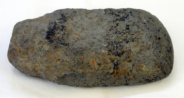
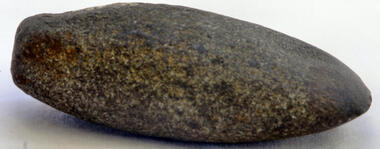 Orbost & District Historical Society
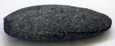
axe head
Inspected by Joanna Freslov, archaeologist 2/6/2008. Genuine Aboriginal axe head up to 2000 years old. Possibly came through trading from western district. Stone tools were used for a variety of purposes, in ways similar to those of the steel knives, axes, hammers and chisels. Ground-edge tools are made from fracture-resistant stone, such as basalt.This stone is able to withstand repeated impact, and and wqas generall used for stone axes. The stone was dug or found and then roughly shaped into a tool blank with blows from a hammerstone. The edges were then sharpened and refined by grinding the tool against a coarse, gritty rock. The necessary tools and equipment for hunting, fishing and warfare were one of the very few items that Aboriginals carried with them from place to place. Most were used for a multiplicity of purposes. Because many were made from raw natural materials, such as wood, generally only partial remains are found today. This axe head is an example of an early stone tool used by the Indigenous people of Victoria.Small grey oval-shaped axe head.axehead stone-artifact aboriginal tool -
 Orbost & District Historical Society
axe head
Inspected by Joanna Freslov, archaeologist 2.6.2008. Ground-edged axes first appeared in south-eastern Australia about 4,000 years ago and were used either with handles or hand-held. Stone tools were used for a variety of purposes, in ways similar to those of steel knives, axes, hammers and chisels. Ground-edge tools are made from fracture-resistant stone, such as basalt. This is able to withstand repeated impact making it suitable for use in objects such as stone axes. The stone was quarried, and then roughly shaped into a tool blank with blows from a hammerstone. The edges were then sharpened and refined by grinding the tool against a coarse, gritty rock. The necessary tools and equipment for hunting, fishing and warfare were one of the very few items that Aboriginals carried with them from place to place. Most were used for a multiplicity of purposes. Because many were made from raw natural materials, such as wood, generally only partial remains are found today. This item is an example of a stone tool used by the early Indigenous people of Eastern australia.A handmade stone Aboriginal axe head.axe-head aboriginal tool stone-artefact -
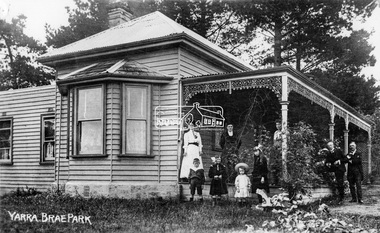 Eltham District Historical Society Inc
Negative - Photograph, Yarra Brae Park, c.1900
Weatherboard house with cast ironwork decoration on the verandah. Three women, two men and four children with rocking horse stand for a photograph. Family unknown. Yarra Brae Park was situated on Yarra Brae Road, off Sweeneys Lane, Eltham. Research in historical newspapers reveals that the Hautrive family lived there 1904-1906, followed by the Bindoon family in 1907. In the 1930s it was occupied by Hubert Rutter, his wife Beulah and four children. Hubert was an Eltham Shire Councillor. On 13 January 1939, the house burned down in the Black Friday bushfires. After the fire, the family relocated to Toorak. Reproduced on p91 of 'Pioneers & Painters'This photo forms part of a collection of photographs gathered by the Shire of Eltham for their centenary project book,"Pioneers and Painters: 100 years of the Shire of Eltham" by Alan Marshall (1971). The collection of over 500 images is held in partnership between Eltham District Historical Society and Yarra Plenty Regional Library (Eltham Library) and is now formally known as 'The Shire of Eltham Pioneers Photograph Collection.' It is significant in being the first community sourced collection representing the places and people of the Shire's first one hundred years.Digital image 4 x 5 inch B&W Neg Sepia postcard and B&W printsepp, shire of eltham pioneers photograph collection, eltham, yarra brae park, verandah, cast iron work, hautrive family, bindoon family, rutter family, pioneers and painters, houses, groups -
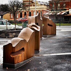 City of Ballarat
Artwork, other - Public Artwork, Cliff Burtt, Buninyong Bivium, 2016
Buninyong Bivium (2016) by Cliff Burtt engages with the geography and history of the Buninyong region in both pre and post settlement. The town of Buninyong is dominated by the profiles of Mt Helen and the extinct volcano Mt. Buninyong. Traditional land of the Wadawurrung people, today the area remains a significant site for the culture of indigenous people and their connection to the land. The profile of this sculpture is based on topographical mapping of the area, depicting sections of the landscape. The gaps between the elements of the work can be viewed as representations of the shafts sunk into the earth by the early gold miners and compound curves on the upper surfaces are mirroring the topography of the area, while cut-aways in the sides are suggestive of rock strata.The artwork is of aesthetic and social significance to the people of BallaratCorten steel sculpture made of five unique sculptural pieces secured to at concreate base at pavement levelbuninyong, cliff burtt, sculpture, public art, mining, ballarat -
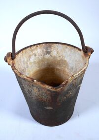 Bendigo Historical Society Inc.
Functional object - Amalgam bucket
Ore bearing rock brought out of the mine was crushed at the battery by heavy metal stampers and the fine material passed over copper pates coated with mercury. Gold particles would combine with the mercury forming an amalgam which was then scrapped off the copper plates and put into the amalgam bucket ready for retorting too extract the gold. The amalgam of mercury and gold was placed into the retort which was heated to evaporate the mercury. The mercury cooled as it ran down the pipe which was recovered to be reused leaving the gold behind. The gold would later be put into a crucible and heated to burn of impurities and the molten pure gold poured into an ingot.A heavy cast iron bucket 20 centimetres high, 16 centimetres in diameter at its base and 22 centimetres diameter at the top. It has a spout five centimetres wide protruding two centimetres. There is a handle which is a semi- circular shape 19 centimetre wide extending 14 centimetres above the bucket The inside of the bucket has an enamel coating. amalgam bucket, bendigo gold, gold retort -
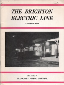 Melbourne Tram Museum
Book, Leon Marshall-Wood, "The Brighton Electric Line", 1966
Book - - the history of the Brighton Electric Line by Leon Marshall-Wood, published 1966, 3rd edition revised and enlarged. Gives a brief history of the electric tramway operated by the Victorian Railways between St. Kilda Station and the Brighton Beach railway station, that commenced operation in 1905. Also a short history of the Sandringham - Black Rock - Beaumaris - Cheltenham tram electric and horse tram lines. Includes maps, rolling stock and ticket notes. Published by Traction Publications. Has details of the AETA on the back cover and listing of some publications. See Reg Item 2062 for the 1st edition and 3400 for the second edition.Yields information about the Victorian Railways Melbourne tramways or street railways.Book - 40 pages including card coverstrams, tramways, vr, melbourne, brighton, st kilda, sandringham, black rock, horse trams -
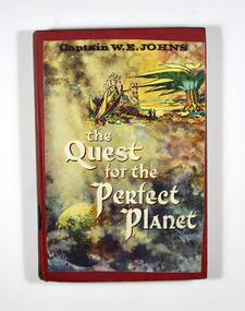 Marysville & District Historical Society
Book (item) - Hardcover book, Captain W.E. Jones, The Quest for the Perfect Planet-A story of Space Exploration, 1961
A novel by Captain W.E. Jones that was held in the Marysville State School library.A book from the Marysville State School library.Stamp of the STATE SCHOOL No. 1273/ UPPER/ 3/ FICTION/ MARYSVILLE In both front and back inside cover's labels have been removed leaving behind glue residue. Stamp of the Marysville & District Historical Society Inc/ P.O. Box 22/ Marysville 3779captain w.e. jones, planet, earth, space exploration, fiction -
 Ringwood and District Historical Society
Photographs, 1979-80 MMBW pipe line project at Hubbard Reserve, North Ringwood � Back-hoe at pit
E560 N6 Dec 1979 A43 The back-hoe works on the beginnings of pit in 39 Burlock Avenue backyard Part of a 43-photo record of the MMBW�s engineering feat in drilling a 12 inch pipe line up to 40 feet deep through rock hardened by volcanic action associated with geological fault that occurs along the line. The work took place from October 1979 to May 1980 on the southern boundary of Hubbard Reserve, North Ringwood. The collection was presented to the Ringwood Historical Research Group by J Clarke on 9th June 1980. -
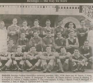 Bendigo Historical Society Inc.
Newspaper - JENNY FOLEY COLLECTION: EAGLES
Bendigo Advertiser ''The way we were'' from February 2001. Eagles: Bendigo Football Association centenary premiers, 1951, YCW. Back row: W. Garvin, C. Kelly, A. English, L. Rockes, J. Palmer, G. Bengough, P. Harrison, W. Dwyer (trainer). Centre: R. Keating, F. Krausgrill, G. Francis, L. Rodda (captain), F. Day (vice-captain), S. King, J. Mason. Front: F. Monigatti, P. Sheahan, J. Sait, A. Boyd, D. Cameron and J. Brown. The clip is in a folder.newspaper, bendigo advertiser, the way we were -
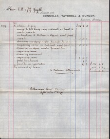 Bendigo Historical Society Inc.
Document - CONNELLY, TATCHELL, DUNLOP COLLECTION: LEGAL PAPERS, 1895 to 1899
Document. Various legal papers. 1 - 1899 - Account to Grylls Messrs N M & J G for costs. 2 - 1899 - Account to Moorhead R J Esq for costs. 3 - 1899 - Account to Lees John (Farmer Elmore) for costs. 4 - Blue envelope addressed to Newton Mr R Jr. contains 2 accounts. One titled Newton Mr R, Farmer, Bald Rock re Keogh & McKay, dated 1895. One titled Newton Mr R, Pyramid Hill re Will, dated 1898.cottage, miners, connelly, tatchell & dunlop, grylls messrs n m & j g, moorhead r j, lees john, newton mr r jr, keogh & mckay -
 Bendigo Historical Society Inc.
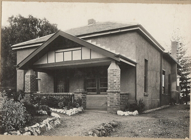
Photograph - T C WATTS & SON COLLECTION: VIOLET STREET BENDIGO, 1929
BHS CollectionBlack and white photographs (2) , mounted on rectangular grey board. House, rendered with porch with decorative gable, slate roof, 2 chimneys, established garden with rock edging. Written on back of photo board ' Geo. Every, Violet Street, 875 pounds' On back of record date stamp 27 April 1929. Note attached to record ' this house was originally kitchen and staff quarters of Alexander Bayne's house "Montanvert" ( from Myrtle Street to Violet). Address of Alexander Bayne's former house, of which this house was formerly part of, is 84 Violet Street, Bendigo.Frank A. Jeffree, Bendigoresidential, alexander bayne, violet street, bendigo, george every -
 Bendigo Historical Society Inc.
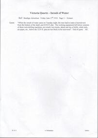
Document - DRAINAGE PROBLEMS - INRUSH OF WATER AT THE VICTORIA QUARTZ
Two handwritten extracts from the Bendigo Advertiser 17/6/1910 regarding the inrush of water at the Victoria Quartz Mine. 'When the inrush of water came on Tuesday night, the men had to make a hurried exit from the bottom of the shaft and 4254 ft. plat. The working equipment left below consists of three rock-drilling machines, air-winch, two trucks, about one ton of drills, while rails, air-pipes, etc, below the 3224 ft. plat are not likely to be recovered'. Document from Albert Richardson Collection of mining history.document, gold, drainage problems, new chum drainage association, inrush of water at the victoria quartz, bendigo advertiser 17/6/1910 page 3, ar -
 Melbourne Tram Museum
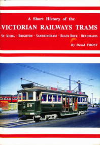
Book, David Frost, "A short history of the Victorian Railways Trams - St Kilda - Brighton - Sandringham - Black Rock - Beaumaris", May. 2006
Book - 20 pages + card covers, centre stapled titled "A short history of the Victorian Railways Trams - St Kilda - Brighton - Sandringham - Black Rock - Beaumaris". Covers have colour photographs on the outside. Page 11 has a map of the two tramways with the tram lines and features shown in red. Written by David Frost, published May 2006 by Tramway Publications. Edited by Dean Filgate. Provides details of the background of the tramways, Elwood depot fire, Sandringham depot, closure and an Epilogue Has details of the Author. Copy 2 added 31-10-2020trams, tramways, vr trams, elwood, st kilda brighton, sandringham, beaumaris -
 Orbost & District Historical Society
axe head
Inspected by Joanna Freslov, archaeologist 2.6.2008 Ground-edged axes first appeared in south-eastern Australia about 4,000 years ago and were used either with handles or hand-held. Stone tools were used for a variety of purposes, in ways similar to those of steel knives, axes, hammers and chisels. Ground-edge tools are made from fracture-resistant stone, such as basalt which is able to withstand repeated impact, and so is suitable for use in objects such as stone axes. The stone was quarried, and then roughly shaped into a tool blank with blows from a hammerstone. The edges were then sharpened and refined by grinding the tool against a coarse, gritty rockThe necessary tools and equipment for hunting, fishing and warfare were one of the very few items that Aboriginals carried with them from place to place. Most were used for a multiplicity of purposes. Because many were made from raw natural materials, such as wood, generally only partial remains are found today. This item is an example of an early axe head used by the Indigenous people of East Gippsland.A handmade stone Aboriginal axe head.aboriginal tool stone-artefact axe-head -
 The Beechworth Burke Museum
Photograph, Circa 1920 - 1950
Taken between circa 1920 - 1950 this photograph depicts a man dressed in dark trousers, a white long sleeved shirt and broad-brimmed workers hat digging around in the Three Mile Mine at Barramutha. The mine was an important gold resource and was typically mined using a method known as hydraulic sluicing whereby high powered water jets are used to dislodge rock or move sediment. The remaining water sediment slurry is directed through sluice boxes to remove the gold. The Beechworth mining district was one of six mining districts established by the governor-in-council on 4th of January 1858 under the provisions of An Act for Amending the Laws Relating to the Goldfields (21 Vic no. 32). This photograph shows historic and research value into the historical methods of hydraulic sluicing in the Beechworth mining disctrict. It also shows the evolution of the mining methods and has potential for understanding future engineering endeavors in the context of victorian mine goldfields. Black and white rectangular photograph printed on matte photographic paper.Reverse: 7597.3/ Copied from original on loan from Webb (QLD)/ Donated Nov 2009/ Barnawatha Three Mile Mine 1920-1950/ Owned by Plain Bros then Parkinsons/ Managed by John Weir, Peter Jenson, Jack Cox/ Slicing. three mile creek, three mile goldfields, three mile beechworth, goldfields, #beechworth, hydraulic mining, hydraulic sluice, burke museum -
 Eltham District Historical Society Inc
Newsletter, Newsletter, No. 234 June 2017
Contents: • A Hotel or two! by Jim Connor • 14th June Meeting - Walter Withers in Eltham • Heritage Excursion - Saturday 1st July - Eltham Lower Park - Walk and Talk • Some Important Changes - Please Note • Whatever happened to Jailhouse Rock? by Maureen Jones • Support from Eltham Rotary • Eltham District Historical Society: Alistair Knox by Jim Connor • Round the Bend Conservation Co-operative Ltd (The Co-op.) • Not Far Away • Subscriptions • Office Bearers 2017-2018 • One Hundred Years Ago: Eltham and District - January-December 2017 by Liz Pidgeon • Victorian Collections • Our Sponsors • Contacts for the Eltham District Historical Society The Shire of Eltham Historical Society was formed in October 1967. The first newsletter of the Society was issued May 1978 and has been published continuously ever since on a bi-monthly basis. With the cessation of the Shire of Eltham in late 1994, the Society's name was revised to Eltham District Historical Society and this name first appeared with issue No. 103, July 1995. The collection of the Society's newsletters provides a valuable resource on the history of the Society's activities, office bearers and committee members, guest speakers and subjects of historical interest pertinent to the former Shire of Eltham and the Eltham District.A4 photocopied newsletter distributed to membersnewsletter, eltham district historical society, shire of eltham historical society -
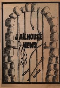 Federation University Historical Collection
Newspaper - Newspaper - Broadsheet, ZILLES COLLECTION: Ballarat School of Mines: Student Newspaper "Jailhouse News", 1981, 1981
Ballarat School of MInes was a predecessor of Federation University. Newspaper produced by students of Senior Secondary School age who attended courses at the SMB. Items include a visit to H.M. Pentridge Prison, Melbourne to see the Mess Hall Players production of "Comedians" by J Paynton, Marylin Rundle and Linda Smith; information on the camp to Lorne by Kathy Lund and Jack Begbie; film revue of "The Rock Horror Picture Show" by John Mitchell; and revue of Russell Morris and the Rubes at the Civic Hall in Ballarat. Cathy Lees wrote about the 1981 SMB Raft Race on Lake Wendouree. Resident Revoluntionary wrote about the Unions and strikes. Jeff Zilles printed the newspaper.Two A2 sheets folded -to create an 8 page student newspaper,ballarat school of mines, jailhouse news, senior secondary school students, h.m.pentridge prison, mess hall players, comedians, lorne camp, rocky horror picture show, russell morris and the rubes, civic hall ballarat, raft race, unions, j payton, marylin rundle, linda smith, john mitchell, kathy lund, jack begbie, cathy lees, debbie ward, matthew meenan, craig carr, greg walker, sherryn kieul, colleen broad, helen desert, fiona taxi, maurie gear, sue, pattie macnuttie, terry o'bow, g beanland, principal, zilles printers, graham beanland -
![Photograph - c. 1900s, [Illegible], Rock of Ages in Statuary and Song, c.1900s](/media/collectors/5423a8ba2162f1155cc09d2a/items/542cca6a2162f1124caadfb6/item-media/542cccd72162f1124caaf841/item-fit-380x285.jpg) Expression Australia
Expression AustraliaPhotograph - c. 1900s, [Illegible], Rock of Ages in Statuary and Song, c.1900s
Deaf women dressed in white flowing robes were typically used by the Society at meetings and lectures giving a performance in living statuary. This photograph is a depiction from Rock of Ages in Statuary and Song described in a review by the Spectator - the words of the hymn softly sung by the Cornish Choir to an exquisitely delicate organ accompaniment by Mr E. J. Watkins. The Grouping of Living Statuary with the limelight thrown upon them from either side, motionless as marble figures, but with the life and love and adoration in their eyes and on their faces, formed the most beautiful objects we have ever beheld. The Audience looked and listened in breathless silence and many eyes were glistening with tears.This photo is significant as a studio photograph of Deaf women who performed 'living statuar'y at many of the lectures and meetings held in the early years of the 20th century by the Adult Deaf and Dumb Society of Victoria ; possibly introduced by Ernest Abraham to add drama to the occasion.A5 black and white photograph on a cardboard frame. The photograph features five women in robes surrounding a cross."City Chambers / 114 Elizabeth Street / Melbourne" Signature of photographer or studio name illegible.