Showing 3627 items
matching landscape
-
 Bendigo Historical Society Inc.
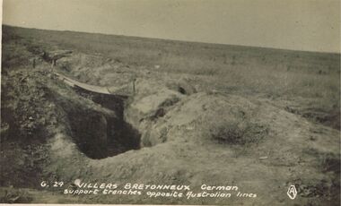
Postcard - ACC LOCK COLLECTION: VILLERS BRETONNEUX GERMAN SUPPORT TRENCHES OPPOSITE AUSTRALIAN LINES, POSTCARD, 1914-1918
Postcard, WW1, B&W image of German support trenches at Villers Bretonneux opposite the Australian Lines. Desolate landscape in background. Copy G 29postcard, postcard, ww1, france, villers bretonneux -
 Clunes Museum
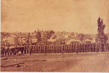
Photograph, 1868
.1 SEPIA PHOTOGRAPH AND POSTCARD OF CLUNES DETACHMENT CRESWICK VOLUNTEER RIFLE. CLUNES LANDSCAPE IN BACKGROUND. .2 POSTCARD SIZE BLACK AND WHITE IMAGE OF THE ABOVEMrs? C Wilkinson, Station Flat, Clunes The photo was taken in 1868, find your uncle and fatherlocal history, photographs, volunteer rifle detachment -
 Stawell Historical Society Inc
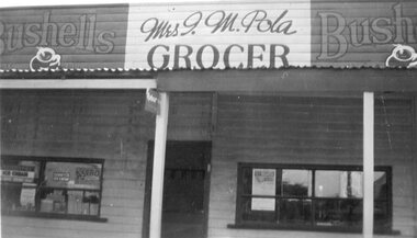
Photograph - Shop Front, Mrs I.M. Pola - Grocer
Stawell BusinessB/W Landscape - Shop front of Mrs I.M Pola advertisments in window Bushells ads eithe rside of propietors name. weatherboard with iron roof Bushells Mrs I.M. Pola Bushells Grocer On Rear written in blue: Front view of shop 117 Patrick Street Stawell, Owned by Mr T May. Then by Mr P.A. Pola, left in will to mrs I.A. Pola in 1945stawell shops businesses streetscape -
 Stawell Historical Society Inc
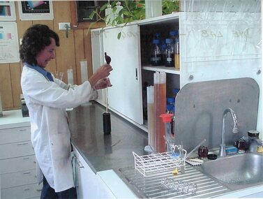
Photograph - Aunde Album 29, Dye Lab - Creating the Dye Mix, 2002
Aunde / Norwellan Textiles North Western Woolen Mills became Norwellan Textiles then AUNDEColour landscape photo: Dyer in lab coat using glassware to mix dye. Open cupboard with dyes Glassware racked above sink, glassware drainingAUnde Australia Ltd. logoindustry, aunde -
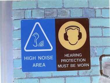 Stawell Historical Society Inc
Photograph - Aunde Album 29, Safety Signs, 2002
Aunde / Norwellan Textiles North Western Woolen Mills became Norwellan Textiles then AUNDEColour landscape photo: Blue brick wall with (2) Two signs Blue White triangle. Ear with Sound waves. Brown head with Hearing protection1 - High Noise Area 2 - Hearing Protection must be wornindustry, aunde -
 National Wool Museum
Photograph, Collins Bros Mill Pty Ltd, Physician Blanket Road Sign, Unknown
Advertising sign for the Physician Blankets Manufactured by Collins Bros Pty Ltd. Black and white photograph showcasing the Physician Blanket advertising road sign above a two story building in a landscape format. The road and moving cars are in the foreground.Front centre - Physician Chillproof Blankets. Sign Rear - Physician Brisbane (?) (?) Signwool, woollen mills, wool manufacture -
 Whitehorse Historical Society Inc.
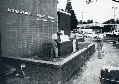
Photograph, Landscaping - Blackburn Library
Black and white photograph of workmen finishing the garden area of the Blackburn Branch of the Nunawading Public Library in 1977-78 prior to the landscaping by Parks and Gardens staff.city of nunawading - gardens and environment, blackburn branch library -
 Tramways/East Melbourne RSL Sub Branch - RSL Victoria Listing id: 27511
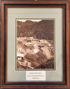
Picture, Bukit Knuckle
Framed print of a sepia photograph showing the camp at 'Bukit Knuckle', an operational base of the 3RAR in Borneo. Images shows an aerial view of the camp and surrounding landscape. Underneath the print is added 'BUKIT KNUCKLE' B COV 3RAR OPERATIONAL BASE, BORNEO 1965 On reverse is marked 'Donated by Keith Matthews 1995'bukit knuckle, sungei koemba, 3 rar, indonesia malaysia confrontation -
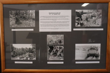 Diamond Valley Vietnam Veterans Sub-Branch
Memorabilia - Long Tan, 2/11/2020
The collage represents different elements of the Battle of Long Tan.The Battle of Long Tan is generally recognised as Australia's major battle in the Vietnam War; the the lingering memory and conclusive evidence of the courage of the soldiers in the battle holds great reverence amongst Vietnam veterans.Framed presentation of Long Tan story with 6 panels - 1 x text and 5 x photos - 4 x landscape, 1 x portraitText panel is a brief introduction of Long Tan story; 5 photos have short descriptive text.vietnam, vietnam war, battle of long tan, diamond valley vietnam veterans sub branch -
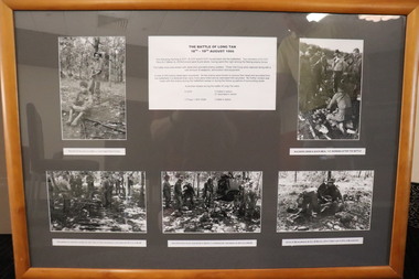 Diamond Valley Vietnam Veterans Sub-Branch
Memorabilia - Long Tan, c2020
Item has pictures of Long Tan and includes text describing in brief The Battle of Long Tan.The Battle of Long Tan is generally recognised as Australia's major battle in the Vietnam War; the the lingering memory and conclusive evidence of the courage of the soldiers in the battle holds great reverence amongst Vietnam veterans.Framed Presentation of the Long Tan story with 6 panels - 1 x text and 5 x photos - 2 x portrait, 3 x landscapeText panel continues a brief introduction to the Long Tan story; 5 photos have short descriptive textvietnam, vietnam war, battle of long tan, diamond valley vietnam veterans sub branch -
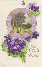 Bendigo Historical Society Inc.
Postcard - Alice McGregor Postcard Collection, 1900 - 1920
Alice McGREGOR Born: 1908; unknown parents. Possibly adopted by the Salter family? Electoral Roll 1936: Highland Terrace Kangaroo Flat. Alice Mary Salter and William Robert Salter living together; presumed to be sister and brother. William Robert Salter was killed in a MVA in Bendigo in 1937 aged 26. In Victoria in 1938, Alice Mary Salter married James Thomas McGregor (born Victoria 1917, died Victoria 1983, buried Fawkner Cemetery) Lived: 1968; 22 Wade Street Golden Square Alice McGregor Died: 1999 aged 91 at Anne Caudle Centre, Bendigo Buried: Kangaroo Flat Cemetery See additional research. Postcard Album of Alice McGregor contained 86 post cards.Postcard Album of Alice McGregor contained 86 post cards. See 1400. Purple violets surrounding a painted landscape scene surrounded by letters XMAS. Addressed to Miss Shatford from Jessie Simpson. Dated 22/12/08.postcard, collector, alice mcgregor -
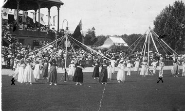 Stawell Historical Society Inc
Photograph, Dancing the May Pole in Central Park
Huttley - Martin FamilyB/W Landscape: At Central PARK. Students dancing the May Poe watched by crowd. 1 Pole for Girls 1 Pole for Boys, in sailor suitsPostcard Correspondence Address only Kodak Madge and ray Huttley Stawell huttley, martin -
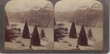 Linton and District Historical Society Inc
Stereograph, Underwood & Underwood, Publishers, Across Lake Lucerne's Deep Waters, Copyright 1902
One of two sets of stereographs donated by the O'Beirne family along with a stereoscope for viewing (Stereoscope is Registration no. 2014-51).Stereograph of two black and white images. Images are of a landscape. Trees, stairs, people in foreground. River through centre of image with snowcapped hill tops in background.1868 - Across Lake Lucerne's deep waters. from the cliffs of the Axenstein to / Uri Rothstock, Switzerland.stereographs -
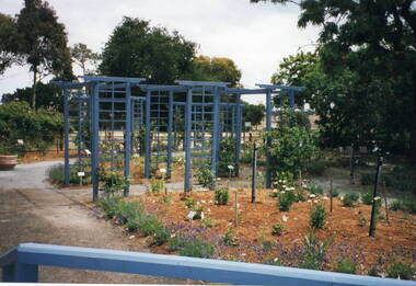 Sunbury Family History and Heritage Society Inc.
Photograph, Veronica Burgess, Alister Clark Rose Garden, 12th December 1999
The garden in the photograph is a section of the newly designed and planted Alister Clark Memorial Rose Garden situated in the grounds of the former Bulla Roads Board property. The garden was officially opened on 12th December 1999 in the grounds of the former Shire of Bulla Office building.The garden honours the work of Alister Clarke, who developed many different of rose varieties suited to Australia's climate at his 'Glenara' property in Bulla.A non-digital coloured photograph of a newly landscaped garden with a series of trellises in the garden bed and young rose bushes. Some mature trees are growing in the background.rose gardens, roses, alister clark memorial rose garden, glenara homestead, bulla -
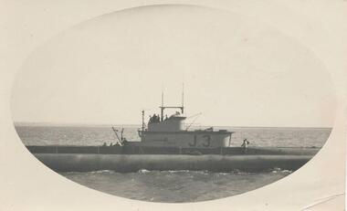 Phillip Island and District Historical Society Inc.
Photograph, Submarine in Westernport, c. 1940
Part of a collection from Jessie Smith of Phillip Island events and landscapes.Submarine J.3 at sea - close up in Westernport.local history, photographs, military history, navy, naval submarine, cowes jetty, phillip island, black & white photograph, wwii, jessie smith collection, stan mcfee -
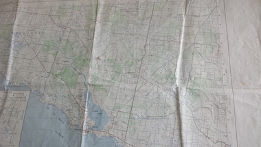 Peterborough History Group
Map - Government map, Government Printer, Port campbell, 1957
Aerial survey map showing roads, vegetation and other landscape features.Significant because it shows the detail of the region in 1957Original 1957 State Aerial Survey Map of Port Campbell region, including Peterboroughpeterborough, aerial survey map, maps, port campell -
 Stawell Historical Society Inc
Map - Plan, Earle and Partners, Restoration of Pleasant Creek Courthouse Stawell West 1974, 24/10/1974
Drawing 1 Is not in Collection Drawing 5 Landscape Pal is 5092-13 A2 Sheets. Drawing 3 is Elevations. Drawing 2 is Gallery And Roof Plan. Drawing 4 Details24 Oct 74. And 25 Oct 74stawell historical -
University of Melbourne, Burnley Campus Archives
Work on paper (item) - Student Work, Alexandra White, Construction Elements, Uncertain, probably 2017-2018
Submitted as an assignment for HORT90035, 'Landscape Construction and Graphics,' coordinated by Andrew Laidlaw. assignment, landscaping, burnley horticultural college, landscape construction and graphics, hort90035 -
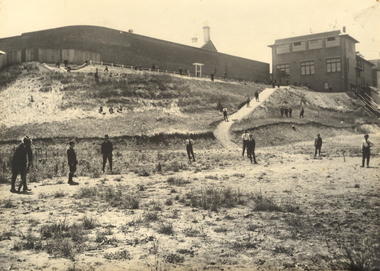 Federation University Historical Collection
Photograph, Ballarat Junior Technical School - outside the Ballarat Gaol Wall, c1921
In February 1913 the Ballarat Junior Technical School opened its doors to its 86 pupils. The old bluestone building in the grounds of the Dana Street Primary School became their temporary home for eight years. In its early years the school offered only a two-year course. The first year was of a general nature giving a thorough grounding in Mathematics and Instrumental Drawing, and introducing students to the various branches of trade work. The second-year students studied for the Junior Technical Certificate and specialized in a course of their choice - either a trade (Woodwork or Fitting and Turning) or a course leading to higher studies at the School of Mines. Increased enrolment - 86 to 110 in the second year. Some applicants were turned away due to lack of space. An abandoned single room school was brought in and this helped for a time. Plans were developed and a two-storied red brick building in the vacinity of the School of Mines was build. An acre of land was reclaimed from the north-east corner of the Ballarat Gaol. The school backed onto the wall of the gaol. The task of landscaping and terracing of the area was to cost a great deal and time. The boys did much of the heavy work. This kept them occupied as the official playground areas were still full of rubble.View from the south-east of the Junior Technical School with the slope from the gaol wall down to the area known as the Battery Paddock. The new school building was a two-storied red brick building along the Education Department style of the 1920s. On 9 September 1921, the Junior Technical School building was officially opened. Much work was needed to terrace and landscape the area. Students shown in various areas of the grounds.junior technical school, dana street primary school, bluestone, mathematics, instrumental drawing, junior technical certificate, woodwork, fitting and turning, school of mines, ballarat gaol, landscaping, terracing, gaol wall, cricket -
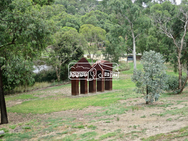 Eltham District Historical Society Inc
Photograph, Jim Connor, Main Road, Eltham, 14 Jan 2017
Eltham Gateway, Classical Landscape, Cliff Burtt 1996, Alistair Knox ParkTomorrow's history documented todayeltham, jim connor collection, main road, eltham gateway, alistair knox park, art in public places, classical-landscape (1996), cliff burtt -
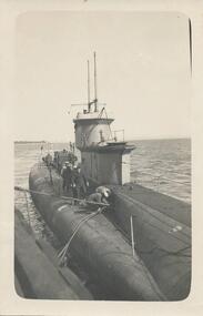 Phillip Island and District Historical Society Inc.
Photograph, Submarine in Westernport
From Jessie Smith's collection of Island Events & Landscapes. Submarine tied to JettySubmarine tied to jetty. Black & White close up with sailors at middle left in a group. Two masts on towerlocal history, photographs, navy, cowes jetty, naval vessel, black & white photograph, world war ii, submarine cowes pier, jessie smith collection, stan mcfee -
Tatura Irrigation & Wartime Camps Museum
Photograph - copy, 1989 copy
Copy of original black and white photograph of rock used for landscaping at POW camps.Copy of black and white photograph. Working party at the quarry loading rock onto truck. NCO supervising in background.camp 13, murchison victoria, internment camps, internment camp gardens -
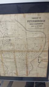 Peterborough History Group
Map - Map of the township of Peterborough, Township of Peterborough
Undated but indicative of the layout of the town. includes printed notes regarding the landscape and flora.Old map of the township of Peterborough from J S Irvine.A3 size paper map with tape around the sides. Includes handwritten notes.Handwritten on the rear is J.S Irvinepeterborough, old maps -
Ringwood and District Historical Society
Souvenir programmes, City of Ringwood Souvenir Programme, Nostalgia Night, 25 November 1988, 1988
Devised by the Ringwood Bicentennial Community Committee. Used to celebrate the bicentenary 1788 - 1988 and also book launch by Miss La Scala, State Librarian of 'Place of Many Eagles' by Hugh Anderson in the Convention centre, Ringwood on 25 November, 1988.Trifold landscape cardboard programmes with brown printing, pink coloured, 2 copies. +Additional Keywords: La Scala, Jane (State Librarian) / Anderson, Hugh (Author)Souvenir Programmes, Nostalgia Night, 25 November 1988 -
 Ringwood and District Historical Society
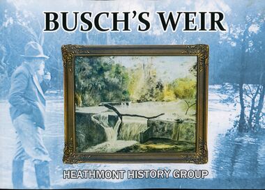
Book, PenFolk Publishing, Busch's Weir, 2019
One of several Dandenong Creek marker posts inscriptions: "Busch's Weir was located at this section of the creek between 1930s to 1960s. In the 1930s, German migrant Hermann Otto Busch and his wife Dorothea moved to Bayswater and opened the Waldheim Farm Guest House. Busch built a concrete weir to create a popular swimming and fishing destination. The weir was a thriving attraction until the 1960s. Although little remains, it is fondly remembered by the Heathmont community. City dwellers would retreat to the guesthouse and wander down to Dandenong Creek to enjoy a weekend in the 'country'. Busch's guest house, tea rooms, and weir attracted locals and tourists alike."A private weir on Dandenong Creek Bayswater and Heathmont, 1930s-1967. Landscape layout soft covered book by Heathmont History Group (Ringwood & District Historical Society.Front cover image: A 1956 painting by Hermann Busch of his weir. The publication of this book has been made possible by a financial grant from Melbourne Water, as part of the Enhancing Our Dandenong Creek program. We particularly acknowledge the encouragement and support of Sarah Watkins, Senior Planning Engineer, MW. -
 Bendigo Military Museum
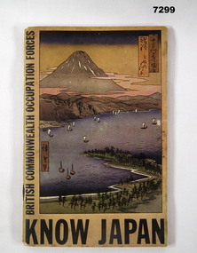
Book - BOOK, BCOF, The Rodney Press, "KNOW JAPAN", C.1946
Purpose of the book was to provide members with some background to an understanding of the Japanese People to help the fit into the democratic world. Item in the collection of Richard William McGILVERY, RAAF. refer Cat No. 7287P for his service details, photos and awards.Cover - yellow/ orange colour - book of 96 pages. Title on front with picture of landscape of a bay with some ships and mountain in background in various pale pastel colours.Title of book "KNOW JAPAN"/ On side " BRITISH COMMONWEALTH OCCUPATIONAL FORCES" Inside back cover is some pencil notations and numbers. bcof, book, history, richard william mcgilvery -
 Phillip Island and District Historical Society Inc.
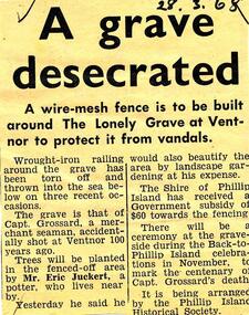
Newspaper clippings, 28/03/1968
Collection of newspaper clippers in scrap book dated 1960 - 1973Newspaper article concerning the grave of Captain Grossard at Ventnor; desecration; fence to be built; landscape works; proposed ceremony November 1968 to coincide with "Back to Phillip Island"."A grave desecrated"local history, newspapers, protection for "lonely grave" at ventnor, phillip island, captain grossard, captain grossard's grave, jean jamieson -
 Glen Eira Historical Society
Album - Album page, Hotham Street, Circa 1972
This photograph is part of the Caulfield Historical Album 1972. This album was created in approximately 1972 as part of a project by the Caulfield Historical Society to assist in identifying buildings worthy of preservation. The album is related to a Survey the Caulfield Historical Society developed in collaboration with the National Trust of Australia (Victoria) and Caulfield City Council to identify historic buildings within the City of Caulfield that warranted the protection of a National Trust Classification. Principal photographer thought to be Trevor Hart, member of Caulfield Historical Society. Most photographs were taken between 1966-1972 with a small number of photographs being older and from unknown sources. All photographs are black and white except where stated, with 386 photographs over 198 pages.Victorian Heritage Database - Hotham Street Road Overbridge HO116 Heritage Overlay - City of Glen Eira https://vhd.heritagecouncil.vic.gov.au/places/43557 (as of 04/07/2021) The Hotham Street road overbridge is located on the Sandringham railway line between Ripponlea and Elsternwick railway stations. It is presumed to have been built by contractors Sharp and Campbell who signed a contract on 25th . November, 1881 to construct a second line of railway between Windsor and Elsternwick. This contract was completed during 1882 and the bridge may have been designed in the year when Robert Watson took over from William Elsdon as engineer in chief for the Victorian railways. It is historically, aesthetically and technically significant. It is historically significant (Criterion A) to the extent that it demonstrates the standards of construction adopted by the Victorian Railways Department when it rebuilt the lines acquired from the private railway companies, (compare the Geelong and Melbourne Railway Co's line from Newport to Geelong, acquired in 1860). It is aesthetically significant (Criterion E) as an intact nineteenth century structure of its type, many similar girder bridges having been renewed with concrete girders in recent years. The bluestone abutments demonstrate high standards of stone masonry and are representative of Departmental work of the period. This bridge forms one of a group of historic structures on the railway to Brighton Beach and therefore contributes to the line's cultural importance as a whole. The survival of the riveted iron girders with their bellied angle iron struts is important since these elements are representative of the civil engineering practices of the Victorian Railways at the time and constitute the technical significance (Criterion F) of the structure.Page 96 of Photograph Album with three photographs (one portrait and two landscape) from Hotham Street - two external views of one house and a railway bridge.Handwritten: Hotham Street [top right] / 112 HOTHAM ST [under top left photo] / BRIDGE OVER SANDRINGHAM RAILWAY [under top right photo] / 112 HOTHAM ST CNR MELBY AVE [under bottom left photo] / 96 [bottom right]trevor hart, elsternwick, hotham street, caulfield, houses, brick, bay windows, verandahs, railway bridges, tunnels, gardens, bluestone, civil engineering, victorian railways, sharp and campbell, contractors -
 Glen Eira Historical Society
Album - Album page, Myoora, 405 Alma Road, Circa 1972
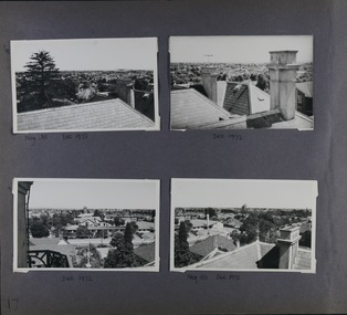
This photograph is part of the Caulfield Historical Album 1972. This album was created in approximately 1972 as part of a project by the Caulfield Historical Society to assist in identifying buildings worthy of preservation. The album is related to a Survey the Caulfield Historical Society developed in collaboration with the National Trust of Australia (Victoria) and Caulfield City Council to identify historic buildings within the City of Caulfield that warranted the protection of a National Trust Classification. Principal photographer thought to be Trevor Hart, member of Caulfield Historical Society. Most photographs were taken between 1966-1972 with a small number of photographs being older and from unknown sources. All photographs are black and white except where stated, with 386 photographs over 198 pages.Victorian Heritage Register (VHR) Number H0490 From the Victorian Heritage Register Database - Citation for Myoora https://vhd.heritagecouncil.vic.gov.au/places/275 (as at 6/10/2020) Myoora, 405 Alma Road, North Caulfield, was designed by Reed, Henderson & Smart and can be attributed to Anketell Henderson. It was built in 1886 and 1887 for Thomas Christian, who had founded the fabled gold mine, the Day Dawn at Charters Towers. He never occupied the house although his widow lived there for some time. The house was subdivided into three and later six flats. Myoora was one of many large mansions on broad acres with gardens in Caulfield. Perhaps the grandest was Labassa. The mansions date from the 1850s through to the late 1890s. The siting of Myoora on a ridge influenced its planning and composition. A central hall and corridor along the ridge is entered from the centre of the more formal north facade. The entrance is marked by an elaborately detailed tower. A stair turret provides a second accent. The western end of the building is completed by a massively detailed chimney as the service wing. The south facade enjoyed an outlook to port phillip from a two-storey cast iron verandah. Bay windows, chimneys, the tower and the turret and minor details are brought together in a sophisticated asymmetrical composition. This is reflected in the planning. The asymmetry of Myoora pivoting on the tower is the most notable feature of the building. The walls are built of cement rendered brick. The cement render has not been painted. The roof is slate. The balconies and verandah are cast iron. The footings and cellar are bluestone. The architectural firm Reed, Henderson & Smart was very prominent in Victoria in the nineteenth century. Anketell Henderson was an eminent and well respected member of the profession. He worked successfully in London and interstate as well as in Victoria. They were better known for commercial and public buildings. Myoora is an important private commission. The style of Myoora is a combination of details from the Continental and English Renaissance through the boom style and the Queen Anne style. There is also an early influence from the American Romanesque style especially in the stair turret. The latter style was important at the turn of the century and Myoora is a significant precursor. Other buildings of a similar scale survive in Caulfield and elsewhere. Labassa, the most fabulous, is quite different stylistically as are most of the other comparable mansions. Stonnington is perhaps closer but relies on different details from the Queen Anne style and lacks any American influence. For its historical associations through its owners and architects, for its style and composition and for its intactness, Myoora is significant at a State level. The craftmanship of Myoora is what could be expected of a building of the time and type. It is relatively intact and in fair condition. The main staircase has been removed, minor alterations to decorative features have occurred and additions have been made to the exterior.Page 17 of Photograph Album including four black and white photographs. All are arranged in landscape orientation with two on the top half of the page and the other two below.Handwritten: Neg 185 Dec 1972 [under top left photo] / Dec 1972 [under top right photo] / Dec 1972 [under bottom left photo] / Neg 153 Dec 1972 [under bottom right photo] / 17 [bottom left]caulfield north, trevor hart, alma road, mansion, myoora, tower, thomas christian, 1880's, queen anne, cement rendered brick, unpainted, balconies, verandahs, anketell henderson, continental and english renaissance, american romanesque, cast iron balconies, panoramic views, streetscapes, cast iron work, reed henderson & smart, gardens, asymmetrical style, slate roofs -
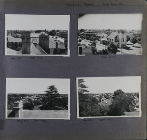 Glen Eira Historical Society
Album - Album page, Myoora, 405 Alma Road, Circa 1972
This photograph is part of the Caulfield Historical Album 1972. This album was created in approximately 1972 as part of a project by the Caulfield Historical Society to assist in identifying buildings worthy of preservation. The album is related to a Survey the Caulfield Historical Society developed in collaboration with the National Trust of Australia (Victoria) and Caulfield City Council to identify historic buildings within the City of Caulfield that warranted the protection of a National Trust Classification. Principal photographer thought to be Trevor Hart, member of Caulfield Historical Society. Most photographs were taken between 1966-1972 with a small number of photographs being older and from unknown sources. All photographs are black and white except where stated, with 386 photographs over 198 pages.Victorian Heritage Register (VHR) Number H0490 From the Victorian Heritage Register Database - Citation for Myoora https://vhd.heritagecouncil.vic.gov.au/places/275 (as at 6/10/2020) Myoora, 405 Alma Road, North Caulfield, was designed by Reed, Henderson & Smart and can be attributed to Anketell Henderson. It was built in 1886 and 1887 for Thomas Christian, who had founded the fabled gold mine, the Day Dawn at Charters Towers. He never occupied the house although his widow lived there for some time. The house was subdivided into three and later six flats. Myoora was one of many large mansions on broad acres with gardens in Caulfield. Perhaps the grandest was Labassa. The mansions date from the 1850s through to the late 1890s. The siting of Myoora on a ridge influenced its planning and composition. A central hall and corridor along the ridge is entered from the centre of the more formal north facade. The entrance is marked by an elaborately detailed tower. A stair turret provides a second accent. The western end of the building is completed by a massively detailed chimney as the service wing. The south facade enjoyed an outlook to port phillip from a two-storey cast iron verandah. Bay windows, chimneys, the tower and the turret and minor details are brought together in a sophisticated asymmetrical composition. This is reflected in the planning. The asymmetry of Myoora pivoting on the tower is the most notable feature of the building. The walls are built of cement rendered brick. The cement render has not been painted. The roof is slate. The balconies and verandah are cast iron. The footings and cellar are bluestone. The architectural firm Reed, Henderson & Smart was very prominent in Victoria in the nineteenth century. Anketell Henderson was an eminent and well respected member of the profession. He worked successfully in London and interstate as well as in Victoria. They were better known for commercial and public buildings. Myoora is an important private commission. The style of Myoora is a combination of details from the Continental and English Renaissance through the boom style and the Queen Anne style. There is also an early influence from the American Romanesque style especially in the stair turret. The latter style was important at the turn of the century and Myoora is a significant precursor. Other buildings of a similar scale survive in Caulfield and elsewhere. Labassa, the most fabulous, is quite different stylistically as are most of the other comparable mansions. Stonnington is perhaps closer but relies on different details from the Queen Anne style and lacks any American influence. For its historical associations through its owners and architects, for its style and composition and for its intactness, Myoora is significant at a State level. The craftmanship of Myoora is what could be expected of a building of the time and type. It is relatively intact and in fair condition. The main staircase has been removed, minor alterations to decorative features have occurred and additions have been made to the exterior.Page 18 of Photograph Album including four black and white photographs. All are arranged in landscape orientation with two on the top half of the page and the other two below.Handwritten: views from "Myoora" 405 Alma Road / [top right hand] / Neg 188 Dec 1972 [under top left photo] / Dec 1972 [under top right photo] / Neg 184 Dec 1972 [under bottom left photo] / Neg 168 Dec 1972 [under bottom right photo] / 18 [bottom right]caulfield north, trevor hart, alma road, mansion, myoora, tower, thomas christian, 1880's, queen anne, turret, cement rendered brick, unpainted, balconies, verandahs, anketell henderson, continental and english renaissance, american romanesque, cast iron balconies, panoramic views, streetscapes, cast iron work, reed henderson & smart, asymmetrical style, gardens, slate roofs