Showing 1540 items
matching site plan
-
 Melbourne Tram Museum
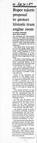
Newspaper - Photocopy, The Age Newspaper, Roper rejects proposal to protect historic tram engine room, 28-11-1989
Provides a report from The Age, 28-11-1989 written by Ingrid Swendsen, about the rejection by the Planning and Environment Minister , Tom Roper to protect the former cable tram winding or Engine house on the corner of Bridge and Punt Roads Richmond, despite the recommendation of the Historic Buildings Council to add it to the register. The building was later demolished by the Roads Corporation to widen the intersection. The Tramways have a small sub-station on the site. Quotes Douglas Hill of the National Trust and Roz Hansen of the Historic Buildings Council. Provides a report on the rejection of a recommendation to protect a historic building.Photocopy of a newspaper clipping from The Age 28-11-1989 - Roper rejects proposal to protect historic tram engine roomtrams, tramways, cable trams, engine house, winding house, punt road, bridge road, demolition, richmond, historic buildings council -
 University of Melbourne, Burnley Campus Archives
Newspaper - Newspaper Cutting, The Argus, Acclimatisation Society, 1861
Copy of article in "The Argus" 08.08.1861 the meeting of the Acclimatisation Society with a description of the competition for a design of the gardens, won by Alfred Lynch. Also copies of plans held in B18.0029 and B18.0030. Chronological history (from the National Trust of Australia, Victoria website) giving information about the 1861 design for the site by Alfred Lynch.the argus, acclimatisation society, alfred lynch, competition for design of gardens, plans -
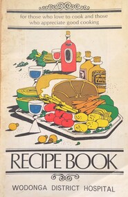 Wodonga & District Historical Society Inc
Booklet - Recipe Book Wodonga District Hospital
The Wodonga Base Hospital was officially opened on 16th January 1954. The first public meeting to discuss plans for a hospital in the district was held on 28th June 1934, but the proposed Bush Nursing Hospital did not eventuate. In 1946 another push began and land on the current site in Vernon Street was set aside. After a lengthy period of fundraising by the local community the hospital was finally realised. By 1975 the Hospital has become increasingly busy with the accommodation having increased to 68 beds, equipment being updated and a range of ancillary services extended. Between 1974, the hospital had admitted 41,944 patients and babies born in the hospital totalled 3,996. Extension to the Hospital were urgently needed to meet the demand on the facilities. The Victorian Government had approved the extensions and provided funds of $772,000. The Committee of Management needed to meet the cost of furnishings and equipment. Once again the Wodonga community were called upon to support their Hospital. This recipe booklet was printed as part of this fundraising campaign..The Wodonga Base Hospital was officially opened on 16th January 1954. The first public meeting to discuss plans for a hospital in the district was held on 28th June 1934, but the proposed Bush Nursing Hospital did not eventuate. In 1946 another push began and land on the current site in Vernon Street was set aside. After a lengthy period of fundraising by the local community the hospital was finally realised. By 1975 the Hospital had become increasingly busy with the accommodation having increased to 68 beds, equipment being updated and a range of ancillary services extended. Between 1954 and 1974, the hospital had admitted 41,944 patients and babies born in the hospital totalled 3,996. Extensions to the Hospital were urgently needed to meet the demand on the facilities. The Victorian Government had approved the extensions and provided funds of $772,000. The Committee of Management needed to meet the cost of furnishings and equipment. Once again the Wodonga community were called upon to support their Hospital. This recipe booklet was printed as part of the fundraising campaign.This item is significant because it represents efforts made by the Wodonga community to establish and maintain appropriate Hospital facilities in Wodonga.A small publication of recipes and advertising produced to raise funds for the development of Wodonga District Hospital.wodonga base hospital, wodonga community -
 Buninyong Visitor Information Centre
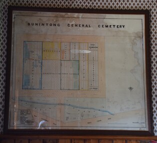
Plan - Cemetery Plan, Buninyong General Cemetery
Plan of the complete layout of the Buninyong General Cemetery drawn by Robert [surname unclear] on 6 April 1871.Framed and glazed original large hand drawn plan of the Buninyong General Cemetery, showing the locations of denominational sections and plots. Buninyong General Cemeterycemeteries, historic sites, buninyong -
 City of Kingston
Pamphlet - Colour, Arthur Tuckett & Son, Auctioneers and Subdivisional Specialists, Auction of Station Estate, Moorabbin, 1923
... in the area, and a sales plan for home sites and shop fronts... and churches in the area, and a sales plan for home sites and shop ...Sales plan for land in the suburb of Moorabbin, bounded by Railway Crescent, South Road, Jasper Road and Pattersons Road.The developing urban area of Moorabbin within the City of Kingston. This land sale pamphlet illustrates the subdivision of land within the municipality and the changing demographic of the district as new houses are constructed.Colour pamphlet advertising an auction of the Station Estate Moorabbin. Incorporates details of the shopping facilities, proximity to the railway line, variety of schools and churches in the area, and a sales plan for home sites and shop fronts. Incorporates a map of the estate bordered by Pattersons Road, Japer Road, South Road and Railway Crescent. Handwritten in grey pencil top right front page: Station Estate / late [indecipherable] Handwritten in red pencil on subdivision map: x [on majority of properties marked on the map] Handwritten in grey pencil on subdivision map: additional subdivisions drawn in and large lines drawn across the mapmoorabbin, land sales, estate -
 Bendigo Historical Society Inc.
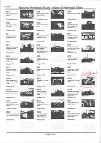
Book - MARONG HERITAGE STUDY
Eighty one loose pages stapled together. Marong Heritage Study: Index of Heritage Sites. First three pages identifies the various sites followed by an in depth description of each sites and the recommendations for inclusion in the Heritage Overlay Table in the City of Greater Bendigo Planning Scheme.bendigo, council, heritage study -
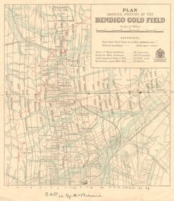 Bendigo Historical Society Inc.
Map - DEPARTMENT OF MINES VICTORIA : PLAN SHOWING PORTION OF THE BENDIGO GOLD FIELD
Department of Mines Victoria. Plan showing portion of the Bendigo Gold Field. On the back is written, in ink, J. J. Tyler 1937 Northern Area. (He was a teacher at Bendigo High - see donation notes). Across the bottom of the map is written ' M. Hill cr. Myrtle & Barnard' .The named reef lines have been numbered with ink across the bottom of the map. The gullies have been coloured with green pencil and a red pencil line is drawn through the western side of the map. Additional information: anticlinal axial lines at surface, alluvial workings, shaft sites, area of Main Goldfield, Deepest mine workings, Gold output of field to 1935, and Dividends paid 1870 - 1935.bendigo, gold mining, bendigo gold field. gold mining. tyler, j. j. -
Port Melbourne Historical & Preservation Society
Audio - PMHPS Meeting, Fairstar, Robert PRADOLIN and Rob JELL, Glen Stuart, 1996
... . Discussing plans for HMAS Lonsdale site development. Recording... to Faristar. Discussing plans for HMAS Lonsdale site development ...Recording of PMHPS meeting on 22.01.1996. Recorded by Glen STUART at the Liardet Community Centre. Speakers were Robert PRADOLIN of Faristar and Rob JELL, consultant to Faristar. Discussing plans for HMAS Lonsdale site development. Recording duration 01:11:17built environment - commercial, faristar, sandridge lagoon, robert pradolin, rob jell -
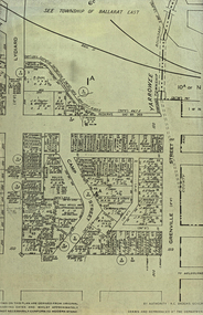 Federation University Historical Collection
Plan, Camp Street Ballarat Parish Plan
Camp Street was the site of the original goldfields camp reserve, and it is from here that soldiers and police troopers left to attack the Eureka Stockade on 03 December 1854.PLan of Camp Street Ballaratcamp street, police reserve, old colonists' association, grenville street, lydiard street north, t. cowan, r. surtees, c.m. watson, w.h. foster, j.b. humffray, j.j. goller, h.r. caselli, henry caselli, market reserve, e.v. gribble, old colonists' association of ballarat -
![Plan, Improvements on the Camp Reserve Ballarat, 1870, 26/4/1870 (exact); Traced by Henry [Mornes?], district surveyor, on the above date](/media/collectors/4f729f6797f83e0308601707/items/4f72a4fa97f83e0308602508/item-media/59b79d3921ea680200c6b8a7/item-fit-380x285.jpg) Federation University Historical Collection
Federation University Historical CollectionPlan, Improvements on the Camp Reserve Ballarat, 1870, 26/4/1870 (exact); Traced by Henry [Mornes?], district surveyor, on the above date
The Ballarat Camp housed the Goldfields administrators. It was from this site that the troopers left on the morning of 3 December 1854 to attack the Eureka Stockade. Much of the area shown in on the west side of Camp Street is now used by the Federation University Arts Academy.Hand-drawn plan on white linen showing the camp reserve in what is now known Ballarat's Camp Street. The plan shows allotments in an area bounded by Mair, Sturt and Lydiard Streets. The plan has colours indicating wooden buildings, stone buildings, brick buildings, Wood & zinc buildings, and wood & brick buildings.ballarat, camp street, horace walker, henry mornes, goldfields architecture, reserve for public, buildings, goldfields administration, eureka stockade