Showing 3220 items
matching road map
-
 Whitehorse Historical Society Inc.
Map, Parkmore Estate, c1958 - 1959
Plan of 'Parkmore' subdivision by Southern Construction Company, 444 lots, c 1958-59.land subdivision, forest hill, parkmore road, forest hill, ranfurlie road, forest hill, ranfurlie court, forest hill, everglade avenue, forest hill, hampshire road, forest hill, quentin street, forest hill, cedar court, forest hill, martin court, forest hill, wandin court, forest hill, inglewood avenue, forest hill, deauville street, forest hill, oberon street, forest hill, vanbrook street, forest hill, husband road, forest hill, springvale road, forest hill, southern construction company -
Whitehorse Historical Society Inc.
Map, Anjaya Court, Blackburn, ca1970
[Plan of] Anjaya Court, Blackburn, Lots 6 - 20and of Leons Court, Lots 21-24. One copy with proposed sewerage plan.anjaya court, blackburn, land subdivision, sewerage and sanitation -
Whitehorse Historical Society Inc.
Map, M.M.B.W - Schwerkolt Cottage, 30/04/1968
Extract from M.M.B.W. map No 79 showing proposed main road, open space, residential zones C & D and location of Schwerkolt Cottage. Approved 40/04/1968. 2 copiesschwerkolt cottage, melbourne and metropolitan board of works, eastern freeway -
Whitehorse Historical Society Inc.
Document - Correspondence, Letter and Map Schwerkolt houses, 9/11/1993
Letter to W. Gray, Nunawading Historical Society from Glyn France enclosing map of Schwerkolt property and rough plan of old stone house drawn by Arthur Schwerkolt [map filed at A-SP 120]. Gives information about dates of building 'old' and 'new' houses.schwerkolt, arthur, schwerkolt, myra, france glyn, schwerkolt cottage -
Whitehorse Historical Society Inc.
Map, Schwerkolt property by Arthur Schwerkolt, 1993
Map of Schwerkolt property and rough plan of original stone house produced by Arthur Schwerkolt. Also copy of covering letterschwerkolt cottage -
 Whitehorse Historical Society Inc.
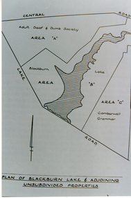
Photograph, Plan of Blackburn Lake
Black and white photograph of a map of Blackburn Lake showing Adult Deaf & Dumb Society's land and the Camberwell Grammar land on either. Camberwell Grammar was later bought by the former City Of Nunawading.adult deaf & dumb society's flower farm, blackburn lake, camberwell grammar school. -
 Whitehorse Historical Society Inc.
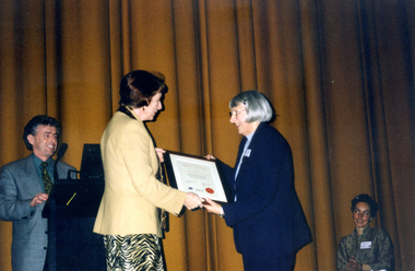
Photograph, Museum Accreditation Ceremony, 1/05/2000 12:00:00 AM
Coloured photo of president of Nunawading and District Historical Society, Valda Arrowsmith, receiving Accreditation Certificate from Minister for the Arts, Mary Delahunty on behalf of Museum Accredit ion Program (MAP) of Museums Australia Victoria at the Capitol Theatre melbourne.museums australia (vic) museum accreditation program, nunawading and district historical society, schwerkolt cottage and museum complex, arrowsmith, valda, delahunty, mary, victoria. ministry of the arts -
 Whitehorse Historical Society Inc.
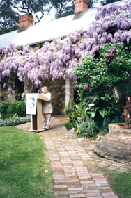
Photograph, Launch of Valley of the Arts Tourist Map, 1/10/2000 12:00:00 AM
Coloured photo of Minister for Tourism, John Pandazopoulos and Mayor of City of Whitehorse, Cr, Jessie MacCallum at launch of Co-operative venture Valley of the Arts Tourist Map at Schwerkolt Cottage on 6th October 2000.pandazopoulos, john, maccallum. jessie, city of whitehorse, valley of the arts, schwerkolt cottage. -
 Whitehorse Historical Society Inc.
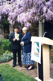
Photograph, Launch of Valley of the Arts Tourist Map, 1/10/2000 12:00:00 AM
Coloured photo of Chief Executive Officer of City of Whitehorse, Noelene Duff, speaking at the launch of the Valley of the Arts Tourist Map at Schwerkolt Cottage on 6 October 2000.city of whitehorse, duff, noelene, valley of the arts, schwerkolt cottage -
 Whitehorse Historical Society Inc.
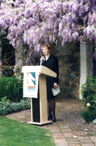
Photograph, Launch of Valley of the Arts Tourist Map, 1/10/2000 12:00:00 AM
Coloured Photo of President of the Valley of the Arts Committee speaking at the launch of the Valley of the Arts Tourists Map at Schwerkolt Cottage.valley of the arts, schwerkolt -
 Whitehorse Historical Society Inc.
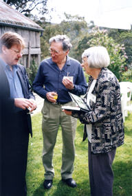
Photograph, Launch of Valley of the Arts Tourist Map, 1/10/2000 12:00:00 AM
Coloured photo of Bruce Atkinson, M.L.C., Ted and Valda Arrowsmith (President of Society) at the launch of the Valley of the Arts Tourists Map at Schwerkolt Cottage on 6 October 2000.victoria.legislative council. koonung province, atkinson, bruce, arrowsmith, ted, valda -
 Whitehorse Historical Society Inc.
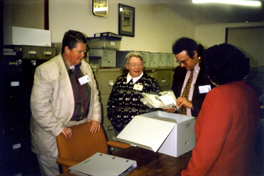
Photograph, Map Visit, 1/11/1999
Coloured photo of Map Representatives on Museum's Accreditation Inspection Visit, L-R - Jude Fraser, Barbara Gardiner (NDHS Secretary), Matthew Churchward, Elizabeth Triarico.schwerkolt cottage and museum complex, museums australia (vic). museum accreditation program, fraser, jude, gardiner, barbara, churchward, matthew, triarico, elizabeth -
 Whitehorse Historical Society Inc.
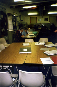
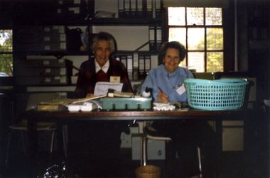
Photograph, Map Visit, 1/11/1999
Coloured photo of Society Volunteers working on cataloguing Artefacts on the occasion of Museum Accreditation Programme Reps visit for Inspection.museums australia (victoria). museum accreditation programme, schwerkolt cottage and museum complex -
 Whitehorse Historical Society Inc.
Photograph, Map Visit, 1/11/1999 12:00:00 AM
Coloured photo of Society Volunteers, Frances Warren and Margaret Skey working cataloguing Artefacts on the occasion of Museum Accreditation Inspection Visit.warren, frances, skey, margaret, museums australia (vic). museum accreditation program, schwerkolt cottage and museum complex -
 Whitehorse Historical Society Inc.
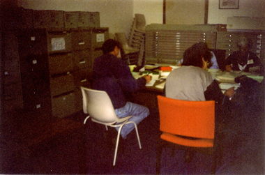
Photograph, Map Visit, 1/11/1999 12:00:00 AM
Coloured photo of Society Volunteers cataloguing Paper Collection on the occasion of Museum Accreditation Programme Inspection Visit.simmenauer, peter, crick, joan, museums australia (vic). museum accreditation program schwerkolt cottage and museum complex -
 Whitehorse Historical Society Inc.
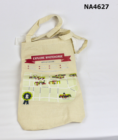
Memorabilia - Bag - Carrybag, 2013
Given away at 2013 City of Whitehorse Spring Festival, Whitehorse Civic Centre, Nunawading.Ecru calico carrybag printed on one side with 'Explore Whitehorse - Arts & Culture' in red headline. Underneath is a green map with numbers marking 1. Box Hill Community Arts Centre; 2. Whitehorse Art Space at Box Hill Town Hall; 3. Box Hill Library; 4. Blackburn Library; 5. Nunawading Library 6. Whitehorse Centre; 7. Vermont Library 8. Schwerkolt Cottage and Museum Complex; Contact details for Whitehorse City Council & Logo.City of Whitehorse; Explore Whitehorse-Arts & Culturecivic mementoes, souvenirs -
 Whitehorse Historical Society Inc.
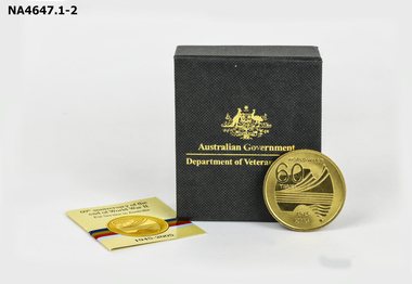
Memorabilia - Medallion, 2005
Medallion was minted to commemorate the 60th anniversary of the end of World War IIRound gold coloured medallion commemorating the 60th anniversary of the end of World War II. The front has a stylised map of Australia with 'World War II 60 years 1945-2005'. The back has the Australian Coat of Arms with 'World War II Service of Australia. The Medallion is contained in a black box with '60th anniversary of the end of World War II'. 'For Service to Australia'. A small brochure from The Royal Australian Mint.as above. On Box Australian Government - Department of Veterans' Affairs.military history, army -
 Whitehorse Historical Society Inc.
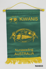
Banner - Kiwanis
The Kiwanis Club - Nunawading, a service club operated in the City of Nunawading and Whitehorse from 1979 to 2000. They were particularly involved with Winlaten Training Centre c. 1980.|ND6702 gives their history of community service.Green and Gold Kiwanis International Service Club Banner. Map of Australia with Kangaroo and KIWANIS logo inside left hand corner. Printed Schwerkolt Cottage Victoria. Logo in centre of banner - Nunawading Australia, in gold lettering near lower edge of gold fringe on lower edge of wood holder and gold cord for hanging banner.Printed by Screencraft Maynard.societies, service clubs -
 Whitehorse Historical Society Inc.
Banner
The Kiwanis Club - Nunawading, a service club, operated in the City of Nunawading and Whitehorse from 1979 to 2000. They were particularly involved with Winlaten Training Centre C. 1980.|ND6702 gives their history of community service.Purple and Gold Kiwanis International Service Club Banner. Printed Gold Map of Australia in centre of banner with Kiwanis logo inside map. Nunawading and Australia printed above and below map - wood holder and string cord for hanging.societies, service clubs -
 Whitehorse Historical Society Inc.
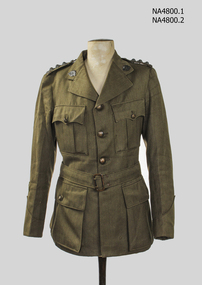
Uniform - Jacket Army, c1939
World War 2 Army uniform jacket worn by Captain Noel WestWorld War 2Army khaki tunic with cotton lining, sleeves have striped lining. Tunichas 2top pleated pockets with pointed flaps. Two more large expanding pockets with on bottom,4 buttons with Australia map and Aust Military Forces on front with one each on pocket. Shoulder strap has pips. One Australia badge and one AMF button on each side. Lapels have a rising sun badge on each lapel. Back has one pleat on bottom of jacket. Belt has rectangle buckle with 2bottom waist adjusters. Sleeve has a vee shape on cuff. Right sleeve has 2 vee stripes (long service) In pocket envelope with piece of ribbon from 1939/1945 Star, Pacific Star, and efficiency medalcostume, male uniform, military -
 Whitehorse Historical Society Inc.
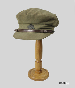
Clothing - Officers Army cap, c1939
Part of World War 2 army uniform worn by Captain Noel WestWord War 2|Australian War Graves UnitArmy Khaki officers peaked cap. Rising sun badge on front with narrow leather strap around front of cap. Small button on back end of strap which has a map of Australia engraved in the centre. Leather binding around inside of capLondon Stores Ltd. opp GPO Melb.costume, male uniform, military -
Whitehorse Historical Society Inc.
Map, Archaeological Sites, 1984
Australian Mutual Provident Society Calendar 1984. Includes table of types of sites associated with aboriginals of Victoria.Australian Mutual Provident Society Calendar 1984. Includes table of types of sites associated with aboriginals of Victoria.Australian Mutual Provident Society Calendar 1984. Includes table of types of sites associated with aboriginals of Victoria.aborigines, australian mutual provident society, archaeology -
Whitehorse Historical Society Inc.
Article, Aboriginal tribal boundaries of Victoria, n.d
Map of Victoria showing tribal names and boundaries in Victoria with comment on activities of the Christian Action Committee.Map of Victoria showing tribal names and boundaries in Victoria with comment on activities of the Christian Action Committee.Map of Victoria showing tribal names and boundaries in Victoria with comment on activities of the Christian Action Committee.aborigines, christian action committee -
Whitehorse Historical Society Inc.
Map, Aborigines of Bulleen, n.d
Map showing traces of Wurunngeri Tribe to be found in an area which became City of Doncaster and Templestowe, taken from history written by Irvine Green.Map showing traces of Wurunngeri Tribe to be found in an area which became City of Doncaster and Templestowe, taken from history written by Irvine Green.Map showing traces of Wurunngeri Tribe to be found in an area which became City of Doncaster and Templestowe, taken from history written by Irvine Green.aborigines, city of doncaster -
Whitehorse Historical Society Inc.
Map, Aboriginal sites in the City of Doncaster-Templestowe, 1/03/1991 12:00:00 AM
Map of City of Doncaster and Templestowe.Map of City of Doncaster and Templestowe showing location of stone artefacts and scarred trees.Map of City of Doncaster and Templestowe. aborigines, city of doncaster and templestowe -
Whitehorse Historical Society Inc.
Pamphlet, Aboriginal sites of Archaeological significance, 1/03/1991 12:00:00 AM
Illustrated pamphlet with map, photographs and articles.Illustrated pamphlet with map, photographs and articles.Illustrated pamphlet with map, photographs and articles.aborigines, barak, william -
 Whitehorse Historical Society Inc.
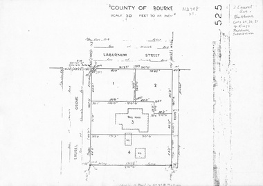
Map, Laurel Grove, 1959
Plan of subdivision, part of Crown Portion 84, Lots 29, 30, 31 Kings Paddock subdivision, cnr Laurel Grove and Laburnum Street, Blackburn. Ref 2713, 6/2/1959.laurel grove, blackburn, laburnum street, land subdivision, kings paddock -
 Whitehorse Historical Society Inc.
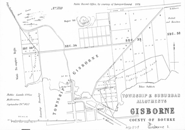
document - Map, Melbourne Metro, 1978
Collection of reproductions issued by the Public Record Office in 1978. Comprises: Allotments in the Black Forest, 1857; Township of Dandenong, 1856; Township and suburban allotments, Gisborne, 1857; Storing Yard allotments near the Melbourne Wharf, 1854; Town lots near the Railway Terminus, Melbourne, 1863; Parish of Prahran, 1853; Township of Sandridge, 1855; Township of Sunbury, 1857; River Yarra Yarra at the Queens Wharf, 1860.victoria. public record office, black forest, victoria, dandenong, gisborne, melbourne wharf, railway terminus, spencer street, melbourne, prahran, sandridge, sunbury, queens wharf -
 Whitehorse Historical Society Inc.
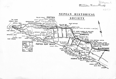
document - Map, Point Nepean, 1969
Map of Point Nepean showing historical sites, issued by the Nepean Historical Society, 1969.point nepean, victoria, nepean historical society -
Whitehorse Historical Society Inc.
Map, Yarra River, n.d
Copy of fold-out map 'Loddon 25' included in 'Lilydale', by Grace Aveling. Based on T.H. Nutt's original survey of the Yarra River, 1839.aveling, grace, nutt, t.h., yarra river