Showing 236 items
matching parish of sandhurst
-
 Bendigo Historical Society Inc.
Document - Notes on Dean John Christian MacCullagh (1982 - 1917), 5/09/2023
John Christian MacCullagh (5/6/1832 - 24/9/1917) Born in Ireland Dean MacCullagh came to Victoria in 1863 and was ordained as a minister in 1864 and his first posting was to Lancefield where he served as the first resident minister 1867-1870. Following the death of his young wife he moved to Bendigo in 1870 as the parish minister for St Pauls in Myers Street. At this stage the church was a long way from completion. 1872 made Canon 1877 Bishop's Canon 1883 rural dean 1883 Archdeacon of Sandhurst 1902 Dean of the diocese 1916 retired due to ill health 1917 Died in Melbourne and was buried at Lancefield. A triptych stained glass window at St Pauls stands as a memorial to his service of 47 years.Biography Six-page notes on the life and service of Dean John Christian MacCullagh. Typed pages.biography, dean maccullagh -
 Bendigo Historical Society Inc.
Map - MARKS COLLECTION: TRAMWAY OR RAILWAY MAP SANDHURST
Original map of 'land granted as endowment' for tramway or railway. On top Rh corner of map, in bold print 'Sandhurst, Inglewood & Loddon district Tramway or Railway.Land granted as endowment shaded, scale 60 chains to 1 inch. Lithographed by J & W. Holmes, Lith. Sandhurst'. Signed by Geo Avery Fletcher, Engineer. Map shows Parish of Leichardt, Parish of Yarraberb, Parish of Bridgwater and a section of Marong. On bottom RH corner, is small map of Sandhurst, showing railway reserve. Top LH corner, Inglewood. Map shows route of railway line from Sandhurst to Inglewood. -
 Bendigo Historical Society Inc.
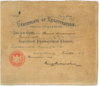
Document - David Anderson Chemist Certificate of Registration, Dec 20 1888
In 1891 to 1983 there were three chemists near View Point Bendigo; they were A. Collins, 9 View St and Pall Mall; G. M. Dorman at 25 View St; E. L. Holdsworth, 9 Charing Cross and J. Holdsworth at 15 Charing Cross and Pall Mall. On the 20 June 1892 David Anderson (1861-1937) took over from A Collins as Chemist and Druggist at 9 View Street, opposite the Bank of Victoria. He had been manager for the three previous years. In 1895 to 1908 the David Anderson Chemist was at View Point. David Anderson's father William (Willie) died on the 7th April 1901 at View Place. David Anderson was married to Jeanette (Jessie) Riviere, Ironbark. David's nephew Rae Alexander Anderson OAM (1903-1986) was connected to St Paul's Church and a pharmacist at the Bendigo Hospital. Rae was the organist and choir master of the parish church of St Paul, Bendigo, 1931 - 1965. Rae's son Stuart Anderson from the Balgownie Winery 1969-1999; had also been a pharmacist.Certificate of Registration (Pharmacy Act of Victoria, No 558}; for David Anderson, Sandhurst. The original certificate has been pasted to cardboard and possibly had been framed. It was found under a house after a sale in 1984.bendigo history, sandhurst victoria, david anderson chemist, collins, dorman, holdsworth -
 Bendigo Historical Society Inc.
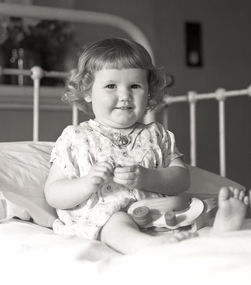
Photograph - Bendigo, the Old Hospital, 1935
Rae Alexander Anderson OAM (1903-1986) was connected to St Paul's Church and a pharmacist at the Bendigo Hospital. Rae was the organist and choir master of the parish church of St Paul, Bendigo, 1931 - 1965. Rae's son Stuart Anderson from the Balgownie Winery 1969-1999; had also been a pharmacist. Rae Anderson was a former President of the Royal Historical Society of Victoria, Bendigo Branch; now the Bendigo Historical Society. Rae died on the 8th. February, 1986 aged 82 years. He was a dedicated pharmacist; an outstanding musician; choir master and organist at St. Paul's Anglican Cathedral; a craftsman who loved to fashion things in wood and brass; interested tn the preservation of our heritage. Rae established "the Anderson Library" at the Society for reading and research.Eighteen Photos of the Bendigo Hospital - wards, pharmacist, nurses and general views. They were restored from a box of glass plate negatives found under a house in Mckenzie Street, Bendigo,.when it was sold. The photos are assumed to be taken by Rae Alexander Anderson and were processed through his pharmacy. One of the slides was maked 1935.bendigo history, sandhurst victoria, david anderson chemist, collins, dorman, holdsworth, rae anderson, st paul's church of england bendigo, bendigo hospital, stuart anderson -
 Bendigo Historical Society Inc.
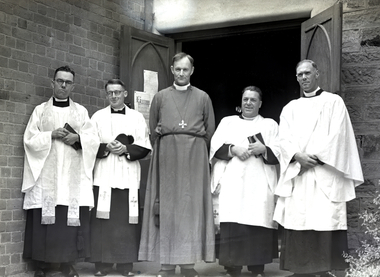
Photograph - St Paul's Anglican Cathedral Bendigo Photos from Glass Plate Negatives, 1935
Rae Alexander Anderson OAM (1903-1986) was connected to St Paul's Church and a pharmacist at the Bendigo Hospital. Rae was the organist and choir master of the parish church of St Paul, Bendigo, 1931 - 1965. Rae's son Stuart Anderson from the Balgownie Winery 1969-1999; had also been a pharmacist. Rae Anderson was a former President of the Royal Historical Society of Victoria, Bendigo Branch; now the Bendigo Historical Society. Rae died on the 8th. February, 1986 aged 82 years. He was a dedicated pharmacist; an outstanding musician; choir master and organist at St. Paul's Anglican Cathedral; a craftsman who loved to fashion things in wood and brass; interested tn the preservation of our heritage. Rae established "the Anderson Library" at the Society for reading and research.Eight Photos of clergy, also it is assumed, elders and Sunday School children; at St Paul's Anglican Cathedral. They were restored from a box of glass plate negatives found under a house in Mckenzie Street, Bendigo,.when it was sold. The photos are assumed to be taken by Rae Alexander Anderson and were processed through his pharmacy. One of the slides was marked 1935.bendigo history, sandhurst victoria, david anderson chemist, collins, dorman, holdsworth, rae anderson, st paul's church of england bendigo, bendigo hospital, stuart anderson -
 Bendigo Historical Society Inc.
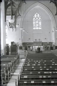
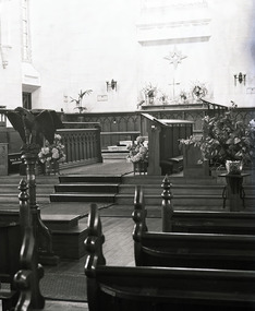
Photograph - St Paul's Church of England, Bendigo, 1935
Rae Alexander Anderson OAM (1903-1986) was connected to St Paul's Church and a pharmacist at the Bendigo Hospital. Rae was the organist and choir master of the parish church of St Paul, Bendigo, 1931 - 1965. Rae's son Stuart Anderson from the Balgownie Winery 1969-1999; had also been a pharmacist. Rae Anderson was a former President of the Royal Historical Society of Victoria, Bendigo Branch; now the Bendigo Historical Society. Rae died on the 8th. February, 1986 aged 82 years. He was a dedicated pharmacist; an outstanding musician; choir master and organist at St. Paul's Anglican Cathedral; a craftsman who loved to fashion things in wood and brass; interested tn the preservation of our heritage. Rae established "the Anderson Library" at the Society for reading and research.Sixteen Photos of the St Paul's Church of England. They were restored from a box of glass plate negatives found under a house in Mckenzie Street, Bendigo,.when it was sold. The photos are assumed to be taken by Rae Alexander Anderson and were processed through his pharmacy. One of the slides was marked 1935.bendigo history, sandhurst victoria, david anderson chemist, collins, dorman, holdsworth, rae anderson, st paul's church of england bendigo, bendigo hospital, stuart anderson -
 Bendigo Historical Society Inc.
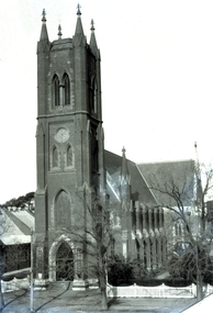
Photograph - St Paul's Church of England, Bendigo, 1935
Rae Alexander Anderson OAM (1903-1986) was connected to St Paul's Church and a pharmacist at the Bendigo Hospital. Rae was the organist and choir master of the parish church of St Paul, Bendigo, 1931 - 1965. Rae's son Stuart Anderson from the Balgownie Winery 1969-1999; had also been a pharmacist. Rae Anderson was a former President of the Royal Historical Society of Victoria, Bendigo Branch; now the Bendigo Historical Society. Rae died on the 8th. February, 1986 aged 82 years. He was a dedicated pharmacist; an outstanding musician; choir master and organist at St. Paul's Anglican Cathedral; a craftsman who loved to fashion things in wood and brass; interested tn the preservation of our heritage. Rae established "the Anderson Library" at the Society for reading and research.Seventeen Photos of the St Paul's Church of England. They were restored from a box of glass plate negatives found under a house in Mckenzie Street, Bendigo,.when it was sold. The photos are assumed to be taken by Rae Alexander Anderson and were processed through his pharmacy. One of the slides was marked 1935.bendigo history, sandhurst victoria, david anderson chemist, collins, dorman, holdsworth, rae anderson, st paul's church of england bendigo, bendigo hospital, stuart anderson -
 Bendigo Historical Society Inc.
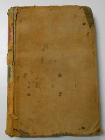
Document - LANDS OFFICE, CROWN LANDS SURVEYED AND SOLD SANDHURST DISTRICT, 1854 (?) onwards
Document: buff colour hard cover journal. Contains details of crown lands surveyed and sold. On LH page, town, suburban or country lands. RH page: auction, selection, price per acre, price and purchaser. Indexed by parish in front page. Two front pages cut out. On spine ' Index book' ' Lands and Survey' '06' 'E' ' Country' and 'Sales'Lands Officeplace, land sales, bendigo, lands office, land surveyed, land sold, sandhurst -
Bendigo Historical Society Inc.
Document - REGISTRATION OF RESIDENCE AREAS 9433 - 13296: 1899 - 1905, 1899 - 1905
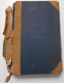
Document: hard cover journal, originally dark cover with burgundy binding on spine. In very poor condition, pages loose. Details: left hand page: date of registration, holder or owner, miners right etc., description of allotment, township or parish, memo, registration. Right hand page: same. Details land registrations in Bendigo and district.place, bendigo, land sales, bendigo, sandhurst, land sales, residence licences -
 Bendigo Historical Society Inc.
Photograph - St Paul's Church of England, Bendigo, 1935
Rae Alexander Anderson OAM (1903-1986) was connected to St Paul's Church and a pharmacist at the Bendigo Hospital. Rae was the organist and choir master of the parish church of St Paul, Bendigo, 1931 - 1965. Rae's son Stuart Anderson from the Balgownie Winery 1969-1999; had also been a pharmacist. Rae Anderson was a former President of the Royal Historical Society of Victoria, Bendigo Branch; now the Bendigo Historical Society. Rae died on the 8th. February, 1986 aged 82 years. He was a dedicated pharmacist; an outstanding musician; choir master and organist at St. Paul's Anglican Cathedral; a craftsman who loved to fashion things in wood and brass; interested tn the preservation of our heritage. Rae established "the Anderson Library" at the Society for reading and research.Eleven Photos of the St Paul's Church of England and an unknown dam. They were restored from a box of glass plate negatives found under a house in Mckenzie Street, Bendigo,.when it was sold. The photos are assumed to be taken by Rae Alexander Anderson and were processed through his pharmacy. One of the slides was marked 1935.bendigo history, sandhurst victoria, david anderson chemist, collins, dorman, holdsworth, rae anderson, st paul's church of england bendigo, bendigo hospital, stuart anderson -
 Bendigo Historical Society Inc.
Administrative record - LANDS OFFICE: APPLICATIONS FOR ALLOTMENTS FOR SALE 1869 - 1877, 1869 - 1877
Ledger. Hard cover journal, green cover with dark red spine and corners. Approx. 500 pages. LH page: date, parish, sec. allot. Area, applicant, address, valuation. RH page: owner of improvements, any other improvement on lot, upset price, remarks. On spine - 'applications for allotments for sale' and 'appn's for sale'.Lands Officeplace, land sales, bendigo, sandhurst -
 Bendigo Historical Society Inc.
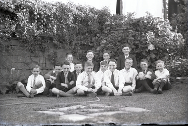
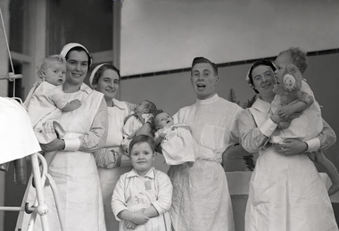
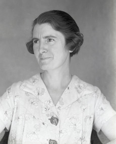
Photograph - Rae Alexander Anderson Family, Bendigo Hospital Photos, 1935
Rae Alexander Anderson OAM (1903-1986) was connected to St Paul's Church and a pharmacist at the Bendigo Hospital. Rae was the organist and choir master of the parish church of St Paul, Bendigo, 1931 - 1965. Rae's son Stuart Anderson from the Balgownie Winery 1969-1999; had also been a pharmacist. Rae Anderson was a former President of the Royal Historical Society of Victoria, Bendigo Branch; now the Bendigo Historical Society. Rae died on the 8th. February, 1986 aged 82 years. He was a dedicated pharmacist; an outstanding musician; choir master and organist at St. Paul's Anglican Cathedral; a craftsman who loved to fashion things in wood and brass; interested tn the preservation of our heritage. Rae established "the Anderson Library" at the Society for reading and research.Ten Photos from the Anderson Family. They were restored from a box of glass plate negatives found under a house in Mckenzie Street, Bendigo,.when it was sold. The photos are assumed to be taken by Rae Alexander Anderson and were processed through his pharmacy. One of the slides was marked 1935.bendigo history, sandhurst victoria, david anderson chemist, collins, dorman, holdsworth, rae anderson, st paul's church of england bendigo, bendigo hospital, stuart anderson -
 Bendigo Historical Society Inc.
Photograph - St Paul's Church of England, Bendigo, 1935
Rae Alexander Anderson OAM (1903-1986) was connected to St Paul's Church and a pharmacist at the Bendigo Hospital. Rae was the organist and choir master of the parish church of St Paul, Bendigo, 1931 - 1965. Rae's son Stuart Anderson from the Balgownie Winery 1969-1999; had also been a pharmacist. Rae Anderson was a former President of the Royal Historical Society of Victoria, Bendigo Branch; now the Bendigo Historical Society. Rae died on the 8th. February, 1986 aged 82 years. He was a dedicated pharmacist; an outstanding musician; choir master and organist at St. Paul's Anglican Cathedral; a craftsman who loved to fashion things in wood and brass; interested tn the preservation of our heritage. Rae established "the Anderson Library" at the Society for reading and research.Fifteen Photos of the St Paul's Church of England and an unknown dam. They were restored from a box of glass plate negatives found under a house in Mckenzie Street, Bendigo,.when it was sold. The photos are assumed to be taken by Rae Alexander Anderson and were processed through his pharmacy. One of the slides was marked 1935.bendigo history, sandhurst victoria, david anderson chemist, collins, dorman, holdsworth, rae anderson, st paul's church of england bendigo, bendigo hospital, stuart anderson -
 Bendigo Historical Society Inc.
Photograph - Rae Alexander Anderson Family, Bendigo, 1935
Rae Alexander Anderson OAM (1903-1986) was connected to St Paul's Church and a pharmacist at the Bendigo Hospital. Rae was the organist and choir master of the parish church of St Paul, Bendigo, 1931 - 1965. Rae's son Stuart Anderson from the Balgownie Winery 1969-1999; had also been a pharmacist. Rae Anderson was a former President of the Royal Historical Society of Victoria, Bendigo Branch; now the Bendigo Historical Society. Rae died on the 8th. February, 1986 aged 82 years. He was a dedicated pharmacist; an outstanding musician; choir master and organist at St. Paul's Anglican Cathedral; a craftsman who loved to fashion things in wood and brass; interested tn the preservation of our heritage. Rae established "the Anderson Library" at the Society for reading and research.Ten Photos of the Anderson Family. They were restored from a box of glass plate negatives found under a house in Mckenzie Street, Bendigo,.when it was sold. The photos are assumed to be taken by Rae Alexander Anderson and were processed through his pharmacy. One of the slides was marked 1935.bendigo history, sandhurst victoria, david anderson chemist, collins, dorman, holdsworth, rae anderson, st paul's church of england bendigo, bendigo hospital, stuart anderson -
 Bendigo Historical Society Inc.
Document - LANDS OFFICE REGISTER OF CROWN LANDS SOLD SANDHURST, 1855 - 1869
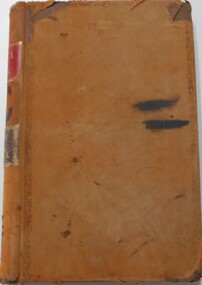
Journal: black hard cover journal with buff spine and corners. Front cover badly damaged Written on spine ' S.I. Sales 1855 - 1869' '05' written in red ink on top of spine. On front cover 'G.W. Groves' written in blue ink under torn cover. Blue lined pages contain details of crown lands surveyed in district of Sandhurst, town, suburban and country. Details of parish, area, date of sale, price and name of purchaser. Indexed by parish on first page.Lands Officeland sales, lands office, land sales, land surveyed, sandhurst, bendigo -
 Bendigo Historical Society Inc.
Document - LANDS OFFICE - CROWN LANDS SURVEYED AND SOLD SANDHURST - 1857 - 1879, 1857 - 1879
Journal: black hard cover with buff spine and corners. Contains details of crown land surveyed and sold, district of Sandhurst. Double pages numbered on top right, page columns - parish, town lands, particulars, survey fees, date of survey, date of sale, auction, selection price per acre, total amount, purchaser. No index. On spine '08' 'Bendigo A' 26th June 1857 to 1879 (?)Lands Officeplace, land sales, lands office, crown land, land surveys, bendigo, sandhurst -
 Bendigo Historical Society Inc.
Document - LANDS OFFICE - CROWN LANDS SURVEYED AND SOLD SANDHURST, 1860 onwards
... of Sandhurst. Indexed in front by parish, alphabetical double pages... and sold in the district of Sandhurst. Indexed in front by parish ...Journal: LANDS OFFICE - CROWN LANDS SURVEYED AND SOLD SANDHURST green hard cover journal with buff spine and corners. Contains details of crown land surveyed and sold in the district of Sandhurst. Indexed in front by parish, alphabetical double pages not numbered. On LH page, parish, town, suburban, country, date of survey. On RH page, date of sale, auction, selection, price, total amount, purchaser. On spine ' index book' 'F' and '09'. Dated from 1860 onwardsLands Officeland sales, bendigo -
 Bendigo Historical Society Inc.
Document - LANDS OFFICE - SALE OF CROWN LANDS - 1864 - 1869, 1864- 1869
Journal: LANDS OFFICE - SALE OF CROWN LANDS - 1864 - 1869 Brown hard cover journal. Contains details of sales of crown land, listed in chronological order of sales. Includes lot, allotment, section, county, parish, area, upset price per acre, deposit, amount for which sold, valuation, name of purchaser. On spine 011Lands Officelands office, crown land, crown land sales, land sales, bendigo, sandhurst -
 Bendigo Historical Society Inc.
Document - LANDS OFFICE, REPORTS OF SALES BY PUBLIC AUCTION, 1864 - 1892
Document: buff leather hard covered journal. On spine on red rectangle ' Land sales by public auction' written in gold. On bottom of spine 'Lands and Survey' written in gold on black. On base of spine '4' printed in black. Pages contain details of sales of crown lands by public auction Act 25, Victoria 145. Alphabetical index of counties inside front cover. 443 numbered pages. LH side columns, number, county, parish, section, allotment sold, unsold, price. RH page - improvements, purchaser, residence, amount, later sales have printed notices pasted in. Dated 27 April 1864 to 7 October 1892.Lands and Survey Dept.place, bendigo, sandhurst, crown land, public land auctions, land sales. -
 Bendigo Historical Society Inc.
Document - LANDS OFFICE, CROWN LOTS SURVEYED AND SOLD IN THE SANDHURST DISTRICT 1857 - 1905, 1857 - 1914
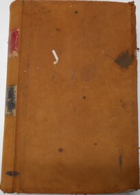
Document: blue hard cover journal with buff spine and corners. (spine in poor condition, frayed and pieces missing) Contains details of crown lands surveyed and sold in Sandhurst district. LH page: town, suburban or country lands. RH page: auction, selection, price per acre, price overall and purchaser. Indexed by parish inside front cover. On spine ' Index book' ' Lands and Survey' '07' written on spine under damaged spine cover. Dated from 26/6/1857 to 24 February 1914Lands Officeland sales, lands office, land surveyed, land sold, bendigo, sandhurst -
 Bendigo Historical Society Inc.
Document - LANDS OFFICE, CROWN LANDS SURVEYED AND SOLD, 1860/70
Document: buff hard cover journal, embossed on borders. On spine 'Lands and Survey' 'Index Book' and '03'. Contains list of parishes in front cover, indexed to page numbers which describes land surveyed and sold in parishes. Double page entries. 230 pages in book. LH page ' town lands, suburban lands, country lands, total lands surveyed, date of survey. RH page: date of sale, by auction, by selection, price per acre, total amount name of purchaser.Lands Officeland sales, lands office, land surveyed, land sold, bendigo, sandhurst -
 Bendigo Historical Society Inc.
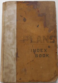
Document - LANDS OFFICE, - INDEX TO CROWN LANDS SURVEYED AND SOLD IN THE DISTRICT OF SANDHURST
Document: Buff hard cover book, with fawn coloured binding on spine (later addition to mend spine?) On front cover drawn in black pen ' PLANS' and 'Index Book' On spine written in black ink ' plans index book'. Contains index of parishes in front of journal with 470 pages indexed to parishes. Double page entries: LH side page: town, suburban or country lands, total lands surveyed. Date of survey. RH page: allotment, section, particulars, no. page. Entries are not dated.Lands Officeland sales, lands office, land surveyed , land sold, bendigo, sandhurst -
 Bendigo Historical Society Inc.
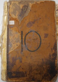
Document - LANDS OFFICE, INDEX OF CORRESPONDENCE INWARDS 1861 ONWARDS, 1861
Journal: buff coloured hard cover journal with ruled pages containing details of inward correspondence. Spine is badly degraded and frayed. On front cover '10' written in black pen. White sticker with '07A' on front. Index of letter A-Z in front. Section after index has columns: local office No., date received, name, subject, instructions, how disposed of, on numbered pages. Loose pages inserted - more indexes, Mallee parishes in Bendigo Lands District.Lands Officeorganisation, government, lands office, land sales, bendigo, sandhurst -
 Bendigo Historical Society Inc.
Document - LANDS OFFICE: SANDHURST LISTS OF ALLOTMENTS SOLD 1854 - 1856, 1854 - 1856
Document: LANDS OFFICE: SANDHURST LISTS OF ALLOTMENTS SOLD 1854 - 1856 Sandhurst lists of allotments sold, dated 1854 - 1856. Sandhurst land sales outlying districts 1854 -1861. Loose pages in plastic pockets, blue lined, formerly in register that has degraded and not repairable. Lists of date of sale, no. of lot, parish, allotment, section, extent (size) purchasers name.Lands Officeland sales 1854, lands office, sandhurst, bendigo -
 Bendigo Historical Society Inc.
Document - LANDS OFFICE: SANDHURST AND DISTRICT LAND SALES 1865 - 1869, 1865 - 1869
Document: green hard cover journal with buff spine and corners. Contains details of land sales. Details on LH page: date, parish, section, allotment, area, applicant, val. asked. RH page: val. allowed owner of improvements., remarks. Dates range from 10th. January 1865 to 1869.Lands Officeland sales 1865 - 1869, sandhurst, bendigo, land sales, lands office. -
 Bendigo Historical Society Inc.
Document - LANDS OFFICE: CROWN LAND SALES 1855 - 1857, 1855 - 1857
Document: LANDS OFFICE: CROWN LAND SALES 1855 - 1857 brown hard covered journal with buff corners and spine. Contains 200 pages with details of crown land sales. LH page: lot, sec., allotment, county, parish, area, upset price, deposit, amount RH page: val. name of purchaser, name of owner of improvement, remarks.Lands Officeland sales 1855 - 57, lands office, sandhurst, bendigo, land sales, crown land