Showing 237 items
matching the victoria quartz mine
-
 Bendigo Historical Society Inc.
Document - BENDIGO MINES 1906
Handwritten notes mentioning Bendigo Mines. Four mines, Garden Gully United, South New Moon, Hustlers Reef and Catherine Reef United have some information about them. Others listed are: Catherine Reef United, Carlisle, Clarence United, Central Ellesmere, Collman & Tacchi, Confidence Extended Cornish United, Ellenborough, Extd South Devonshire, Eureka, Fortuna Hustlers, Garden Gully United, G G Consolidated, Geribaldi, Great Southern, Gt Northern, Gt Extended Hustlers, Gt Central Victoria, Golden Age, Golden Pyke, Goldfields North, Goldfields Consolidated, North Johnsons, Pearl, Princess Dagmar, Phoenix, Railway Prince of Wales, Shamrock, St Mungo, Sadowa, Sea, Specimen Hill Sth St Mungo, South New Moon, South Devonshire, Suffolk United, United Devonshire, Unity, United Hustlers & Redan, United Ulster, Victoria Consols, Victoria Quartz, Pansora, Virginia, Victoria Proprietory, Williams United, Hustlers Reef, Hustlers Royal Reserve, Hercules & Energetic, Ironbark, Johnsons Reef No 1, Hustlers Royal Reserve, Ironbark, Johnsons Reef, Johnsons Extended, Kochs Pioneer, Lazarus New Chum, Lady Barkly - Lightning Hill, McDuff Amalgamated, Morning Star, New Chum Consolidated, New Chum Railway, New Chum & Victoria, New Blue Consolidated, New Hopefu, New St Mungo, New Argus, New Moon, New Victoria Catherine, New Chum Goldfields, North New Moon and North Argus. Document from Albert Richardson Collection of mining history.document, gold, bendigo mines 1906, bendigo mines 1906, catherine reef united, carlisle, clarence united, central ellesmere, collman & tacchi, confidence extended cornish united, ellenborough, extd south devonshire, eureka, fortuna hustlers, garden gully united, g g consolidated, geribaldi, great southern, gt northern, gt extended hustlers, gt central victoria, golden age, golden pyke, goldfields north, goldfields consolidated, north johnsons, pearl, princess dagmar, phoenix, railway prince of wales, shamrock, st mungo, sadowa, sea, specimen hill sth st mungo, south new moon, south devonshire, suffolk united, united devonshire, unity, united hustlers & redan, united ulster, victoria consols, victoria quartz, pansora, virginia, victoria proprietory, williams united, hustlers reef, hustlers royal reserve, hercules & energetic, ironbark, johnsons reef no 1, hustlers royal reserve, ironbark, johnsons reef, johnsons extended, kochs pioneer, lazarus new chum, lady barkly - lightning hill, mcduff amalgamated, morning star, new chum consolidated, new chum railway, new chum & victoria, new blue consolidated, new hopefu, new st mungo, new argus, new moon, new victoria catherine, new chum goldfields, north new moon, north argus, bgo library 'healthy golden bendigo' - 1906 -
 Bendigo Historical Society Inc.
Document - NOTES ON BENDIGO MINES
Handwritten notes on Bendigo Mines. Notes include area of lease, yards along the reef, depth, dividends, main shafts within one mile of Bendigo Station and shafts made safe by the Mines Dept. Mines mentioned are: South New Moon, Carlisle, Nth Garden Gully, Passby, Old Carlisle,Kentish, Central Garden Gully, Golden Fleece, Garden Gully United, Big Blue, Union Co, Red, White & Blue, New Chum Railway, Unity, Cornish, Catherine Reef United, Garden Gully United, Gt Extended Hustlers, Gt Northern, Lady Barkly, New Moon, South St Mungo, Virginia and Victoria Quartz, Document from Albert Richardson Collection of mining history.document, gold, notes on bendigo mines, notes on bendigo mines, south new moon, carlisle, nth garden gully, passby, old carlisle, kentish, central garden gully, golden fleece, garden gully united, big blue, union co, red, white & blue, new chum railway, unity, cornish, catherine reef united, garden gully united, gt extended hustlers, gt northern, lady barkly, new moon, south st mungo, virginia, victoria quartz, graham, tenby and ashman, mr j b watson, geo lansell, mines dept, d e thomas -
 Bendigo Historical Society Inc.
Document - DRAINAGE PROBLEMS - VICTORIA REEF QUARTZ HALF=YEARLY MEETING
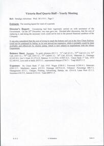
Handwritten extract of the Victoria Reef Quartz Half-Yearly Meeting from the Bendigo Advertiser Wed 18/1/1911 Page 5. The meeting lapsed for want of a quorum. Director's Report states unwatering had been vigorously carried on with assistance of the Government. On 20 December, one rope gave out. After discussion, it was decided it was too costly to replace with the present financial condition of the Company. It was also considered that the cost of trying to reach the bottom reef cut in the New Chum Railway could not be continued by baling, as its cost proved too expensive, while it probably could be done profitably and effectively by electric pump, which is now subject to negotiations with the Mines Department.'' Also included is a Balance Sheet. From the Albert Richardson Mining History Collection.document, gold, drainage problems, drainage problems, victoria reef quartz half-yearly meeting, bendigo advertiser, 18/1/1911 page 5, new chum railway, mines department, balance sheet victoria reef quartz, ar -
 Bendigo Historical Society Inc.
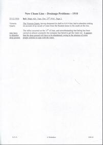
Document - DRAINAGE PROBLEMS - NEW CHUM LINE DRAINAGE PROBLEMS 1910
Handwritten extract from the Bendigo Advertiser 27/12/1910 Page 2. ''The Victoria Quartz, having deepened its shaft to 4,614 feet, had to abandon sinking on account of an inrush of water from the flooded mines to the south on the line. The influx occurred on the 15th of June, and notwithstanding that baling has been carried on almost constantly the company has failed to get the water out. It appears that the deep ground will have to be abandoned, owing to the absence of some proper scheme to cope with the water.'' Albert Richardson Mining History Collection.document, gold, drainage problems, drainage problems, new chum line drainage problems 1910, bendigo advertiser 27/12/1910 page 2, victoria quartz, albert richardson -
 Bendigo Historical Society Inc.
Document - DRAINAGE PROBLEMS - DRAINAGE 1905 - 1908
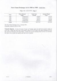
Handwritten notes from the Bendigo Advertiser 22/6/1910, listing the mine, Gallons baled, Deepest depth baled from, Total amount Rec'd, ? ? Coy for Financial Year ended 30/6/1908. Mines mentioned are: New Chum Railway, Eureka Ext'd, New Chum Con'd, Lazarus, Garibaldi, Lansells 180, Victoria Quartz, Lansell's 222, New Chum & Vic., Shamrock and New Shenandoah. Note along the side: re - Vict Quartz Inrush Water. Adv. Wed. 22/6/1910. (b) Handwritten notes on the New Chum Drainage Ass'n 1905 - 1908 from the Bendigo Advertiser 22/6/1910. Listed is the Year, Water Raised (Gallons), Total Amount Re?ed and Amount Re? Coys. The New Chum Drainage Ass'n was formed in 1901 and practically ceased to exist in 1908. Victoria Quartz at time of inrush of water on Tuesday night, the shaft had reached a depth of 4,614 feet. Water has since risen in the shaft to above 4,154 ft plat & the large workings at 4,254 feet, and 4,154 feet have also been t filled. As there are no reef workings from 4,154 to 3,424 feet the water will no doubt rise rapidly until that level is reached. Document from Albert Richardson Collection of mining history.document, gold, drainage problems, new chum drainage association, drainage 1905 - 1908, bendigo advertiser 22/6/1910, victoria quartz, new chum railway, eureka ext'd, new chum con'd, lazarus, garibaldi, lansell's 180, lansell's 222. mew chum & vic, shamrock, new shenandoah -
 Bendigo Historical Society Inc.
Document - DRAINAGE PROBLEMS - DRAINAGE 1905 - 1908
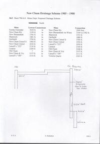
Two handwritten pages naming the mine, the lowest connection and connection to the next mine for the proposed drainage scheme. The second page lists the mines, from South to North, the projected distances in feet and to the nearest yard. Document from Albert Richardson Collection of mining history.document, gold, drainage problems, new chum drainage scheme, drainage 1905 - 1908, mines dept sheet 796/a/6 proposed drainage scheme, south belle vue, eureka ext'd, new chum railway, new shenandoah, shamrock, garibaldi, new chum consol'd, new chum united, lansell's 222, lazarus, old chum ?, new chum & vic, lansell's 180, victoria quartz -
 Bendigo Historical Society Inc.
Document - DRAINAGE PROBLEMS - BAILING OPERATIONS
Handwritten extracts from the Bendigo Advertiser 17/8/1910 Col. 2. Extract mentions Bailing Operations - A Week's Progress. Water at the Victoria Quartz lowered 139 ft for the week. Bailing carried out at Lansell's 180, Lazarus, New Chum Consolidated and New Chum Railway Mines. Cost of bailing about 200 pound per week and the Government is contributing half. The balance is being found from the Victoria Quartz, Victoria Consols, Ironbark, Hercules and Energetic and Lansell's Estate. Expenditure over 6 weeks has amounted to over 1200 pounds. ''Mr McBride, Minister for Mines,said work was to be continued for the present at all events. Mr Merrin, Chief Inspector of Mines, said the Dept's aim was to keep the whole of contributing mines on the New Chum line unwatered, and also to enable the Victoria Quartz to go on with its sinking. It was not however intended to introduce a pumping system for the present.''document, gold, drainage problems, drainage problems, bendigo advertiser 17/8/1910 page 3 col 2, victoria quartz, lansell's 180, lazarus, new chum consolidated, new chum railway, victoria consols, ironbark, hercules and energetic, lansell's estate, mr mcbride, mr merrin, new chum line -
 Bendigo Historical Society Inc.
Document - BENDIGO ADVERTISER - NOTES ON VICTORIA QUARTZ
... Victoria Quartz Mine Explosion... on Victoria Quartz Victoria Quartz Mine Explosion Bendigo Advertiser ...One typed and one handwritten copy of articles from the Bendigo Advertiser. Items mentioned are a man killed in an explosion at the mine, yields of gold at various depths, ventilation at the mine and a new discovery.document, gold, victoria quartz, victoria quartz, notes on victoria quartz, victoria quartz mine explosion, bendigo advertiser 11/7/1905, lansell's 180 tribute, bendigo advertiser mining intelligence 3/8/1908, crushings - bendigo advertiser17/8/1908, ventilation at the victoria quartz - bendigo advertiser 17/9/1908, victoria quartz - a reef at 4504 feet - bendigo advertiser mining intelligence 29/8/1908 -
 Bendigo Historical Society Inc.
Document - VICTORIA QUARTZ - EXTRACT FROM OUR 'MINES' NEW CHUM & DEVONSHIRE LINE
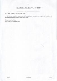
... DOCUMENT Gold victoria quartz Victoria Quartz Extract from ...Handwritten extract from Our Mines New Chum & Devonshire Line. Written on the paper is: Miner Killed Sth Belle Vue 19/2/1894. Great Central Victoria - Adv 3/7/1899 Page 3. Has worked steadily to get down to the Victoria Quartz formation; but progress has been slow on account of hand labour being in vogue on the mine. Extract from Our'Mines' New Chum & Devonshire Line.document, gold, victoria quartz, victoria quartz, extract from our 'mines' new chum & devonshire line, sth belle vue, great central victoria, our 'mines' new chum & devonshire line -
 Bendigo Historical Society Inc.
Document - VICTORIA QUARTZ - MINE MANAGER'S REPORTS 1886-87 YIELDS
... VICTORIA QUARTZ - MINE MANAGER'S REPORTS 1886-87 YIELDS... Victoria Quartz Mine Manager's Reports 1886-87 Yields... from the surface. Document VICTORIA QUARTZ - MINE MANAGER'S ...Typed copy and a handwritten copy of the Victoria Quartz Manager's Reports, 1886-87 Yields. Items mentioned are: depth from the surface, type of stone, crushings and depth of Plat Nos 1 to 13 from the surface.document, gold, victoria quartz, victoria quartz, victoria quartz mine manager's reports 1886-87 yields, samuel renfrey, 180 boundary -
 Bendigo Historical Society Inc.
Document - VICTORIA QUARTZ - NOTES ON VICTORIA QUARTZ
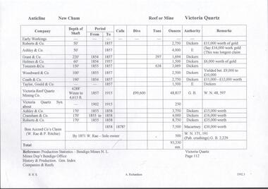
Handwritten page of notes listing Company, Depth of Shaft, Years and Ounces of Gold, Names of Companies listed: Roberts & Co, Ashley & Co, Grant & Co, Holmes & Co,Touzeau & Co, Woodward & Co, Coath & CO, Taylor Gould & Co, Victoria Reef Quartz Mining Co, Victoria Quartz Syn, Cranshaw & Co and Bon Accord Co.document, gold, victoria quartz, victoria quartz, notes on victoria quartz, roberts & co, ashley & co, grant & co, holmes & co, touzeau & co, woodward & co, coath & co, taylor gould & co, victoria reef quartz mining co, victoria quartz syn, cranshaw & co and bon accord co, dickers, macartney, w rae, p ritchie, production statistics - bendigo mines n l, mines dept bendigo, history & production gen index of companies & reefs -
 Bendigo Historical Society Inc.
Document - MINING REPORTS - LOCATION OF SHAFT WITH THE REEF
... Gold Mines) Victoria Consols Victoria Quartz (Vict Reef ...BHS CollectionHandwritten list of mines on the Garden Gully, Sheepshead, Hustlers, Nell Gwynne and the Deborah, Paddy Gully and Derby Lines of Reef. Also a list of prominent mines on the New Chum Line.document, gold, mining reports, mining reports, location of shaft with the reef, north new moon, suffolk, new moon, south new moon, clarence, new argus, virginia, gt northern golden pyke, constellation, johnsons extd, golden age, princess dagmar, johnson's no 2, nth johnsons, johnsons no 1, confidence extended, windmill hill, koch's pioneer, cornish, carlisle, pandora, garden gully united, catherine reef united, williams united, belmont & saxby, ellenborogh, st mungo, sadowa, lady barkly, south st mungo, united devonshire, south devonshire, pearl, hercules & energetic, ironbark (vict gold mines), victoria consols, victoria quartz (vict reef), lansell's big 180, north old chum, new chum & victoria, old chum, lazarus, 222, new chum united, new chum consolidated - the consolidated, garibaldi, shamrock, hercules, ironbark, south ironbark, little 180, central blue, sheepshead, nth blue, big blue, south blue (lansell's), united hustlers & redan, the redan, comet (lansell's), hustlers reef plus no 1 shaft, old hustlers, gt extended hustlers plus 'pups', royal hustlers reserve nos 1 & 2, fortuna hustlers, new chum syncline, central nell gwynne, monument hill, central deborah, north deborah, deborah, collman &tacchi, lansells sandhurst needle, johnsons no 3 (nelsons) -
Bendigo Historical Society Inc.
Document - MINING IN BENDIGO COLLECTION: LIST OF LEADING MINES
BHS CollectionHandwritten list of leading mines and dividend paying mines from the Annals 1889, 1890, 1891 and 1909 includes companies over 2000 feet on 31st March 1891.document, gold, mining in bendigo, mining in bendigo, list of leading mines, annals, great extended hustlers, catherine united, garden gully united, hercules & energetic, johnsons reef, lazarus no 1, new chum consolidated, north johnsons, north argus united, rose of denmark, shamrock, st mungo, specimen hill united hustlers & redan, united devonshire, watson's kentish, johnsons reef no 1, dixon's tribute, fortuna hustlers, lady barkly, lazarus, new chum railway, new red white & blue, north old chum, confidence, golden age, hustlers reef, new hopeful, new argus, new chum united, virginia, carlisle, catherine reef united tribs, collman & tacchi, goldfields consolidated, hercules & energetic tribs, horwood & burrowes, koch's pioneer, koch's pioneer tribs, new chum goldfields, new red white & blue tribs, new prince of wales, new prince of wales tribs, new moon, n bendigo, suffolk united, suffolk united tribs, south new moon, the langdon, victoria propty, victoria consols, victoria consols tribs, windmill hill, windmill hill tribs, lansells 180, north old chum, victoria quartz, victory & pandora, new chum & victoria, old chum, ironbark, shenandoah, lansell's 222, garibaldi, eureka, great central -
 Clunes Museum
Photograph, 1866 - 1867
.1 SEPIA PHOTOGRAPH MOUNTED ON CARDBOARD OF CRITERION QUARTZ MINE, CLUNES. .2 SEPIA PHOTOGRAPH MOUNTED ON CARDBOARD .3 SMALL BLACK AND WHITE PHOTO PRINT .4 ONE MEDIUM SIZE BLACK AND WHITE COPY .5 BLACK AND WHITE PHOTO PRINT .6 MOUNTED BLACK AND WHITED PRINT CRITERION QUARTZ MINING COMPANY, REGISTERED, CLUNES. HANDWRITTEN NOTES: PERIOD 1865, ON FLAT GROUND BELOW PORT PHILLIP HILL CREEK BROKE THROUGH INTO WORKINGS ABOUT 1861 VARIOUS NOTATIONS MARKING LOCATION OF BUILDINGS IN CLUNES, INCLUDING PICKFORDS STORE, VICTORIA HOTEL, CAMP HILL, ALBION HOTEL, CRITERION HOTEL, COMMERCIAL HOTEL, BOOT SHOPlocal history, photography, photographs, mining -
 Bendigo Historical Society Inc.
Document - Hustlers, Sheepshead and Deborah lines of reef
Albert Richardson was a mining historian who wrote widely on the mines of the Bendigo Goldfield. The park opposite the Goldmines Hotel in Marong Road, is named in his honour. Five page document, hand written by Albert Richardson on lined foolscap and edited with cross-outs and insertions, . The mines along the Hustlers line of reef and the Sheepshead line of reef are described. Mines listed on Hustlers line of reef: Fortuna Hustlers (1888 - 1913), shaft 2,240 feet at rear of Buckell and Jeffrey's offices; Royal Hustlers Reserve No. 2 - two shafts 'City" 860 feet, now covered by R.S.L. building Pall Mall, steel poppet legs 60 ft high and 'Park Shaft" at rear of Camp Hill School, 1,775 feet, steel poppet legs 60 feet high; Hustlers Hill Group first worked by Jonathan Harris in 1853 and bounded by Valentine, Anderson and Ironbark Creek to the north and Milroy Street to the east, one of first areas worked for quartz reefing. It with Garden Gully line west and Victoria Hill Ironbark, formed by far the richest cross section of the Bendigo Goldfield. Great Extended Hustlers (1865-1921) close to intersection of Anderson Street and Hustlers Road, mullock heap against road and shored up around shaft, steel poppet legs now at Wattle Gully mine, Chewton, large winding machine, air compressor south of shaft and 36 head crushing battery. Hustlers Reef (Old Hustlers) and Hustlers Reef No. 1, two shafts, main 2,210 feet, about 220 yards east of Moran Street and against Fenton Street. , No. 1 shaft 1,140 feet and about 155 yards east of Moran Street. Lansell's Comet, Lightining Hill line, 2.100 feet, on Comet Hill approx 70 yards west of Holmes Road, near Comet Creek, steel poppet legs. United Hustlers and Redan (1876-1918), main Redan, 1,830 feet about 155 yards west of Sandhurst Roead, in line with Comet Hill State School, this hill known as Redan Hill. North, or New Hustlers, once known as Agnew Hustlers, wooden poppet legs, south side, Kneebone Street, Eaglehawk. Derby line, Johnson's No. 3, South Johnson's (east shaft of Collman and Tacchi) 439 feet on west wide of Woods Street, south of Wetherall Street. Paddy's Gully Line, south to north, some shafts - Lansell's 'Sandhurst" ('Needle") Eaglehawk Road shaft 2,425 feet, about 50 yards east of Needle Loops, a brick square sided chimney with Cleopatra Needle top. British American, 789 feet, just south of Holdsworth Road. Collman and Tacchi, main shaft 2,588 feet, 60 yards west of Eaglehawk Road, California Gully. Deborah Line of Reef, The Deborah (1932-1954) shaft 2.017 feet, west of Adams Road and south of Abel Street, Quarry Hill. North Deborah (1937 - 1954) shaft 1,151 feet, Breen Street, Quarry Hill, steel poppet legs. Central Deborah (1939-1954) shaft 1,347 feet Sheepshead line of reef, Lansell's South Red, White and Blue, shaft 2,124 feet, north east of Bellevue Road and 220 yards east of Adams Road. The New Red, White and Blue Consolidated (Big Blue) main shaft 2,416 feet. Lansell's Bendigo Battery 105 head, north of 'Big Blue" on his freehold lease, commenced crushing on 24th February 1895. After closing was erected as the Showground's Industrial Hall, July 1926. North Red, White and Blue, burnt down February 1926, new company 1934, closed 1938. Document is part of the Albert Richardson Collection of Bendigo mining history. bendigo, gold mining, deborah line of reef, sheepshead line of reef, hustlers line of reef, royal hustlers reserve mine, hustlers hill group of mines, great extended hustlers, hustlers reef no. 1, lightning hill line, old comet, collman and tacchi, lansell's comet, north deborah, central deborah, dhrrpdhrsf linr og trrg, new red, white and blue consolidated mine, big blue, lansell's bendigo battery, north red, white and blue mine, albert richardson collection -
 Bendigo Historical Society Inc.
Document - ULSTER GOLD MINING COMPANY NO LIABILITY - UNITY MINE FIRE 8/10/1907 & FAMOUS GOLD MINES
... Victoria Quartz Mine... Hustlers Line Victoria Quartz Mine New Chum Railway Mines Report ...Typed copy of recount by Albert Richardson of a fire at Unity Mine on Tuesday 8-10-1907. Report from the Bendigo Advertiser Wednesday October 9th 1907. Notes mention Fire Brigade, miners, how the fire started and how the men down the shaft escaped when the rope crash down the shaft. On the back is a handwritten carbon copy of notes titled Famous Gold Mines of Bendigo and Eaglehawk. Notes give yields of gold for alluvial and quartz mining. Deep Shafts in 1904 of which there were eleven with a depth of more than 3000 feet and 53 over 2000 feet and two which were more than 4000 feet. Wages for 1911 for Engine Drivers and Firemen and Boiler Attendants. Note on winding plants and air compressors.document, gold, ulster gold mining coy no liability, ulster gold mining company no liability, unity mine fire 8/10/1907, bendigo advertiser 9/10/1907, garden gully reef hotel, wm addicoat, louis pabst, edward morris, conrad inglefinger, edward fuller, frederick allen, wm whitford, mr jewell, carlisle mine, famous gold mines of bendigo and eaglehawk, new chum line, garden gully line, hustlers line, victoria quartz mine, new chum railway, mines report 1911 p15, albert richardson -
Clunes Museum
Photograph - PHOTOGRAPH CLUNES 1860, CIRCA 1860
COLLAGE - CLUNES IN THE 1860's SIX REPRODUCED PHOTOGRAPHS MOUNTED IN WOODEN FRAME WITH BOLD EMBOSSED TRIM. CRITERION QUARTZ MINING COMPANY, PORT PHILIP & COLONIAL GOLD MINING COMPANY, VICTORIA QUARTZ MINING COMPANY. VIEW OF CAMP HILL , VIEW OF PORT PHILIP MINE SIGHT, VIEW OF THE LEVEL SITE OF BATTERY SEEN ON THE SITE ALONG STATION FLAT ROAD.local history, photographs, mining and township -
 Eltham District Historical Society Inc
Photograph - Digital Photograph, Marguerite Marshall, One Tree Hill Mine, Smiths Gully, 8 June 2006
Gold was discovered on One Tree Hill in 1854. The site has been worked intermittently until fairly recent times. Published: Nillumbik Now and Then / Marguerite Marshall 2008; photographs Alan King with Marguerite Marshall.; p53 Though still a working mine, One Tree Hill Mine at Smiths Gully, now stands in a tranquil reserve surrounded by bush and native animals - in contrast to its heyday. In the mid 19th century, when the mine was part of the Caledonia Goldfields, hundreds of men in search of their fortune worked the alluvial gold in the Yarra River, its tributaries and the reefs that made up the goldfields. Miner Stan Bone, assisted by Wilfred Haywood, is the last of the independent gold miners in the area and still uses the quartz crushing battery as miners did when gold was first discovered in the area in 1851.1 Stan, who is the last of six generations of miners in his family, was aged 17 when he began mining on his father Alex’ mine, The Golden Crown in Yarrambat. These days, after blasting the gold-bearing rock in Mystery Reef, one of the four reefs at One Tree Hill, Stan transports it around five kilometres by tip truck to the Black Cameron Mine for crushing. There he uses water from the waterlogged mine, (which still contains gold), as the Happy Valley Creek at One Tree Hill is usually dry.2 The One Tree Hill Mine has been worked for close to a century since it opened around the late 1850s.3 The Swedish Reef was its most productive reef and one of the largest in the area. Around 1859, extractions included 204 ounces (5.8kg) of gold, won from 57 pounds (26kg) of stone.4 Then during World War Two, Stan’s uncle, Bill Wallace, and Alex Bone, closed the mine. In 1973, Stan, with his Uncle Bill, reopened the Black Cameron Mine and worked there until 1988. Stan resumed mining One Tree Hill in 1998. As late as the 1920s gold was picked up by chance! When crossing a gully on his way to vote at the St Andrews Primary School, Bill Joyce picked up some quartz containing gold. This site was to become the Black Cameron Mine. The Caledonia Diggings, named after Scotland’s ancient name by local Scots, began around Market Square (now Smiths Gully) and included Queenstown (St Andrews), Kingstown (Panton Hill) and Diamond Creek. There were also poorer bearing fields in Kangaroo Ground and Swipers Gully (now Research). * None of these compared in riches to the Ballarat and Bendigo fields5, but the Caledonia Diggings continued intermittently for close to 100 years. Gold was discovered in Victoria following a bid to stem the disappearance of much needed workmen to the New South Wales diggings. Several businessmen offered a reward of £200, for the discovery of gold within 200 miles (322 km) of Melbourne. Late in June 1851, gold was first discovered at Andersons Creek, Warrandyte. Then in 1854, George Boston and two other men discovered gold at Smiths Gully. Gold transformed the quiet districts, with a constant flow of families and vehicles on the dirt tracks en route to the Caledonia Diggings. Three thousand people worked the gullies in Market Square, including about 1000 Chinese miners. The square established its own police, mining warden, gold battery, school, shops and cemetery and grog flowed. Market Square flourished until the middle 1860s. Bullocks transported quartz from the Caledonia Goldfields to the crushing machinery at the Queenstown/St Andrews Battery, near Smiths Gully Cemetery. It was destroyed by bushfire in 1962. By the late 1850s, most early alluvial fields were in decline, but minor rushes continued until around 1900 and some until the early 1940s. Some miners did well, although most earned little from their hard labour in the harsh and primitive conditions.6 But according to historian, Mick Woiwod, the gold fields helped to democratise society, as individuals from all walks of life were forced to share experiences, and the ability to succeed, depended less on inherited wealth or social rank.This collection of almost 130 photos about places and people within the Shire of Nillumbik, an urban and rural municipality in Melbourne's north, contributes to an understanding of the history of the Shire. Published in 2008 immediately prior to the Black Saturday bushfires of February 7, 2009, it documents sites that were impacted, and in some cases destroyed by the fires. It includes photographs taken especially for the publication, creating a unique time capsule representing the Shire in the early 21st century. It remains the most recent comprehenesive publication devoted to the Shire's history connecting local residents to the past. nillumbik now and then (marshall-king) collection, gold mining, one tree hill mine, smiths gully -
 Eltham District Historical Society Inc
Photograph, Queenstown - St. Andrews District. "Quartz awaiting crushing at the State Battery in Smith's Gully.", c.1929
"The State Battery was the central component in the gold mining of this area from the 1920s. The battery crushed the gold bearing quartz extracted from the mines and was a sizeable weatherboard building enclosing the engine and stampers. All that now remains are the bases for the machinery that comprised the battery, one timber and a couple of concrete bases and the nearby dam, which supplied water. However the historic significance of the site remains and is enhanced by the Queenstown Cemetery on the other side of Smiths Gully Road". - Bick Study 1922 This site is now the Peter Franke Reserve and is managed by Parks Victoria Photo Source: The Leader, Nov. 2nd, 1929This photo forms part of a collection of photographs gathered by the Shire of Eltham for their centenary project book,"Pioneers and Painters: 100 years of the Shire of Eltham" by Alan Marshall (1971). The collection of over 500 images is held in partnership between Eltham District Historical Society and Yarra Plenty Regional Library (Eltham Library) and is now formally known as the 'The Shire of Eltham Pioneers Photograph Collection.' It is significant in being the first community sourced collection representing the places and people of the Shire's first one hundred years.Digital imagesepp, shire of eltham pioneers photograph collection, queenstown, st andrews, gold mining, smiths gully -
 Eltham District Historical Society Inc
Photograph - Digital Photograph, Alan King, Golden King Mine poppet-head, Yarrambat Primary School, 1 February 2008
The Golden King Mine poppet-head stands at the school’s Yan Yean Road exit gate. Published: Nillumbik Now and Then / Marguerite Marshall 2008; photographs Alan King with Marguerite Marshall.; p23 Early Yarambat - Tanck's Corner Its early settlers, who in the 1840s were amongst the first non-Aboriginal people in the area,1 found life tough as they grazed their sheep and cattle. Yarrambat was then known as Tanck’s Corner or Reynolds Corner, after wood carter, Frederick Tanck, who owned land north of Ironbark Road, at the corner of Yan Yean Road, and Thomas Reynolds, owner of the opposite property. After Reynolds sold his land, the corner became known as Tanck’s Corner.2 In 1929 the district’s name was changed to Yarrambat, believed to mean ‘high hill’ in the Wurundjeri language. Tanck’s Corner was in the centre of gold-bearing country and the district is honeycombed with old tunnels and shafts. However although gold played a dominant role for decades, there was insufficient to develop a substantial township. Meat and agricultural produce made a greater impact.3 Until the mid-20th century the only substantial building was the primary school. The first gold rush occurred around 1860, the second after 1900; then during the Depression, the Government paid men to pan for gold. The first rush attracted hundreds of Chinese people to Smugglers Gully, who constructed round diggings to keep away spirits. Alluvial miners lived along the Plenty River in tents or humpies - some fenced with gardens - and some miners distilled their own ‘plonk’. It was a wild time and bushrangers - and later gangster Squizzy Taylor - were said to hide4 in the old Pioneer Tunnel in Dunne’s Gully between Heard Avenue and Pioneer Road. Mines opposite Tanck’s Corner included Beer’s Line, Golden Crown and Golden Stairs. Some of the big mines had batteries and stampers to process quartz. At first there was plenty of alluvial gold, as much as two ounces to the ton. At times gold was exposed after heavy rains so fossickers panned for gold around orchard irrigation trenches. Gold was mined until 1984 when Yarrambat’s last operating goldmine, the Golden King Mine, in North Oatlands Road, closed. The Clayton family operated it full-time, making a comfortable living and in the 1960s it was the only private family gold mine in Victoria.5 Gold was such an important part of Yarrambat’s history that a gold poppet-head is the Yarrambat Primary School’s logo. The Golden King Mine poppet-head stands at the school’s Yan Yean Road exit gate.6 However this school was built in 1988. The original school No 2054, at the corner of Ironbark and Yan Yean Roads, was opened in 1878 and modified to its present form in the 1920s. In 2000 it was relocated to the Heritage Museum at Yarrambat Park.7 The school, whose first head teacher was Charles Planner, consisted of one room with a three-roomed residence. The school was also the community centre. On Saturday nights it was crammed for dances or euchre parties, community singing or other social events. On Sundays, services for different denominations took turns each week. However the school had its teething problems. Parents accused Charles Planner of neglecting his duties and the school closed several times. When it closed in 1892, only church services continued. Social activities moved elsewhere, such as the tennis club to the Stuchbery tennis court opposite. A sports day and woodchop on Boxing Day around 1900 was held at the Evelyn Hill Hotel, also called Evelyn Arms and Tunnel Hill Hotel, on the Greensborough–Diamond Creek Road. An annual agricultural show in Diamond Creek paraded through the town, and New Year’s Day picnics at the Yan Yean Reservoir included highland dancing and competitions. Also popular were the Indian hawkers who visited every three months, selling trinkets, clothing and other items. One called Jimmy ‘Allem dem Bedi’, gave presents and told stories, played draughts and sold delicious curries he cooked over his camp fire at night.This collection of almost 130 photos about places and people within the Shire of Nillumbik, an urban and rural municipality in Melbourne's north, contributes to an understanding of the history of the Shire. Published in 2008 immediately prior to the Black Saturday bushfires of February 7, 2009, it documents sites that were impacted, and in some cases destroyed by the fires. It includes photographs taken especially for the publication, creating a unique time capsule representing the Shire in the early 21st century. It remains the most recent comprehenesive publication devoted to the Shire's history connecting local residents to the past. nillumbik now and then (marshall-king) collection, golden king mine, tanck's corner, yarrambat primary school -
Bendigo Historical Society Inc.
Plan - FORTUNA COLLECTION: FORTUNA VILLA
Originally built by Christopher Ballestedt (1796-1869) and his son Theodore. The Ballestedt's pioneered open cut and quartz mining on the Bendigo gold field. They were very successful. After Christopher's death, Theodore continued until 1871 when he sold Fortuna, their mines and equipment to George Lansell for 30,000 pounds.4 large plan of Fortuna villa. Scale 1:50 Australian survey office - Victoria Department of Administrative services. Fortuna Bendigo - Army Survey Regiment. Dept. of Defence - Army. Terrestrial Photogrammetric Survey. Project number: 8001/2. Reg. File: 64/531. Survey File:631. Draftsman: M.A. Osciak. Surveyed by G. Tucker. Date of Survey: 14/05/79. There are 4 large such plans in a plastic bag the measurement of the plans is approx 115cm X 80 cm.plan, bendigo, fortuna villa -
Bendigo Historical Society Inc.
Document - VICTORIA HILL - THE BENDIGO DIGGINGS, PRELIMINARY DRAFT FOR BROCHURE
BHS CollectionNine typed pages of notes on a preliminary draft for a brochure on the Bendigo Diggings. First part is the objective which is to preserve the mining history and to have exhibits in the places they were used, e.g. quartz mining machinery exhibited in a quartz mining area, not on an alluvial field. Part B is historical notes on the area. Part C is the Site - Victoria Hill area. Part D is Stage One which consists of carpark area, technological museum, restaurant, mineral haulage line, picnic ground, earthworks and planting over the area. Part E is Stage Two which will consist of the open-air exhibits, in the area surrounded by the mineral haulage line, and the Central Nell Gwynne mine on the west side of the site. Part F is Stage Three which will consist of the winery, the steam tram track, the lake, the wildlife sanctuary and various buildings associated with gold mining. Part G is Costing with the prices to be filled in. Parts H and I are the Appeal and the Committee. Details to be filled in.mining, marketing, victoria hill, victoria hill, the bendigo diggings - preliminary draft for brochure, aust national travel association, tullamarine jetport, emu bottom homestead, kyneton historical museum, chinese joss house, eaglehawk museum, whipstick scrub, cairn curran reservoir, castelmaine historical museum and market hall, national trust, ballarat hiatorical park, echuca's hopwood gardens, swan hill folk museum, gibson's mount alexander no 2 squatting run, captain brown, chief commissioner wright, hustler's reef, thomas hustler, mining board, drainage of reefs act 1862, first world war, bendigo amalgamated goldfields, second world war, sandhurst, w c vahland, battery trams, horse trams, steam trams, electric trams, central nell gwynne mine, theodore ballerstadt, george lansell, new chum hill, ballerstadt's open cut, 180 mine, new chum syncline battery, william rae, victoria quartz, wittscheibe's 'jeweller's shop', luffsman and sterry, gold mines hotel, adventure, bendigo and district tourist association, bendigo city council, bendigo branch of the royal historical society of victoria, professor brian lewis, school of architecture and building at the university of melbourne, taylor horsfield, lord robert cecil, south australian gold commissioner -
Bendigo Historical Society Inc.
Document - MINING REPORTS - MINES REPORT 1899 GENERAL
BHS CollectionHandwritten notes from the Secy for Mines Report for 1899 General. Page 7. Report by J. Travis, Act'g Sec. Mines & Water Supply. Notes include quantity of ore treated in Victoria, gold yield and average yield. Value of gold for Victoria, N. S. W., New Zealand, Tasmania and South Australia. Yield for 1898, 1899 and dividends for 1899. Also charges for Inspecting and Testing Boilers. Also Ore treated, yield, dwts per Ton, Dividends, Capital Paid Up and Divs Per Cent for the Garden Gully United, Gt. Southern Garden Gully, New Moon, Nw Chum Railway, Koch's Pioneer, Fortuna Hustlers, Johnson's Reef, McDuff Amalgamated, South New Moon, Lansell's South R. W. & Blue, Clarence United, Great Northern, Victoria Reef Quartz, Carlisle and Ironbark for 1899.document, gold, mining reports, mining reports, mines report 1899 general, j travis, mines & water supply, garden gully united, gt. southern garden gully, new moon, nw chum railway, koch's pioneer, fortuna hustlers, johnson's reef, mcduff amalgamated, south new moon, lansell's south r. w. & blue, clarence united, great northern, victoria reef quartz, carlisle, ironbark -
Bendigo Historical Society Inc.
Document - MINING REPORTS - BENDIGO MINING REPORTS
BHS CollectionOne handwritten and typed copies (3 of page 1, 3 of page 2, 2 of page 3 and 2 of page 4). Notes include an introduction which mentions the noise of the mining activities, all the machinery being made in Bendigo by the local foundries and the end of the mining.There are explanations of poppet legs or heads, landing brace, intermediate brace, safety brace, pulley wheels, boilers, winding engine, types of engines and air compressors.document, gold, mining reports, mining reports, bendigo mining reports, a. roberts & sons, h.harkness and coy, horsfield's, south new moon, central deborah, great extended hustlers, wattle gully mine chewton, big deborah mine, royal hustlers reserve no 2 shaft, the city, johnsons reef no 2, lansell's comet, south devonshire, great southern, victoria quartz, lansell's big '180', little '180', new moon, big blue, central blue, central nell gwynne, lansell's sandhurst or 'needle' mine, eureka extended -
Bendigo Historical Society Inc.
Document - MINING REPORTS - ANNUAL REPORT, SEC. FOR MINES & WATER SUPPLY 1904
BHS CollectionHandwritten notes from the Annual Report, Sec. for Mines & Water Supply for the Year 1904. Report mentions gold yield for the District of Bendigo and the Total for Victoria, quantity of ore treated, Value of gold per ounce for 1904 for Australian States, Yield of Gold for Bendigo Goldfield, the deep mines, winze in the New Chum Rly and Victoria Quartz, and the number of men employed in alluvial and quartz mining (gold) during 1904.document, gold, mining reports, mining reports, annual report sec for mines & water supply 1904, gold yield, value of gold, deep mines, new chum railway, lazarus new chum, victoria quartz, north johnsons, lansells 180, shenandoah, new chum & victoria, new chum consolidated, gt extended hustlers, eureka extended, princess dagmar -
 Bendigo Historical Society Inc.
Administrative record - South New Chum Syncline Gold Mines N.L. Minute Book, 1932 - 1940
South New Chum Syncline South New Chum Syncline Gold Mines, N.L., has been floated with a capital of £27,500 in 55,000 shares of 10/ each. Forty thousand have been issued at 1/,10,000 fully paid shares go to vendors, and 5000 will be held in reserve. - Messrs. Savage and Nicholas report that the issue was heavily over-subscribed. The property is situated in the central portion of the Bendigo field, adjoining such former producers as the Victoria Quartz. Lansell’s Big 180, North Old Chum and New Chum. (Bendigo Advertiser, 29th September 1932).Green hard cover book, maroon binding on spine, 284 pages of which 94 are used. 'Minute Book' on front cover. Written in pencil across top of name ' South New Chum Syncline'. Inside front cover affixed to page, document 'Registrar-General re Notice of Office and of Manager, filed 23.10.32 in connection with South New Chum Syncline Gold Mines N.L. Minutes in book date from 5th October 1932 to 23rd August 1935. First minutes of meeting describes the Company as having 55,000 shares of ten shillings each. Final two pages have documents affixed that relate to the closure and sell-off of the free-hold property and mine equipment in 'Happy Valley Road, Bendigo for the sum of not less than Two Hundred and fifty pounds and that out of the proceeds thereof the following amounts be paid', An amount of 120 pounds, thirteen shillings and two pence are listed. Minute Book is part of the Margaret Roberts Collection. bendigo, gold mining, south new chum syncline gold mine, j.j. stanistreet, legal manager, margaret roberts collection, -
Bendigo Historical Society Inc.
Document - MINING IN BENDIGO COLLECTION: NAMES OF MINING SLIDES
BHS CollectionTyped copy and two handwritten copies of index to mining slides per Bob Aulsbrook, 30.12.69 and Ian Hendry.document, gold, mining in bendigo, mining in bendigo, names of mining slides, bob aulsbrook, ian hendry, new chum railway, healthy golden bendigo, lansells 222, lansell's fortuna, old chum mine, from new chum hill, to victoria hill, plan of leases on victoria hill 1859, lansell's big 180, bendigo & vicinity, victoria quartz, wm rae's crushing machine, hercules & energetic, mungo mines, united devonshire, mungo group & devonshire mines 1888, catherine reef united, garden gully united, knipe;s castle, old carlisle, nth garden & passby, koch's pioneer quartz crushing battery, great northern mine, virginia mine, specimen hill, new argus, south new moon, new moon, big blue mine, eadie's whim & central blue mine, fortuna hustlers, pictorial photos of victorian views, hustler's royal reserve mine - city, extended hustler's freehold - looking south, great extended hustlers, hustlers reef mine, central nell gwynne, cornish boiler, lancashire boiler, wannan's e'drivers guide, winding engine - new moon, 20 drill air compressor - new moon 1904, engine at virginia crushing battery, lansell's 105 head crushing battery, deeble's pyrites works, miner at central deborah, level at 1045 feet at new moon, boring on a reef at catherine reef, deborah mine 1000 ft level, mines dep't melb & bendigo, engine beds lansell's big 180, new hustlers, rae's open cut, ballerstedt's first open cut, 3 of early days of bendigo, geo lansell