Showing 354 items
matching valley view road
-
 Monbulk RSL Sub Branch
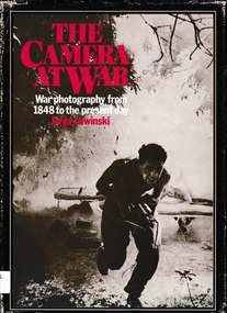
Book, W. H. Allen, The camera at war : a history of war photography from 1848 to the present day, 1978
The camera at war examines the nature of war photography and its relationship to society's view of warIndex, bib, ill, p.240.non-fictionThe camera at war examines the nature of war photography and its relationship to society's view of war"war photography - history, war photography -
 Monbulk RSL Sub Branch
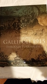
Book, Bahçeşehi̇r University Pres, Gallipoli 1915 : through Turkish eyes, 2012
A Turkish view of the Gallipoli campaignIndex, bib, ill, maps, p.485.non-fictionA Turkish view of the Gallipoli campaignworld war 1914-1918 - campaigns - gallipoli, military history - turkey -
 Bendigo Historical Society Inc.
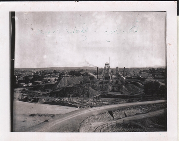
Photograph - BENDIGO GOLD FIELD: LANDSCAPE VIEW OF A MINE
Black and white photo (copy) . Image shows poppet head centre, poppet heads visible in far background. Two mine chimneys and large mullock heaps. Mine road way in front. Unnamed site but possibly New Chum mine in foreground. Hill visible in background. Taken looking towards easterly direction over Bendigo valley. -
 Monbulk RSL Sub Branch
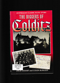
Book, Kangaroo Press, Diggers at Colditz, 1997
On June 23 1943 Lieutenant Jack Champ of the 2nd/6th Australian Infantry Battalion was marched into one of the most famous prisoner-of-war camps in Germany. Known then as Oflag IVC, it is now better know as Colditz. By the end of the war there were nineteen Australians in Colditz, and this is the first book to look at life there specifically from their point of view. It was a very special camp. It was designed to retain under escape-proof conditions, a select group of Allied prisoners who had already escaped from other camps and who had been recaptured whilst still in occupied territory. Having seen action in the Western Desert and in Greece, Jack Champ had been captured by the Germans in 1941. He was, however, a reluctant prisoner and took part in two escapes from different POW camps, one of which was a mass break-out of sixty officers through a tunnel that had taken weeks to make. Although the guards frequently outnumbered prisoners, there were more escapes from Colditz than from any other prison of comparable size during both World Wars. In this vivid book Jack Champ and Colin Burgess explain what it was like to be a prisoner in Nazi Germany. It is a curious blend of brutality and humanity, of routines and dreams, and occasional and dramatic excitement as men tried to turn those dreams into the reality of freedom.Index, ill, maps, p.224.non-fictionOn June 23 1943 Lieutenant Jack Champ of the 2nd/6th Australian Infantry Battalion was marched into one of the most famous prisoner-of-war camps in Germany. Known then as Oflag IVC, it is now better know as Colditz. By the end of the war there were nineteen Australians in Colditz, and this is the first book to look at life there specifically from their point of view. It was a very special camp. It was designed to retain under escape-proof conditions, a select group of Allied prisoners who had already escaped from other camps and who had been recaptured whilst still in occupied territory. Having seen action in the Western Desert and in Greece, Jack Champ had been captured by the Germans in 1941. He was, however, a reluctant prisoner and took part in two escapes from different POW camps, one of which was a mass break-out of sixty officers through a tunnel that had taken weeks to make. Although the guards frequently outnumbered prisoners, there were more escapes from Colditz than from any other prison of comparable size during both World Wars. In this vivid book Jack Champ and Colin Burgess explain what it was like to be a prisoner in Nazi Germany. It is a curious blend of brutality and humanity, of routines and dreams, and occasional and dramatic excitement as men tried to turn those dreams into the reality of freedom.world war 1939 – 1945 - prisons and prisoners – germany, world war 1939-1945 - personal narratives - australia -
 Monbulk RSL Sub Branch
Book, Tess Press, an imprint of Black Dog & Leventhal Publishers, Inc, World War II album : the complete chronicle of the world's greatest conflict, 2002
World War II Album presents a simultaneous documentary view of every theater of the war, from the steppes of Russia to the jungles of Malaysia and the Solomons; from the freezing cold of the northernmost fjords to the scorching sands of the Libyan desert; from the bunkers of the West Wall to the boundless oceans.Index, ill, maps, p.740.non-fictionWorld War II Album presents a simultaneous documentary view of every theater of the war, from the steppes of Russia to the jungles of Malaysia and the Solomons; from the freezing cold of the northernmost fjords to the scorching sands of the Libyan desert; from the bunkers of the West Wall to the boundless oceans.world war 1939-1945 - pictorial works, world war 1939-1945 - history -
 Puffing Billy Railway
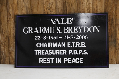
Locomotive Head Board - Funeral (Graeme S. Breydon), 2006
The funeral train Puffing Billy ran to farewell their Board chairman and Society Treasurer Graeme Breydon. G42 hauled a long train of passenger cars to Gembrook, and tucked in behind the loco was an NQR open wagon carrying Graeme's coffin. And in what is an old British tradition, the top layer of coal in the bunker was painted white (although the resulting smoke was still fairly black!). Two photos are attached. G42 in Belgrave yard, and a closer view of the NQR. The headboard read ---------------------------------- | VALE | | GRAEME S. BREYDON | | 22-8-1951 - 21-8-2006 | | CHAIRMAN ETRB | | TREASURER PBPS | | REST IN PEACE | Historic - Puffing Billy Railway Locomotive Head Board - used on the funeral train G42 that was ran by Puffing Billy to farewell their Board chairman and Society Treasurer Graeme Breydon.Locomotive Head Board - Funeral Head Board (Graeme S. Breydon) Black timber head board with white vinyl letters."Vale" Graeme S. Breydon 22-8/-1951 - 21-8-2006 Chairman E.T.R.B Treasurer P.B.P.S Rest in Peace graeme breydon, puffing billy, head board -
 Whitehorse Historical Society Inc.
Article, Valley view lost with ten day's notice, 2007
Residents in Irene Crescent Mitcham were angry that only 10 day's notice was given by Whitehorse Council prior to work starting on the implement shed at the Schwerkolt Cottage site.Residents in Irene Crescent Mitcham were angry that only 10 day's notice was given by Whitehorse Council prior to work starting on the implement shed at the Schwerkolt Cottage site. Resident Debbie Willenberg (photo) will have view restrictedResidents in Irene Crescent Mitcham were angry that only 10 day's notice was given by Whitehorse Council prior to work starting on the implement shed at the Schwerkolt Cottage site.schwerkolt cottage & museum complex, willenberg, debbie, irene crescent, mitcham, wilkinson, terry, city of whitehorse -
Lakes Entrance Regional Historical Society (operating as Lakes Entrance History Centre & Museum)
Photograph, 1926 c
5003.2 Also a black and white photograph of distant view of Buchan Valley 05003.2 7 x 11.5 cmBlack and white photograph of a roadway scene showing early car and fence with water along road near Glenmaggie Victoriaroads and streets -
 Mt Dandenong & District Historical Society Inc.
Photograph, Kalorama Valley c1913
The photograph shows the view from Crook's allotment #24. 'Kia-Ora' guesthouse is in the foreground with J.W. Richardson's home 'Mt Calvin' above it. Isaac Jeeves' pioneer complex is on the right. F.M. Child's complex is above it. The guest house 'Glenrivers' is at the far end of the clearing. The photograph was taken c1913.Black and white photograph (copy of an original) looking across the Kalorama Valley with a view of vegetation and homesteads. kalorama, kia-ora guest house, isaac jeeves, f. m. child, child, jeeves, john willie richardson, mt calvin, glenrivers -
 Mt Dandenong & District Historical Society Inc.
Photograph, George Barber's Home Forest Edge after 1912 Looking South West, c1912
George Barber built a homestead later named Forest Edge on Barber's Road and lived there with his wife Sarah Ann (nee Richardson).Black and white photograph showing the side view of a house and three outbuildings. Reverse of photograph has handwritten description by John Lundy-Clarke.George Barber's home on bend of Barber's Road on Lot 25, Village Settlement. Showing passionfruit plantation. Buggy shed top right. Hay shed lower right. Stables, cart shed and men's quarters lower left about 1912. Photo copied by JLC in 1973.forest edge, george barber, sarah ann barber, kalorama, barber's road -
 Mt Dandenong & District Historical Society Inc.
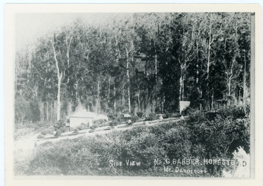
Photograph, Side View Mr G. Barber Homestead Mt Dandenong, c1905
Built in 1898 by early settler George Barber the property is still in existence today. It was the home of George, wife Sarah Ann and daughter Ethel.Black and white photograph showing te side view of George Barber's home, later named Forest Edge. c1905. Reverse of photograph has handwritten description by John Lundy-Clarke.Barber's home on Olinda Creek. Lot 25 Sect 1 Village Settlement. Home of George Barber and wife Sarah Ann (nee Richardson). Daughter Ethel.Was bought by Munnerley later Sangster and Kinnear. Later known as Forest Edge. Buggy and wagon shed on right. Photo copied 1973 by JLC. -
 Mt Dandenong & District Historical Society Inc.
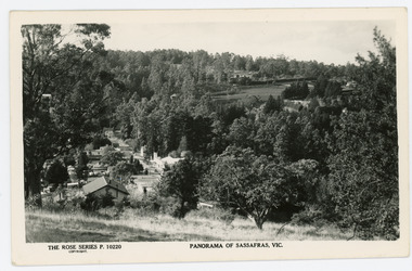
Photograph, Panorama of Sassafras, Vic, c1950
Panorama of Sassafras in the 1950s taken from Wallaby Avenue looking down onto the Sassafras Cabaret building. Rostrevor can be seen at centre top.Black and white Rose Series postcard P. 10220 showing a view from high down the Main Street of Sassafras looking north towards Olinda.On reverse POST CARD. A Real Photograph. Produced in Australia.rose series, postcard, sassafras, cabaret, wallaby avenue, rostrevor -
 Mt Dandenong & District Historical Society Inc.
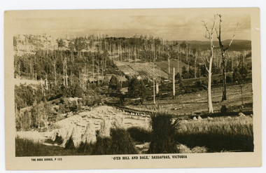
Photograph, 'O'er Hill and Dale,' Sassafras. Victoria, c1920
View of Sassafras showing many dead trees c1920s.Sepia coloured Rose Series postcard P. 153 looking down across Sassafras.On reverse REAL PHOTO POST CARD. THE "ROSE' SERIES DELUXE. PRODUCED IN AUSTRALIA. PUBLISHED BY 'THE ROSE STENOGRAPHS" Armadale. Victoriasassafras -
 Mt Dandenong & District Historical Society Inc.
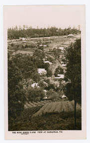
Photograph, View at Sassafras, Vic, c1930
View down the Main Street of Sassafras looking south with the Mechanics Institute in the centre of the picture. The raspberry patch in the foreground belonged to Woniger Hansen who built Mountain Rest (Rostrevor). The land was subdivided after his death in 1923. The raspberry patch is in the area of the current Mason Grove.Black and white Rose Series postcard P. 4765 looking south down the Main Street of Sassafras with buildings either side and berry patches in the foreground.On reverse POST CARD. THE "ROSE' SERIES DELUXE. A REAL PHOTOGRAPH PRODUCED IN AUSTRALIA. PUBLISHED BY 'THE ROSE STENOGRAPHS" Armadale. Victoria sassafras, rose series, rostrevor, woniger hansen, hansen, mechanics' institute, raspberry, raspberry crop, mountain rest, mason grove -
 Mt Dandenong & District Historical Society Inc.
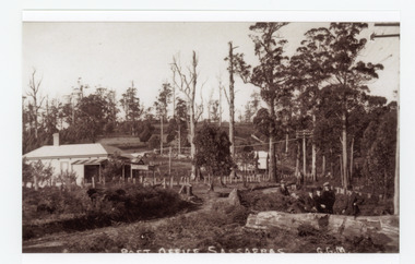
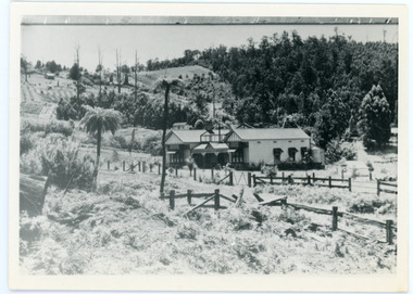
Photograph, Post Office Sassafras, c1930s
View of Hinkley Guest House on the left where the Post Office occupied a room in the front corner. The post operated from 1912 until 1937 when the building burned down. The Post Office then moved up to one of the Cadby Cottages near Rostrevor. The empty block of land next to Hinkley was where Sassafras School was built a few years later.Black and white copy of GGM photograph showing a group of five well dressed men in the foregroundbehind a large log with the Post Office and Telegraph office on the left.On front - POST OFFICE SASSAFRAS G.G.M.sassafras, post office, post office, hinkley, cadby cottages, sassafras school, rostrevor -
 Mt Dandenong & District Historical Society Inc.
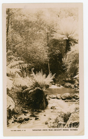
Photograph, Sassafras Creek Near Crescent Bridge. Victoria
Rose Series post card # P. 90. Sassafras Creek near The Crescent Bridge. View of water and ferns. Post 1920.Rose Series sepia coloured post card showing a small creek running through the centre of the photo edged by rocks and tree ferns.On front: The Rose Series, P. 90. SASSAFRAS CREEK NEAR CRESCENT BRIDGE. VICTORIA.sassafras creek, crescent bridge, creek, bridge, tree ferns, rose series, post card -
 Mt Dandenong & District Historical Society Inc.
Photograph, Crescent Bridge Sassafras
The Crescent Bridge crossing Sassafras Creek on 'The Crescent' at Sassafras. View of water and ferns. c1912Black and white copy of a post card a bridge with a bush and tree fern background.On front: Crescent Bridge Sassafrassassafras, crescent bridge, the crescent, tree ferns, bridge -
 Mt Dandenong & District Historical Society Inc.
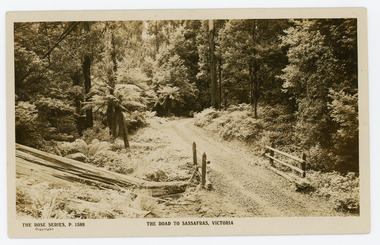
Photograph, The Road to Sassafras. Victoria
Rose Series postcard # P. 1588 showing a view of the road to Sassafras pre WW1.Sepia Coloured Rose Series post card P.1588 showing a stretch of unmade road passing over a simple bridge on the road to sassafras.On Front: THE ROSE SERIES, P. 1588 THE ROAD TO SASSAFRAS, VICTORIArose series, postcard, sassafras, road -
 Mt Dandenong & District Historical Society Inc.
Photograph, View Up Valley At Kalorama
John Lundy-Clarke grew up in the Kalorama/Mt Dandenong area and later in life (1972-74) began to write a comprehensive history of the area working from an original settlement map in an effort to cover all areas. The building in the centre of the photograph is 'Kia-Ora' guest house. Situated on Barber’s Road, ‘Kia-Ora’ was built in 1912 by George Barber. It was later leased by a Mrs Pemberthy. “Kia-Ora’ was one of four places connected when the telephone was brought into the district in 1912. The other places were ‘Mountjoy’, ‘Cherry Farm’ and ‘Callum House’. ‘Kia-Ora’ was burnt down in 1924. Black and White copy of section of a Rose Series postcard. Shows view up the valley at Kalorama with a decorative building centre middle of photograph. Handwritten description by John Lundy-Clarke on reverse.View up valley at Kalorama from near junction of Barbers and Doughty’s Rds. “Kia Ora” guest house in centre. Paynter’s “Iona” top left with “Kalorama” to its right. About 1912. Rose Series copied by JLC 1973.kalorama, kalorama valley, john lundy-clarke, barbers road, george barber, kia-ora, guest house, iona -
 Mt Dandenong & District Historical Society Inc.
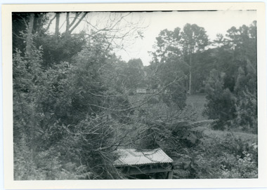
Photograph, View from George Barber's Home To His Stables
John Lundy-Clarke grew up in the Kalorama/Mt Dandenong area and later in life (1972-74) began to write a comprehensive history of the area working from an original settlement map in an effort to cover all areas. This photograph was taken by John Lundy-Clarke in 1973 to show changes to the environment sine 1905.Black and white photograph with tangled bush and small shed in foreground looking towards a cleared area. Handwritten description on reverse written by John Lundy-ClarkeView from Barbers drive to his stables close to where 1905 picture was taken. Stables in foreground. Looking towards Gap. Taken JLC November 1973.barbers road, john lundy-clarke, kalorama -
 Mt Dandenong & District Historical Society Inc.
Photograph, View of the Kalorama Valley c1905
John Lundy-Clarke grew up in the Kalorama/Mt Dandenong area and later in life (1972-74) began to write a comprehensive history of the area working from an original settlement map in an effort to cover all areas. This photograph c1905 is looking up from George Barber's house 'Forest Edge' on Barbers Road. 'Forest Edge' was built c1898 and was the home of George Barber and his wife Sarah Ann (nee Richardson). The buildings in the foreground are the stables and hayshed.Black and white photograph showing two small buildings in the foreground with cleared hills behind. Handwritten decription on back by John Lundy-ClarkeA 1905 view of the Kalorama Valley towards the Gap. Barbers stables in foreground with hayshed on left. Tait’s house in centre of picture with Logans in the same fold above the hayshed. “Kalorama” is centre of Gap with Paynter’s “Iona” on its left with stables to its left. It was from one of these trees on the top left that the runaway log was cut that leaped over Barbers Road (at the top edge of the cleared land) then over Logan’s house in one bound in 1930.george barber, sarah ann barber, john lundy-clarke, forest edge -
 Mt Dandenong & District Historical Society Inc.
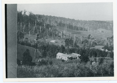
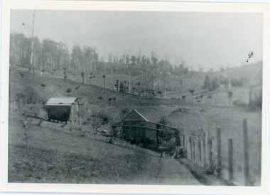
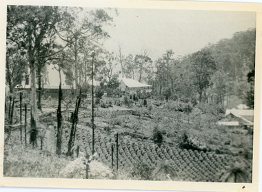
Photograph, View Over Logan's From Barber's Road
Robert Logan selected Lot 28 of the Village Settlement in 1896 and lived there until his death in 1936. Historian John Lundy-Clarke tells how Logan planted his land with plums, peaches and apples and also grew raspberries, beans, cabbages and lettuces. He also planted a small patch of oats that he harvested to feed his horse. This photograph was taken c1920 and shows the view over Logan's property of Harmony Vale, taken from Barber's Road.Black and white photograph showing lines of crops and orchard trees with rooftops in foreground and larger trees and cleared areas in background.robert logan, logan, orchard, crops, raspberries, harmony vale, barbers road -
 Mt Dandenong & District Historical Society Inc.
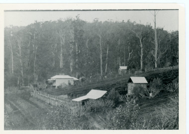
Photograph, View Over Roof of "Kalorama"
Taken in 1908, this photograph, though rather blurry, gives an indication of the location of the early settler properties in the valley in relation to one another. European trees have been planted at 'Kalorama' , the first home of Ellis Jeeves. John Lundy-Clarke grew up in the Kalorama/Mt Dandenong area and later in life (1972-74) began to write a comprehensive history of the area working from an original settlement map in an effort to cover all areas.Black and white photograph looking across hillside with large trees and rooftops visible. Handwritten description on reverse by John Lundy-Clarke.1908 View over roof of “Kalorama” towards the Falls. Paynter’s house on LOT 29 in low centre (now “Yosemite”). Pimms house on LOT 19 above Paynters and beyond scrub. Logan’s house faint above left of “Kalorama”. Dunbar’s LOT 20 beyond Pimm’s orchard. Gum trees on right were on Price’s LOT 19 now Tosari Rd area. It was one of these that figured in the episode of the runaway log in 1930. It leaped in one bound over Barbers Road at bottom of scrub in centre of picture then over Logan’s house.kalorama, ellis jeeves, jeeves -
 Mt Dandenong & District Historical Society Inc.
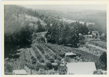
Photograph, View of Kalorama Gap 1905
Kalorama Gap viewed from the South West in 1908. Ellis Jeeves' 'Mountjoy' is in the centre with the stables to the left. The raspberry patch belongs to Harry Walker and the building centre right to Edward Joseph Price. John Lundy-Clarke grew up in the Kalorama/Mt Dandenong area and later in life (1972-74) began to write a comprehensive history of the area working from an original settlement map in an effort to cover all areas.Black and white photograph showing an extensive raspberry crop in the foreground with a house and outbuilding in the centre and another dwelling centre right. Handwritten description on reverse by John Lundy-Clarke. 1908 view of Kalorama Gap taken from corner of Village Settlement LOTS 2 and 3 on Ridge (then Main Road) which crosses centre of picture with Walker’s driveway dropping left. Walker’s raspberry patch in foreground. “Mountjoy” in centre of picture with coaching stables on left. Price’s house and shop on right showing large cross room used by the Village Settlers for dancing. Mrs Hand’s “Beulah Tearooms” later Mt Dandenong North Post Office is above Price’s roof.kalorama gap, kalorama, harry walker, walker, edward joseph price, raspberry, mountjoy -
 Mt Dandenong & District Historical Society Inc.
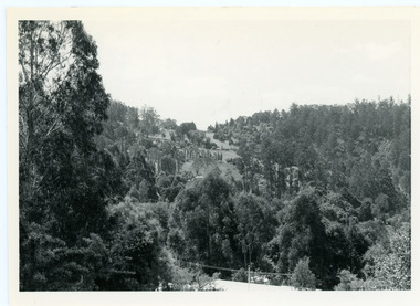
Photograph, View From Doughty's Road 1974
John Lundy-Clarke grew up in the Kalorama/Mt Dandenong area and later in life (1972-74) began to write a comprehensive history of the area working from an original settlement map in an effort to cover all areas. This photograph shows approximately the same area as photograph number KAL0193 but is taken 60 years later. The trees have grown much taller and the buildings changed. On the site of the Paynter house 'Iona' there is now the 'Yosemite' (Villa Toscana) accommodation. The pavilion in the centre of the photo is the site of 'Kalorama', home of early pioneer Isaac Jeeves. The photograph is taken looking up towards The Gap (FiveWays).Black and white photograph showing a forested area with clear sites. Roofs of buildings can be clearly seen. Handwritten inscription on reverse by John Lundy-ClarkeView from near Doughty’s Rd looking north up valley to Kalorama Gap in Jan 1973. Tiny roof in centre is pavilion on site of “Kalorama”. Long roof to its left is Yosemite Motel on site of “Iona”.paynter, kalorama, iona, yosemite, villa toscana, five ways, the gap -
 Mt Dandenong & District Historical Society Inc.
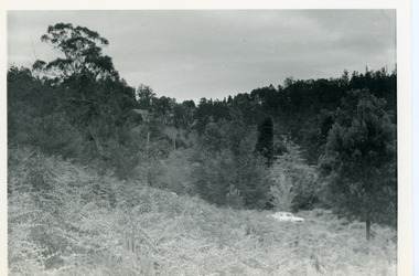
Photograph, View Up Valley Towards Kalorama Gap 1973
John Lundy-Clarke grew up in the Kalorama/Mt Dandenong area and later in life (1972-74) began to write a comprehensive history of the area working from an original settlement map in an effort to cover all areas. This photograph would have been taken to show the changes in the area over the years. Kalorama Gap is now called Five Ways. 'Kia-Ora ' was a guest house built by George Barber. It is no longer standing.Black and white photograph showing a bush scene with a white car visible on the right. Handwritten inscription on reverse by John Lundy-Clarke1973 View up Valley towards Kalorama Gap from what was Crooks LOT 24. White car is on Barbers Road and site of “Kia Ora” is to right of it.kalorama, kalorama gap, five ways, barbers road, george barber, kia-ora -
 Mt Dandenong & District Historical Society Inc.
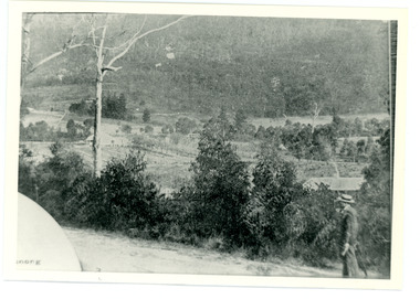
Photograph
This photograph was taken c1908 and shows the view from Mt Dandenong Road, Montrose about 275 metres north of Sheffield Road.Black and white photograph showing a man in a white hat walking up a dirt road wth bush a nd a house roof to his right.mt dandenong, montrose, sheffield road -
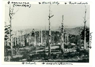 Mt Dandenong & District Historical Society Inc.
Photograph
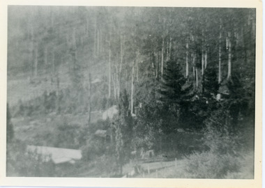
Iconic photograph taken by Edgar Dower on Ridge Road in 1913 from an area known as Point Clear that shows the buildings of early Mt Dandenong before the CRB road went through in the 1920s.Black and white photograph with tall, dead trees in foreground and a view of hills in the distance. Buildings can be seen across the centre of the photograph. There are handwritten annotations around the border with arrows referring to areas in the photograph. Reverse of photograph has handwritten description by John Lundy-Clarke.Front from top left: Namoora (Lumeah), Dower's Shop, First school, Talent's, Langford's house, School. Reverse: 1913 view from O'Halloran's LOT 4, Section 3 on Ridge Road. Showing Lumeah (Namoora) Farndons Road (fence) School, Lowes House?, Falls Road Shop (Dowers) Langford's Falls Road (LOT 9, Section 1) Shed on Colomb's LOT 19, Sect 2 Colomb's House (Fergusons) First school Campbell's Blythes Road Lil Badenhop's P.O. In middle distance - Talent's homestead and sheds.point clear, namoora, lumeah, langford, dower, talent, colomb, ferguson, campbell, farndons road, mt dandenong school -
 Mt Dandenong & District Historical Society Inc.
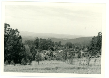
Photograph
In 1913 Edgar Dower took a photograph from this spot on Ridge Road that became known as Point Clear showing the Mt Dandenong township behind a stand of tall, dead trees. John Lundy-Clarke took this photograph from a similar spot at the Mt Dandenong Arboretum in 1975.Black and white photograph showing a cleared area in the foreground with young tress in the centre and hills in the distance. Several rooftops can be seen mid photo on the right. Reverse of photograph has handwritten description by John Lundy-Clarke.1975 View from the Arboretum over Mt D'nong township at the spot where Edgar Dower took the 1913 photo. The Falls gully is in the middle distance. Peter Damman's fence running downhill right foreground.edgar dower, point clear, mt dandenong, john lundy-clarke, peter damman, arboretum -
 Mt Dandenong & District Historical Society Inc.
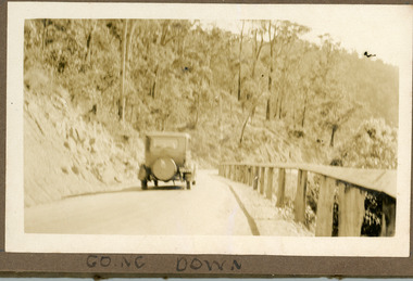
Photograph
The photograph is a pair to a similar photograph taken from the front view. The car is travelling down the CRB or Main Road at Kalorama c1930. Now named the Mt Dandenong Tourist Road. The photograph is glued in the Ivy Child Album. Ivy May Child (1910 – 1989) was the daughter of Arthur Edward (Ted) Child (1878 – 1964) and Ethel May Madden (1888 – 1970). Ted Child was the son of Matthew Francis Child (1839 – 1933) and Martha Jeeves (1857 – 1926). He was the grandson of one of the early pioneers Francis Child. Ivy grew up on the family property on Childs Road and took many photographs. Most of these are glued into her photo album. The album covered the years from c1927 – 1932. Ivy married Henry William Burgess (1906 – 1968) in 1944. The photographs remain in their original state in the album with individual copies made. Sepia coloured photograph showing an old car travelling down a road bordered by a rail fence.Written below the photograph in album: Going Downcar, automobile, ivy child, crb road, main road, mt dandenong tourist road