Showing 1479 items
matching c hill
-
 Flagstaff Hill Maritime Museum and Village
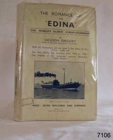
Book, The Romance of The Edina, 1935
This book is titled "The Romance of the "Edina" and was written by author C. Dickson Gregory (Charles Dickson Gregory) in 1935. The author has also written, "Australian Steamships Past and Present". This book also contains (1) The Port Phillip Bay Steamers from 1850 to 1935 (2) The history of the celebrated auxiliary steamship "Great Britain." ABOUT THE S S EDINA The three-masted iron screw steamer SS Edina was built in Glasgow, Scotland, in 1854 by Barclay and Curle. She was adorned with the figurehead of ‘fair maid of Judea’. The many years of service made SS Edina famous world-wide as the longest-serving screw steamer. (The term screw steamer comes from being driven by a single propeller, sometimes called a screw, driven by a steam engine.) SS Edina’s interesting history includes English Chanel runs, serving in the Crimean Ware carrying ammunition, horses and stores to the Black Sea, and further service in the American Civil War and later, serving in the western district of Victoria as well as in Queensland and carried gold, currency and gold prospectors Australia to New Zealand. SS Edina had the privilege of being an escort vessel to H.R.H. the Duke of Edinburgh during his visit to Australia in 1867. In March 1863 SS Edina arrived in Port Phillip Bay, Melbourne and was bought by Stephen Henty, of Portland fame, to work the cargo and passenger run from Melbourne – Warrnambool – Port Fairy - Portland. After a short time of working the run from Australia to New Zealand, with passengers and cargo that included gold and currency, she returned to her Melbourne - Warrnambool – Port Fairy run, with cargo including bales of wool produced in the western district of Victoria. The Warrnambool Steam Packet Company purchased SS Edina in 1867; she was now commanded by Captain John Thompson and Chief Engineer John Davies. She survived several mishaps at sea, had a complete service and overhaul and several changes of commanders. In 1870 SS Edina was in Lady Bay, Warrnambool, when a gale sprung up and caused a collision with the iron screw steamer SS Dandenong. SS Edina’s figurehead was broken into pieces and it was not ever replaced. SS Edina was re-fitted in 1870 than was used as a coastal trader in Queensland for a period. She was then brought to Melbourne to carry cargo and passengers between Melbourne and Geelong and performed this service 1880-1938. During this time (1917) she was again refitted with a new mast, funnel, bridge and promenade deck, altering her appearance. In 1938, after more collisions, SS Edina was taken out of service. However, she was later renamed Dinah and used as a ‘lighter’ (a vessel without engine or superstructure) to be towed and carry wool and general cargo between Melbourne and Geelong. In 1957, after 104 years, the SS Edina was broken up at Footscray, Melbourne. Remains of SS Edina’s hull can be found in the Maribyrnong River, Port Phillip Bay. [Reference: A Brief Review of Steam Navigation in Victoria; C Dickson Gregory; Centenary Maritime Exhibition catalogue, 1934; published by Shiplovers' Society of Victoria Dandenong, Passengers in History, http://passengersinhistory.sa.gov.au/node/924034 Edina, Victorian Heritage Database VHR S199 http://vhd.heritage.vic.gov.au/shipwrecks/heritage/199 SS Edina, Coastal Trader and Passenger Ship 1853-1938, Museum Victoria Collections, https://collections.museumvictoria.com.au/articles/6227 SS ‘Edina’ – the Longest Serving Screw Steamer in the World, POI Australia, https://poi-australia.com.au/ss-edina-the-longest-serving-steamer-in-the-world/ ]This book about the SS Edina is significant for its association with the screw steamer SS Edina. The SS Edina is heritage listed on the Victorian Heritage Database VHR S199. She had endeared herself to the people of Port Phillip Bay as a passenger ferry, part of their history and culture. She played a significant role in the Crimean War, the American Civil War and the gold rush in New Zealand. She also served western Victoria for many years in her cargo and passenger runs. The SS Edina is famous for being the longest serving screw steamer in the world. After spending her first nine years overseas she arrived in Melbourne and her work included running the essential service of transporting cargo and passengers between Melbourne and the western Victoria ports of Warrnambool, Port Fairy and Portland. The SS Edina was purchased in the late 1860’s by local Warrnambool business, the Warrnambool Steam Packet Co. and continued trading from there as part of the local business community. The SS Edina’s original ‘fair maid of Judea’ figurehead was broken to pieces in a collision with another vessel (the SS Dandenong) in a gale off Warrnambool, Victoria, in 1870.The Romance of The "Edina"; the World's oldest screw-steamship, by C Dickson Gregory (Charles Dickson Gregory). Hard cover book with black print on cream coloured jacket, covered in clear plastic. Front cover has a black and white photograph of the steamship and is titled " "Edina" as she is today." With chapters on the Auxiliary Steamship "Great Britain" and the Port Phillip Bay Steamers Past and Present. Published in Melbourne by Robertson & Mullens Ltd. Opposite fly page is a picture from a painting by C. Dickson Gregory titled "Edina in the "roaring forties" in Feburary 1863" The book contains 43 illustrations and one plate in full colour showing the Edina in full sail. The price is printed on the jacket "PRICE: SEVEN SHILLINGS AND SIXPENCE"warrnambool, shipwrecked coast, flagstaff hill, flagstaff hill maritime museum, maritime museum, shipwreck coast, flagstaff hill maritime village, shipwrecked artefact, barclay & curle, figurehead 'fair maid of judea', centenary maritime exhibition 1934, a brief review of steam navigation in victoria, pleasure steamer edina, trade and travel late 19th and early 20th century, trade melbourne to geelong, screw steamer edina, coastal trader edina, lighter dinah, cargo carrying for cremean war, cargo carrying for american civil war, passenger and trade in western district of victoria, export gold and currency and gold diggers to new zealand, export vessel to h r h the duke of edinburgh, melbourne - warrnambool - port fairy - portland cargo run, warrnambool steam packet company, stephen henty, captain john thompson, chief engineer john davies, lady bay warrnambool, lighter edina, shipping victoria, port phillip bay steamers, steamship great britain, edina, vhr s199 victorian heritage database, book, the romance of the edina, c dickson gregory, robertson & mullens melbourne -
 Ringwood and District Historical Society
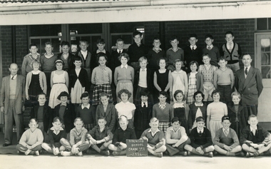
Photographs, L.E.Reynolds, Photographer Surrey Hills E 10, Set of 4 Ringwood S.S.2994 photos from 1951 and 1954-1956 with covering letter, 1951-1956
Photos belonging to Phyllis Rudolph (nee Horgan) who attended Ringwood S.S.2997 between 1951 and 1956. Given to the Historical Society by her uncle Stanley Hendrickson from his late niece's photo collection.4 Band W photos of Ringwood S.S. 2994 classes 1b 1951, IV c 1954, V a1955 and VI d 1956 Plus covering letter +Additional Keywords: Rudolph , Phyllis (nee Horgan) / Reynolds, L. E. / Hendrickson, SPhyllis Horgan's position in each of the photos -
 Ringwood and District Historical Society
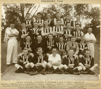
Photograph, Ringwood Football Club 1948 Firsts Premiership team, 1948
Herbie MATTHEWS (the Captain/Coach) previously played with South Melbourne in the then Victorian Football League.Photo of Ringwood Football Club 1948 Firsts Premiership team. Ringwood Football Club Premiership 1948. Back row - G Mahon, J Maidment, M Westmore, R East, F Barro, C Fitzgerald. Third row - J Prouse (trainer), M Maidment, G Hinds, J Morgan, H Morgan, A Tasker, J Westmore, Leo Pratt (trainer). Second row - W Connell, K Pratt (President), S Beal, H Matthews (Captain and coach), J Lindsay (Secretary), V Morphett. front row - K Hare, I Binns, M Donaldson (Boundary Umpire), J Burgess, T Pratt. On the back "Geoffrey Baker Studios, 620 Burke Rd, Camberwell, WF8070, 961 Whitehorse Road, Box Hill, WX3645, 28 Pitt St, Ringwood, WU8201. -
 Ringwood and District Historical Society
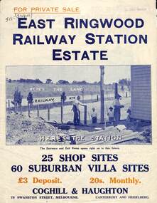
Flyer, Land Sale Brochure, East Ringwood Station Estate - c.1925
Multi-fold double sided sheet with yellow and blue print and blue monotone photographs advertising private sale of retail and residential sites. Brochure includes price list, and details of subdivision features and local facilities, with photographs.Subdivision includes Railway Avenue, Dublin Road, Lawrence Grove, Stanley Avenue. Agents - Coghill & Haughton, 79 Swanston Street, Melbourne, Phone Central 2793. Photographs include construction of East Ringwood Railway Station, "The Dive" where aquatic sports are held, Old East Ringwood Township, Davey's Hill. -
 Ringwood and District Historical Society
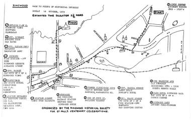
Pamphlet, Ringwood Walk - Points of Historical Interest, 1979
Sketch of walking route for 17 historical points of interest organised by the Ringwood Historical Society for St. Paul's Church Centenary Celebrations - 14 October 1979, estimated duration 2-1/4hours.1 - Start 2 - Cnr Braeside Avenue, old township, brickworks 1881-1916, Guests, Herrys, Hills 3 - Club Hotel, Ringwood Hall, 1st site of C of E church corner 4 - Ringwood Lake, Anthony Ford - pioneer 5 - Opposite Bardia Street, Sandy Gully, Duncan's Hotel 6 - Opposite Pratt Street, 2nd site of C of E, 2nd fire station, Bentleys, old shopping centre 7 - Warrandyte Road, Former Clocktower site, Pratts butcher shop, Bamfords 8 - End of Pitt Street, building viaduct 9 - Bedford Road, Webdales, old crossing, railway station 10 - Station Street, views over railways 11 - Station entrance, old shopping centre, 2nd Postoffice, 2nd blacksmiths, Mechanics Institute, Town Hall 12 - Clocktower, 3rd State School, coolstores, 3rd Postoffice, market, Kenworthys 13 - Opposite market, 3rd site of C of E, Ringwood views 14 - Adelaide Street, Dickens, 1st fire station, Ringwood Reserve 15 - Opposite squash courts, Matlocks, Salvation Army 16 - Opposite library, bowling club, old baths 17 - Outside C of E, Ringwood views, Brittens, Glamorgan -
 Ringwood and District Historical Society
Packet, Gwen Reed nee Woodford family memorabilia c.1880s-c.1980s, Circa 1880s to c1980s
Collection of various family and personal documents, photographs, and early 1900s greeting cards. Papers of Gwen Reed from Edith Graham of Ware Cres, Ringwood East. (Provided by Nicki Shea, Granddaughter of Stan & Jo Bridgman of Eastwood Cycles) Contents: Hand-written notes – Woodford Family Tree, by Gwen Reed Autograph book with entries "To Gwen" Bookmark - with name "Lorrie B" Christmas card to May with love from George 1906 Christmas card from May to George 1906 Christmas card from Edie to Gwen (Cousin Ede) Christmas card from Dot to Gwen 1925 (from Dot Grundy, dc'd) Christmas card from Ollie S to Gwen 1924 Happy New Year card to Gwen from Grandma (Woodford) Christmas card from Mum & Ethel to Gwen 1926 Christmas card to Gwen from Emily (Gawith, Jeparit East) Christmas card from Olive to Gwen 1919 (Olive Janetski, Jeparit East) Christmas card from Hilda (Obst) to Gwen 1929 Postcard to Miss G Woodford "Bygalorie Park" Tullibigeal PO NSW (To Gwen from Effie - Effie Robson, Jeparit East) Christmas card to Gwennie from C. S. Graham 1915 (School teacher) Christmas card from Mum to May & George Christmas postcard from Grandfather to Gwenny Christmas card to Dear Daddie from Gwen Christmas card from May with love to George Christmas card from Nellie Parker (Nell Rodgers - Albury) to Gwen 1924 Greeting card from Hilda to Gwen 1919 (Hilda Obst Jeparit East) Christmas card from Ethel to Gwen 1927 Christmas card from Anne (MCGrath) to Gwen Christmas card from S. Hoober(?) (School teacher, Bygalorie) to Mr & Mrs Woodford, Gwen & Ollie) 1924 Christmas card from May and George to Mum and Dad 1925 Christmas card to Gwen Syd & Family from May Dad & Kiddies (Stepmother) Christmas card from George to May 1907 Postcard (signed Dulcie) to Mrs G. Reed, 9 Laurence Grove, East Ringwood Vic 3055 postmarked 1993 Envelope (only) addressed to Mrs. G. Reed, 9 Laurence Grove, Ringwood East Vic. 3135 Birth Certificate District of Balmoral, Victoria – Sonia Woodford b.1856 (Issued 1987) Death Certificate District of Stawell, Vic – Archibald Brown d.1914 Marriage Certificate District of Hamilton, Vic – John Brown & Margaret Dale m.1895 Coroner’s Post-Mortem report – Edward John Reed d.1981 Family Data Tree (Family Tree) William Walker/Elizabeth Silk, Hamilton Vic & children b.1842-1862 Newspaper clipping – May & Archibald Brown drowned at North Hamilton, 1887 Pictorial Souvenir – Selected Views of Mount Gambier to Miss L. Boyce, postmarked 1959 Hand-written poems/song lyrics by Gwen Reed (4 pages) Newspaper extract - Weekly Times Magazine Section “At Hamilton”, 1937 Photograph – “My mother standing with Foster parents” Photograph of Gracie (?) Grandma (?) Murray (?) Photograph of costumed performers Photograph of child Photograph of lady at John Mansell dispensary (Chemist at Forest Hill Vic?) Postcard photograph – Gwen & Ethel Woodford Photograph of grave – Victoria May Woodford (died 1957 aged 56 years) Photograph of grave – William Woodford and Sarah Woodford Photograph of un-named male Photograph of baby on chair Photograph – “Myself. Hope you like it May" Photograph (colour) – un-named group on train at Currumbin Qld Photograph – 2 un-named girls Autographs include Arthur Young Rosie Sturgess Joff Ellen Carlu Carter Toni Lamond Dick Curtis Billy Daniels Margaret Whiting Horrie Dargie Duo Moreno Therese Talbert Richard Gray Three Apollos Robert Leeman -
 Flagstaff Hill Maritime Museum and Village
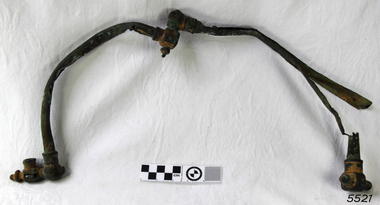
Functional object - Gas Fitting, c. 1873
This gas fitting was recovered from the wreck of the Loch Ard circa 1970, at the time of the discovery of the wreck. HISTORY OF THE LOCH ARD: - The LOCH ARD belonged to the famous Loch Line which sailed many ships from England to Australia. Built in Glasgow by Barclay, Curdle and Co. in 1873, the LOCH ARD was a three-masted square rigged iron sailing ship. The ship measured 262ft 7" (79.87m) in length, 38ft (11.58m) in width, 23ft (7m) in depth and had a gross tonnage of 1693 tons. The LOCH ARD's main mast measured a massive 150ft (45.7m) in height. LOCH ARD made three trips to Australia and one trip to Calcutta before its final voyage. LOCH ARD left England on March 2, 1878, under the command of Captain Gibbs, a newly married, 29 year old. She was bound for Melbourne with a crew of 37, plus 17 passengers and a load of cargo. The general cargo reflected the affluence of Melbourne at the time. On board were straw hats, umbrella, perfumes, clay pipes, pianos, clocks, confectionary, linen and candles, as well as a heavier load of railway irons, cement, lead and copper. There were items included that intended for display in the Melbourne International Exhibition in 1880. The voyage to Port Phillip was long but uneventful. At 3am on June 1, 1878, Captain Gibbs was expecting to see land and the passengers were becoming excited as they prepared to view their new homeland in the early morning. But LOCH ARD was running into a fog which greatly reduced visibility. Captain Gibbs was becoming anxious as there was no sign of land or the Cape Otway lighthouse. At 4am the fog lifted. A man aloft announced that he could see breakers. The sheer cliffs of Victoria's west coast came into view, and Captain Gibbs realised that the ship was much closer to them than expected. He ordered as much sail to be set as time would permit and then attempted to steer the vessel out to sea. On coming head on into the wind, the ship lost momentum, the sails fell limp and LOCH ARD's bow swung back. Gibbs then ordered the anchors to be released in an attempt to hold its position. The anchors sank some 50 fathoms - but did not hold. By this time LOCH ARD was among the breakers and the tall cliffs of Mutton Bird Island rose behind the ship. Just half a mile from the coast, the ship's bow was suddenly pulled around by the anchor. The captain tried to tack out to sea, but the ship struck a reef at the base of Mutton Bird Island, near Port Campbell. Waves broke over the ship and the top deck was loosened from the hull. The masts and rigging came crashing down knocking passengers and crew overboard. When a lifeboat was finally launched, it crashed into the side of LOCH ARD and capsized. Tom Pearce, who had launched the boat, managed to cling to its overturned hull and shelter beneath it. He drifted out to sea and then on the flood tide came into what is now known as LOCH ARD Gorge. He swam to shore, bruised and dazed, and found a cave in which to shelter. Some of the crew stayed below deck to shelter from the falling rigging but drowned when the ship slipped off the reef into deeper water. Eva Carmichael had raced onto deck to find out what was happening only to be confronted by towering cliffs looming above the stricken ship. In all the chaos, Captain Gibbs grabbed Eva and said, "If you are saved Eva, let my dear wife know that I died like a sailor". That was the last Eva Carmichael saw of the captain. She was swept off the ship by a huge wave. Eva saw Tom Pearce on a small rocky beach and yelled to attract his attention. He dived in and swam to the exhausted woman and dragged her to shore. He took her to the cave and broke open case of brandy which had washed up on the beach. He opened a bottle to revive the unconscious woman. A few hours later Tom scaled a cliff in search of help. He followed hoof prints and came by chance upon two men from nearby Glenample Station three and a half miles away. In a state of exhaustion, he told the men of the tragedy. Tom returned to the gorge while the two men rode back to the station to get help. By the time they reached LOCH ARD Gorge, it was cold and dark. The two shipwreck survivors were taken to Glenample Station to recover. Eva stayed at the station for six weeks before returning to Ireland, this time by steamship. In Melbourne, Tom Pearce received a hero's welcome. He was presented with the first gold medal of the Royal Humane Society of Victoria and a £1000 cheque from the Victorian Government. Concerts were performed to honour the young man's bravery and to raise money for those who lost family in the LOCH ARD disaster. Of the 54 crew members and passengers on board, only two survived: the apprentice, Tom Pearce and the young woman passenger, Eva Carmichael, who lost all of her family in the tragedy. Ten days after the LOCH ARD tragedy, salvage rights to the wreck were sold at auction for £2,120. Cargo valued at £3,000 was salvaged and placed on the beach, but most washed back into the sea when another storm developed. The wreck of LOCH ARD still lies at the base of Mutton Bird Island. Much of the cargo has now been salvaged and some was washed up into what is now known as LOCH ARD Gorge. Cargo and artefacts have also been illegally salvaged over many years before protective legislation was introduced. One of the most unlikely pieces of cargo to have survived the shipwreck was a Minton porcelain peacock - one of only nine in the world. The peacock was destined for the Melbourne International Exhibition in 1880. It had been well packed, which gave it adequate protection during the violent storm. Today, the Minton peacock can be seen at the Flagstaff Hill Maritime Museum in Warrnambool. From Australia's most dramatic shipwreck it has now become Australia's most valuable shipwreck artefact and is one of very few 'objects' on the Victorian State Heritage Register. Flagstaff Hill’s collection of artefacts from LOCH ARD is significant for being one of the largest collections of artefacts from this shipwreck in Victoria. It is significant for its association with the shipwreck, which is on the Victorian Heritage Register (VHR S417). The collection is significant because of the relationship between the objects, as together they have a high potential to interpret the story of the LOCH ARD. The LOCH ARD collection is archaeologically significant as the remains of a large international passenger and cargo ship. The LOCH ARD collection is historically significant for representing aspects of Victoria’s shipping history and its potential to interpret sub-theme 1.5 of Victoria’s Framework of Historical Themes (living with natural processes). The collection is also historically significant for its association with the LOCH ARD, which was one of the worst and best known shipwrecks in Victoria’s history. Copper gas pipe and fitting. Tow C-shaped pipes with fittings at each end. One end of each pipe is joined to the other pipe, making a U-shape. It was recovered from the 1878 wreck of the ship Loch Ard in the 1970s. flagstaff hill, warrnambool, shipwrecked coast, flagstaff hill maritime museum, maritime museum, shipwreck coast, flagstaff hill maritime village, great ocean road, loch line, loch ard, captain gibbs, eva carmichael, tom pearce, glenample station, mutton bird island, loch ard gorge, copper gas pipe and fitting, copper gas pipe -
 Warrnambool and District Historical Society Inc.
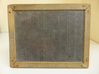
School, Childs School Slate
This slate comes from the Glasgow Estate (Ellen Isabel Glasgow died in Warrnambool in 1971). It is presumed it was used by members of the Glasgow family. Slates such as this were used by all school children in Victoria (and presumably elsewhere) in the infant and younger age classes from the early days of the State until the early 1940s. It had the advantage of the work being able to be easily erased so that other work could be written. A slate pencil was used to write on this board.This is significant firstly as an example of past educational tools used by small children and so has important social significance as every school child of past generations would have used a slate. It is also important as it belonged to the Glasgow family. John Glasgow (c.1847-1925), at his property, Blackwood Hill, Wangoom, was a prominent cheese maker in the late 19th century and was one of the first shareholders and a member of the first Board of Directors of the Warrnambool Cheese and Butter Factory at Allansford. The dairying industry is of key importance in Warrnambool economic history.A slate made from quarry slate with permanent lines for handwriting with a wooden frame. The surface is much marked and scratched. Scratch marksschool slates, educational tools of the past -
 Kiewa Valley Historical Society
Photograph - Folder of Photographs – Photocopied set of black and white photographs (pages 49 -58) from the display folder put together by KVHS to document life on the Kiewa Valley Hydro-electric Scheme
Although the Kiewa Hydro-Electric Scheme was first proposed in 1911, construction did not commence until 1938. As part of the push to cut electricity costs and diversify supply, the Victorian Government (circa 1930) initiated the conversion from primarily brown coal supply to hydro – electricity. Field investigations during the 1940’s resulted in a new proposal for a scheme that had more than double the capacity of the 1938 scheme. The Kiewa Hydroelectric Scheme became the largest scheme of its kind in the State Of Victoria and the second largest scheme in Australia. The number of personnel involved in the planning and construction of the scheme increased dramatically. During the late 1940’s, most activity centred around the construction of the West Kiewa Power Station, Rocky Valley Reservoir, McKay Creek Power Station and the Bogong Creek Aqueduct.A common thread across all the larger hydro scheme constructions was the need for workers, both qualified and unqualified who came from around the world seeking a new life for themselves and their families. New accommodation and facilities were required for the army of workers engaged in construction in often remote and wild areas. The SEC had a high demand for timber, and set up the first of a number of sawmills at Bogong Creek in 1939 and set up the first hardwood logging in the headwaters of the Kiewa River. These new ‘towns’ such as Mt Beauty and Bogong, survived, serving the needs of operational personnel and their families, and expanding with growth of new industries. Mount Beauty, and to a lesser extent Bogong, are among these places. Large A3 size spiral bound display folder containing photocopied black and white photographs of various aspects of the early days of the Kiewa Valley Hydro-electric scheme including equipment, various work sites and photographs of workers and their families. 1-Workmen working inside one of the tunnels. 2-Workman drilling in West Kiewa Tunnel 3-Junction Dam wall construction 4&5-2B&W photographs Kiewa House residents ready to go to a ball in Mt Beauty 6-Workmen warming up in front of a fire at No 1 bench 7-Workmen being hauled in at No 4 P.S Shaft 8-No 4 Power Station – Drilling 9-Workmen eating a hot meal in the tunnel. 10-2 photographs (a)Pretty Valley camp showing workman’s huts and construction materials & (b)Worker in Langford Gap Basalt Hill Tunnel face 11-Tunnel entrance (unlabelled) with rail tracks in foreground 12- Workmen drilling at No 1 Head race tunnel-Drilling face 13- No 1 Power Station 14-Workmen at the entrance to one of the SECV tunnels under construction 1-SECV number at bottom of picture Half obscured possibly K8461 Page number 53 2-In West Kiewa Tunnel Page number 54 3- Construction of Junction Dam wall – approximately 1941 Page number 55 4&5- Residents of Kiewa House at Bogong ready to go to the ball at Mt Beauty-1946. Handwritten on a copy of the photo on opposite page Mrs Lorna Crosset filled out the names *Dad was Des Crossett – his daughter is Gael Petcopoulis Greta engaged to John broke it off. Charlie, Rosalind, Bill, Priscilla, Max Lawrence-Dad’s Boss, Mary & Max married, Mary, Kay, Gwen McPherson Mum’s boss, John McCluskey (c) At No. 5 Bench Page number 56 6- STATE ELECTRICITY COMMISSION OF VICTORIA Date: 27.2.51 Time:2.15pm No K6373 Kiewa Hydro Electric Works No. 4 P.S. Shaft – Haulage of men in buckets (b) As above Handwritten at top of photo Appendix 4 page number 57 7- STATE ELECTRICITY COMMISSION OF VICTORIA Date: 6.6.52 Time:… No K7122 Kiewa Hydro Electric Works No. 4 POWER STATION – DRILLING page number 58 8-No markings page number 59 9-(a)Handwritten under photograph Approx. 1948/49 (b) STATE ELECTRICITY COMMISSION OF VICTORIA Date: 28.10.54 Time:.. No K7860 Kiewa Hydro Electric Works LANGFORD GAP BASALT HILL TUNNEL FACE Page number 49 10-(a) No markings 11- STATE ELECTRICITY COMMISSION OF VICTORIA Date: 20.3.52 Time: No K6979 Kiewa Hydro Electric Works No. 1 HEAD RACE TUNNEL – DRILLING FACE (E.E.E. CONTRACT) ‘The Frenchies’ (E.E.E) as they were affectionately known Page number 50 12-31.5.56 No. 1 Power Station Aggregate Stock Piles. Page number 51 13&14-No markings Page number 52 secv; kiewa hydro electric scheme; bogong; mt beauty; construction area -
 Kiewa Valley Historical Society
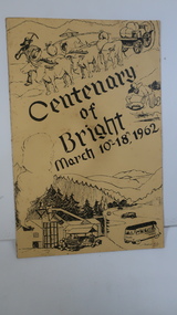
Booklet - Bright, Centenary of Bright March 10th - 18th, 1962
Township of Bright celebrated its centenary during the week from 10th - 18th March, 1962. This booklet outlines the program for the week.Bright is a nearby town to the the Kiewa Valley and currently the location of the current Shire (Alpine). The program gives historical information on activities in the early 1960s.Yellowy/Orange cover with brown title and sketch. One sketch is at the bottom and includes hills, pines, saw mill and bus. Sketch at the top is of a bullock team and in the middle on the right a gold miner. Inside cover has print as has both sides of the 4 pages held by 2 staples. 'C. Roper' on inside of the front cover.bright, centenary of bright -
 Eltham District Historical Society Inc
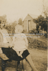
Photograph, Rita Teagle with baby at Thomas Street house, Eltham, c.1938
Rita Teagle House belonged to Tom Fielding's grandparents (Margaret Teagle and Richard Fielding). It was at top of the hill on right hand side (no. 10 Thomas Street, Eltham) Pictured is a bungalow behind the main house. These were added on every time more children came along. Rita was born 1910 and married Horace Maclaughlin in 1935. They had a son, Brian Lawrence Maclaughin (1937). It is presumed that Brian is sitting on Rita's lap and that the date of the photo is c.1938.On reverse "Rita Teagle"brian lawrence maclaughin, eltham, house, ingram family, rita agnes maclaughlin (nee teagle), teagle family, thomas street, pam thoonen (nee ingram) collection -
 Eltham District Historical Society Inc
Map (item) - Sales Brochure, Plenty Township Estate and Bryn Teg Hill's Estate, Coghill & Haughton, Melbourne, c.1924
Plenty Township Estate "The rapid growth of Greensborough and the great traffic development on the main road between Heidelberg and Eltham augurs well for Plenty Township Estate. Already a Store, Post Office and State School have been started, and the activities of the Local Progress Association will help the district forward considerably. Within walking distance of the Montmorency and Greensborough stations." Bryn Teg Hill's Estate "Better known as "The Old Sand Hill, "within walking distance of the Montmorency and Greensborough railways stations." "Some few years back Mrs Thomas subdivided portion of the Sand Hill Paddocks, and the areas sold have been settled and many converted into charming outer suburban garden homes with cultivation and orchard plots. The south-eastern slope gives the land a grand outlook over the Yarra Valley on to the Dandenoings, and the are is very picturesque and homely." "A number of the blocks contain large deposits of valuable building sand, which should prove good speculation in view of the forecast for further rapid home development along the Eltham Suburban Electric Service." Sand Hills Road (Old Eltham Road) Date estimated as c.1924 - Electricification of railway line to Eltham referenced on map occured April 1923 and Mrs Mary Thomas died August 1925. Her home Bryn Teg became part of the Heidelberg Golf Club in 1927.The establishment of Lower Plenty as a suburban growth area supported by easy commuting facilitated by the elctrification of the Eltham railway linebonds road, bridge, bryn teg hill's estate, coghill & haughton, eltham road, heidelberg golf club hotel, houses, lower plenty, lower plenty bridge, lower plenty road, main road, plenty hotel, plenty river, plenty township estate, real estate agent, sales brochure, sand hills road, the old sand hill, sand hill paddocks, woodfull road, old eltham road, bryn teg, mrs m thomas -
 Eltham District Historical Society Inc
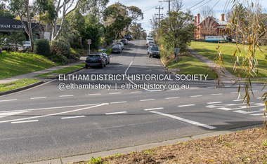
Photograph, Peter Pidgeon, Dalton Street, Eltham, 2 Aug. 2022
View looking up Dalton Street from near Main Road where the former pond was situated. The pond was drained by Council in 1932 due to concerns of mosquitoes, etc against the wishes of long standing residents such as Thekla Jarrold (39 years) and John Clark (22 years). On the right is the Eltham Primary Schoool No. 209 with the former Headmaster's residence and to the left is Eltham Clinic once the site of the Grant home. Comparison photo: SEPP_0643 In April 1935 the local paper reported on a story where a schoolgirl was talking whilst on her bicycle and it started moving off, flying down Dalton Street and across the main road missing cars and the guy wires for the telephone pole and hurtled 21 feet through the air into the drained pond suffering a broken arm and shock. She was rescued unconscious by John and taken into Mrs Jarrold’s for first aid. This was not the only instance of young girls losing control of bicycles down the hill. Part of a presentation by Peter Pidgeon to the Society, 13 August 2022 showcasing a series of photographs taken by John Henry Clark over the period 1895 to 1930. John Henry Clark was the youngest of three boys born to William Henry Clark (1823-1877) and Maria White (1843-1914). He and his brothers, William Charles Clark (1872-1945), Clement Kent Clark (1874-1912) operated a photography business (Clark Bros.) from 25 Thomas Street, Windsor near Prahran during the period c.1894 to 1914. Following death of Clement in September 1912 and their mother in 1914, the Clark Bros business appears to have dissolved, the premises demolished, and a new house was under construction in 1915. John set up business independently in 1914 operating out of 29 Moor Street, Fitzroy where he is registered in the 1914 and 1915 Electoral Rolls. By 1916 John had relocated to Eltham where he continued his practice as a photographer and took many of the early images around the district of Little Eltham. Around 1930 John changed professions and opened a small cobbler's shop in 1931 near the pond opposite Dalton Street adjacent to the Jarrold family cottage. He never married and continued his profession as a bootmaker from this little shop, maintaining a close relationship with Mrs Jarrold for the rest of their lives. His bootmaker shop remains today beside the Whitecloud cottage and is one of only three remaining shops in the area from the early 20th century.Comparative photo taken 2022 with one taken from same location over 100 years earlier by noted local photographer J.H. ClarkBorn Digitaleltham, j.h. clark photo (2022), dalton street, main road, eltham clinic, eltham primary school, headmaster's residence, state school no. 209 -
 Eltham District Historical Society Inc
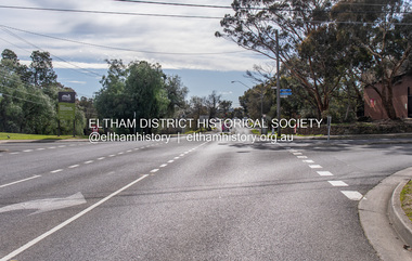
Photograph, Peter Pidgeon, Main Road at Pitt Street, Eltham, 2 Aug. 2022
Main Road looking north from Pitt Street. Comparison photo: SEPP_0626 - Main Road north of Pitt Street, c.1910 On the far left is Mrs Mary Ann Morris' house and shop and Hill's House. William Morris was the publican for the Evelyn Hotel which was on the opposite corner of Pitt Street and Main Road. Also believed to be the Scarce house at some stage, Mrs Emily Scarce was President of the Australian Women's National League. On the right is Webster's then the Commercial Bank of Australia branch, the Methodist Church just behind it on John Street. To the immediate right out of visibility is Watson's Eltham Hotel. Part of a presentation by Peter Pidgeon to the Society, 13 August 2022 showcasing a series of photographs taken by John Henry Clark over the period 1895 to 1930. John Henry Clark was the youngest of three boys born to William Henry Clark (1823-1877) and Maria White (1843-1914). He and his brothers, William Charles Clark (1872-1945), Clement Kent Clark (1874-1912) operated a photography business (Clark Bros.) from 25 Thomas Street, Windsor near Prahran during the period c.1894 to 1914. Following death of Clement in September 1912 and their mother in 1914, the Clark Bros business appears to have dissolved, the premises demolished, and a new house was under construction in 1915. John set up business independently in 1914 operating out of 29 Moor Street, Fitzroy where he is registered in the 1914 and 1915 Electoral Rolls. By 1916 John had relocated to Eltham where he continued his practice as a photographer and took many of the early images around the district of Little Eltham. Around 1930 John changed professions and opened a small cobbler's shop in 1931 near the pond opposite Dalton Street adjacent to the Jarrold family cottage. He never married and continued his profession as a bootmaker from this little shop, maintaining a close relationship with Mrs Jarrold for the rest of their lives. His bootmaker shop remains today beside the Whitecloud cottage and is one of only three remaining shops in the area from the early 20th century.Comparative photo taken 2022 with one taken from same location over 100 years earlier by noted local photographer J.H. ClarkBorn Digitaleltham, j.h. clark photo (2022), main road, pitt street -
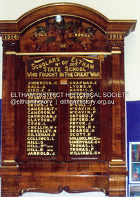 Eltham District Historical Society Inc
Photograph, Doug Orford, 1914-1918 Roll of Honour Board, Eltham State School No. 209, c.2000
1914-1918 Roll of Honour board located at Eltham Primary School Scholars of Eltham No. 209 State School Who Fought In The Great War Anderson, H. Ball, A. Bird, E. * Bromfield, C. * Bromfield, P. Brown, G. * Brown, J. * Cameron, T. * Cameron, W. Carrucan, J. Clayton, T. Cone, L. Crellin, W. * Crossley, N. Gilsenan, H. Gollings, L. Hill, G. Hill, Reg MM Hill, R. MM Jarrold, J. Knapman, E. Lyons, M. Morris, A. Morris, C. Morris, F. Morris, H. McColl, J. McGavin, G. McGavin, P. Orford, F. Orford, W. Pryor, J. Pryor, R. * Scarce, H. Scott, R. Shillinglaw, E. MM Somerville, G. * Thomas, L. Thomas, P. Williams, G. * * - Paid the ultimate sacrifice for their country MM - Awarded the Military Medal1918, a. ball, a. morris, aif, c. bromfield, c. morris, e. bird, e. knapman, e. shillinglaw mm, eltham state school no. 209, f. morris, f. orford, first world war, g. brown, g. hill, g. mcgavin, g. somerville, g. williams, great war, h. anderson, h. gilsenan, h. morris, h. scarce, honour board, honour roll, j. brown, j. carrucan, j. jarrold, j. mccoll, j. pryor, l. cone, l. gollings, l. thomas, m. lyons, n. crossley, p. bromfield, p. mcgavin, p. thomas, r. hill mm, r. pryor, r. scott, reg hill mm, roll of honour, t. cameron, t. clayton, w. cameron, w. crellin, w. orford, ww1, eltham primary school -
 Eltham District Historical Society Inc
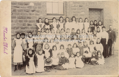
Photograph, Theodor Black, Girl Students, Eltham State School No. 209, c.1904
Photo taken at the east end of the school. 1. Head Teacher John Brown served as HT from 1889 to his death in Sept 1906. 2. 53 Girls and 42 boys - 95 - attendance figures known between 1899 and 1906. 3. Female teacher in both photohraphs is Miss Amy E Barrowclough (Oct 1900 through 1904) [150th anniversary book incorrectly identifies her as Ellen Sweeney] 4. Youth in doorway is the Monitor, Harold Gilsenan (1904) 5. Post and rail fencing along Dalton Street (seen behind John Brown) was built in the upgrade of 1903 These facts date the photographs to be c.1904-c.1905 [Harry Gilham] Ina Falkiner is top row 4th from left Gertrude Falkiner is bottom row seated 4th from left. (Identified by Gertrude's garnddaugher and Ina's great neice, Judith Vun, email 26 May 2022) John Brown died 23 Sept 1906 after a short severe illness at age 55 and is buried in Box Hill Cemetery (Evelyn Observer 28 Sep 1906 p2). The book "We did open a school in Little Eltham" incorrectly states his date of death as 16/12/1906. Title The Evelyn Observer. (1906, September 28). Evelyn Observer and Bourke East Record (Vic. : 1902 - 1917), p. 2 (MORNING.) Url http://nla.gov.au/nla.news-article61129880 Description It is with sincere regret we record the death of Mr. John Brown, State school teacher, Eltham, which sad event took place at his residence, "Pine Brae," on Sunday night last, 23rd inst. after a severe illness of some few weeks' duration. The deceased gentleman was highly respected, and always took a lively and active interest in promoting the progress and prosperity of the district, and his loss will be much felt, He was only 55 years of age, and leaves a wife and large family to mourn their loss, and much sympathy is felt for them. The remains of the deceased were interred in the Box Hill cemetery on Wednesday afternoon last. PANEL 1875-1920 Panels began to be produced around 1875, and were particularly suited, because of their larger size, for capturing family, or even larger, groups. They measured 8.5 by 6.5 inches (22 cm x 16.5 cm). - Frost, Lenore; Dating Family Photos 1850-1920; Valiant Press Pty. Ltd., Berwick, Victoria 1991marg ball collection, shillinglaw family photo album 3, class photo, eltham primary school, eltham state school no. 209, 1904, gretrude falkiner, ina falkiner, john brown, miss amy e barrowclough, state school no. 209, theodor black photographer -
 Eltham District Historical Society Inc
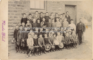
Photograph, Theodor Black, Boy students, Eltham State School No. 209, c.1904
Photo taken at the east end of the school. 1. Head Teacher John Brown served as HT from 1889 to his death in Sept 1906. 2. 53 Girls and 42 boys - 95 - attendance figures known between 1899 and 1906. 3. Female teacher in both photohraphs is Miss Amy E Barrowclough (Oct 1900 through 1904) [150th anniversary book incorrectly identifies her as Ellen Sweeney] 4. Youth in doorway is the Monitor, Harold Gilsenan (1904) 5. Post and rail fencing along Dalton Street (seen behind John Brown) was built in the upgrade of 1903 These facts date the photographs to be c.1904-c.1905 [Harry Gilham] Ina Falkiner is top row 4th from left Gertrude Falkiner is bottom row seated 4th from left. (Identified by Gertrude's garnddaugher and Ina's great neice, Judith Vun, email 26 May 2022) John Brown died 23 Sept 1906 after a short severe illness at age 55 and is buried in Box Hill Cemetery (Evelyn Observer 28 Sep 1906 p2). The book "We did open a school in Little Eltham" incorrectly states his date of death as 16/12/1906. Title The Evelyn Observer. (1906, September 28). Evelyn Observer and Bourke East Record (Vic. : 1902 - 1917), p. 2 (MORNING.) Url http://nla.gov.au/nla.news-article61129880 Description It is with sincere regret we record the death of Mr. John Brown, State school teacher, Eltham, which sad event took place at his residence, "Pine Brae," on Sunday night last, 23rd inst. after a severe illness of some few weeks' duration. The deceased gentleman was highly respected, and always took a lively and active interest in promoting the progress and prosperity of the district, and his loss will be much felt, He was only 55 years of age, and leaves a wife and large family to mourn their loss, and much sympathy is felt for them. The remains of the deceased were interred in the Box Hill cemetery on Wednesday afternoon last. PANEL 1875-1920 Panels began to be produced around 1875, and were particularly suited, because of their larger size, for capturing family, or even larger, groups. They measured 8.5 by 6.5 inches (22 cm x 16.5 cm). - Frost, Lenore; Dating Family Photos 1850-1920; Valiant Press Pty. Ltd., Berwick, Victoria 1991marg ball collection, shillinglaw family photo album 3, class photo, eltham primary school, eltham state school no. 209, 1904, harold gilsenan, john brown, miss amy e barrowclough, state school no. 209, theodor black photographer -
 Glen Eira Historical Society
Document - Ontario Street Methodist Church
Brief printed history of Ontarios Street Methodist Church compiled by Gwenda Mann from minute books at Uniting Church Archives. Period covered 1921 to 1975. Printed memories of Ontario Street, compiled by Gwen Stafford around 1989-1990 covering the period 1928-1987.methodist church, lempriere street, ontario street, caulfield north, davies j., pettitson mr., denmead mr., ponsford mr., shannon r., mclellan john, alday t. rev., overend h. a. rev., burns h.m. rev., mccallum dr., mccure r. mr., choirs, josephs p., palmer phillips h. rev., petterson c.m., davies jack, cartwright w.b., halls, architects, browning mr., bladen mr., alday mrs., gyngell mrs., eskdale road, kurl mrs., roberts n. mrs., butler j. mrs., williams g., morey m. mrs., williams miss, salmon mr., turner mrs., salmon mrs., hefford mrs., williams c., marsden miss, briaris miss, orrong road methodist church, harris s.s., griffith t.r., wilson a.r., warfe j.e., mclean r.c., mckay h.g., mann gwenda, stafford gwen, choirs, ladies guild, halls, sunday schools, women’s australian and overseas mission, elsternwick – st.kilda circuit, palamountain rev., barnes mr., sunday school, trivett mr., stafford evan, hauser geoff, hauser betty, hauser connie, austin keith, cunnington fred, peterson reg, tregear rev., trivett family, denmead family, davis family, kinderman family, clarke family, light family, dark family, brown family, salmon family, andrewatha family, 2 phillip families, cunnington family, kennedy family, geer family, peterson family, william family, watkins family, jones family, lambden family, stafford e.r., stafford ray, watts family, bearson family, redman family, youren family, hill family, pullen family, walters family, weber family, boness family, allen family, cowlishaw family, davies j., kinderman r., trivett w., brown f., brown r., salmon f., wedlock w., boness j., stafford e.r., denman c., walters c., harris selwyn rev., wilson ray rev., mclean roy rev., warfe john rev., griffen tom rev., mckay harry rev., kinder gardens, king dorothy, ritchie clarice, balchin, phillips lila, geer keith, atkinson mrs., beason gwen, tennis clubs, beason tas mr., choirs, watkins clarrie, williams ray rev., butler rev., haynes fred rev., wilson gus rev., jones barry, waldron glen, yeatman john dr., kooyong road church, halls, stafford gwen -
 Eltham District Historical Society Inc
Negative - Photograph, Coghill & Haughton, On the banks of the Plenty, c.1924
Negative copy and associated print of detail from original Sales Brochure: Plenty Township Estate and Bryn Teg Hill's Estate, Coghill & Haughton, Melbourne (c.1924)Roll of 35mm Black and White negative film, 3 strips, (1 of 14 frames) Print 10 x 15 cmFilm - Agfa Ortho 25bridge, bryn teg, bryn teg hill's estate, coghill & haughton, heidelberg golf club hotel, houses, lower plenty, lower plenty bridge, lower plenty road, main road, mrs m thomas, plenty river, plenty township estate, real estate agent, sales brochure -
 Eltham District Historical Society Inc
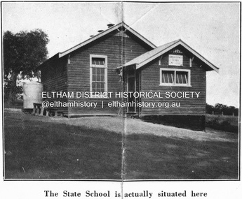
Negative - Photograph, Coghill & Haughton, Original Lower Plenty School, c.1924
Negative copy and associated print of detail from original Sales Brochure: Plenty Township Estate and Bryn Teg Hill's Estate, Coghill & Haughton, Melbourne (c.1924)Roll of 35mm Black and White negative film, 3 strips, (1 of 14 frames) Print 10 x 15 cmFilm - Agfa Ortho 25lower plenty, lower plenty state school no. 1295, bryn teg hill's estate, coghill & haughton, sales brochure -
 Eltham District Historical Society Inc
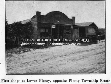
Negative - Photograph, Coghill & Haughton, First shops at Lower Plenty opposite Plenty Township Estate, c.1924
Negative copy and associated print of detail from original Sales Brochure: Plenty Township Estate and Bryn Teg Hill's Estate, Coghill & Haughton, Melbourne (c.1924)Roll of 35mm Black and White negative film, 3 strips, (1 of 14 frames) Print 10 x 15 cmFilm - Agfa Ortho 25lower plenty, bryn teg hill's estate, coghill & haughton, sales brochure, main road, plenty-township-estate, shops -
![Negative - Photograph, Coghill & Haughton, A Beautiful Home on the Plenty [Yallambie, Lower Plenty], c.1924](/media/collectors/4f729f7b97f83e03086018a5/items/62365fb2c8228c0f0d9ff3d8/item-media/6600e1625527135282394551/item-fit-380x285.jpg) Eltham District Historical Society Inc
Eltham District Historical Society IncNegative - Photograph, Coghill & Haughton, A Beautiful Home on the Plenty [Yallambie, Lower Plenty], c.1924
... Estate, Coghill & Haughton, Melbourne (c.1924) Bryn Teg Hill's ...Negative copy and associated print of detail from original Sales Brochure: Plenty Township Estate and Bryn Teg Hill's Estate, Coghill & Haughton, Melbourne (c.1924)Roll of 35mm Black and White negative film, 3 strips, (1 of 14 frames) Print 10 x 15 cmFilm - Agfa Ortho 25bryn teg hill's estate, coghill & haughton, sales brochure, houses, lower plenty, plenty-river, yallambie -
 Eltham District Historical Society Inc
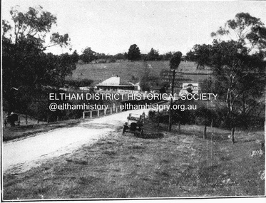
Negative - Photograph, Coghill & Haughton, Old bridge over the Plenty River near Plenty Hotel, c.1924
... Estate, Coghill & Haughton, Melbourne (c.1924) Bryn Teg Hill's ...Negative copy and associated print of detail from original Sales Brochure: Plenty Township Estate and Bryn Teg Hill's Estate, Coghill & Haughton, Melbourne (c.1924)Roll of 35mm Black and White negative film, 3 strips, (1 of 14 frames) Print 10 x 15 cmFilm - Agfa Ortho 25bryn teg hill's estate, coghill & haughton, sales brochure, lower plenty, bridge, hotels, lower-plenty-road, plenty-hotel, plenty-river -
 Eltham District Historical Society Inc
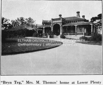
Negative - Photograph, Coghill & Haughton, 'Bryn Teg', Mrs M. Thomas' home at Lower Plenty, c.1924
... Estate, Coghill & Haughton, Melbourne (c.1924) Bryn Teg Hill's ...Negative copy and associated print of detail from original Sales Brochure: Plenty Township Estate and Bryn Teg Hill's Estate, Coghill & Haughton, Melbourne (c.1924)Roll of 35mm Black and White negative film, 3 strips, (1 of 14 frames) Print 10 x 15 cmFilm - Agfa Ortho 25bryn teg hill's estate, coghill & haughton, sales brochure, lower plenty, bryn teg, houses, mrs m thomas, plenty township estate, real estate agent -
 Eltham District Historical Society Inc
Negative - Photograph, Coghill & Haughton, Plenty River at Lower Plenty, c.1924
... Estate, Coghill & Haughton, Melbourne (c.1924) Bryn Teg Hill's ...Negative copy and associated print of detail from original Sales Brochure: Plenty Township Estate and Bryn Teg Hill's Estate, Coghill & Haughton, Melbourne (c.1924)Roll of 35mm Black and White negative film, 3 strips, (1 of 14 frames) Print 10 x 15 cmFilm - Agfa Ortho 25bryn teg hill's estate, coghill & haughton, sales brochure, lower plenty, plenty river -
 Eltham District Historical Society Inc
Negative - Photograph, Coghill & Haughton, Typical scene on the Plenty River at Lower Plenty, c.1924
... Estate, Coghill & Haughton, Melbourne (c.1924) Bryn Teg Hill's ...Negative copy and associated print of detail from original Sales Brochure: Plenty Township Estate and Bryn Teg Hill's Estate, Coghill & Haughton, Melbourne (c.1924)Roll of 35mm Black and White negative film, 3 strips, (1 of 14 frames) Print 10 x 15 cmFilm - Agfa Ortho 25bryn teg hill's estate, coghill & haughton, sales brochure, lower plenty, plenty river -
 Eltham District Historical Society Inc
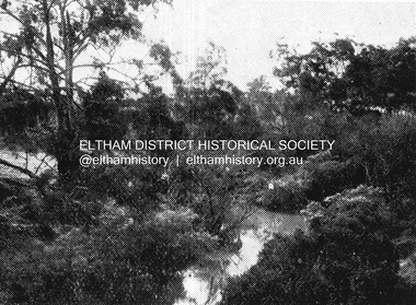
Photograph, Tess Justine (Nillumbik Shire Council), Murray's Bridge over the Diamond Creek, Eltham North, 19 Feb 2022
Murray's Bridge over the Diamond Creek on the Diamond Creek Trail just prior to demolition and replacement with a new steel bridge. Heritage advice obtained by Nillumbik Shire Council, following a suggestion by the Eltham District Historical Society (EDHS), is that the original bridge appears to have been a simplified version of the Country Roads Board’s (CRB) standard timber bridge design of the early-to-mid 1920s. In c1990 Murray’s bridge was renovated with three recycled steel girders as part of a bike/pedestrian path in the reserve. During these alterations many parts of the bridge were removed, and some were replaced. Heritage advice indicates the condition of Murray’s bridge is poor. The remaining original parts are all in poor condition, with severe weathering, splitting and rot, especially to the stringers retained on the bridge. Heritage advice is that Murray’s Bridge does not have sufficient significance in the cultural history of the Nillumbik area to warrant inclusion in the Nillumbik Shire Heritage Overlay and also does not have sufficient significance as a rare survivor to warrant inclusion in the Nillumbik Shire Heritage Overlay. There are no indications in the historical record that this site was individually important to the cultural history of this area. EDHS is comfortable with the heritage advice provided to Council and has worked closely on this project with Council. EDHS has suggested some of the removed timbers be used in the vicinity of the bridge for landscaping and possibly seating, so as to retain these remnants close to the site of the original bridge, which is the last old timber bridge along the lower reaches of the Diamond Creek. Mary (Sweeney) Murray and John Wright Murray selected 80 acres, Lot C Section 16 and Lot 5 Section 17 Parish of Nillumbik, under an occupation license in 1866. John died in 1867 and freehold was granted to his son John in 1873. The farm was known as ‘Laurel Hill’. John Junior was an Eltham Shire councillor and sometime president from 1887 up until 1897. He added Lot A Section 16 to the farm in ca1888. John and his younger brother James arranged to rent/purchase Lot B Section 17, across Diamond Creek to the west, in ca1900. It appears that John and James farmed separately for a few years, with a new homestead built for James ad family on the high point of Lot B Section 17 in ca1910. John sold off Lot 5 Section 17 in 1912. When John died in 1912 James took over the land on both sides of the Diamond Creek. The old homestead on the west side of the Creek disappeared. A farm bridge over Diamond Creek from this period may have been located close to the northern boundary of the farm. John Langlands, owner of the farm known as ‘Ihurst’ on the west side of Diamond Creek to the south of the Murray’s land, died in 1907. In 1909 his land was then subdivided into 100 lots to become the ‘Glen Park Estate’. Other similar subdivisions of nineteenth century farms around Eltham in this period included the ‘Franktonia (or Beard’s) Estate’ to the northeast and ‘Bonsack’s Estate’ between Eltham and Greensborough. Soon after the opening of the railway extension line from Eltham to Hurstbridge in 1912, Glen Park and nearby residents including James Murray agitated for a railway station or siding to be located half-way between Eltham and Hurstbridge, so that the Glen Park residents who used the railway daily did not have to walk into the Eltham or Hurstbridge stations. Some believed Coleman’s Corner (opposite Edendale Farm) was an appropriate spot for the platform. James Murray was among those who thought the railway should be located on his land, closer to half-way between Eltham and Hurstbridge stations. The Railways Commissioners warned that the locals would have to fund these works themselves. The Glen Park Estate residents initially had difficulty accessing Eltham by road, with only an old low-level bridge over Diamond Creek at the south end of their estate. A new timber trestle bridge across the creek, now on Wattletree Road, was opened in 1915. Road access to the north was gained in 1927 when the new Murray’s Road, which crossed the Murray’s land, was built. Residents continued to agitate for a Glen Park station. By 1926 the Railways Commissioners’ preferred site was on the Murray’s land. They arranged an estimate of cost of a full-length platform. The estimate was too much for the locals, who in 1928 argued unsuccessfully for a shorter and hence cheaper platform. By 1929 Murray had agreed to donate the land, but the locals would still have to fund the works. Murray decided, unilaterally it would appear, to commence work on a timber trestle road bridge over Diamond Creek to link the new Murray Road to the proposed station. Late in 1929 he stopped work on the bridge, for reasons unknown, but started work again and completed the bridge in 1931. There is no further newspaper evidence of the campaign for the Glen Park station until 1939, when Murray and another local, Mr Maxwell, met the Railways Commissioner. The Glen Park locale now included 45 homes on the west side of the creek and 20 on the Eltham side. Most of the residents used the train every day. The Commissioner remained adamant that only a full-length platform could be built for safety reasons. It appears the campaign dissolved at this point. The increasing move to cars may have had an impact. There is no evidence of Murray’s bridge ever being connected to Murray’s Road, or of it having wide use for any purpose by locals. James Murray died in 1947 and the farm was taken over by his son James (Jim). Jim started to sell off parts of the farm in the 1980s, retaining a few acres around the ca1910 homestead and building a new house there. Recreation reserves were established along the creek. In ca1990 Murray’s bridge was renovated with steel girders as part of a bike/pedestrian path in the reserve. The old farmhouse was demolished in ca2014. * * * A theory posted on local community Facebook groups was that the bridge was built in the 1860s and was built to be more robust than was necessary for the movement of cows from one side of the creek to the other. It was suggested the robustness was necessary to support the weight of gold ore being transferred from a mine on Murray’s land to a railway siding near Murrays Bridge (presumably for transfer and processing at Diamond Creek). Perhaps this may have been one of the motivators for Murray, who really knows? Knowing when mining operations ceased on his land and how that fits the overall timeline would be useful but at the time the bridge was built, local gold production was minimal at best. The known facts are: • The railway line came to Eltham in 1902. • The extension of the railway from Eltham to Hurstbridge was constructed in 1912 so no railway line even existed through Murray's property until 1912 and the Victorian Railways maps at the time show no such siding on Murray’s property. • In 1923 a new company was formed in anticipation of the old Diamond Creek Gold Mine being re-opened. The mine had been previously closed and flooded. It was noted in the press at the time that the mine was within a mile of the railway. Nothing really came of this. • Construction of Murrays Bridge was commenced by James Murray in early 1929 in anticipation of a proposed flag station being nominated on his land, but work ceased shortly afterwards. The proposed flag station was commonly referred to as Glen Park as the residents of the Glen Park Estate wanted Option 1, located near them with the platform adjacent to Colemans corner. This was probably never going to fly as it was virtually in eyesight of Eltham station. Allandale Road was the third option, but the Commissioners' preferred option was No. 2 - on Murray's property. • The Railway Commissioners were not going to finance any such station and the works had to be funded by private landowners and residents, hence Murray investing in this himself. • Murray recommenced work two years later and finished his bridge in 1931 but unfortunately for him, the proposed flag station never eventuated. The bluestone siding you reference may well have been built by Murray as part of the proposed station platform. • Up until then, apart from the Main Road bridge, which was washed away in 1924, virtually all local crossings over the Diamond Creek were low lying bridges – Kaylocks Bridge at Brougham Street, Diamond Street bridge, Glen Park Road bridge. It is expected that Murray also had a low-lying bridge to connect his land either side of the creek. These were all washed away or severely damaged multiple times in the 1920s. Lessons were learnt, and Murrays Bridge appears to have been built in accordance with Country Road Board standards of the time. Flood damage was ongoing, and even more recently constructed raised bridges kept getting washed away, e.g., the new Wattle Tree Road bridge in 1958 just months after completion. Murray’s bridge was reinforced with steel some 30 years ago presumably to provide additional floodwater resistance, given the history of bridges disappearing in floodwaters. • In March 1932 it was reported in the Advertiser that there were still some prospectors operating around Eltham North who apart from further scarring the face of the earth over the previous two years had gained significant experience but little gold - hardly a driving factor for constructing a dedicated railway siding and bridge to transfer gold ore. It is far more probable that James Murray was hoping to have the railway station located on his property and invested his money by building the bridge to lead to it as well as a station platform. Had the station eventuated, it may well have driven up the value of his land for subdivision and new housing estates like the Glen Park Estate. That did not eventuate. Whilst the bridge was indeed old (90 years), the core structure being completed in 1931, it had been modified substantially from original and hence had no significant historic value – i.e., it was not a representative example of its type, construction, and age. Given that the bridge was not worthy of saving, the Eltham District Historical Society with Council’s support, and the Eltham Woodworkers group endeavoured to see what suitable sized timbers were salvageable to fabricate a commemorative seat. Unfortunately, the experts at the Woodworkers group were unable to salvage any suitable length/width timbers to fabricate the seat due to the presence of rot. Last remaining wooden trestle bridge on the Diamond Creek Trail just prior to demolition and replacementBorn digital image (27)diamond creek (creek), diamond creek trail, murrays bridge, ‘laurel hill’, john wright murray, mary (sweeney) murra, john murray jnr, james murray, john langlands, ‘ihurst’, ‘glen park estate’, beard's estate, franktonia, bonsack's estate, glen park estate, glen park railway station -
 Eltham District Historical Society Inc
Photograph, Tess Justine (Nillumbik Shire Council), Construction work on replacement of Murray's Bridge over the Diamond Creek, Eltham North, 31 Mar 2022
Construction work on replacement of Murray's Bridge over the Diamond Creek on the Diamond Creek Trail Mary (Sweeney) Murray and John Wright Murray selected 80 acres, Lot C Section 16 and Lot 5 Section 17 Parish of Nillumbik, under an occupation license in 1866. John died in 1867 and freehold was granted to his son John in 1873. The farm was known as ‘Laurel Hill’. John Junior was an Eltham Shire councillor and sometime president from 1887 up until 1897. He added Lot A Section 16 to the farm in ca1888. John and his younger brother James arranged to rent/purchase Lot B Section 17, across Diamond Creek to the west, in ca1900. It appears that John and James farmed separately for a few years, with a new homestead built for James ad family on the high point of Lot B Section 17 in ca1910. John sold off Lot 5 Section 17 in 1912. When John died in 1912 James took over the land on both sides of the Diamond Creek. The old homestead on the west side of the Creek disappeared. A farm bridge over Diamond Creek from this period may have been located close to the northern boundary of the farm. John Langlands, owner of the farm known as ‘Ihurst’ on the west side of Diamond Creek to the south of the Murray’s land, died in 1907. In 1909 his land was then subdivided into 100 lots to become the ‘Glen Park Estate’. Other similar subdivisions of nineteenth century farms around Eltham in this period included the ‘Franktonia (or Beard’s) Estate’ to the northeast and ‘Bonsack’s Estate’ between Eltham and Greensborough. Soon after the opening of the railway extension line from Eltham to Hurstbridge in 1912, Glen Park and nearby residents including James Murray agitated for a railway station or siding to be located half-way between Eltham and Hurstbridge, so that the Glen Park residents who used the railway daily did not have to walk into the Eltham or Hurstbridge stations. Some believed Coleman’s Corner (opposite Edendale Farm) was an appropriate spot for the platform. James Murray was among those who thought the railway should be located on his land, closer to half-way between Eltham and Hurstbridge stations. The Railways Commissioners warned that the locals would have to fund these works themselves. The Glen Park Estate residents initially had difficulty accessing Eltham by road, with only an old low-level bridge over Diamond Creek at the south end of their estate. A new timber trestle bridge across the creek, now on Wattletree Road, was opened in 1915. Road access to the north was gained in 1927 when the new Murray’s Road, which crossed the Murray’s land, was built. Residents continued to agitate for a Glen Park station. By 1926 the Railways Commissioners’ preferred site was on the Murray’s land. They arranged an estimate of cost of a full-length platform. The estimate was too much for the locals, who in 1928 argued unsuccessfully for a shorter and hence cheaper platform. By 1929 Murray had agreed to donate the land, but the locals would still have to fund the works. Murray decided, unilaterally it would appear, to commence work on a timber trestle road bridge over Diamond Creek to link the new Murray Road to the proposed station. Late in 1929 he stopped work on the bridge, for reasons unknown, but started work again and completed the bridge in 1931. There is no further newspaper evidence of the campaign for the Glen Park station until 1939, when Murray and another local, Mr Maxwell, met the Railways Commissioner. The Glen Park locale now included 45 homes on the west side of the creek and 20 on the Eltham side. Most of the residents used the train every day. The Commissioner remained adamant that only a full-length platform could be built for safety reasons. It appears the campaign dissolved at this point. The increasing move to cars may have had an impact. There is no evidence of Murray’s bridge ever being connected to Murray’s Road, or of it having wide use for any purpose by locals. James Murray died in 1947 and the farm was taken over by his son James (Jim). Jim started to sell off parts of the farm in the 1980s, retaining a few acres around the ca1910 homestead and building a new house there. Recreation reserves were established along the creek. In ca1990 Murray’s bridge was renovated with steel girders as part of a bike/pedestrian path in the reserve. The old farmhouse was demolished in ca2014. Born digital image (5)diamond creek (creek), diamond creek trail, murrays bridge, ‘laurel hill’, john wright murray, mary (sweeney) murra, john murray jnr, james murray, john langlands, ‘ihurst’, ‘glen park estate’, beard's estate, franktonia, bonsack's estate, glen park estate, glen park railway station -
 Eltham District Historical Society Inc
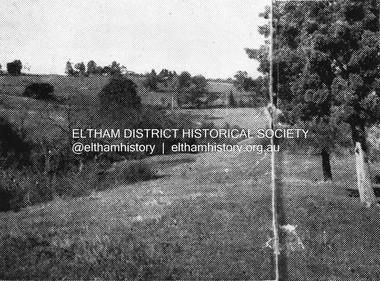
Slide - Photograph, Aerial Photo (c.1987): Sherbourne Road overpass, Briar Hill, c.Aug. 1990
Part of a presentation, "Roads and Byways of the Shire of Eltham", by Russell Yeoman to the 12 September 1990 Society meeting. Slides shown included copies of old photos and recent images ranging from the suburban streets of Eltham and Montmorency to the mountain roads of Kinglake. In the byways category are views of some iof the Shire's bicycle paths including then recently completed sections of the Main Yarra Trail at Lower Plenty.35mm colour positive transparency (1 of 37) Mount - Agfachrome Agfa CS System black 8 dotsinfrastructure, roads, aerial photographs, briar hill, overpass, para road, railway bridge, sherbourne road -
 Eltham District Historical Society Inc
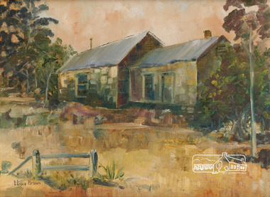
Painting, C. Lillie Brown, Briar Hill Cottage by C. Lillie Brown
... Briar Hill Cottage by C. Lillie Brown... Briar Hill Cottage by C. Lillie Brown Painting Painting C ...Painting by C. Lillie Brown (Caroline) of house at 25 Beaconsfield Road, Briar Hill, formnerly owned by Miss Humphries who ran a lolly shop in the left hand sode of the building. Frequented by children from the Briar Hill school which was opposite. House now demolished.29.2 x 39.1 cm Oil on (Fredrix USA) linen mounted paper board 12" x 16 " (30.5 x 40.6 cm) in standard frame Signed in brown paint lower left C Lillie Brown25 beaconsfield road, briar hill, miss humphries, lolly shop, briar hill school