Showing 6379 items
matching Mining
-
 Stawell Historical Society Inc
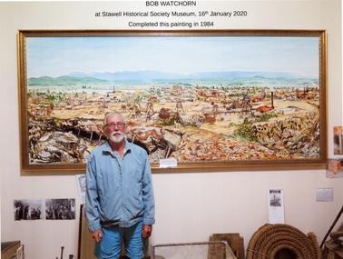
Photograph, Mr Bob Watchorn with his Painting of Stawell
Completed in 1984 by Bob Watchorn gold, mining, panorama -
 Stawell Historical Society Inc
Photograph, Panorama of Wonga Open Cut 1984
mining, gold, panorama -
Stawell Historical Society Inc
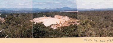
Photograph, Panorama of Davis Open Cut August 1987
mining, gold, panorama -
 Stawell Historical Society Inc
Photograph, Panorama of Davis Open Cut August 1987
mining, gold, panorama -
 Stawell Historical Society Inc
Photograph, Panorama of Davis Open Cut August 1987
mining, gold, panorama -
Stawell Historical Society Inc
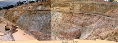
Photograph, Davis Open Cut West Wall North End
Photo of Stripping 1987mining, gold, panorama -
Stawell Historical Society Inc
Photograph, Davis Open Cut 24/28 meter South Wall 1987
mining, gold, panorama -
Stawell Historical Society Inc
Photograph, Davis Open Cut 1987
mining, gold, panorama -
Stawell Historical Society Inc
Photograph, Davis Open Cut East Wall North End 1988
mining, gold, panorama -
 Stawell Historical Society Inc
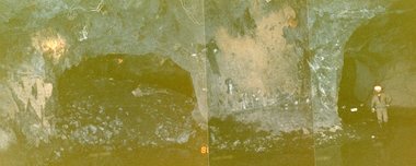
Photograph, Stawell Gold Mine, Stawell Gold Mine Drives Underground 1988
Workers standing in Stawell Gold Mine Underground Drives. One Drive showing rock backfillpanorama, gold, mining -
Stawell Historical Society Inc
Photograph, Panorama of Stawell from Big Hill
Two sets of Four Photographs gold, mining, panorama -
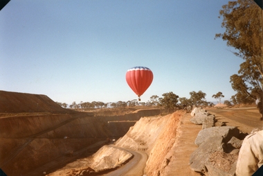 Stawell Historical Society Inc
Photograph, Balloon over Wonga Opencut
Wonga Open Cut 1988gold, mining, tourism -
Stawell Historical Society Inc
Map, Department of Mines Victoria, The Reefs. The Principle Reefs at Quartz Reefs, 1868
c1868 Map showing the position of principal Reefs at Quartz ReefsTracing Shewing the position of the principle reefs at Quartz Reefs. Scale 8 Chains to an inch mining, gold, map -
Stawell Historical Society Inc
Map, Department of Mines Victoria, Alluvial Map Stawell Region, 1870's
c1870 Coloured map showing Black Range North to Stawell and Illawarra. Shows geological layout.Department Mines Victoria 1952/G/2 mining, gold, map -
Stawell Historical Society Inc
Map, Stawell Gold Mine, Provisional Plan Wonga Area, c1980
c1980 Preliminary Provisional Reconnaissance Plan Showing Workings Above and Below water LevelWonga Area 1:1000 Base Geological Sheet mining, gold, map -
Stawell Historical Society Inc
Map, Geological Survey Office, Sloanes & Scotchmans united Mine, December 1916
Sloane & Scotchman's Geological Survey Map 1916 Showing Underground DrivesGeological Survey Office Ballarat December 1916 mining, gold, map -
Stawell Historical Society Inc
Map, Charles C Reilly, Oriental & North Cross Reef Mine showing underground drives, 3/5/1900
Underground Survey of Mines Stawell c1900Charles C Reilley 3.5.00 mining, gold, map -
Stawell Historical Society Inc
Map, Sloanes & Scotchmans Company showing underground drives, c1900
Underground Workings Mapc1900Sloanes & Scotchmans Coy mining, gold, map -
Stawell Historical Society Inc
Map, Gold Mines of Australia, Gold Mines of Australia underground workings. Newington Rd Darlington Rd Area 1950, 1950
Plans Showing Surveys & Drilling Stawell InvestmentGold Mines of Australia Stawell Investment 2003 mining, gold, map -
Stawell Historical Society Inc
Map, Gold Mines of Australia, Geological Plan Wonga Mine Area Stawell Investigation, 1950
Plans Showing Stawell Investment 1950Gold Mines of Australia Ltd mining, gold, map -
Stawell Historical Society Inc
Map, Gold Mines of Australia, Stawell Investment Geological Plan. Mine Area showing Mineshafts
The Reefs Mine shaft locationsGold Mines of Australia Ltd mining, gold, map -
Stawell Historical Society Inc
Map, Stawell Gold Mine, SGM Mineralized System Longitudinal Projection showing Diamond Drilling Holes 2007, June 2007
Section of Big Hill showing Diamond Drill holes through Magdala, Magdala North and Golden Gift Ore bodies to 2000m levelLegend of Mine workings numbered. 1980's mining, gold, map -
Stawell Historical Society Inc
Map, Crocodile Gold Corp, Photographic Aerial View of Big Hill showing underground workings and surface workings and proposed Big Hill Open Pit proposal, December 2014
Crocodile Gold Corp SGM photo Map showing Magdala Decline& Wonga Decline December 2014 Produced for Public Consultation over Big Hill Open Pit Proposal. Aerial Views Stawellmining, gold, map -
Stawell Historical Society Inc
Map, Stawell Joint Venture, Mine Site Detail Plan, September 1989
1989mining, gold, map -
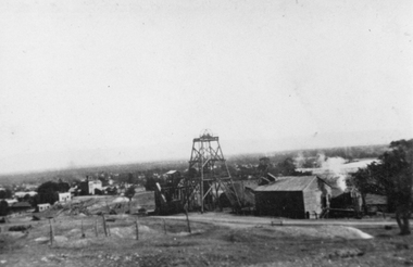 Stawell Historical Society Inc
Photograph, Sloanes & Scotchmans Mine
Poppet Head and Engine House of Sloane & Scotchmans United Mine taken from Big Hill Facing North West. c 1915 to 1920mining, panorama, gold -
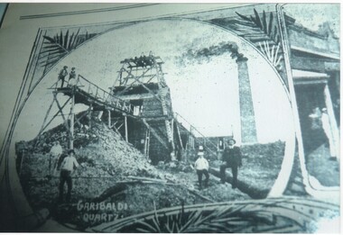 Rutherglen Historical Society
Image
Copied photograph of Garibaldi Quartz Mine. Original believed to have been taken about 1894.On back of photo: "1894"mining, gold mining, garibaldi mine -
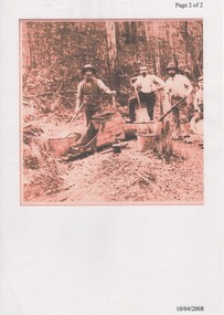 Rutherglen Historical Society
Image, c1860
Photocopy of a sepia toned photograph of three gold miners with a rocker box and other hand equipment.Comment written on file folder "re Wilson & Bell"gold mining, mining, rocker box -
 Rutherglen Historical Society
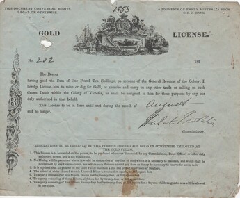
Document, Gold Licence No 202, 1963-1980 (approx)
Regulations to be observed by the persons digging for gold or otherwise employed at the golf fieldsTattered document on blue-green paper. Replica of a gold license, issued as "A souvenir of early Australia from the C.B.C. Bank""1853" handwritten at centre top of documentgold, licence, mining -
 Ballarat Heritage Services
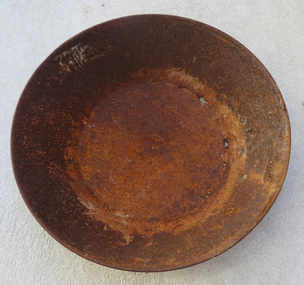
Photograph, Clare Gervasoni, Metal Gold Pan, 2017
A gold pan was used to wash alluvial gold from gravel and dirt.Colour photographs of a large gold pan.gold pan, mining, gold mining tools tools -
 Ballarat Heritage Services
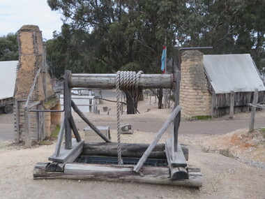
Photograph - Colour, Windlass at Sovereign Hill, 2015, 03/03/2015
Colour photograph of a windlass at Sovereign Hill, Ballarat East.sovereign hill, windlass, mining