Showing 2271 items matching aerial
-
 Running Rabbits Military Museum operated by the Upwey Belgrave RSL Sub Branch
Aerial
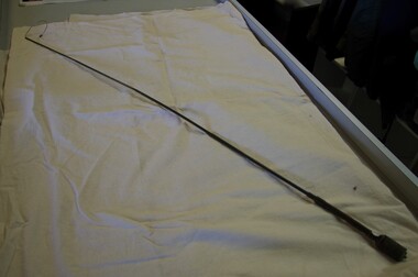
long radio aerialequipment, vietnam, army -
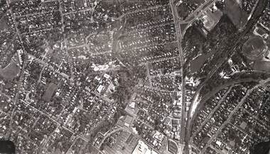
 Ringwood and District Historical Society
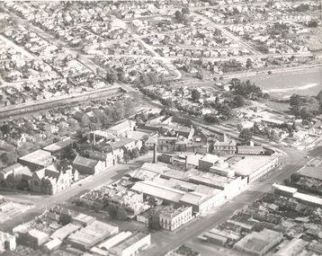
Aerial Map, R.A.A.F, Aerial photograph of Mitcham and part of Ringwood (RAAF) 1931, 1931
Aerial photographs of Mitcham and part of Ringwood by RAAF 1931 with a covering explanatory text. The quality of the picture is poor as it is a copy of a paper copy. Page signed by Ken Baxter.1.Aerial photographs of Mitcham and part of Ringwood by RAAF 1931 - B&W.; 2. Text with explanations - white A4 page. +Additional Keywords: Baxter, Ken -
 Federation University Historical Collection
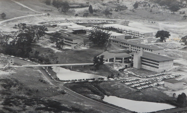
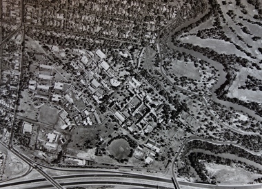
Photograph - Photograph - Black and White, Ballarat College of Advanced Education, Aerial view of the Mt Helen campus from the north, c1975
black and white photograph: Aerial view of Mt Helen campus from the north mount helen campus, mount helen campus aerial, student residences, p building, f building, g building, l building, mt helen library, union building, u building, e.j. barker library, aerial -
Stawell Historical Society Inc
Map, Crocodile Gold Corp, Photographic Aerial View of Big Hill showing underground workings and surface workings and proposed Big Hill Open Pit proposal, December 2014
Crocodile Gold Corp SGM photo Map showing Magdala Decline& Wonga Decline December 2014 Produced for Public Consultation over Big Hill Open Pit Proposal. Aerial Views Stawellmining, gold, map -
 Federation University Historical Collection
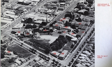
Image, Ballarat School of Mines Aerial View with Dates of Buildings, 1976
Aerial photograph of the Ballarat School of Mines, with establishment date for each building. ballarat school of mines, aerial, buildings, former ballarat gaol, mining laboratory, hillman hall, former supreme court, administration building, ballarat technical art school, former wesley church, ballarat girls technical school, ballarat junior technical school, albert street, grant street, lydiard street south, armstrong street south, dana street -
 Federation University Historical Collection
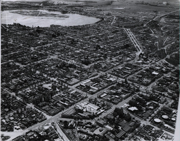
Photograph - Photograph - Black and White, Aerial photograph of Ballarat, including the Ballarat School of Mines Campus, c1960
Four black and white aerial photograph of Ballarat, including the Ballarat School of Mines Campus, former Ballarat Gaol, Lake Wendouree, Ballarat Gasometers, M.B. John Valves (Lydiard Street)ballarat, aerial, ballarat school of mines, ballarat gaol, balllarat brewery, lake wendouree, wendouree -
 Federation University Historical Collection
Photograph - Photograph - Black and White, Aerial View of Federation University SMB Campus, c1967
This photograph was taken around the time that the Ballarat School of Mines obtained the Former Ballarat Gaol site and the Ballarat Brewery site.Black and white photograph showing an aerial View of Federation University SMB Campus. The image shows the former Ballarat Gaol (now demolished), Ballarat Brewery, (now demolished) and White Flat Oval.ballarat school of mines, ballarat gaol, ballarat brewery, white flat, ballarat townscape, smb campus, ballarat school of mines campus, lydiard street, aerial -
 Federation University Historical Collection
Photographs - black and white, Ballarat College of Advanced Education, Aerial views of the Mt Helen campus from the north, not dated
2 black and white aerial photographs .1) Aerial view of Mt Helen campus from the north .2) Aerial view from the northmount helen campus, mount helen campus aerial, student residences -
 Ringwood and District Historical Society
Photograph, Aerial view of Park Orchards and Ringwood - c.1960
Catalogue card reads, "Aerial view of Ringwood". -
 Ringwood and District Historical Society
Photograph, Aerial photograph of Ringwood - 1962
Aerial photographWritten on backing sheet, 'Ringwood 1962'. -
 Kew Historical Society Inc
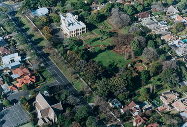
Photograph - Aerial Photograph, Aerial Photograph of Willsmere, circa 1980, c. 1980
This aerial photograph shows the Kew Cottages, and doctors/clergy residences on the north side of Wills Street, before the State Government sold the land for residential development. The doctors residences in Wills street were made of 'Glen Iris' Olympic Bricks. According to neighbours of the time most of the buildings were demolished overnight in the 1980s.Aerial photograph of Willsmere and the Kew Cottages bounded by the Boulevard, the Chandler Highway, Princess Street and Fellows Street. The roundabout at the intersection of Princess Street, Wills Street, and Eglinton Street is at the top left. The Eastern Freeway is at the lower edge of the photograph.kew cottages, eastern freeway, willsmere, yarra river, aerial photographs -- kew (vic), kew boulevard, willsmere mental hospital, kew mental hospital, kew childrens cottages -
 Bayside Gallery - Bayside City Council Art & Heritage Collection
Photograph - type C photograph, Newmark Aerial Photography, Kamesburgh, North Road, Brighton, 1996
kamesburgh, north road, brighton, historic house, aerial, photograph, newmark aerial photography, anzac hostel, william kerr thomson, lloyd tayler, italianate, streets -
 Bayside Gallery - Bayside City Council Art & Heritage Collection
Photograph - type C photograph, Newmark Aerial Photography, Billilla, Halifax Street, Brighton, 1996
brighton, historic house, aerial, photograph, newmark aerial photography, streets, billilla, weatherly, william weatherly, smith and johnson, walter richmond butler, halifax street -
 Federation University Historical Collection
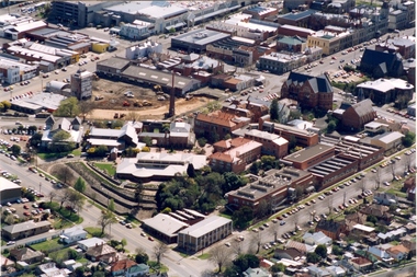
Photograph - Photograph - Colour, Aerial Photograph of the Ballarat School of Mines Campus, c1995
Colour aerial photograph of the Ballarat School of Mines campus. Albert street is shown on the lower right side and Grant Stret on the left. The M.B. John Building is present along Albert Street, the Ballarat Brewery has been demolished in preparation for the building of the Brewery Building. ballarat school of mines, aerial, m.b. john building, e.j. tippett library, corbould hall, brewery building, brew tower, brewery chimney, ballarat school of mines creche -
Ringwood and District Historical Society
Photograph, Aerial photograph of Ringwood, c.1975
Framed aerial photograph of RingwoodVIC3016-75 -
 Ringwood and District Historical Society
Photograph, Aerial view of Ringwood -1972
Black and white aerial photographSimilar photograph -Reg 926 located in NWD 02-09-07 - Item no G0033 -
 Stawell Historical Society Inc
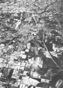
Photograph - Slides, Ian McCann, Aerial View 1976, 1976 - 1984
Aerial Colour Photograph of Stawell -
Federation University Historical Collection
Photograph - Photograph - Black and White, N.L. Harvey & Sons Photographers, Ballarat School of Mines Aerial View
The Ballarat School of Mines Campus is a campus of Federation University Australia.Aerial view of the Ballarat School of Mines campus from the Grant Stret/Eyre Street corner. The photograph was taken after the demolition of the gaol and before the E.J. Tippett Library and Hillman Recreation Reserve were built. The Ballarat Girls' Technical School is present in Grant Street, and in sthe Ballarat SChool of Mines Mining Laboratory in Albert Street. The Ballarat Brewery (then Carton and United Breweries) is present in Lydiard Street South.aerial, ballarat school of mines, ballarat gaol, ballarat school of mines tennis court, grant street, ballarat girls' junior technical school -
Federation University Historical Collection
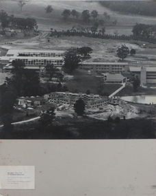
Photograph, Mount Helen Campus Aerial Views, 10/1983
Aerial Photos of the Mount Helen Campusbuildings, mount helen campus, aerials -
Federation University Historical Collection
Photograph, Mount Helen Campus Aerial Views, 1984-1988
Aerial Photos of the Mount Helen Campusbuildings, mount helen campus, aerials -
 Ringwood and District Historical Society
Photograph, Aerial photograph of Ringwood - 1972
Black and white aerial photograph of Ringwood.Written on backing sheet, "Ringwood 1972". -
University of Melbourne, Burnley Campus Archives
Plan - Plan, aerial photograph, Works Plan Scale 1:2000 [Aerial photograph of quarry]
In pencil on back of photograph: Lilydale Quarry Grid & a photolilydale, quarry -
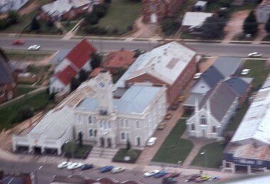 Stawell Historical Society Inc
Slide, Ian McCann, Aerial View of Town Hall
Aerial View of Town and nearby buildingsbuildings, town hall -
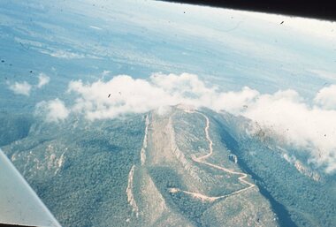 Stawell Historical Society Inc
Slide, Ian McCann, Aerial View of the Grampians, 1960's
Aerial View of the Grampians though cloudsgrampians -
 Bayside Gallery - Bayside City Council Art & Heritage Collection
Photograph - type C photograph, Newmark Aerial Photography, Brighton Town Hall, Wilson Street, Brighton, 1996
brighton, aerial, photograph, newmark aerial photography, streets, brighton town hall, brighton library, brighton court house, court house, library, gardens, wilson street, carpenter street, boxshall street, khyatt's hotel, council chambers, brighton police station -
Tatura Irrigation & Wartime Camps Museum
Photograph, Central Planning Office, Camp 2 aerial, 1989
Black and white aerial photo of camp 2on the back: camp 2 W/c 0065 Vic 82/.9032 Max 1989 Central Planning Office Treasury Place Melbourne -
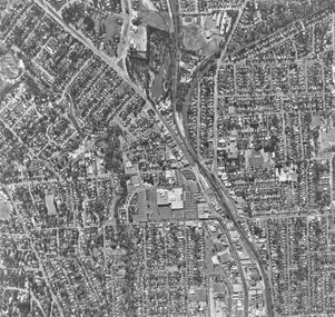
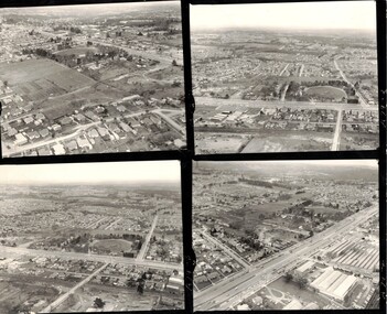 Whitehorse Historical Society Inc.
Photograph, Mitcham aerial photograph in the 1960's
Four black and white aerial photographs of Mitcham.mitcham township, aerial photographs -
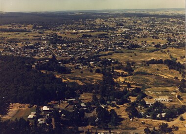 Brown Hill Progress Association Inc.
Photograph - Colour, Aerial Photograph of Brown Hill, Victoria
Aerial photograph of Brown Hill near Ballarat.brown hill, aerial photograph -
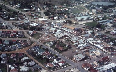
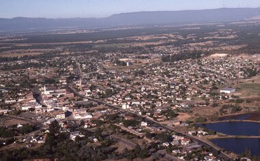 Stawell Historical Society Inc
Slide, Ian McCann, Aerial View of Stawell
Aerial View of Stawell looking towards the Grampiansstawell -
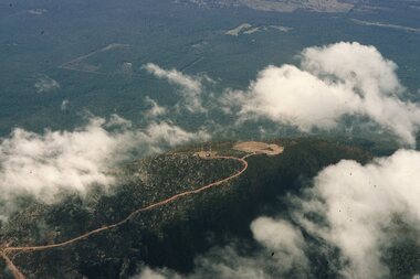 Stawell Historical Society Inc
Slide, Ian McCann, Aerial View of Mt Willaim through Cloud, 1960's
Aerial View of Mt William through Cloudgrampians, mt william