Showing 1124 items matching county%20of%20bourke
-
 Eltham District Historical Society Inc
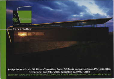
Postcard - Photograph, Evelyn County Estate, Yarra Valley, c.2009
The Evelyn Country Estate, Cellar Door and Black Paddock restaurant and Tony Smibert Gallery opened on 26 April 2001 and officially opened on 18 May 2001 by Roger and Robyn Male - KGC Winter 2001evelyn county estate, kangaroo ground, postcard, yarra valley, restaurant -
 Eltham District Historical Society Inc
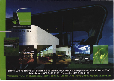
Postcard - Photograph, Evelyn County Estate, Yarra Valley, c.2009
The Evelyn Country Estate, Cellar Door and Black Paddock restaurant and Tony Smibert Gallery opened on 26 April 2001 and officially opened on 18 May 2001 by Roger and Robyn Male - KGC Winter 2001evelyn county estate, kangaroo ground, postcard, yarra valley, restaurant -
 Warrnambool and District Historical Society Inc.
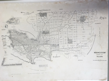
Document: Map, Map Wangoom County of Villiers, 1955
This map contains the names, acreage details and dates of the original property owners of the Parish of Wangoom (County of Villiers), excluding the township of Warrnambool. It also has details of the Crown Lands adjoining the Merri and Hopkins Rivers. This is a most important map as it has details on the original property owners. It is a most valuable research tool and is one of our most-used maps.This is a map, printed in black and white and mounted on cardboard. Where there was intensive land ownership the details have been reproduced in larger print on the margins of the map. There are scuff and dirt marks on the map but it is otherwise in good condition.‘Wangoom, County of Villiers’wangoom, warrnambool, county of villiers -
 Flagstaff Hill Maritime Museum and Village
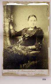
Photograph, late 1800's
Miss Eva Carmichael is one of two survivors of the Loch Ard shipwreck.. Loch Ard was bound for Melbourne in 1878 loaded with passengers and cargo when it ran into a rocky reef at the base of Mutton Bird Island, near Port Campbell. Of the 54 crew members and passengers on board, only two survived: an apprentice, Tom Pearce and a young woman passenger, Eva Carmichael, who lost all of her family in the tragedy. The wreck of Loch Ard still lies at the base of Mutton Bird Island and much of the cargo has been salvaged. Some was washed up into what is now known as Loch Ard Gorge following the shipwreck. Cargo and artefacts have also been illegally salvaged over many years before protective legislation was introduced. The photograph is significant for its association with the wreck of the Loch Ard. This wreck has been protected as a Historic Shipwreck since 11 March 1982, under the Commonwealth Historic Shipwrecks Act (1976) Flagstaff Hill’s collection of artefacts from Loch Ard is significant for being one of the largest collections of artefacts from this shipwreck in Victoria. It is significant for its association with the shipwreck, which is on the Victorian Heritage Register. The collection is significant because of the relationship between the objects, as together they have a high potential to interpret the story of the Loch Ard. The Loch Ard collection is archaeologically significant as the remains of a large international passenger and cargo ship. The Loch Ard collection is historically significant for representing aspects of Victoria’s shipping history and its potential to interpret sub-theme 1.5 of Victoria’s Framework of Historical Themes (living with natural processes). The collection is also historically significant for its association with the Loch Ard, which was one of the worst and best known shipwrecks in Victoria’s history. The Loch Ard collection meets the following criteria for assessment: Criterion A: Importance to the course, or pattern, of Victoria’s cultural history. Criterion B: Possession of uncommon, rare or endangered aspects of Victoria’s cultural history. Criterion C: Potential to yield information that will contribute to an understanding of Victoria’s cultural history. Photograph of Miss Eva Carmichael sitting on a chair holding a curtain. Text below photograph is partly unreadable but gives the name of the photographic studio. A printed on the back "County of Gloucester Studio Cheltenham" with the address and other informaion.Reverse has crest that includes “PRIZE MEDALIST PARIS EXHIBIT’N 1867” Printed text “No. …………” “COUNTY OF GLOUCESTER STUDIO / 20a / PROMENADE VILLAS / CHELTENHAM” and “Autotype Prints or Permanent Porcelain enlargements can be made from this plate” flagstaff hill, warrnambool, shipwrecked-coast, flagstaff-hill, flagstaff-hill-maritime-museum, maritime-museum, shipwreck-coast, flagstaff-hill-maritime-village, photograph of miss eva carmichael, eva carmichael, loch ard shipwreck, county of gloucester studio -
 Tatura Irrigation & Wartime Camps Museum
Map, Department of Land and Survey, County of Rodney
Early county maps.One original map of County of Rodney and 3 photo copies. Original and one copy in colour. 2 copies in black and white. county of rodney -
Whitehorse Historical Society Inc.
Map, Directory Maps of the County of Bourke, 1892
Directory maps of the County of Bourke, containing all the Parishes ...Directory maps of the County of Bourke, containing all the Parishes ... also a complete map of the Colony of Victoria, showing all the Counties, Parishes, Railways and stations to date, and the Mallee Blocks. Lithographed by G.S.B. Bonney for the Victorian Shire Map Company. Scale: 40 chains to the inch.Directory maps of the County of Bourke, containing all the Parishes ...maps, victoria. county of bourke, t.r.b. morton & son -
 Federation University Historical Collection
Postcard - colour, Enniskerry, County Wicklow, Ireland
A town is surrounded by green fields and trees. A mountain is evident in the backgroundchatham-holmes family collection, enniskerry, wicklow, ireland -
 Federation University Historical Collection
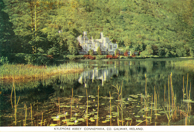
Postcard - Colour, Kylemore Abbey Connemara, County Galway, Ireland
An abbey is surrounded by trees with a lake in the foreground.chatham-holmes family collection, kylemore abbey, connemara, galway, ireland -
 Ballarat and District Irish Association
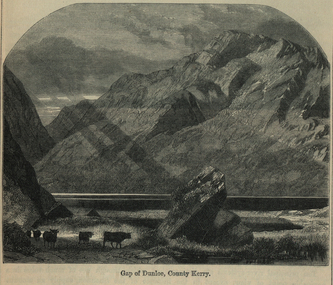
Image, Gap of Dunloe, County Kerry, c1864
The Gap of Dunloe is a narrow mountain pass between Macgillycuddy's Reeks (west) and Purple Mountain (east) in County Kerry, Ireland. It is about 11 km (6.8 mi) from north to south. Within it are five lakes: Coosaun Lough, Black Lake, Cushnavally Lake, Auger Lake, and Black Lough (north to south). These lakes are connected by the River Loe. Between the first two lakes is an old arch bridge called the 'Wishing Bridge' so named because it is said that wishes made while upon it are destined to come true. (http://en.wikipedia.org/wiki/Gap_of_Dunloe)Image of a mountain range in County Kerry, Ireland. Cattle feature in the foreground. ballarat irish, dunloe, gap of dunloe, county kerry -
 Otway Districts Historical Society
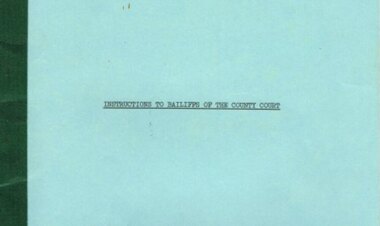
Document, Instructions to Bailiffs of the County Court, 1978, 1 January 1978
Bailiffs are officers of the Court and as such play an important role in the overall administration of justice. This booklet has been prepared as a guide to Bailiffs of the County Court of Victoria in the performance of their duties. The principal functions of the Bailiffs are the issue and service of summonses, and verdicts and judgements given effect by the execution of warrants. In any case where Bailiffs are uncertain or unsure of what to do the Registrar of the Court to which they are attached should be consulted and their directions followed.Document. Instructions to Bailiffs of the County Court. State of Victorian; Melbourne (Vic); 1978. 28 p. Soft cover.victoria; bailiffs; county court; -
 Kew Historical Society Inc
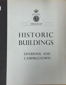
Book, Cumberland County Council, Historic Buildings: Liverpool and Campbelltown, 1963
[Liverpool, N.S.W.] : Cumberland County Council, 1963 54 p. : ill., maps ; 26 cm. non-fictionhistoric buildings -- new south wales -- liverpool., historic buildings -- new south wales -- campbelltown. -
 Ballan Shire Historical Society
Map - Map. Kerrit Bareet, Department of Lands and Survey, Kerrit Bareet. County of Grant, 08/1944
A map of the Kerrit Bareet area within the County of Grant showing properties and names of owners in 1944.Significant to people researching land usage and ownership. Also those researching families in the area at that time.A map of Kerrit Bareet in the County of Grant. Black printing on buff coloured paper. Details roads, rivers, railways, property boundaries and names of property owners and towns and villages. The map is easily readable although there is some physical damage and that and the borders have been reinforced with sellotape. Shows a Scale in Chains and Price 2/.gordon, bungal, kerrit bareet, lal lal, moorarbool river, warrenheip, bungaree, wallace, moorarbool west -
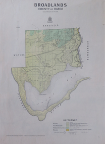 Federation University Historical Collection
Map, Broadlands, County of Dargo, 1887
Plan of Broadlands, County of Dargo, Victoria.broadford, j.g. easton, dargo, geological -
 Federation University Historical Collection
Plan, Ballark: County of Grant, 05/01/1889
A geological plan of Ballark in the County of Grant.moreep, mount wallace, ballark -
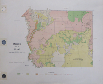
 Ballan Shire Historical Society
Map - Map. Ballark, Department of Lands and Survey, Ballark. County of Grant, 31/08/1915
A map of the Ballark area within the County of Grant showing roads, waterways, property boundaries and property owners in 1915.Significant to people researching land usage and ownership. Also those researching families in the area at that time.A map of Ballark in the County of Grant. Black printing on buff coloured paper. Extra notations by hand and various coloured highlighting of certain features. Details roads, rivers, property boundaries and names of property owners and districts. The map is easily readable although there is some physical damage to the borders and some sellotape residue. Shows a scale in Chains and the number L.6030Various numbers and directional arrows added to map.bungal, borhoneyghurk, bungeeltap, ballark, beremboke, moreep, meredith, morrisons, moorarbool river -
 Ringwood and District Historical Society
Map, Department of Mines, Plan of area applied for under the mining leases regulations in the township of Ringwood between Maroondah Highway and Mt. Dandenong Road. Mining District of Castlemaine, County of Mornington, Parish of Ringwood T Area 58(A) 2 (R)15(P) Acres, Roods, Perches. 1934, 20-Feb-34
Map of the township of Ringwood with subdivisions between Maroondah Highway and Mt. Dandenong Road. the area applied for on lease No.8210 by E.G.Browne.Mining District of Castlemaine, County of Mornington, Parish of Ringwood T Area 58(A) 2 (R)15(P) Acres, Roods, Perches.Buff coloured sheet foolscap with black printing showing map of the township of Ringwood between Maroondah Highway and Mt. Dandenong Road. Mining District of Castlemaine, County of Mornington, Parish of Ringwood T Area 58(A) 2 (R)15(P) Acres, Roods, Perches +Additional Keywords: Browne E.G. -
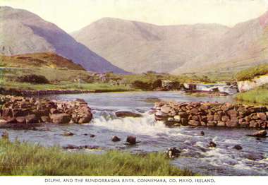 Federation University Historical Collection
Postcard, Delphi, and the Bundorragha River, Connemara, County Mayo, Ireland, 1952
Coloured postcard showing a river and mountains in County Mayo, Ireland. chatham family archive, county mayo, ireland, bundorragha, delphi -
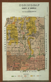 Federation University Historical Collection
Plan - Parish Plan, Corindhap, County of Grenville, 1898
Colour Parish Plan of Corindhap, County of Grenville, and a report on the Parish.corindhap, dereel, warrambine, kuracaruc, commeralghip, rokewood, kuruc-a-ruc, w. elder, william elder, john thornly, robert cullen, davis aitcheson, robert gidney, john elder, w. barnard, anton trende, thomas hill, george hobson, h. reynolds, john collins, ironstone quarry, john jacka, patrick shanahan, murdoch mclennon, kaolinitic clay, kaolin, james holt, mary a. palmer, isaac everett, james mooney, michael cahill, fred benjamin, george hopkins, david houghton, john quarrell, j. camm, james macdonald, john thornley, break of day gully, john wilson, thomas middleton, alexander mcpherson, joseph coldwell, h. brand, pereverance co, puddling mils, mary a. stanbrook, c.w. stanbrook, eliza byrnes, james byrnes, j. maw, wallace douglas, john moffatt -
Federation University Historical Collection
Document, Beaufort County Court Order in Council, 1862-3, 1862-1863
Blue Foolscap printed Government document on the Beaufort County Court.goldfields act, j.h. kay, beaufort, beaufort county court, archibald michie -
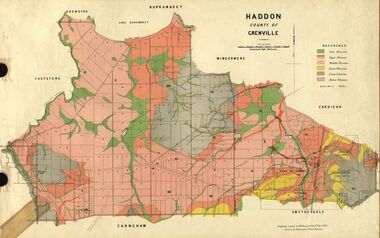 Federation University Historical Collection
Plan, Haddon, County of Grenville, 1887, 1889
Ferdinand Krause taught at the Ballarat School of MinesGeological Map of Haddon in the County of Grenville surveyed by Ferdinand Krause. haddon, grenville, krause, ferdinand krause, cgt, lake burrumbeet, windermere, chepstowe, bailies creek, snake valley lead, nentingbool preemptice right, cardigan state forest, haddon state forest -
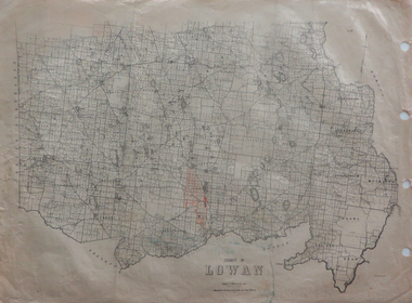 Federation University Historical Collection
Maps, County of Lowan, 1930
Printed maps on paper backed onto linen: .1) County of Lowan .2) Weeahlowan -
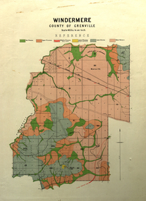 Federation University Historical Collection
Map, Windermere, County of Grenville
Coloured geological map of Windermere, County of Grenville. Scale is 40 chains to 1 inchwindermere, grenville, krause, plan, map -
 Federation University Historical Collection
Postcards - black and white, Souvenir of Enniskerry, County Wicklow, Eire
Black and white photographic postcard showing three images of Enniskerry, County Wicklow, Eirechatham family archive, enniserry, eire, wicklow, powerscoirt, sugarloaf -
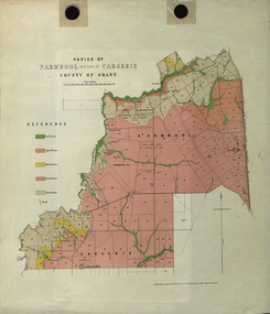 Federation University Historical Collection
Plan - Map, Mines Department, Parish of Narmbool and part of Cargerie, County of Grant, 1892, 06/1992
This map shows the position of the homestead on the Narmbool Pre-emptive Right, volcanic craters, stock reserve, quarry and geological eras,Geological map showing Narmbool and part of Cargerie in the County of Grant in five colours, predominantly pink.narmbool, cargerie, narmbool pre-emptive right, williamson's creek, leigh river, green hill, collyer's hill, volcano, crater, krause, ferdinand krause -
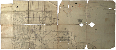 Federation University Historical Collection
Plan, Creswick, County of Talbot
This plan is associated with former Ballarat School of Mines Student Richard Squire (1875-1876). Gift of the Squire Family, 2014 Plan showing allotments in Creswick, County of Talbot. The plan is in a number of pieces with some sections missing.creswick, creswick creek, spring hill, sarah paterson, lehman, mullins, spittle, squire, richard squire -
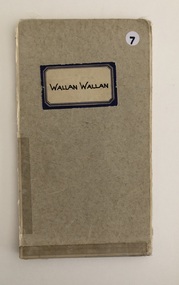 Whittlesea Historical Society Inc.
Map, Department of Crown Lands and Survey, Wallan Wallan, County of Bourke, 1946
1 map, folding, showing parish boundaries and land ownership, Wallan Wallan, County of Bourke.Drawn and reproduced at the Department of Lands and Survey, Melbourne, Victoria. October, 1946. Price 2/-map, wallan wallan, wallan wallan parish map, county of bourke -
 Federation University Historical Collection
Map - Plan, E.J. Dunn, Bungal County of Grant Parish Plan
E.J. Dunn was tje surveyor of this parish plan.Colour geological plan of Bungal in the County of Grant, Victoria. The areas circled in red ar craters.plan, bungal, bungeltap, black horse co. egerton, egerton, mount egerton, sister rose shaft, south learmonth co, kerrit bareet, bungaeeltap, yaloak, eastern moorabool river, corong, bungal station preemptive right, lal lal, western moorabool river, moorabool rover, borhoneychurck, mount egerton battery, bungal creek -
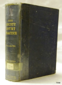 Flagstaff Hill Maritime Museum and Village
Book, The Practice of The County Court
The Practice of The County Court With Notes by P A Jacobs Publisher: George G Harrap & Co Date: 1931Label on spine cover with typed text R.H. 398.42 EBB warrnambool, shipwrecked-coast, flagstaff-hill, flagstaff-hill-maritime-museum, maritime-museum, shipwreck-coast, flagstaff-hill-maritime-village, shipwrecked-artefact, book, the practice of the county court, p a jacobs -
 Flagstaff Hill Maritime Museum and Village
Map - Survey Map, F.F. McGovern, Yangery - County of Villiers, 1884
A surveyor was employed to measure the land designated as Yangery, County of Williers, in the Borough of Warrnambool. The area on the map is similar to the earlier Farnham Survey undertaken by William Rutledge in the 1850's. Warrnambool was a Borough between 1863-1883. Coutours, waterways, sea and other significant points are shown. The distances are accurately measured. This survey map was used for planning future land sales, recreation areas and roads. WILLIAM RUTLEDGE (1806-1876) William Rutledge surveyed the land known as Farnham in southwest Victoria in 1843. His tenants made him a profitable business from working the land there. In 1863 Rutledge moved from nearby Port Fairy to Farnham and became very successful in breeding sheep, which he imported from J.R. Kirkham of Lincolnshire, England. He also bred horses on his land. The survey map of Yangery is important for its connection with renowned surveyor William Rutledge. The map shows the growth of landholders in the district when compared to the original Rutledge survey of the 1850's.Survey map of Yangery, titled "Yangery - County of Villiers". Printed on white paper, mounted on brown paper. c. 1863-1876. Comments printed on the Map include; Special Survey by William Rutledge, Photo-lithographed at the Department of Lands and Survey, Melbourne by W.J. Burson, Price 1/- [one shilling]. Scale is in Chains. Map has boundaries of Koroit Borough, Meerai, Purnim, Wangoom, Borough of Warrnambool, Mentions the Proposal of Tower HIll for Public Recreation. The map names the owners of the land at that time. Hand written pencil marks and figures and "Sauls fence" drawn on map. Hand written pencil markes and figures and "Sauls fence" drawn onto map. "For Department Use only". "Scale: 8 chains to 1 inch" flagstaff hill, warrnambool, shipwrecked-coast, flagstaff-hill, flagstaff-hill-maritime-museum, maritime-museum, shipwreck-coast, flagstaff-hill-maritime-village, county of villiers map, yangery district, w.j. burson, borough of warrnambool, koroit, purnim, meerai, wangoom, proposal of tower hill for public recreation, special survey by william rutledge, william rutledge, farnham, lincolnshire sheep, clydesdale -
 Kew Historical Society Inc
Plan - Framed Subdivision Plan (copy), F Price, Plan of Mr William Derrick's Land, Kew being Subdivision of Part of Section 86, Parish of Boroondara, County of Bourke, 1872
William Derrick was an early landowner in Kew, and with James Venn Morgan and James Dannock the purchaser of the parcel of land bounded by Cotham Road, High Street and Mary Street. Derrick Street in Kew is named after him.Map mounted under perspex. ‘Plan of Mr Willia Derrick's Land, Kew being Subdivision of Part of Section 86, Parish of Boroondara, County of Bourke’. This is a copy of the plan held in the State Library of Victoria.kew subdivision plan, john derrick, subdivision plans -- kew (vic.)