Showing 909 items matching navigation
-
 Flagstaff Hill Maritime Museum and Village
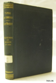
Book - Papers and Addresses, Thomas Brassey, author, Papers and Addresses Mercantile Marine and Navigation from 1871 to 1894, 1894
The papers in this work are focused on Thomas Brassey (1836-1918) who was born and educated in England. They include the period 1871-1894, before he accepted the position of Governor of Victori, Australia, in 1895. During that time, he'd won a seat in parliament, which he held for 18 years, and for periods was a civil lord and parliamentary secretary for the Admiralty. He was passionate about the sea and addressed his naval and maritime concerns in public lectures, letters, pamphlets and books. He was also for a time lord-in-waiting to Queen Victoria and president of the Institute of Naval Architects. This book is from Flagstaff Hill's ‘Pattison Collection’, a collection of books and records that was originally owned by the Warrnambool Mechanics’ Institute, which was founded in Warrnambool in 1853. It was edited by Captain S. Eardley-Wilmot, and published by Longmans, Green and Co. of London. The Longmans, Green and Co. was originally founded in 1724 in London by Thomas Longman under the name Longman. In August of that year, he bought the two shops and goods of William Taylor and set up his publishing house there at 39 Paternoster Row. The shops were called Black Swan and Ship, and it is said that the 'ship' sign was the inspiration for Longman's Logo. After many changes of name and management, the firm was incorporated in 1926 as Longmans, Green & Co. Pty Ltd. The firm was acquired by Pearson in 1968 and was known as Pearson Longman or Pearson PLC. Interestingly, the logo in some books, such as “Steam Turbines 2nd edition, published in 1922” has the year “1724” but the logo in books such as “Advanced Agriculture, published in 1894” has the year “1726” in the logo.The book is significant for publishing historical papers and addresses by Lord Thomas Brassey, former Governor of Victoria before Australia’s Federation. Brassey was passionate about naval and maritime matters in public and government capacities. The work is important for its connection with the publisher Longmans, Green and Co., of London, a firm that has been established for over two centuries, renowned for publishing encyclopedias, dictionaries, books on English grammar, textbooks, poetry, reference books, novels, magazines and more. The book has additional importance for its connection to the Pattison Collection, which, along with other items at Flagstaff Hill Maritime Village, was originally part of the Warrnambool Mechanics' Institutes’ Collection. The Warrnambool Mechanics’ Institute book collection has historical and social significance for its strong association with the Mechanics Institute movement and its important role in people's intellectual, cultural and social development throughout the latter part of the nineteenth century and the early twentieth century. The collection of books is a rare example of an early lending library and its significance is enhanced by the survival of an original collection of many volumes. The Warrnambool Mechanics' Institute’s publication collection is of both local and state significance.Papers and Addresses Mercantile Marine and Navigation from 1871 to 1894 Author: Lord Brassey Arranged and Edited Captain S. Eardley-Wilmot Publisher: Longmans Green and Co. Date: 1894 One of a set of six books. Part of the Pattison Collection. Green hardback cover with embossed gold text and label on spine. Inscriptions include a label on the spine, stickers and black handwriting.Label "PAT 359 BRA" Sticker "Warrnambool Mechanics Institute and Free Library" Sticker "Corangamite Regional Library Service" Handwritten text on Fly "(crossed out) G 469 231" and "M" "2397"flagstaff hill, flagstaff hill maritime museum and village, warrnambool, maritime museum, maritime village, great ocean road, shipwreck coast, pattison collection, ralph eric pattison, warrnambool mechanics’ institute, mechanics’ institute library, warrnambool library, free library, corangamite regional library service, longmans green and co., thomas longman, paternoster row london, thomas brassey (1836-1918), lord brassey, earl brassey, governor of victoria, politician, civil lord of the admiralty, publicist, naval affairs, maritime affairs, public lectures, parliamentary addresses, author, lord-in-waiting to queen victoria, president of the institute of naval architects, captain s. eardley-wilmot, papers and addresses, mercantile marine and navigation, 1871-1894 -
 Greensborough Historical Society
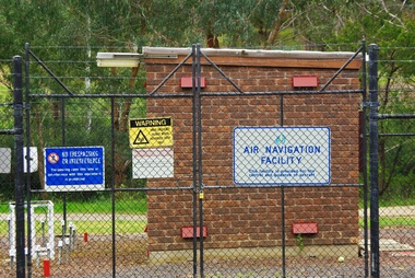
Photograph - Digital Image, Air Navigation Facility, Montmorency, 2018, 1930s
Air Navigation Facility, Palara Court Montmorency, is made up of a tower and brick building surrounded by wire fences. It is sited in parkland at the end of Palara Court close to the Plenty River Trail. Warning signs are placed on the fences, including: "This facility is provided for the control and guidance of aircraft".Digital copy of colour photographair navigation facility, air control, palara court montmorency -
 Greensborough Historical Society
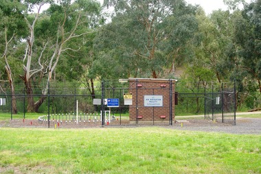
Photograph - Digital Image, Marilyn Smith, Air Navigation Facility, Montmorency, 2018. Long view, 04/12/2018
Air Navigation Facility, Palara Court Montmorency, is made up of a tower and brick building surrounded by wire fences. It is sited in parkland at the end of Palara Court close to the Plenty River Trail. Warning signs are placed on the fences, including: "This facility is provided for the control and guidance of aircraft".Digital copy of colour photographsair navigation facility, air control, palara court montmorency -
 Greensborough Historical Society
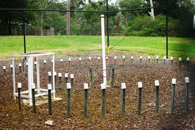
Photograph - Digital Image, Marilyn Smith, Air Navigation Facility, Montmorency, 2018. Close up, 04/12/2018
Air Navigation Facility, Palara Court Montmorency, is made up of a tower and brick building surrounded by wire fences. It is sited in parkland at the end of Palara Court close to the Plenty River Trail. Warning signs are placed on the fences, including: "This facility is provided for the control and guidance of aircraft".Digital copy of colour photographair navigation facility, air control, palara court montmorency -
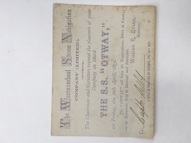 Warrnambool and District Historical Society Inc.
Ticket, The Warrnambool Steam Navigation Co Ltd, 1873
This card relates to an excursion aboard “The SS Otway leaving the Warrnambool Jetty at 8 am April 18th 1873 to go to Belfast and Portland courtesy of the Warrnambool Steam Navigation Company Limited which was originally called the Warrnambool Steam Packet Company. The Otway was the second steamer purchased by the company. It had a number of ships which traded along the coast including, the Nelson, Julia Percy, Otway and The Edina. The Edina was originally owned by Stephen Henty who was operating it from Portland but he sold it to the new company for £8500. Henty then withdrew from the Belfast and Warrnambool trade for a time but it proved to be a competitive business. The name was changed again in 1878 to The Western Steam Navigation Company and the SS Otway was put up for sale. This card relates to one of the first trips, if not the first trip, taken by the SS Otway Shipping was a major part of the history of Warrnambool and this ticket is a link to one of the earliest passenger and freight services which operated along the coast.Small cream card with light purple text with company name at the top. Capital letters done in scroll lettering. There are feint markings in the centre of the back which appear to have been rubbed off.Signed by Captn Selby. William R Evans manager. 18th April 1873.warrnambool steam navigation company, edina, stephen henty, s s otway -
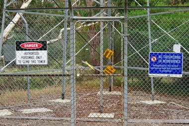 Greensborough Historical Society
Photograph - Digital Image, Marilyn Smith, Air Navigation Facility, Montmorency, 2018. Signs at tower, 04/12/2018
Air Navigation Facility, Palara Court Montmorency, is made up of a tower and brick building surrounded by wire fences. It is sited in parkland at the end of Palara Court close to the Plenty River Trail. Warning signs are placed on the fences, including: "This facility is provided for the control and guidance of aircraft". This photograph shows signs at tower.Digital copy of colour photographair navigation facility, air control, palara court montmorency -
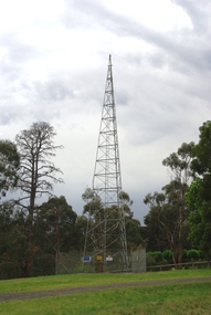 Greensborough Historical Society
Photograph - Digital Image, Marilyn Smith, Air Navigation Facility, Montmorency, 2018. Tower, 04/12/2018
Air Navigation Facility, Palara Court Montmorency, is made up of a tower and brick building surrounded by wire fences. It is sited in parkland at the end of Palara Court close to the Plenty River Trail. Warning signs are placed on the fences, including: "This facility is provided for the control and guidance of aircraft". This photograph shows the tower on the site.Digital copy of colour photographsair navigation facility, air control, palara court montmorency -
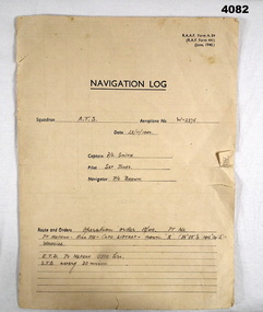 Bendigo Military Museum
Document - NAVIGATION DOCUMENT, Navigation Log, 22.11.1942
Navigation Log for flight by A.T.S in Aeroplane W - 2275 operating under order No 18/40. Details filled in on form RAAF A.84. Form filled in by F/L Smith, Sgt Jones, P/O Jones. Part of the Frederick Gardner DFC RAAF No 410533 collection. Refer Cat No 3536P for his service details.Four page Proforma printed in black ink, handwritten details in pencil on pages 1,2,3.The hand written information pages 1,2,3, details a flight from Pt Nepean to Woodside, weather, wind speed and observation points noted.training flight, raaf, w - 2275 -
 Bendigo Military Museum
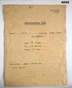
Document - NAVIGATION DOCUMENT, Navigation Log, 6.2.1942
Navigation Log for Training Flights by A.T.S in Aeroplane W1234 (Anson), details filled in on RAAF form A.84. Filled by F/L McBoast, P/O Prune, F/O Knutts. (These are fictitious names to obviously give an example) Part of the Frederick Gardner Davey DFC No 410533 RAAF Collection. refer Cat No 3536P for his service details.Four page proforma printed in black ink, handwritten details on pages 1,2,3,, page four no handwritten details.Hand written in format on pages 1 - 3 in pencil detailing flight flight from Koroit to Smithton (Tasmania), weather, wind speed and observation points.navigation log, training flights, raaf -
 Shepparton RSL Sub Branch
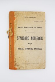
Book, Royal Australian Air Force, Standard Notebook for Initial Training Schools: Air Navigation, August 1942
This notebook contains information on air navigation and electrical science. It was issued to Roy Eliason (449852), a Shepparton local who enlisted in 1944 and served as a Leading Aircraftman with the 2nd Operational Training Unit Mildura. Contents include: Appendix I: Law, Discipline, Administration and Organisation, Hygiene and Sanitation, Notes on Meteorology, Definitions, The principles of flight, Airframes, Engine; Appendix II: Mathematics problems for revision.This notebook has significant research potential, as it bears the service number of the owner: Roy Eliason. Roy Eliason's service history is well documented in the National Archives of Australia and this book provides an insight into a period of his service. Notebooks such as this were presumably issued to new recruits in the early stages of their service. Though this copy is in fair condition with several signs of wear, these signs may in fact increase the significance of the item, demonstrating the frequent use of this item in the hands of a new recruit to the Royal Australian Air Force. Series of pages bound via twine passed through four holes along left side. Front and back cover are card with orange vinyl/fabric strip and paper cover bearing title text. Orange pages throughout mark sections. Book printed throughout.Inscribed on front cover: "449852/AC2 ELIASON R/B/2". Inscribed on interior "449852/ELIASON. R./B/2". air navigation, training, royal australian air force, raaf, eliason, world war ii, wwii, second world war -
 Wangaratta RSL Sub Branch
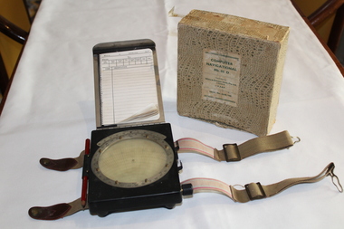
Instrument - Aircraft Navigation Computer
The navigational computer was a circular slide rule used for calculating height and air speed corrections when flying an aircraft. The front cover lifts to reveal a further calculator used to solve vector triangles and plot course alterations. The device was intended to be strapped to a pilot's leg. The instrument was made by White and Gillespie (Melbourne) Pty Ltd c 1940 for the RAAF and used during WW2.Black metal box with silver metal flap top cover affixed with rotating circular rule . Two adjustable belts are affixed to the base of black box. A small spiral bound note book is contained beneath the flap top. RAAF Computer Navigational system MK. III. D. Serial No WG 2833navigation, raaf, computer, aircraft, ww2, 1940 -
 Moorabbin Air Museum
Manual (Item) - Private Pilot Navigation Volume 1 , Basic Navigation Theory , Radio Navigation Aids
-
 Bendigo Military Museum
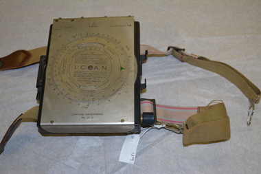
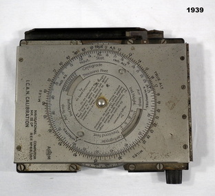
Equipment - COMPUTER, c.1939
Item used by Navigators or Pilots of small aircraft. Belonged to Maxwell Lennox MATHESON 418447 RAAF. Refer Cat No1959 for his service history.NAVIGATIONAL Computer Mark III.D, metal - bakelite, construction rectangular box shape, top lid hinges open. Top lid has a circular adjustment. Inside has another circular adjustment. Centre is a graph in red which winds by a dial on side. Inside top lid hand written in black are items of Navigation."NAVIGATIONAL Computer MKIID REF No 68/180 ICAN CALIBRATION"electrical technology, appliances & accessories, navigational -
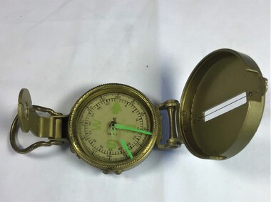 Queenscliffe Maritime Museum
Instrument - Navigational Compass
A round hand held navigational engineer compassEngineer Compassnavigation, compass -
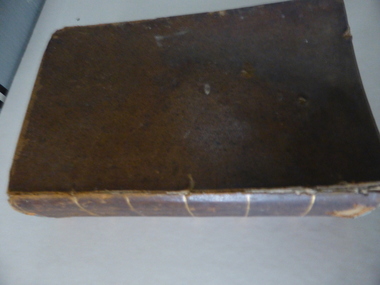 Warrnambool and District Historical Society Inc.
Book, A Complete Epitome of Practical Navigation - J W Norie, 1848
This book is a 19th Century treatise on aids to navigation. It belonged to John Cowtan who held land near the Cassady's Bridge area in Caramut Road today (he was related to the Cassady family) and who is mainly important in the history of Port Fairy. Captain John Cowtan was a ship's master for John Griffiths and a Launceston entrepreneur and ship owner between 1839 and 1844. In 1847 he went into partnership with John Bland, establishing a merchant's business with riverside buildings at the Port Fairy wharf. He left Port Fairy in the 1860s. The date of John Cowtan's signature in this book is 1849 (certainly a very early one in our history) and inside the front cover he has written notes about the local weather, mainly as it affected sailing conditions in late 1849 and early 1850. These notes are of great historical interestThis book is of great interest because it belonged to a Port Fairy historical figure and because of the hand written weather notes inside the front cover. This is a hard covered,leather bound book of 680 pages. It contains printed text, illustrations, tables, maps and sketches.One page is torn Some pages are stained. . J Cowtan 1849john cowtan, port fairy -
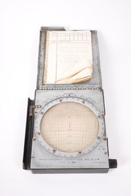 Dandenong/Cranbourne RSL Sub Branch
Equipment - Dalton Air Navigation Computer, Unknown
Grey metal boxed navigational computer, hinged lid with notebook attachedUnder metal lid inscribed 'Navigational Computer MK. 111 D. REF. 6B/180'16 On note pad Dalton 'Air Navigation Computer, as used by Flt Lt F.P. Field Aus 4o1817 1941,46. On operations over Atlantic Ocean on 'short' Sunderland 4 engine flying boats. -
Moorabbin Air Museum
Manual (Item) - Private Pilot Licence - Navigation Volume 2 ,Flight Planning , En Route Navigation
-
Moorabbin Air Museum
Manual (Item) - Royal Air Force -- Manual - Air Navigation - Vol.1 Theory & Practice of Air Navigation
Royal Air Force -
Moorabbin Air Museum
Manual (item) - Air Navigation vol 5 Radio Navigation Aids - RAF Air Ministry Oct 1947
-
Moorabbin Air Museum
Manual (item) - Air Navigation vol 5 Radio Navigation Aids - RAF Air Ministry Oct 1947
-
Moorabbin Air Museum
Manual (Item) - Air Navigation - a introduction to Practical Navigation
-
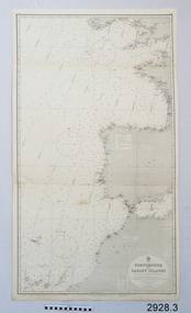 Flagstaff Hill Maritime Museum and Village
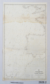
Document - Navigation Chart, Portsmouth to Canary Islands, Ca. 1928
This is an Official British Admiralty Navigation Chart, one of a set of 65 charts donated together with a wooden chart case. It was published and printed in London in 1928 by the British Admiralty. Navigation charts are drawn by professional hydrographers and describe the geography of land and water, enabling a water based navigator on board vessels such as ships to safely negotiate between ports locally and around the world. They are drawn to a particular standard with common symbols noting landmarks. The charts are used in conjunction with other navigational instruments and tools to calculate the vessel’s exact location and a safe route to its destination.The set of charts and their chart are of significance as examples of equipment and documents used to navigate the oceans of the world, particularly to Australia. Migration to Australia is an important part of this country's history.British Admiralty Navigation Chart - Portsmouth to Canary Islands - printed on rectangular white paper. Published in London by the British Admiralty in 1928.warrnambool, shipwreck coast, flagstaff hill, flagstaff hill maritime museum, flagstaff hill maritime village, chart, map, navigate, navigation, location, vessel, 1928, british admiralty, hydrographer, geography, admiralty chart, portsmouth, canary islands -
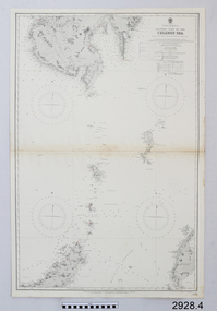 Flagstaff Hill Maritime Museum and Village
Document - Navigation Chart, Eastern Part of the Celebes Sea, Ca. 1928
This is an Official British Admiralty Navigation Chart, one of a set of 65 charts donated together with a wooden chart case. It was published and printed in London in 1928 by the British Admiralty. Navigation charts are drawn by professional hydrographers and describe the geography of land and water, enabling a water based navigator on board vessels such as ships to safely negotiate between ports locally and around the world. They are drawn to a particular standard with common symbols noting landmarks. The charts are used in conjunction with other navigational instruments and tools to calculate the vessel’s exact location and a safe route to its destination.The set of charts and their chart are of significance as examples of equipment and documents used to navigate the oceans of the world, particularly to Australia. Migration to Australia is an important part of this country's history.British Admiralty Navigation Chart - Eastern Part of the Celebes Sea - printed on rectangular white paper. Published in London by the British Admiralty in 1928.warrnambool, shipwreck coast, flagstaff hill, flagstaff hill maritime museum, flagstaff hill maritime village, chart, map, navigate, navigation, location, vessel, 1928, british admiralty, hydrographer, geography, admiralty chart, celebes sea -
 Flagstaff Hill Maritime Museum and Village
Document - Navigation Chart, Portsmouth to Canary Islands, CA. 1928
Navigation charts are drawn by professional hydrographers and describe the geography of land and water, enabling a water based navigator on board vessels such as ships to safely negotiate between ports locally and around the world. They are drawn to a particular standard with common symbols noting landmarks. The charts are used in conjunction with other navigational instruments and tools to calculate the vessel’s exact location and a safe route to its destination.The set of charts and their chart are of significance as examples of equipment and documents used to navigate the oceans of the world, particularly to Australia. Migration to Australia is an important part of this country's history.British Admiralty Navigation Chart - Portsmouth to Canary Islands - printed on rectangular white paper. Published in London by the British Admiralty in 1928.warrnambool, shipwreck coast, flagstaff hill, flagstaff hill maritime museum, flagstaff hill maritime village, chart, map, navigate, navigation, location, vessel, 1928, british admiralty, hydrographer, geography, admiralty chart, portsmouth, canary islands -
 Dandenong/Cranbourne RSL Sub Branch
Equipment - RAAF Navigational Computer, White and Gillespie (Melb.) Pty Ltd, Possibly 1940
WWII Historical significanceRAAF Navigational computer MK111 D used in WW11 in aircraft for plotting direction and wind speed with original box.Identification number G6B/145. Serial No WG/2677*. Contains original pencil from 1940 and navigational notebook. -
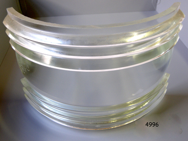
 Flagstaff Hill Maritime Museum and Village
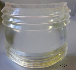
Functional object - Fresnel Glass Lens, Early 20th century
A Fresnel lens is a type of composite compact lens developed by the French physicist Augustin-Jean Fresnel (1788–1827) for use primarily in lighthouses. Made from high-quality glass Fresnel lenses were used originally in lighthouses and later for many other applications They were later being used for automobile headlamps, brake, parking, and turn signal lenses, and many other applications. Fresnel lenses used in lighthouses were considered state of the art from the late 19th through to the middle of the 20th century. The subject item is a Fresnel replacement lens used in a ships navigation light. For lighthouses, these lenses have now been replaced with much less expensive and more durable aerobeacons, which themselves often contain plastic Fresnel lenses. The lens design allows the construction of lenses of large aperture and short focal length without the mass and volume of material that would be required by a lens of conventional design. A Fresnel lens can be made much thinner than a comparable conventional lens, in some cases taking the form of a flat sheet. The simpler dioptric (purely refractive) form of the lens was first proposed by Count Buffon and independently reinvented by Fresnel. The catadioptric form of the lens, entirely invented by Fresnel, has outer elements that use total internal reflection as well as refraction; it can capture more oblique light from a light source making the light visible from greater distances.The subject item at this time cannot be associated with a historical event, person or place, provenance is unknown, the item is a replacement for a ships navigation light and it is believed to have been produced before 1950.Fresnel glass replacement lens for a navigation lamp of a ship. None warrnambool, flagstaff-hill, flagstaff-hill-maritime-museum, maritime-museum, shipwreck-coast, flagstaff-hill-maritime-village, fresnel lens, maritime light, ships navigation light, augustin-jean fresnel, lighthouse lenses, lighthouse, navigation, warning light -
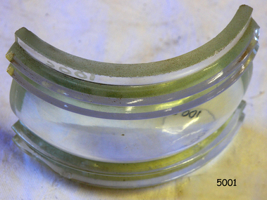
 Flagstaff Hill Maritime Museum and Village
Functional object - Fresnel Glass Lens, Early 20th century
A Fresnel lens is a type of composite compact lens developed by the French physicist Augustin-Jean Fresnel (1788–1827) for use primarily in lighthouses. Made from high-quality glass Fresnel lenses were used originally in lighthouses and later for many other applications They were later being used for automobile headlamps, brake, parking, and turn signal lenses, and many other applications. Fresnel lenses used in lighthouses were considered state of the art from the late 19th through to the middle of the 20th century. The subject item is a Fresnel replacement lens used in a ships navigation light. For lighthouses, these lenses have now been replaced with much less expensive and more durable aerobeacons, which themselves often contain plastic Fresnel lenses. The lens design allows the construction of lenses of large aperture and short focal length without the mass and volume of material that would be required by a lens of conventional design. A Fresnel lens can be made much thinner than a comparable conventional lens, in some cases taking the form of a flat sheet. The simpler dioptric (purely refractive) form of the lens was first proposed by Count Buffon and independently reinvented by Fresnel. The catadioptric form of the lens, entirely invented by Fresnel, has outer elements that use total internal reflection as well as refraction; it can capture more oblique light from a light source making the light visible from greater distances.The subject item at this time cannot be associated with a historical event, person or place, provenance is unknown, the item is a replacement for a ships navigation light and it is believed to have been produced before 1950.Fresnel glass lens for a ships masthead navigation lamp. Nonewarrnambool, flagstaff-hill, flagstaff-hill-maritime-museum, maritime-museum, shipwreck-coast, flagstaff-hill-maritime-village, fresnel lens, maritime light, ships navigation light, augustin-jean fresnel, lighthouse lenses, lighthouse, navigation, warning light -
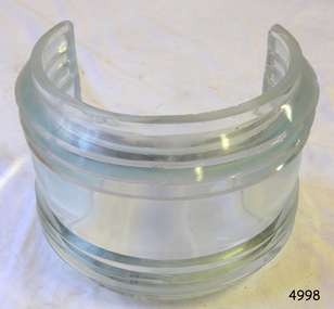
 Flagstaff Hill Maritime Museum and Village
Functional object - Fresnel Glass Lens, Early 20th century
A Fresnel lens is a type of composite compact lens developed by the French physicist Augustin-Jean Fresnel (1788–1827) for use primarily in lighthouses. Made from high-quality glass Fresnel lenses were used originally in lighthouses and later for many other applications They were later being used for automobile headlamps, brake, parking, and turn signal lenses, and many other applications. Fresnel lenses used in lighthouses were considered state of the art from the late 19th through to the middle of the 20th century. The subject item is a Fresnel replacement lens used in a ships navigation light. For lighthouses, these lenses have now been replaced with much less expensive and more durable aerobeacons, which themselves often contain plastic Fresnel lenses. The lens design allows the construction of lenses of large aperture and short focal length without the mass and volume of material that would be required by a lens of conventional design. A Fresnel lens can be made much thinner than a comparable conventional lens, in some cases taking the form of a flat sheet. The simpler dioptric (purely refractive) form of the lens was first proposed by Count Buffon and independently reinvented by Fresnel. The catadioptric form of the lens, entirely invented by Fresnel, has outer elements that use total internal reflection as well as refraction; it can capture more oblique light from a light source making the light visible from greater distances.The subject item at this time cannot be associated with a historical event, person or place, provenance is unknown, the item is a replacement for a ships navigation light and it is believed to have been produced before 1950.Fresnel glass replacement lens for a navigation side lamp of a ship. W.T.G (S) and 10x7 S.STR.ENGL.125warrnambool, flagstaff-hill, flagstaff-hill-maritime-museum, maritime-museum, shipwreck-coast, flagstaff-hill-maritime-village, fresnel lens, maritime light, ships navigation light, augustin-jean fresnel, lighthouse lenses, lighthouse, navigation, warning light -
 Flagstaff Hill Maritime Museum and Village
Functional object - Fresnel Glass Lens, Early 20th century
A Fresnel lens is a type of composite compact lens developed by the French physicist Augustin-Jean Fresnel (1788–1827) for use primarily in lighthouses. Made from high-quality glass Fresnel lenses were used originally in lighthouses and later for many other applications They were later being used for automobile headlamps, brake, parking, and turn signal lenses, and many other applications. Fresnel lenses used in lighthouses were considered state of the art from the late 19th through to the middle of the 20th century. The subject item is a Fresnel replacement lens used in a ships navigation light. For lighthouses, these lenses have now been replaced with much less expensive and more durable aerobeacons, which themselves often contain plastic Fresnel lenses. The lens design allows the construction of lenses of large aperture and short focal length without the mass and volume of material that would be required by a lens of conventional design. A Fresnel lens can be made much thinner than a comparable conventional lens, in some cases taking the form of a flat sheet. The simpler dioptric (purely refractive) form of the lens was first proposed by Count Buffon and independently reinvented by Fresnel. The catadioptric form of the lens, entirely invented by Fresnel, has outer elements that use total internal reflection as well as refraction; it can capture more oblique light from a light source making the light visible from greater distances.The subject item at this time cannot be associated with a historical event, person or place, provenance is unknown, the item is a replacement for a ships navigation light and it is believed to have been produced before 1950.Fresnel glass replacement lens for a navigation mast headlamp of a ship. Nonewarrnambool, flagstaff-hill, flagstaff-hill-maritime-museum, maritime-museum, shipwreck-coast, flagstaff-hill-maritime-village, fresnel lens, maritime light, ships navigation light, augustin-jean fresnel, lighthouse lenses, lighthouse, navigation, warning light -
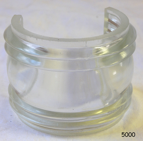
 Flagstaff Hill Maritime Museum and Village
Functional object - Fresnel Glass Lens, Early 20th century
A Fresnel lens is a type of composite compact lens developed by the French physicist Augustin-Jean Fresnel (1788–1827) for use primarily in lighthouses. Made from high-quality glass Fresnel lenses were used originally in lighthouses and later for many other applications They were later being used for automobile headlamps, brake, parking, and turn signal lenses, and many other applications. Fresnel lenses used in lighthouses were considered state of the art from the late 19th through to the middle of the 20th century. The subject item is a Fresnel replacement lens used in a ships navigation light. For lighthouses, these lenses have now been replaced with much less expensive and more durable aerobeacons, which themselves often contain plastic Fresnel lenses. The lens design allows the construction of lenses of large aperture and short focal length without the mass and volume of material that would be required by a lens of conventional design. A Fresnel lens can be made much thinner than a comparable conventional lens, in some cases taking the form of a flat sheet. The simpler dioptric (purely refractive) form of the lens was first proposed by Count Buffon and independently reinvented by Fresnel. The catadioptric form of the lens, entirely invented by Fresnel, has outer elements that use total internal reflection as well as refraction; it can capture more oblique light from a light source making the light visible from greater distances.The subject item at this time cannot be associated with a historical event, person or place, provenance is unknown, the item is a replacement for a ships navigation light and it is believed to have been produced before 1950.Fresnel glass replacement lens for a navigation side lamp of a ship. Nonewarrnambool, flagstaff-hill, flagstaff-hill-maritime-museum, maritime-museum, shipwreck-coast, flagstaff-hill-maritime-village, fresnel lens, maritime light, ships navigation light, augustin-jean fresnel, lighthouse lenses, lighthouse, navigation, warning light