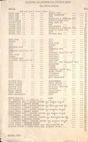
Showing 2900 items matching route%2072
-
 Tatura Irrigation & Wartime Camps Museum
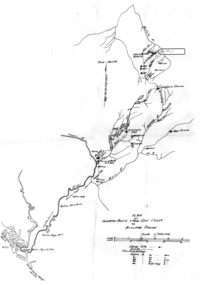
Map - Map - Photocopy, New Guinea Escape Route
At the end of January 1942 there was only about 250 men left in Wau, as the women and children had been evacuated by air a little earlier. With no planes to take the men they had to make their own way to Port Moresby and then travel by ship to Australia. Some men went down to Salamaua and made their way along the north coast, but small groups also made their way over the Owen Stanley Ranges; rafting down the Lakekamu RIver to Yule Island and by boat to Port Moresby. Donor Vanessa Kiessling's Father was part of the second group, and had drawn a detailed map of their route. This might be the same route taken by Rev. Willi Hertle (Ref C0750)Photocopy of New Guinea map showing escape routePlan of surveyed route from Edie Creek to Bulldog Dromepapua new guinea, escape, map, wau, willi hertle, kiessling -
 Ballarat Tramway Museum
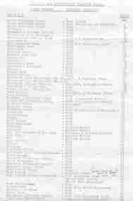
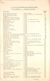
Document - List, Melbourne and Metropolitan Tramways Board (MMTB), MMTB Route Numbers listing - Electric Tramways, Nov. 1957
Foolscap size paper consisting of two pages giving a listing of Melbourne Electric Trams route numbers, held together with staple at top left hand corner. Dated November 1957 Originally printed, then duplicated.Written inscription of route 67 on page 1. Additional route 67 on page 2.mmtb, melbourne, route numbers, melbourne trams -
 Melbourne Tram Museum
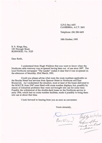
Letter, Ross Wilson, bus route numbers and opening dates, 18/10/1996 12:00:00 AM
Letter - from Ross Wilson of Canberra to Keith Kings regarding bus route numbers and the re-opening date for the Northcote cable tramway (23/3/1901). Industrial issues with bus routes.Has a note "Reply 31/10/95, copies of bus route no. list enclosed."trams, tramways, routes, cable trams, northcote, buses, east brunswick -
 Melbourne Tram Museum
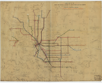
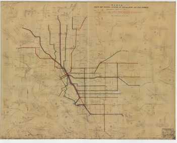
Drawing, Melbourne & Metropolitan Tramways Board (MMTB), "Route Map showing location of special work and pole numbers" "Electric Tramway Routes - showing routes in colours and numbers", late 1941
Map of the system shown at two inches = 1 mile. Drawing No. P5799. Shows crossovers, track layouts at junctions, signal cabins roads, railways and stations. Originally signed by Perway Engineer - 20/12/1940, though originally drawn in 1922. Has been marked up in coloured pencil to show the routes and route numbers. The plan shows the lines to Maribyrnong Munitions works along Cordite Ave and Wests Road and the track from Moonee Ponds to Union Road, which opened in July 1941, but not the extension to Essendon Airport built-in 1942. See Reg Item 1561 for a 1963 version and 1683 for a 1987 versionDemonstrates the use of a MMTB drawing to show tram routes and their route numbers at the time.Drawings - dyeline cloth backed print - titled - "Route Map showing location of special work and pole numbers" and subtitled - "Electric Tramway Routes - showing routes in colours and numbers". trams, tramways, mmtb, trackwork, tramways, junction, map, world war 2 -
 Melbourne Tram Museum
Document, Melbourne & Metropolitan Tramways Board (MMTB), "MMTB Route Numbers - Tram Routes" 1957 & 1965
Provides a list of tram route numbers in use at the time. Yields information about tram route numbers.Set of two, Gestetner printed lists, each comprising two foolscap sheets titled "MMTB Route Numbers - Tram Routes". .1 - dated November 1957 .2 - dated 27 Sept 1965Item 2 has "Obtained 2 May 1967" along top edge.tramways, trams, mmtb, route numbers, routes -
 Melbourne Tram Museum
Document, Melbourne & Metropolitan Tramways Board (MMTB), "MMTB Route Numbers - Bus Routes" 1961 & 1962
Provides a list of bus route numbers in 1961 and 1962. The 1962 sheet shows the additional routes following the take over of the bus routes in the Box Hill, Warrandyte and Ringwood areas.Yields information about bus route numbers.Set of two, Gestetner printed lists, foolscap sheets titled "MMTB Bus Routes Numbers". .1 - dated March 1961 - 1 sheet .2 - dated December 1962 - 2 sheetsItem 2 has "Obtained 2 May 1967" along top edge.tramways, trams, mmtb, route numbers, routes, buses -
 Melbourne Tram Museum
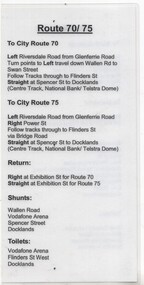
Document - Instruction, Yarra Trams, "Route 5/55", "Route 70/75", mid 2000's?
Instruction - A5 laminated sheet titled "Route 5/55" and "Route 70/75" giving details of the various timing points for Malvern routes 5 and 58 - to West Coburg, shunts, toilets, directions and turns.trams, tramways, malvern depot, drivers, training, operations, timetables, route 5, route 55, route 70, route 75 -
 Melbourne Tram Museum
Drawing, Melbourne & Metropolitan Tramways Board (MMTB), "Route Map showing location of special work and pole numbers" "All night tram routes in colours", late 1941
Map of the system shown at two inches = 1 mile. Drawing No. P5799. Shows crossovers, track layouts at junctions, signal cabins roads, railways, and stations. Originally signed by Perway Engineer - 20/12/1940, though originally drawn in 1922. Has been marked up in colour pencil to show the all-night routes and the individual services. The plan shows the lines to Maribyrnong Munitions works along Cordite Ave and Wests Road and the track from Moonee Ponds to Union Road, opened in July 1941, but not the extension to Essendon Airport built in 1942.Demonstrates a detail drawing of Melbourne tramways, junctions and pole numbers.Drawings - dyeline cloth-backed print - titled - "Route Map showing the location of special work and pole numbers" and subtitled - "All night tram routes in colours". trams, tramways, mmtb, trackwork, tramways, junction, map, world war 2, night trams -
 Melbourne Tram Museum
Document - List, Yarra Trams et al, "Destinations and Route Numbers - Trams by Route Number", Feb. 1999
The list provides a detailed list of destinations and route numbers for trams operated by Swanston Trams and Yarra Trams. Dated Feb. 1999. Gives Route number, including those no used, depot, main route, termini and destination. Includes a list of those routes operated by each depot.Yields information about tram routes and depot operations Feb. 1999.List - 6 A4 sheets, printed double sided.tramcars, tramways, tram routes, routes, yarra trams, swanston trams -
 Melbourne Tram Museum
Postcard, Traveller's Notes, Flinders St Station main entrance, Z81 (Route 67), and W6 981 (Route 1), 1995
Postcard - 3 panel full colour - by Traveller's Notes, of Flinders St Station main entrance, Z81 (Route 67), and W6 981 (Route 1). Divided back, published by Traveller's Notes, photos by Neil J Leed, 1995.trams, tramways, flinders st station, z class, w6 class, route 1, route 67, tram 81, tram 981 -
 Melbourne Tram Museum
Ephemera - Timetable/s, Swanston Trams, Set of 8 detailed timetables for each Malvern Depot route, Nov. 2000
Set of 8 detailed timetables for each Malvern Depot route dated 15 November 2000, giving direction, run, route and timing points for weekdays, Saturdays and Sundays. 1 - Route 67 - Carnegie 2 - Route 64 - East Brighton 3 - Route 5 - Malvern (last page loose) 4 - Route 3 - East Malvern 5 - Route 16 - St Kilda Beach - University 6 - Route 72 - Camberwell 7 - Route 8 - Toorak 8 - Route 6 - Glen Iristrams, tramways, timetables, route 3, route 5, route 6, route 8, route 16, route 64, route 67, route 72, carnegie, east brighton, malvern, east malvern, st kilda, toorak, camberwell, glen iris -
 Melbourne Tram Museum
Ephemera - Timetable/s, Yarra Trams, Set of five timetable books - 2002. Provide details about Yarra Trams, Metcards, route map, timing points and route description, 8/2000 to 9/2002
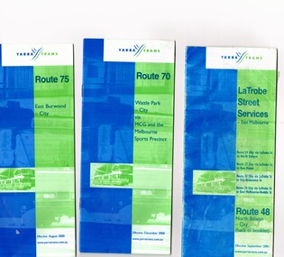
Set of five timetable books - 2002. Provide details about Yarra Trams, Metcards, route map, timing points and route description. .1 - printed 24 page book, blue green cover stapled timetable for "Route 75 - East Burwood - City" tram service, dated August 2000. .2 - printed 24 page book, blue green cover stapled timetable for "Route 70 - Wattle Park - City" tram service, dated December 2000. .3 - printed 24 page book, blue green cover stapled timetable for "La Trobe Street Services - East Melbourne" and "North Balwyn - City" tram service, dated September 2001. Covers Route 48, 24, 27, 30 and 34. Has Route 48 on the reverse of the book. .4 - printed 28 page book, blue green cover stapled timetable for "Route 86 - Bundoora / RMIT - Colonial Stadium via Bourke St" tram service, dated September 2002. .5 - printed 32 page book, blue green cover stapled timetable for "Route 109 - Port Melbourne - Mont Albert" and La Trobe St services (back of booklet) tram services, dated September 2001.trams, tramways, tickets, yarra trams, tram services, timetables, la trobe st, route 70, route 75, route 109, route 86, route 86, route 109, route 48, route 24, route 27, route 30, route 34 -
 Melbourne Tram Museum
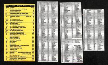
Document - List, The Met, "Camberwell Depot Destinations", "Route 70 Stop-Street Reference Nov. 05", "Route 75 Stop-Street Reference Nov. 05", c2005
Set of four lists, on laminated paper. .1 - "Camberwell Depot Destinations" list route, locations and destination code. Printed on yellow paper. .2 - "Route 70 Stop-Street Reference Nov. 05" - lists the streets and stop number in alphabetical order. .3 - "Route 75 Stop-Street Reference Nov. 05" - lists the streets and stop number in alphabetical order - A to L .4 - ditto, M to Y, Hospitals and Places of Interest.trams, tramways, yarra trams, camberwell depot, tram stops, destination roll, hospital -
 Melbourne Tram Museum
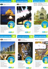
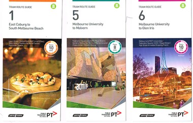
Ephemera - Tram Route Guides, Yarra Trams, Public Transport Victoria (PTV), "Tram Route Guide", Oct. 2011 to Oct 2012
Set of 23 Tram Route Guides, published during 2011 or 2012. Each comprises a vertical DL folded sheet, full colour for the nominated routes, with Yarra Trams, Myki and TramTracker logos, listing the stops, interchanges with bus and other tram services, ticketing zones, estimated frequencies with adverts for Night tram services, TramTracker and Myki tickets. .1 - Route 5 - Melbourne University to Malvern .2 - Route 16 - Melbourne University to Kew .3 - Route 24 and 30 - North Balwyn - Latrobe St and St Vincent's Plaza - Etihad Stadium .4 - Route 48 - North Balwyn - Victoria Harbour Docklands .5 - Route 55 - West Coburg - Domain Interchange .6 - Route 57 - West Maribyrnong to Flinders St Station .7 - Route 59 - Airport West - City .8 - Route 75 - City - Vermont South .9 - Route 78 and 79 - North Richmond - Prahran or St Kilda Beach .10 - Route 82 - Footscray to Moonee Ponds .11 - Route 96 - East Brunswick - St Kilda Beach .12 - ditto .13 - Route 112/11 - West Preston - St Kilda, West Preston - Victoria Harbour Docklands .14 - Route 70 - Wattle Park - Waterfront City Docklands .15 - Route 86/95 - Bundoora - Waterfront City Docklands and Melbourne Museum - City .16 - Route 1 - East Coburg - South Melbourne Beach .17 - Route 3/3a - Melbourne University to East Malvern .18 - Route 6 - Melbourne University to - Glen Iris .19 - Route 8 - Moreland to Toorak .20 - Route 64 - Melbourne University to East Brighton .21 - Route 67 - Melbourne University to Carnegie .22 - Route 72 - Melbourne University to Camberwell .23 - Route 109 - Box Hill - Port Melbourne and Route 31 - Hoddle St - Victoria Harbour - Docklands .24 - Route 75 - Vermont South - dated 10/2011 See Reg Item 2278 for 2016 versionstrams, tramways, timetables, maps, route 1, route 3/3a, route 5, route 6, route 8, route 11, route 16, route 24, route 30, route 31, route 48, route 55, route 57, route 59, route 64, route 67, route 70, route 72, route 75, route 78, route 79, route 82, route 86, route 95, route 96, route 109, route 112, east coburg, south melbourne, malvern, west maribyrnong, airport west, docklands, north balwyn, west coburg, domain interchange, north richmond, prahran, east brunswick, st kilda, vermont south, footscray, moonee ponds, kew, st vincent's plaza, preston, wattle park, bundoora, museum, south melbourne beach, east coburg, east malvern, glen iris, toorak, moreland, east brighton, carnegie, camberwell, box hill, port melbourne -
 Melbourne Tram Museum
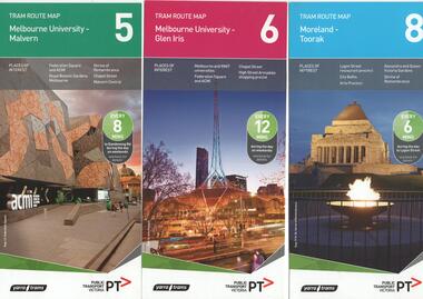
Ephemera - Tram Route Guides, Yarra Trams, Public Transport Victoria (PTV), "Tram Route Map", 1/2015 and 6/2015
Set of 7 Tram Route Maps, published during 2015. Each comprises a vertical DL folded sheet, full colour for the nominated routes, with Yarra Trams and PTV logos, listing the stops, interchanges with bus and other tram services, ticketing zones, estimated frequencies with adverts for Night tram services, TramTracker and Myki tickets. .1 - Route 5 - Melbourne University to Malvern .2 - Route 6 - Melbourne University to Glen Iris .3 - Route 8 - Moreland to Toorak .4 - Route 11 - West Preston - Victoria Harbour Docklands .5 - Route 19 - North Coburg - Flinders St Station .6 - Route 70 - Wattle Park to Waterfront City Docklands .7 - Route 72 - Melbourne University to Camberwell .8 - Route 1 - East Coburg - South Melbourne Beach .9 - Route 3 and 3A - Melbourne University to East Malvern .10 - Route 16 - Melbourne University to Kew .11 - Route 55 - West Coburg - Domain Interchange .12 - Route 57 - West Maribyrnong - Flinders St Station .13 - Route 59 - Airport West - Flinders St. Station .14 - Route 64 - Melbourne University - East Brighton .15 - Route 67 - Melbourne University - Carnegie .16 - Route 78 - North Richmond - Balaclava via Prahran .17 - Route 82 - Footscray - Moonee Ponds See Reg Item 2396 for 2012, 2278 for 2016 and 2940 for 2014 versionstrams, tramways, timetables, maps, route 1, route 3, route 5, route 6, route 8, route 11, route 16, route 19, route 55, route 57, route 59, route 64, route 67, route 70, route 72, route 78, route 82, east coburg, south melbourne, east malvern, kew, west coburg, west maribyrnong, airport west, east brighton, carnegie, north richmond, balaclava, footscray, moonee ponds, malvern, glen iris, moreland, west preston, north coburg, wattle park, camberwell -
 Melbourne Tram Museum
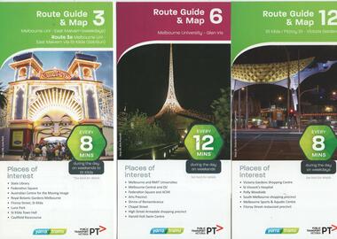
Ephemera - Tram Route Guides, Yarra Trams, Public Transport Victoria (PTV), "Tram Route Guide and Map", Oct. 13 to July 14
Set of 17 Tram Route Maps, published during 2013 and 2014. Each comprises a vertical DL folded sheet, full colour for the nominated routes, with Yarra Trams and PTV logos, listing the stops, interchanges with bus and other tram services, ticketing zones, estimated frequencies with adverts for Night tram services, TramTracker and Myki tickets. .1 - Route 3 - East Malvern - Melbourne Uni and 3A via St Kilda (Sat and Sun) .2 - Route 6 - Melbourne University to Glen Iris .3 - Route 12 - St Kilda - Victoria Gardens .4 - Route 16 - Kew via St Kilda .5 -Route 30 - St Vincent's Plaza - Etihad Stadium .6 - Route 55 - West Coburg - Domain Interchange .7 - Route 59 - Airport West - City (Elizabeth St) .8 - Route 64 - Melbourne University - East Brighton .9 - Route 70 - Wattle Park to Waterfront City Docklands .10 - Route 75 - Docklands - Vermont South .11 - Route 78 - North Richmond - Balaclava .12 - Route 82 - Moonee Ponds - Footscray .13 - Route 86 - Bundoora - Waterfront City .14 - Route 96 - East Brunswick - St Kilda Beach .15 - Route 109 - Box Hill - Port Melbourne .16 - Route 112 and 11 - West Preston - St Kilda and West Preston - Victoria Harbour Docklands .17 - Route 24 - North Balwyn to Etihad Stadium See Reg Item 2396 for 2012, 2278 for 2016 and 2939 for 2015 versionstrams, tramways, timetables, maps, route 3, route 6, route 11, route 12, route 16, route 24, route 30, route 55, route 59, route 64, route 70, route 75, route 78, route 82, route 86, route 96, route 109, route 112, east malvern, glen iris, victoria gardens, kew, st vincent's plaza, west coburg, airport west, east brighton, wattle park, vermont south, north richmond, moonee ponds, footscray, st kilda, docklands, west preston, victoria harbour, north balwyn, etihad stadium -
 Ballarat Tramway Museum
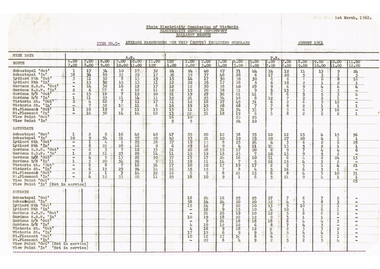
Document - Report, State Electricity Commission of Victoria (SEC), "Average Passengers per trip (route) including Scholars", "Passenger density and direction per hour each route", post 8/1961
Yields information about the passenger traffic in Ballarat during August 1961 and passenger density.Set of four type reports on statistics for the Ballarat tramway system, for August 1961. .1 - "Average Passengers per trip (route) including Scholars" .2 - "Passenger density and direction per hour each route - weekdays" - see image 2a and 2b .3 - ditto - Saturdays 4 - ditto - Sundays See Reg Item 7921 for similar reports.trams, tramways, reports, passengers, employees, fares, tramcars, routes, revenue, finances, tickets -
 Melbourne Tram Museum
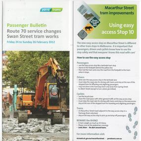
Pamphlet, Public Transport Victoria (PTV), "Route 70 service changes - Swan Street tramway works", "Macarthur St tram stop 10", "Tram route 86 Improvements - using trams stops 31 and 32", "Tram route 86 Improvements - High Street Westgarth", c2012 to 2013
Set of four pamphlets advising of changes to tram services for the installation of various trams stops or track works. .1 - "Route 70 service changes - Swan Street tramway works" - Hoddle St intersection - 3 fold DL - Feb. 2012. .2 - "Macarthur St tram stop 10" - super stop, known as an "Easy Stop" - gives a map of the stop and how it may be used. Single DL sheet on light card. .3 - "Tram route 86 Improvements - using tram stops 31 and 32" - gives a map of the stop and how it may be used. Single DL sheet on light card. \.4 - "Tram route 86 Improvements - High Street Westgarth" - explains the use of the Central Island Platform stops - stops 27 and 30, including a diagram, printed on 3 fold DL paper. Produced by Public Transport Victoria and Yarra Trams with VicRoads.trams, tramways, public transport, tram stops, high st, northcote, route 70, route 86, macarthur st, swan st -
 Melbourne Tram Museum
Ephemera - Tram Route Guides, Yarra Trams, Public Transport Victoria (PTV), "Tram Route Guide", Feb. 2016
Set of 18 Tram Route Guides, published during 2016. Each comprises a vertical DL folded sheet, full colour for the nominated routes, with Yarra Trams and PTV logos, listing the stops, interchanges with bus and other tram services, ticketing zones, estimated frequencies with adverts for Night tram services, TramTracker and Myki tickets. .1 - Route 1 - East Coburg to South Melbourne Beach .2 - Route 5 - Melbourne University to Malvern .3 - Route 6 - Melbourne University to Glen Iris .4 - Route 8 - Moreland to Toorak .5 -Route 57 - West Maribyrnong to Flinders St Station (2 copies) .6 - Route 70 - Wattle Park to Waterfront City Docklands .7 - Route 72 - Melbourne University to Camberwell .8 - Route 75 - Vermont South to Etihad Stadium / Bourke St Docklands .9 - Route 82 - Footscray to Moonee Ponds .10 - Route 19 - North Coburg to Flinders St Station .11 - Route 55 - West Coburg to Domain Interchange (two copies held) .12 - Route 59 - Airport West to Flinders St Station .13 - Route 30 - St Vincent's Plaza to Ethida Stadium Docklands .14 - Route 12 - Victoria Gardens to St Kilda / Fitzroy St .15 - Route 64 - Melbourne University to East Brighton .16 - Route 78 - North Richmond to Balaclava (via Prahran) .17 - Route 86 - Bundoora (RMIT) to Waterfront City Docklands .18 - Route 96 - East Brunswick to St Kilda Beach .19 - Route 11 - West Preston to Victoria Harbour Docklands ,20 - Route 16 - Melbourne University to Kew via St Kilda .21 - Route 48 - North Balwyn to Victoria Harbour Docklands .22 - Route 67 - Melbourne University to Carnegie .23 - Route 109 - Box Hill to Port Melbourne See Reg Item 2396 for 2012, 2939 for 2015 and 2940 for 2014 versions Items .13 to .18 added 2/9/18Item 11 has the "5" changed to "8" in Texta - see history of object.trams, tramways, timetables, maps, route 1, route 5, route 6, route 8, route 11, route 16, route 132, route 19, route 30, route 48, route 55, route 57, route 59, route 64, route 67, route 70, route 72, route 75, route 78, route 82, route 86, route 96, route 109, east coburg, west coburg, airport west, north coburg, south melbourne, malvern, glen iris, moreland, toorak, west maribyrnong, wattle park, docklands, camberwell, vermont south, footscray, moonee ponds, st vincent's plaza, victoria gardens, east brighton, north richmond, balaclava, bundoora, east brunswick, west preston, kew, north balwyn, carnegie, box hill -
 Flagstaff Hill Maritime Museum and Village
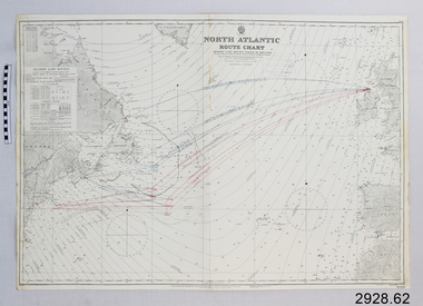
Document - Navigation Chart, North Atlantic : Route Chart showing Lane Routes North of Ireland
British Admiralty Navigation Chart - North Atlantic : Route Chart showing Lane Routes North of Irelandwarrnambool, shipwrecked-coast, flagstaff-hill, flagstaff-hill-maritime-museum, maritime-museum, shipwreck-coast, flagstaff-hill-maritime-village, shipwrecked-artefact, navigation chart, british admiralty navigation chart, british admiralty, north atlantic, route chart -
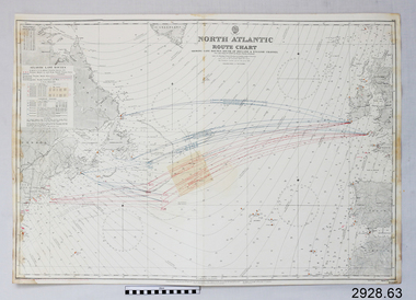 Flagstaff Hill Maritime Museum and Village
Document - Navigation Chart, North Atlantic : Route Chart showing Lane Routes South of Ireland & English Channel
British Admiralty Navigation Chart - North Atlantic : Route Chart showing Lane Routes South of Ireland & English Channelwarrnambool, shipwrecked-coast, flagstaff-hill, flagstaff-hill-maritime-museum, maritime-museum, shipwreck-coast, flagstaff-hill-maritime-village, shipwrecked-artefact, navigation chart, british admiralty navigation chart, british admiralty, north atlantic route chart, north atlantic -
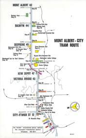 Melbourne Tram Museum
Map, Melbourne & Metropolitan Tramways Board (MMTB), Set of 15 tram route maps, 1977 to 1979
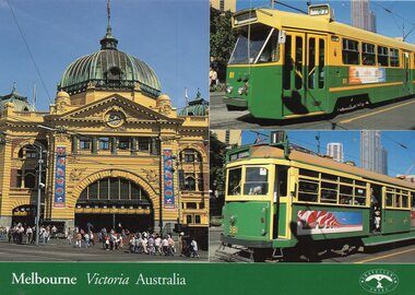
Series of 15 colour route maps for various tram lines or groups of tram lines for the MMTB. Some have the Transport Information Centre telephone printed on them, others have a label stuck on. Some are finished with a plastic laminate finish on either one or both sides. Show the major cross streets, parks, schools, other tram routes, major stop numbers and railway lines. Two copies of each held unless noted otherwise. .1 - Mont - Albert City - R11/77, shows routes 43. 47. 45. 44 .2 - Malvern, East Malvern, Carnegie and East Brighton Tram Routes (from St Kilda Junction) - R1/79 - shows routes 5, 3, 67, 66, 61, 62 and 64. .3 - Swanston St tram guide - R1/79 - lists all routes and route numbers that branch or cross Swanston St between Grattan St and St Kilda Junction. .4 - St Kilda Rd Tram Routes R12/77 - details South Melbourne Beach, route 1 and route 2 and St Kilda Beach routes 15, 16 and 55 otherwise shows were the various routes branch off St Kilda Road. Copy 1 has "P14909" in pencil in the bottom right hand corner. .5 - Kew - St Kilda Beach - R1/79 - Route 69. .6 - Footscray - Moonee Ponds - R3/81 - Route 82 .7 - Flinders St tram routes - R5/78 - North Balwyn, East Burwood, routes 48, 40, 41, Hartwell, 28, 74 and 75 .8 - William St tram routes - Route 55, 56 and 63 - South Melbourne Depot and Domain. copy 2 has "P14913" in bottom right hand corner. .9 - Toorak Camberwell and Glen Iris tram routes with Camberwell Junction and Malvern Town Hall, R1/79, routes 8, 7, 6, 72 and 73 shown. .10 - Swanston St tram routes - R12/77 - shows all the Swanston St routes, including East Coburg and Moreland. .11 - Bourke St tram routes - R4/77 - East Brunswick Blyth St and East Preston Tyler St and intermediate routes, routes 95, 96, 97, 90, 89 and 88. .12 - as for .11, dated 1/85, showing extension to La Trobe University - has Metropolitan Transit logo. Only 1 copy held. Also shows route 92 and 87. .13 - Batman Ave tram routes - R9/77 - Wattle Park, North Richmond and Prahran - routes 70, 71, 78 and 79. .14 - City route guide - R9/77 - showing all route numbers and destinations that passed through the CBD. .15 - Elizabeth St tram routes - R12/77 - Essendon Airport, West Maribyrnong, North Coburg lines, routes 50, 58, 60, 54, 57, 52. 49, 59, 18, 20 and 19. Copy 1 has "P14905" in pencil in bottom left hand corner.trams, tramways, maps, route guide, route numbers, routes, mont albert, route 43, route 47, route 45, route 44, route 42, malvern burke rd, east preston, carnegie, east brighton, south caulfield, route 5, route 3, route 67, route 62, route 64, route 66, glenhuntly tram depot, swanston st, st kilda rd, south melbourne beach, st kilda beach, route 1, route 2, route 15, route 16, route 55, kew- cotham road, route 69, route 79, route 82, footscray, moonee ponds, flinders st, north balwyn, kew, east burwood, burwood, hartwell, richmond, route 48, route 40, route 41, route 28, route 74, route 75, route 56, route 63, william st, west coburg, toorak, camberwell, glen iris, malvern town hall, route 72, route 73, route 7, route 8, bourke st, route 6, route 95, route 96, route 97, route 90, route 89, route 89, east preston, east brunswick, la trobe university, clifton hill, route 92, route 87, route 70, route 71, route 78, route 79, north richmond, prahran, wattle park, essendon airport, west maribyrnong, north coburg, route 50, route 58, route 60, route 54, route 57, route 52, route 49, route 59, route 18, route 20, route 19, batman ave -
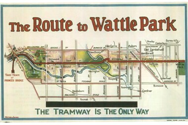 Melbourne Tram Museum
Drawing - Illustration, Tramway Museum Society of Victoria (TMSV), "The Route to Wattle Park", 16/03/2006 12:00:00 AM
Illustration from a TMSV Calendar, "The Route to Wattle Park" showing the route overlain in red on a street map. From an original MMTB Poster.trams, tramways, mmtb, posters, illustrations, wattle park -
 Melbourne Tram Museum
Document - List, Melbourne & Metropolitan Tramways Board (MMTB), "MMTB Route Numbers - Tram Routes - Commencing as from Sunday, 1st November 1970", Oct. 1970
Six page foolscap printed (Gestetner?) document titled "MMTB Route Numbers - Tram Routes - Commencing as from Sunday, 1st November 1970", listing all routes. Introduced numbers with "3" and stopped the use of letters, eg "4D". Provides information on amalgamated routes, route numbers to be shown when running in and out of depots, city termini to depot, and to city from depots. Pages 5 and 6 provide a list of bus route numbers. For the previous listing see Rec Number 1424. Second copy added 30-1-2017trams, tramways, mmtb, ptc, buses, route numbers, routes -
 Melbourne Tram Museum
Ephemera - Timetable, Public Transport Corporation (PTC), Kew (Cotham Road) - St Kilda Beach, Route 69, Apr. 1995
.1 - Printed 12 page book stapled timetable for Kew (Cotham Road) - St Kilda Beach, Route 69 tram service, dated April 1995. The "The Met" logo, published by the Public Transport corporation. Document No. TT015 Provides a map, description of route, time points, timetable, ticketing information, some ticketing information, introduction by the Manger Malvern Depot, including a photo - Warren Peart and an image of a single truck (No. 8) tram available for hire as a party tram. .2 - Route 1, 22 - East Coburg/Moreland Sth Melbourne / Arts Centre - 2/4/95, revised 9/95 .3 - Route 3 - East Malvern - City - April 1995 .4 - Route 5 - Malvern (Burke Road - City - April 1995 .5 - Route 6 - Glen Iris - City - April 1995 .6 - Route 8 - City - April 1995 .7 - Route 11 - City - April 1995 .8 - Route 12 - Sth Melbourne Beach and St Kilda Beach - City - April 1995 .9 - Route 16 - St Kilda Beach - City - April 1995 .10 - Route 19 - North Coburg - City - Nov 1994, revised 8/1995 .11 - Route 48 - North Balwyn - City - 30/4/1995, revised 9/1995 .12 - Route 55 - West Coburg - Domain Rd Interchange - 11/1994 .13 - Route 64 - East Brighton - City - April 1995 .14 - Route 72 - Camberwell - City - April 1995 .15 - Route 75 - East Burwood - City - April 1995, revised 8/1995 .16 - Route 78/79 - North Richmond - St Kilda Beach or Prahran - April 1995 .17 - Route 82 - Moonee Ponds - Footscray - 11/1994 .18 - Route 96 - St Kilda Beach - East Brunswick - 3/1994 .19 - City - East Melbourne - LaTrobe St Service - April 1995 .20 - Route 86 - Bundoora - City - Oct 1995trams, tramways, tickets, the met, tram services, timetables, route 69, route 1, route 22, route 3, route 5, route 6, route 8, route 11, route 12, route 16, route 19, route 48, route 55, route 64, route 72, route 75, route 78, route 79, route 82, route 86, route 96, la trobe st - east melbourne -
 Melbourne Tram Museum
Pamphlet, Yarra Trams, "On some route numbers you will see an 'a' or 'd' ", c2012
Pamphlet - folded DL full colour printed on gloss paper, titled "On some route numbers you will see an 'a' or 'd' " advising passengers of the letters that could appear on tramcar route number - 'a' - altered, 'd' - depot. Notes that some route numbers are not published, gave an example of route 33, 51 or an 89. Printed c 2012 Two copies held.trams, tramways, route numbers, destination indicators, tramcars, depot -
 Melbourne Tram Museum
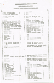
Document - List, Wal Jack, "Official list of route numbers, at November 1957", Nov. 1957
Two page photocopied printed list, foolscap sheets titled "Official list of route numbers, at November 1957", giving the list of route numbers for all numbers to 97 including A to E, showing where numbers and most letters not used at the time. Does not give bus route numbers. Shows the un-numbered routes. List prepared by Wal Jack.trams, tramways, mmtb, route numbers, routes -
 Melbourne Tram Museum
Document - Research Notes, Ross P Baird, "Prahran & Malvern Tramways Trust - route numbers and colour lights", 1988
Single page A4 sheet titled "Prahran & Malvern Tramways Trust - route numbers and colour lights", giving details of the PMTT destination indicators, route numbers, routes and colour lights used on trams. Prepared by Ross P Baird 1988.trams, tramways, malvern depot, kew depot, routes, destination indicators, pmtt -
 Melbourne Tram Museum
Pamphlet, Public Transport Victoria (PTV), "Buses replace trams - Route 58 and Route 78", Jun. 2021
Pamphlet - 4 fold DL, titled ""Buses replace trams - Route 58 and Route 78", June 2021 for the installation of a level platform stop at South Yarra Station, cabling from the Daly St substation and trackwork on route 78 as well. Image i2 shows a plan of the stop - source from https://s3.ap-southeast-2.amazonaws.com/hdp.au.prod.app.vic-engage.files/3016/2201/0888/PTVH5474_South_Yarra_Tram_Design_Plan_Map_A1_v8_FA.jpg at the time. Has a map of the replacement services. Has PTV and Victorian Government logos. image i3 - downloaded from the Yarra Trams website - details of the project including upgrading the Power supply. two copies held. .1 - coffee voucher for two days (19/6 and 20/6) while tram stop works were being carried out.trams, tramways, route 58, trackwork, bus replacement, south yarra, daly st substation -
 Melbourne Tram Museum
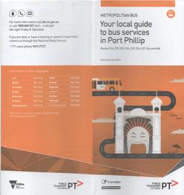
Document - Bus Route Guides, Public Transport Victoria (PTV), "Bus Route Guide - Your local guide to bus services in Port Phillip", 2016
Bus Route Guides, 12 section fold out guide, printed on recycled paper titled "Bus Route Guide - Your local guide to bus services in Port Phillip", detailing the bus services within the City of Port Phillip. Published by the PTV 2016. Has a detailed map of the various routes, and a list of the bus routes and their various stops. Collected as it relates today to the former MMTB Bus routes in the area. Has the logos of PTV, Transdev and CDC Melbourne on the front.trams, tramways, timetables, maps, port melbourne, city of port phillip, buses, south melbourne, st kilda