Showing 314 items matching scenery
-
 Tatura Irrigation & Wartime Camps Museum
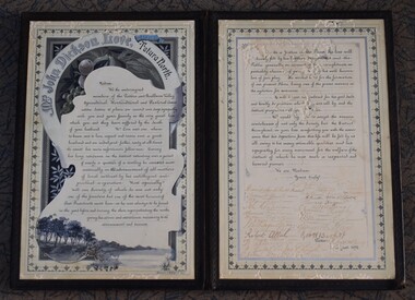
Bereavement Tribute, Ferguson and Mitchell Ltd, 1892
Presented to Mrs Love in sympathy on the death of her husbandHand-painted Calligraphic tribute for Mrs. John Dickson Love with black covers. Hand Painted border depicting fruit and scenery. Signed by members of the Goulburn Valley Agricultural, Horticultural and Pastoral Association.Mrs. John D Love. Tatura North August 6th 1892mrs john dickson love, john dickson love, love, goulburn valley agricultural, horitcultural and pastoral association -
 Halls Gap & Grampians Historical Society
Postcard - B/W
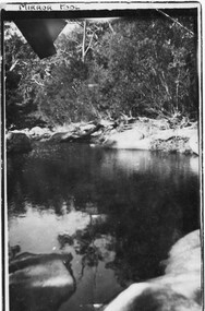
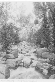
The location of the photo was in the vicinity of Myrtlebank, upper Halls Gap. The pool was called "Mirror Pool"Photo shows large pool of water bordered by the sandy banks of a creek (Fyans Creek).Hand written "A Happy New Year to all PS this is close to where we live Typed Post card, correspondence, Address only Kodak, Australia. 'Mirror Pool" written in ink in top, left border of photo.scenery -
 Halls Gap & Grampians Historical Society
Photograph - B/W, C 1900s
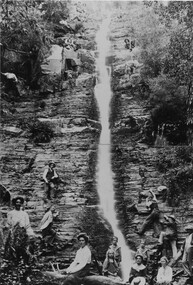
Silverband Falls. The original photo is in a frame and is on display in the History Room. ** Oct 2009: The original has 'disappeared' !!Photo shows 22 people below, alongside and above falls Logs and ferns in foregroundscenery, waterfalls, scenery, silverband falls -
 Phillip Island and District Historical Society Inc.
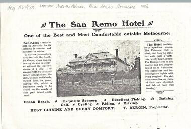
Newspaper clippings, 1903
Donated by Miss Edith Elms via Chrisy Northcote. Show the development of San Remo as a recreational area in 1903.Photocopy of San Remo Hotel advertisement inserted by T Bergin - Proprietor - undated, listing activities - ocean beach, exquisite scenery, excellent fishing, bathing, golf, cycling, riding, driving. Photograph of San Remo Hotel top middle.local history, documents, newspapers, san remo, local area development by europeans, black & white newspaper clipping, advertisement, newspapers san remo -
 Halls Gap & Grampians Historical Society
Photograph - Sepia, C 1920s (?)
Men on the upstream embankment of Lake Wartook.Photo shows five men (one only partly visible n the left side) on the rocky embankment of a large body of water (Lake Wartook).scenery, lake wartook -
Halls Gap & Grampians Historical Society
Photograph - B/W, C 1920s
The house in the photo is the caretaker's residence at Lake Wartook. The men and dogs are standing next to the intake tower.The photo shows a small weatherboard house, with a group of eight men and three dogs standing beside it, on the side of a large lake (Lake Wartook). The house is on a platform, built up with stones and there is a stone pillar with platform leading to it in the lake to the right of the men. There is bush with hills rising above them in the background.scenery, lake wartook -
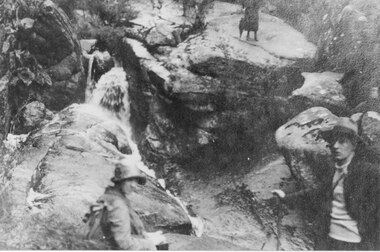
 Halls Gap & Grampians Historical Society
Photograph - B/W
The creek is Stoney CreekPhoto shows man sitting on rock in middle of creekPicard Stawell Stony Creek (sic) Grampians scenery, stoney creek -
 Halls Gap & Grampians Historical Society
Postcard - B/W, C 1920s
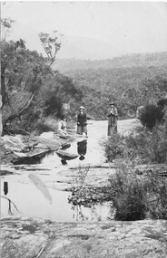
Postcard shows 3 women, 1 seated, 2 standing on flat rock around water pools Area unknownPost Card, Correspondence, Address only, Kodak, Australiascenery, people -
 Halls Gap & Grampians Historical Society
Postcard - Coloured, C 1950s
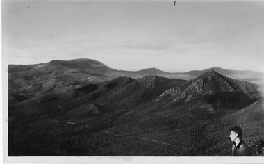
This photo is of an unknown location in the Grampians.Photo shows a range of hills. The head and shoulders of young man can be seen in the bottom right hand cornerPost Card Correspondence, Address only Kodak Autraliascenery, grampians ranges -
 Halls Gap & Grampians Historical Society
Postcard - B/W
The Wonderland range from the Halls Gap side. the cleared land was used for grazing purposes.Photo shows peaks in background with cleared land in the foregroundPost Card Correspondence Address 122 Grampiansscenery, wonderland range -
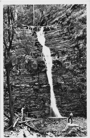 Halls Gap & Grampians Historical Society
Postcard - Sepia, C 1930s
One postcard has an unsigned message on the back; not addressed and not postmarked: "These falls we did on the round trip of 16 miles on the Tuesday. They are very pretty and have more water flowing than what is seen in the picture. They can be seen clearly from the road." * all three postcards held are originals.Post Card shows Silverband Falls with male standing on rock in foregroundFront bottom: "The Rose Series P.619, Silverband Falls, The Grampians Vic". Hand Written message on back: "These falls we did on the round trip of 16 miles on the Tuesday They are very pretty and have more water flowing than what is seen in the picture. They can be seen clearly from the road.". Back: "Post Card, the "Rose Series De Luxe. A Real Photograph Produced in Australia".scenery, silverband falls -
 Halls Gap & Grampians Historical Society
Photograph - B/W, C 1900s
Photo shows 2 women and 1 child in background Waterfall on left location unknownscenery, waterfalls -
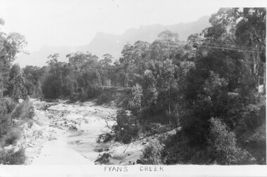 Halls Gap & Grampians Historical Society
Photograph - B/W
Photo shows Fyans Creek, looking South West towards the Pinnacle. View probably taken from the bridge. Fyans Creek appears to be very wide, perhaps after a flood.scenery, fyans creek -
 Halls Gap & Grampians Historical Society
Photograph - B/W, C 1920s
Photo shows three walkers, one male and two females, on the track to "The Pinnacle". The man is holding onto either a walking stick or some railing. One woman is holding an umbrella.scenery, wonderland range -
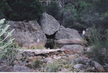 Halls Gap & Grampians Historical Society
Photograph - Coloured, 24/04/2005
The photo shows a small weir on the Stoney Creek which used to supply water to a number of early businesses in Halls Gap, such as the general store and Grampians House. Each business ran a pipe from the weir to their premises and three outlets can still be seen embedded in the wall. Record 248 was taken at the same time.Photograph of a woman approaching a small weir with three large boulders behind it. The original level of the weir can be seen on the boulders. The additional image is a description of how to get to the weir.scenery, stoney creek -
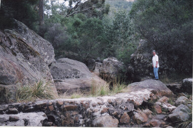 Halls Gap & Grampians Historical Society
Photograph - Coloured, 24/04/2005
The photo shows a small weir on the Stoney Creek which used to supply water to a number of early businesses in Halls Gap. The weir's former level can be seen on the large rocks behind but once a town water supply was installed, the wall of the weir was breached. Record 247 was taken at the same time and includes an image of a description of how to get to the weir.Photograph of a woman approaching standingh on a rock near a small weir. There are large boulders behind it which show the former level of the weir.scenery, stoney creek -
 Halls Gap & Grampians Historical Society
Photograph - B/W
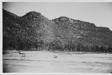
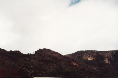
This is a photo of Chatauqua Peak, which is named after the Chautauquans, who held summer camps in Halls Gap in the 1890sA photo of bushland with rocky mountain rising behindscenery, grampians ranges -
 Halls Gap & Grampians Historical Society
Photograph - Coloured
This is a photo of Maggie's Peak, where Chautauqua picnics were held. This peak overlooked the are in Halls Gap where the concerts were held.A photo of a small peak with a rocky cliff near the summit and a larger hill rising behind. There is a edge of a large tree visible in the right foreground.scenery, grampians ranges -
 Halls Gap & Grampians Historical Society
Photograph - Coloured
Maggie's Peak where the Chautauqua concerts were overlooked.The photo shows a rock ridge with a small peak at it's centre. There is a tiny patch of blue showing through the cloudy sky on the top, just right of centre.scenery, grampians ranges -
 Halls Gap & Grampians Historical Society
Photograph - Coloured
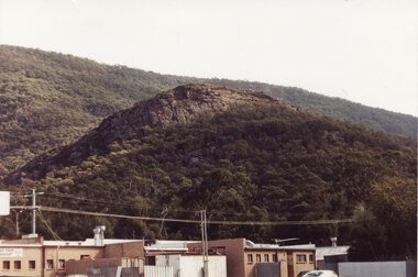
Chautauqua peak overlooking the Halls Gap Community businesses.The photo shows a peak (Chautauqua Peak) rising above a group of buildings. A larger slope rises behind the peak in the background.scenery, grampians ranges -
 Halls Gap & Grampians Historical Society
Photograph - B/W
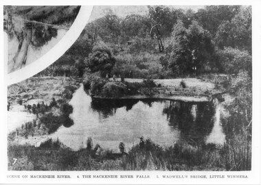
This is the pondage below Wartook Lake embankment. The photo is from the Weekly Times. Oddly, the inscription on the bottom of the photo does not appear to relate to the images.Photo shows a river with four people standing on a sandy bank. Four other people can be seen in the forgrouns standing on the near bank. A smaller inset at the top left corner seems to show a tee reflected in water.scenery, mackenzie river -
 Halls Gap & Grampians Historical Society
Postcard - Sepia, C 1940s
Three people looking up at Broken Falls.Photo shows three people, a woman and two men, standing on rocks at the base of a waterfall, which falls in two distinct parts (Broken Falls).scenery, waterfalls -
 Halls Gap & Grampians Historical Society
Photograph - B/W, C 1940s
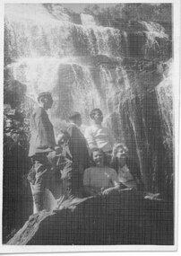
Portrait in front of MacKenzie Falls.Photo shows four men and two women on a large rock at the base of a large waterfall (MacKenzie Falls).scenery, mackenzie falls -
 Halls Gap & Grampians Historical Society
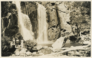
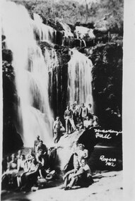
Photograph - B/W, C 1930s
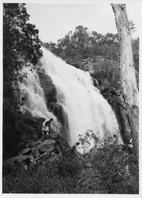
This photo was taken by Gilbert Rogers, a well known local photographer of the day. Note that the inscription says MacKenzie Fall with no "s".Photo shows a large group (twenty two people) posed on rocks at the base of a large waterfall (MacKenzie Falls)."Mackenzie Fall Rogers 1(?)12" inscibed lower right of photo.scenery, mackenzie falls -
 Halls Gap & Grampians Historical Society
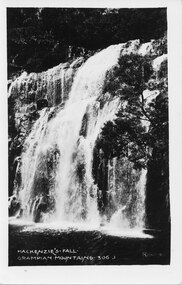
Photograph, Oct-27
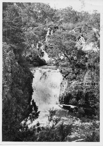
The photo was taken by Gilbert Rogers, a well known local photographer. Note that the inscription says MacKenzie Fall with no "s".A photo of a large waterfall (MacKenzie Falls) taken from the lower right side."MacKenzie's Fall. Grampians Mountains. 306 J" inscribed on lower left of photo. "Rogers" inscribed on lower right of photo.scenery, mackenzie falls -
 Halls Gap & Grampians Historical Society
Photograph - B/W
A photo of Broken Falls.A photo of a cascading set of falls, falling as two separate streams (Broken Falls).scenery, waterfalls -
 Halls Gap & Grampians Historical Society
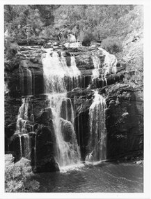
Photograph - B/W, C 1960s
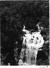
A Forestry Commission photo of MacKenzie Falls.Photo shows a large waterfall (MacKenzie Falls), taken from a fairly high vantage point. The river comes into the falls in two separate streams and there is a large volume of water flowing. The falls are surrounded by thick bush."Publicity & Public Relations branch. When reproducing please Acknowledge FORESTS COMMISSION, VICTORIA. Negative No. 322-2" stamped on rear (except negative number, which is hand written in pen)scenery, mackenzie falls -
 Halls Gap & Grampians Historical Society
Photograph - B/W, C 1940s (?)
This photo is part of promotional material for tourism, and was produced by Victorian Railways.The photo shows four people scrambling down rocks at the side of a large waterfall (MacKenzie Falls).'Copyright Photograph. This photograph may be reproduced on condition that it is acknowledged as "Victorian Railways Photograph".' stamped on back. "P. 3504" written on back in pencil. "MacKenzie Falls" written on back in blue ink.scenery, mackenzie falls -
 Halls Gap & Grampians Historical Society
Photograph - B/W
This is a photo of Broken and Drummond Falls. It is part of promotional material for tourism, and was produced by Victorian Railways.The photo shows a series of cascades leading down to a wider set of falls, all surrounded by bush.'Copyright Photograph. This photograph may be reproduced on condition that it is acknowledged as "Victorian Railways Photograph".' stamped on back. "P. 3500" written on back in pencil. "Broken & Drummond Falls" written on back in blue ink.scenery, waterfalls -
 Halls Gap & Grampians Historical Society
Photograph - B/W, C ?
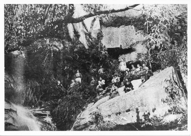
This photo has been copied from an article in the Weekly Times. The falls were in the Roses Gap area and there was once a track leading there. It is probable that the group went there by horse drawn vehicle.The photo shows a group of adults seated on a rocky outcrop at the base of a waterfall, in bushland beside a running creek (at left of photo). All are dressed formally.scenery, waterfalls