Showing 88 items matching volcano
-
 Federation University Historical Collection
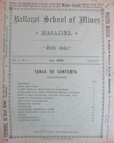
Magazine - Booklet, Ballarat School of Mines Student's Magazine, July 1899, 1899
Table of contents: Editorial, News and Notes, A few hints on histological technique, Summaries and notes from the mining journals, Professor A. Mica Smith B.Sc., Notes on Victorian geology, The origin of diamonds, Hydraulic mining, Volcanoes, Analytical chemistry notes, Some things we ought to do, Sports, Correspondence, Editorial notes.Pale green booklet of 10 pages. ballarat school of mines, students' magazine, g. e. saunder, w. wallace, j. booth, f. farnell, h. waller, a. h. freeman, w. e. hearman, professor dawbarn, e. gutheil, a. selwyn brown, h. watson, a. w. k. peirce, professor mica smith, w. bradford, henry watson, mr e. faribault, j. h. parsons, j. holmes pollock, t. s. hart, thomas hart, alfred mica smith, a. e. c. kerr, g. g. bonney, histological technique, diamonds, victorian geology, massey-harris bicycles, adelaide school of mines, ballarat school of mines colours, ballarat school of mines motto, ballarat school of mines badge, w.hirt, e. byron moore, britannia gold mine, visitors, j. bryant, premier mine coolgardie, last chance gold mine, g.e. saunder, ivanhoe mine kalgoorlie, black horse cyanide works, edgerton, hercules mine, mount reid, tasmania, f. parnell paul, zeehan school of mines, a.h. freeman, crown point gold mining co, w.e. hearman, parker's range, southern cross, w.a., trappean rocks, hydraulic mining, a.e.c. kerr, volcanoes, f.g. bonney, l.j. austine and co., downer and co, carter and werner -
 Ballarat Heritage Services
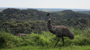
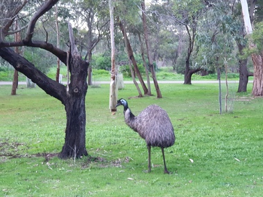
Photograph - Colour, Clare Gervasoni, Interpretation Centre at Tower Hill and Emus, 2016, 31/12/2016
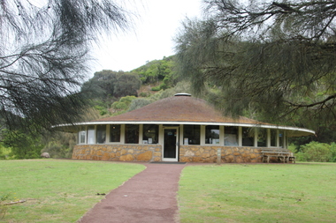
The interpretation centre at Tower Hill was designed by Robin Boyd. A number of colour photographs showing the Interpretation Centre at Tower Hill, and an number of emus.tower hill, volcano, robin boyd, emu -
 Ballarat Heritage Services
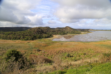
Photograph - Colour, Volcanic Crater at Tower Hill, 2017
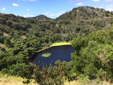
Tower Hill is a volcanic formation believed to have erupted about 32,000 years ago. Its formation is known as a "nested maar" and it is the largest example of its type in Victoria. During formation, molten lava pushed its way up through the Earth’s crust and encountered a layer of water-bearing rock. Violent explosions followed creating a shallow crater which later filled with water to form the lake. Further eruptions occurred in the centre of this crater, creating the islands and cone shaped hills. In 1892 Tower Hill became Victoria’s first National Park. In 1961, Tower Hill became a State Game Reserve under the then Fisheries and Wildlife Department and a major re-vegetation program began. (https://www.towerhill.org.au/index.php/about-reserve/history, accessed 23 December 2019)Colour photographs of a lake in a volcanic crater at Tower Hill, Victoria. volcano, crater, lake, tower hill -
 Ballarat Heritage Services
Photograph - Photograph - Colour, Clare Gervasoni, Mount Franklin from Smeaton, 22/09/2013
An extinct volcanic mountain known as Mount Franklin from Smeaton, Victoriamount franklin, volcano, smeaton, lalgambook -
 Ballarat Heritage Services
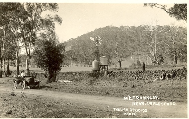
Photograph - Postcard, Thelma Studios, Mount Franklin Near Daylesford
Black and white postcard of a car in front of a drystone wall, with Mt Franklin in the background. mount franklin, volcano, drystone walls, lalgambook -
 Bendigo Military Museum
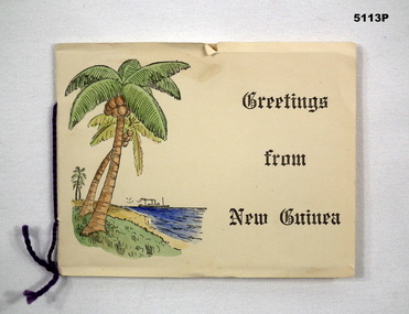
Card - CARD, CHRISTMAS, c1939-1941
Refer to Cat 5109PThis is a folded cardboard card. Inside is a black & white photo of a volcano. Printed on the inside page within the card are the words; " With all good wishes for Christmas and the New Year". On the front cover is a drawing of palm trees, ocean and a ship with the words "Greetings from New Guinea" is printed in black ink. The card has a small piece of purple wool acting has a decorative binder.Written in ink, on the inside page is - "From E H Hildebrandt VX25591 10-12-41" ww2, rabaul, new guinea, christmas card, souvenir -
 Southern Sherbrooke Historical Society Inc.
Information Folder - geology of Dandenong Ranges
Information folder containing items pertaining to the geology of the Dandenong Ranges, including material prepared by Betty Hotchin for a talk to the Kallista Tourism course. Contents:-/typescript, re. basic features/photocopy, "The Dandenongs volcano and settlement in its great forest" by John Lundy-Clarke, published by Lilydale and District Historical Society/2 maps, Dandenong Ranges/List of reference materialdandenong ranges, geology of dandenong ranges -
 The Beechworth Burke Museum
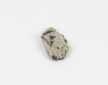
Geological specimen - Olivine Crystals, Unknown
Olivine is mostly found on the Earth's surface in igneous rocks that are dark-coloured. It is common at divergent plate boundaries and at warm spots, such as volcanic areas. It crystalises and forms during the cooling of magma. Olivine is used in refractory sand, bricks, and gemstones. Olivine has been found on a number of meteorites, which might have originated from large asteroids or the mantle of a now-destroyed planet. This olivine crystal is thought to originate from Mount Noorat, with speculation that it could have originated from Mount Shadwell. Mount Noorat is a dormant volcano cone located in the Newer Volcanics Province of Victoria. Mount Noorat belongs to the Kirrae Wuurong people, who used the Mount as a place for meetings and gatherings prior to European settlement. Contact was first made between European settlers and the Indigenous people in 1841. The Mount has mostly been used for cattle and sheep grazing. Mount Shadwell is a well-known source of olivine and is the highest of a gathering of volcanic cones. The New Volcanic Province is located in South East Australia and covers 15000 square kilometres. It contains 400 explosive vents and small shield volcanoes. The last eruption is thought to have occurred 5000 years ago at Mount Gambier and Mount Schank. This olivine crystal has been identified as a volcanic bomb, which is a molten rock which was pushed out and ejected into the air when a volcano reupts. A rock needs to be larger than 65 mm in diameter to be classified as a volcanic bomb. This olivine volcanic bomb and its locality is historically and socially significant. The olivine was found in the Newer Volcanic Province, an area which contains over 400 dormant volcanoes. This olivine is one part of a volcanic bomb, which would have ejected when magma erupted out of a volcano. This specimen is part of a larger collection of geological and mineral specimens collected from around Australia (and some parts of the world) and donated to the Burke Museum between 1868-1880. A large percentage of these specimens were collected in Victoria as part of the Geological Survey of Victoria that begun in 1852 (in response to the Gold Rush) to study and map the geology of Victoria. Collecting geological specimens was an important part of mapping and understanding the scientific makeup of the earth. Many of these specimens were sent to research and collecting organisations across Australia, including the Burke Museum, to educate and encourage further study.A solid iron-magnesium silicate mineral with shades of green and brownburke museum, beechworth, geological, geological specimen, olivine, igneous rock, volcanic, gemstones, volcanic bomb, meteorites, asteroids, plantes, mount noorat, mount shadwell, indigenous, kirrae wuurong people, newer volcanics province, victoria, european settlement, eruption -
 Ballarat Heritage Services
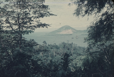
Slide, Dorothy Wickham, Matupi, Rabaul, Papua New Guinea, 1958
This photograph was taken before this volcano erupted and obliterated the Township of Rabaul, New Britain. On October 7, 2006, Rabaul Volcano on the northeastern tip of New Britain produced a large-scale eruption. According to ReliefWeb, the eruption shook windows and rained heavy ash and small stones on the city of Rabaul as authorities declared a state of emergency. See https://earthobservatory.nasa.gov/images/17486/eruption-from-rabaul-volcanoScanned from a coloured slideView from this sidematupi, rabaul, papua new guinea, crater, volcano -
 Ballarat Heritage Services
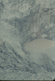
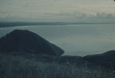
Slide, Dorothy Wickham, Matupi, Rabaul, Papua New Guinea, 1958
This photograph was taken around 1958 long before this volcano erupted and obliterated the Township of Rabaul, New Britain. On October 7, 2006, Rabaul Volcano on the northeastern tip of New Britain produced a large-scale eruption. According to ReliefWeb, the eruption shook windows and rained heavy ash and small stones on the city of Rabaul as authorities declared a state of emergency. See https://earthobservatory.nasa.gov/images/17486/eruption-from-rabaul-volcanoScanned from a coloured slideView from this sidematupi, rabaul, papua new guinea, volcano, island of new britain -
 Ballarat Heritage Services
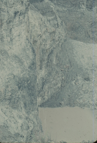
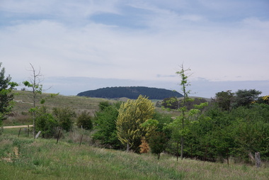
Photograph - Photograph - Colour, Mount Franklin from the Franklinford Cemetery, 2015, 25/10/2015
An extinct volcanic mountain known as Mount Franklin from the Franklinford Cemetery. . mount franklin, volcano, franklinford, franklinford cemetery, lalgambook -
 Federation University Art Collection
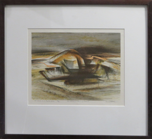
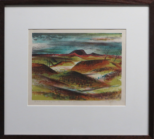
Work on paper - Artwork - Printmaking, Jack, Kenneth, 'Mt Eccles and Crater Lake, No.3 Volcanic Plains of Victoria ' by Kenneth Kack, 1961
Framed four plate lithograph depicitng Nt Eccles and Crater Lake on the Victorian cvolcanic plains. Donated through the Australian Gifts Programme by Katherine Littlewood.Edition 23/42kenneth jack, printmaking, mt eccles, volcano, lithograph -
 Bendigo Military Museum
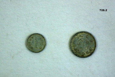
Currency - COINS, JAPANESE, est 1930's-1945
The coins were souveniered by VX65555 GNR R.J Lee MM. Refer 1734 for service history also 1814.3. .1) Coin, small, metal, silver colour. One side depicts a volcano with Japanese wording underneath. Other side has a small scroll arrangement with Japanese writing circled around. .2) Coin, medium sized, round metal, silverish colour. One side has centre circular arrangement, floral and Japanese writing. Other side has a 5 pointed arrangement in centre with Japanese writing around it.numismatics-coins, military history - japanese -
 Victorian Interpretive Projects Inc.
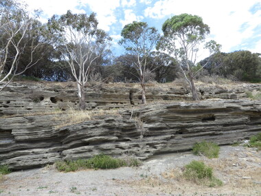
Photograph - Colour, Lisa Gervasoni, Tower Hill Volcanic Ash Layers, 2015, 25/12/2015
tower hill, volcano, volcanic ash, volcanic ash layers, geology, koroit -
 Victorian Interpretive Projects Inc.
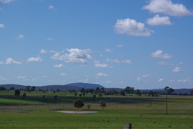
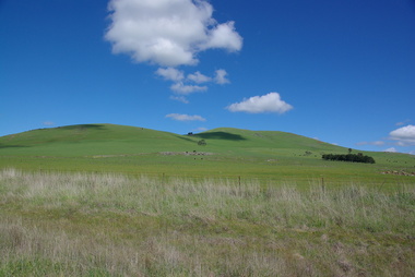
Photograph - Colour, Clare Kathleen Gervasoni, Smeaton Volcanic Landscapes, 2013, 22/09/2013
Smeaton Hill was the name of the property first settled by squatter Captain John Hepburn and Elizabeth Hepburn.Five landscape photographs of the seven volcanic hills around Smeaton.smeaton, kooroocheang, john hepburn, john hepburn, elizabeth hepburn, volcano, volcanic -
 Ballarat Heritage Services
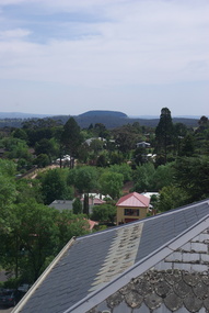
Photograph - Photograph - Colour, Mount Franklin from the Convent Gallery, Daylesford, 2015, 25/10/2015
The Convent Gallery was formerly Holy Cross Convent, and incorporates the Gold Commissioners house. An extinct volcanic mountain is seen in the distance. The slate roof of the former Holy Cross Convent in Daylesford is in the foreground. holy cross convent, presentation convent, convent gallery daylesford, slate roof, mount franklin, volcano, lalgambook -
 The Beechworth Burke Museum
Geological specimen - Chalcopyrite, Unknown
This specimen was recovered from Mica Schist, Canada. Chalcopyrite is a copper iron sulfide mineral with a chemical composition of CuFeS2. Its name derives from the Greek words for copper (chalco-) and brass (pyrite). It can be found in shades of yellow, green and grey, and, when exposed to acid, it can change to purple, blue, violet and yellow tones. Weathering can cause loss of its metallic luster and its brass-yellow colour. Chalcopyrite forms under various conditions, with the most significant deposits being hydrothermal in their origin. It is known globally as the most important ore of copper for thousands of years, and is thus considered a very important mineral formation. Given its golden appearance, it is often confused for the mineral gold, earning it the popular reputation as 'fool's gold' or 'yellow copper'. However, it can be straightforwardly distinguished from gold; the latter is soft, with higher specific gravity and a yellow streak, whereas chalcopyrite is brittle, easily scratched by a nail, and has a greenish grey streak. Copper was the first metal that was used by people. It was discovered by the Neolithic man about 9,000 years ago and it gradually replaced stone as it was easier to be shaped. In Australia, search for copper began after the European settlement, leading to the discovery of substantial deposits, like the one at the Olympic Dam in South Australia, which is regarded as one of the largest copper deposits in the world. Chalcopyrite has been used for copper since smelting processes began approximately five thousand years ago. Although by no means rare, this the specimen of this mineral can be used to reflect a wider history of industrial uses of copper for a significant portion of human history. This specimen is part of a larger collection of geological and mineral specimens collected from around Australia (and some parts of the world) and donated to the Burke Museum between 1868-1880. A large percentage of these specimens were collected in Victoria as part of the Geological Survey of Victoria that begun in 1852 (in response to the Gold Rush) to study and map the geology of Victoria. Collecting geological specimens was an important part of mapping and understanding the scientific makeup of the earth. Many of these specimens were sent to research and collecting organisations across Australia, including the Burke Museum, to educate and encourage further study.A solid hand-sized copper iron sulfide mineral of brass yellow, often with an iridescent tarnish, with greenish-black streak and submetallic luster. Chalcopyrite can be formed in several ways, including crystalizing from accessory minerals in igneous rocks, or from magma or within volcano sulfide deposits. Most commonly, chalcopyrite are found in hydrothermal conditions, where it forms in hydrothermal veins. As a member of the tetragonal crystal system, it often takes the shape of tetra-headed crystals, often with striations along the sides of the crystals. #18 Copper pyrites/(chalcopyrite) in/Laurentian Slate/(page 315 of inventory)/page missing from/descriptive catalogue/ Other label: 81 /fool's gold, chalcopyrite, mineral, rock, geology, geological, hydrothermal, neolithic, european settlement, olympic dam, south australia, stone, deposits, specific gravity, greenish grey streak, brittle, mineral gold, metallic luster, cufes2, greek words -
 City of Ballarat
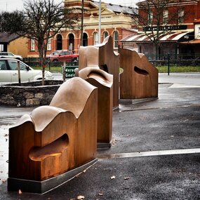
Artwork, other - Public Artwork, Cliff Burtt, Buninyong Bivium, 2016
Buninyong Bivium (2016) by Cliff Burtt engages with the geography and history of the Buninyong region in both pre and post settlement. The town of Buninyong is dominated by the profiles of Mt Helen and the extinct volcano Mt. Buninyong. Traditional land of the Wadawurrung people, today the area remains a significant site for the culture of indigenous people and their connection to the land. The profile of this sculpture is based on topographical mapping of the area, depicting sections of the landscape. The gaps between the elements of the work can be viewed as representations of the shafts sunk into the earth by the early gold miners and compound curves on the upper surfaces are mirroring the topography of the area, while cut-aways in the sides are suggestive of rock strata.The artwork is of aesthetic and social significance to the people of BallaratCorten steel sculpture made of five unique sculptural pieces secured to at concreate base at pavement levelbuninyong, cliff burtt, sculpture, public art, mining, ballarat -
 Ballarat Heritage Services
Digital photographs, L.J. Gervasoni, Tower Hill - international geological significance, c2015
tower hill, volcano, natural heritage, koroit, landscape, ash, geological, international significance -
 Ballarat Heritage Services
Photograph - Digital photographs, L.J. Gervasoni, Tower Hill - international geological significance - maar, c2015
Digital Photographs of tower hill near Koroit Victoria tower hill, volcano, natural heritage, koroit, landscape, ash, geological, international significance -
 Federation University Art Collection
Work on paper - Artwork - Printmaking, Jack, Kenneth, "Mt Porndon and the Stony Rises - No 6 Volcanic Plains of Victoria" by Kenneth Jack, 1962
Kenneth JACK AM MBE RWS, (5 October 1924 – 10 June 2006) Australian watercolour artist Kenneth Jack who specialised in painting the images of an almost forgotten outback life; old mine workings, abandoned ghost towns, decaying farm buildings. He became a professional painter at the age of 39 after giving up his job as senior instructor at the Caulfield Institute of Technology. In 1977 he was elected to The Royal Watercolour Society and in 1982 was awarded the MBE, and the Order of Australia (AM) followed in 1987. Framed three block lino print showing the volcanic plains of Victoria around Stony Rises. It is Number 6 in the Volcanic Plains of Victoria series. Donated through the Australian Gifts Programme by Katherine Littlewood.31/40artwork, artist, kenneth jack, printmaking, volcano, mt porndon, mount porndon, linocuts -
 Bendigo Military Museum
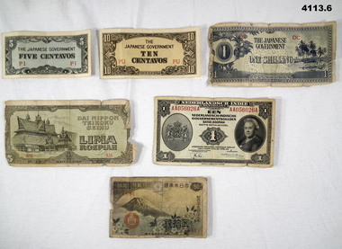
Currency - CURRENCY, ASSORTED, 5) 1943
Items .1) to .4) are Japanese invasion money.1) Note Japanese, blue colours, 5 Centavos with the letters “PI” in red. .2) Note Japanese, brown colours, ten centavos with the letters “PU” in red. .3) Note Japanese, blue colours, One Shilling with the letters “OC” in red. .4) Note Japanese, brown colours, 5 Lima Roepiah with the letters “SM” in red. .5) Note Dutch, One Roepiah, colours green, light blue and black, coat of Arms, portrait of Queen Wilhelmina, the letters “AA056026A” in red. .6) Note Japanese, colours red, light blue, white and black, Volcano and clouds in the background, the letters “644” in red on the front.currency, japanese, dutch, invasion -
 Federation University Historical Collection
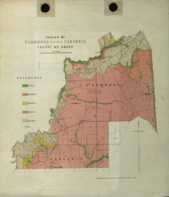
Plan - Map, Mines Department, Parish of Narmbool and part of Cargerie, County of Grant, 1892, 06/1992
This map shows the position of the homestead on the Narmbool Pre-emptive Right, volcanic craters, stock reserve, quarry and geological eras,Geological map showing Narmbool and part of Cargerie in the County of Grant in five colours, predominantly pink.narmbool, cargerie, narmbool pre-emptive right, williamson's creek, leigh river, green hill, collyer's hill, volcano, crater, krause, ferdinand krause -
 Ballarat Heritage Services
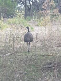
Photograph - Digital photographs, L.J. Gervasoni, Emus at Tower Hill Koroit, 2015
Digital images of emus on Tower Hill near Koroit, Victoriakoroit, moyne shire, volcano, maar, game reserve, tower hill, tower hill, emu, wildlife, native, bird, flightless -
 Ballarat Heritage Services
Photograph - Digital photographs, Clare Gervasoni, Emus at Tower Hill near Koroit, Victoria, 29/06/2020
Digital images of emus on Tower Hill near Koroit, Victoriakoroit, moyne shire, volcano, maar, game reserve, tower hill, tower hill, emu, wildlife, native, bird, flightless -
 Ballarat Heritage Services
Photograph - Digital photographs, Clare Gervasoni, Emus at Tower Hill Koroit, 2018
Digital images of emus on Tower Hill near Koroit, Victoriakoroit, moyne shire, volcano, maar, game reserve, tower hill, tower hill, emu, wildlife, native, bird, flightless -
 Ballarat Heritage Services
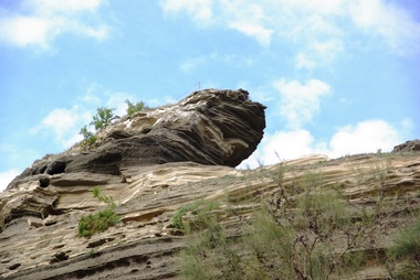
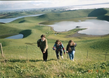
Photograph - Photograph - Colour, Kathleen Gervasoni, Red Rock, Alvie, 1989, 02/09/1989
Red Rock, Alvie, near Colac, is a complex of approximately 30 volcanic eruption points and is the Southern most of a chain of three volcanoes, the others being Warrion Hill and Alvie Hill. It is arguably the youngest eruption point in Victoria at around 8000 years, especially since the age of Mt Napier has been progressively pushed back. The highest point (on the Northern side) has many interesting features, including some awesome spatter ramparts. Driving around the rim to the south, you can also see layered tuff. There are some good views out to Lake Corangamite and the lava flows (probably from Warrion Hill) can be seen where they have entered the lake. Most of Red Rock is in private land, with two lookout points with some interpretive information. The water depicted in this photograph is not evident in 2019. Type: Volcanic Complex Location: South of Alvie, Victoria Last Eruption: 8000 years ago Access: Mostly private land, but there is an access road and some interpretive signage Visited: Visited Colour photograph of sisters Clare Gervasoni (left), Ann Gervasoni (centre) and Lisa Gervasoni and Red Rock, Alvie clare gervasoni, lisa gervasoni, ann gervasoni, red rock alvie -
 Eltham District Historical Society Inc
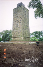
Photograph, Shire of Eltham War Memorial Tower, Memorial Park, Garden Hill, Kangaroo Ground Tower, 6 Aug 1996, 1996
On November 11th 1926 the Shire of Eltham War Memorial Tower at Kangaroo Ground was opened. It is regarded as one of Melbourne’s most outstanding lookout towers. It commands a magnificent 360 degree panorama from Kinglake across the Diamond Valley to Macedon and the You Yangs. It is built on a peak which was once a volcano, 237 metres above sea level. After World War one a memorial cairn was erected on the site, and in 1925 a committee of public-minded citizens began to plan for a tower. Many generous donations of material and money were forthcoming so that in 1926 the Governor General Lord Stonehaven was able to unveil the plaque before a crowd of 500 people. There was some concern in the 1960s when the Forests Commission wanted to build a firespotters cabin on the top. At first R.S.L. branches opposed the idea, but it was realised that this use could combine with its use as a tourist attraction, and would ensure its maintenance for the future, Today the Kangaroo Ground tower provides one of the best views around Melbourne and is a fitting memorial to those who died in two world wars. From: Historic items for Diamond Valley Community Radio September 1990 (EDHS collection) Roll of 35mm colour negative film, 7 stripsKodak Gold 100-5garden hill, kangaroo ground memorial, memorial park, shire of eltham war memorial tower, war memorial tower, war memorials