Showing 218 items matching woodlands
-
 Wodonga & District Historical Society Inc
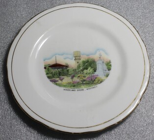
Memorabilia - Souvenir Plate Woodland Grove, Wodonga, Victoria, Royal Stafford China
A wide range of small china pieces carrying scenic views of holiday destinations or key locations were a popular kind of souvenir during much of the 20th century. Several different items have been produced to commemorate Wodonga and its landmarks over time. These items document key changes in Wodonga and its heritage. This plate depicts three key landmarks in Wodonga. THE SOLDIERS' MEMORIAL in Wodonga was unveiled on Tuesday 18th November 1924. It was designed by Messrs. Hosken & Co., of Hawthorn, Victoria. The monument is all of Australian workmanship. The pedestal is made of Harcourt granite, 9ft x 9ft at the base, and rising in seven courses to a height of 10ft 2in. The emblems (rising sun and wreath) are of bronze, and the lettering of the inscription and names of fallen soldiers are in raised lead letters. Originally the Memorial was completed with a full life size, 6ft in height, sculpture of an Australian soldier in Sicilian marble. The memorial bore the inscriptions: ERECTED BY THE RESIDENTS OF WODONGA AND DISTRICT IN MEMORY of the Men of this Town and District who fell in the Great War, 1914-1919, Also in grateful recognition of the men who served and returned. “Lest We Forget.” In 1982, due to frequent vandalism and high cost of materials to repair, the soldier statue was removed and later installed at the RSL Rooms. THE WATER TOWER is a major landmark of High Street, Wodonga. It began operation from 1924 until it ceased operation in 1952. It stood unused for a decade until the lower section was modified and put to use as “ The Tower’s Cobbler’s Inn” in 1962. In 1972 Wodonga City Council proposed to demolish the Tower. Their suggestion received an unfavorable response from the city’s citizens, so the Tower still stands today. THE BAND ROTUNDA was officially opened on Sunday 5th September 1920 at the naming of the triangular reserve at the corner of High and Hovell Streets as Woodland Grove. The Wodonga Band gave a public performance on this occasion. The tri-coloured ribbon, which stretched across the entrance to the Rotunda was cut by Mrs R.H Murphy, daughter of Mr. John Woodland, secretary of the Wodonga Shire Council for 35 years, after whom the area was named. The rotunda has since been moved to Martin Park, Wodonga. This bone china plate features an image of Woodland Grove. Wodonga, Victoria. The image incorporates landmarks in Woodland Grove, including the Soldiers' Memorial, the Rotunda and the Water Tower. There is a makers' mark imprinted on the underside of the plate."ROYAL STAFFORD/BONE CHINA/ MADE IN ENGLAND/ 423" . A crown is in the centre of the textmemorabilia, woodland grove, wodonga victoria -
 Wodonga & District Historical Society Inc
Souvenir - Souvenir Cup and Saucer Woodland Grove, Wodonga, Victoria, Royal Stafford China, c1940s
This item is from a collection donated by descendants of John Francis Turner of Wodonga. Mr. Turner was born on 6 June 1885. He completed all of his schooling at Scotts Boarding School in Albury, New South Wales. On leaving school, he was employed at Dalgety’s, Albury as an auctioneer. In 1924 John was promoted to Manager of the Wodonga Branch of Dalgety’s. On 15/03/1900 he married Beatrice Neal (born 7/12/1887 and died 7/2/1953) from Collingwood, Victoria. They had 4 daughters – Francis (Nancy), Heather, Jessie and Mary. In 1920, the family moved From Albury to Wodonga, purchasing their family home “Locherbie” at 169 High Street, Wodonga. "Locherbie" still stands in Wodonga in 2022. The collection contains items used by the Turner family during their life in Wodonga. A wide range of small china pieces carrying scenic views of holiday destinations or key locations were a popular kind of souvenir during much of the 20th century. Several different items have been produced to commemorate Wodonga and its landmarks over time. These items document key changes in Wodonga and its heritage. This plate depicts three key landmarks in Wodonga. THE SOLDIERS' MEMORIAL in Wodonga was unveiled on Tuesday 18th November 1924. It was designed by Messrs. Hosken & Co., of Hawthorn, Victoria. The monument is all of Australian workmanship. The pedestal is made of Harcourt granite, 9ft x 9ft at the base, and rising in seven courses to a height of 10ft 2in. The emblems (rising sun and wreath) are of bronze, and the lettering of the inscription and names of fallen soldiers are in raised lead letters. Originally the Memorial was completed with a full life size, 6ft in height, sculpture of an Australian soldier in Sicilian marble. The memorial bore the inscriptions: ERECTED BY THE RESIDENTS OF WODONGA AND DISTRICT IN MEMORY of the Men of this Town and District who fell in the Great War, 1914-1919, Also in grateful recognition of the men who served and returned. “Lest We Forget.” In 1982, due to frequent vandalism and high cost of materials to repair, the soldier statue was removed and later installed at the RSL Rooms. THE WATER TOWER is a major landmark of High Street, Wodonga. It began operation from January 1924 until it ceased operation in 1952. It stood unused for a decade until the lower section was modified and put to use as “ The Tower’s Cobbler’s Inn” in 1962. In 1972 Wodonga City Council proposed to demolish the Tower. Their suggestion received an unfavorable response from the city’s citizens, so the Tower still stands today. THE BAND ROTUNDA was officially opened on Sunday 5th September 1920 at the naming of the triangular reserve at the corner of High and Hovell Streets as Woodland Grove. The Wodonga Band gave a public performance on this occasion. The tri-coloured ribbon, which stretched across the entrance to the Rotunda was cut by Mrs R.H Murphy, daughter of Mr. John Woodland, secretary of the Wodonga Shire Council for 35 years, after whom the area was named. The rotunda has since been moved to Martin Park, Wodonga. This item comes from a collection used by a prominent citizen of Wodonga. It is also representative of a domestic item common in the 1940s and features significant landmarks used in many forms to represent the city of Wodonga.This bone china cup and saucer set features an image of Woodland Grove. Wodonga, Victoria. The image incorporates landmarks in Woodland Grove, including the Soldiers' Memorial, the Rotunda and the Water Tower. There is a makers' mark imprinted on the underside of the plate."ROYAL STAFFORD/BONE CHINA/ MADE IN ENGLAND/ 423" . A crown is in the centre of the textmemorabilia, woodland grove, wodonga victoria -
 Hume City Civic Collection
Photograph, early 1990s
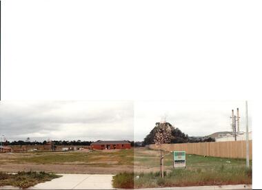
The series of 5 photographs feature different views of the Woodlands housing development which opened up land bounded by Gap and Anderson Roads, Cornish Street and Elizabeth Drive in the early 1990s. It was a large housing development built close to Sunbury township.A view of the northern boundary of the Woodlands housing development in Anderson Road. A paling fence divides the estate from the 'Malley' factory, now 'Storage King' which is on the corner of Cornish Street and Anderson Road. A 'For Sale' sign is in the foreground and a partly built house is in the middle distance.housing developments, anderson road, george evans collection -
 Tatura Irrigation & Wartime Camps Museum
Book - Family History, My Life, 2006
... woodlands ...To record the history of James Crawford family, past and present. Life at "Woodlands" contains many family photos and Toolamba historyWhite - Off white cover. Black writing, photo of author in colourmy life, crawford j, woodlands, tatura, crawford, harper, books, history, local -
 Melbourne Tram Museum
Photograph - Black and White photograph, 11/01/1925 12:00:00 AM
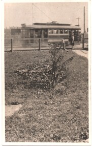
Black and white photograph of MMTB B class No. 23 taken from a front verandah on its first trip at the corner of High St and Woodlands Ave 11-1-25 on the return trip from Burke Road to Kew Depot. A young lady is standing by the front fence. The tram is well loaded with passengers and possibly the conductor standing in the rear section of the tram, revelling at speed.On rear in ink "MMTB No. 23 taken from a front verandah on its first trip at the corner of High St and Woodlands Ave 11-1-25 on the return trip from Burke Road to Kew Depot."trams, tramways, high st kew, b class, opening, tram 23 -
 Stawell Historical Society Inc
Memorabilia - Realia, c1950's
Square Butter Dish with English woodland scene, Trees and flowersstawell -
 Robin Boyd Foundation
Slide, Robin Boyd, 1950
Penleigh Boyd, Robin and Patricia Boyd's son, writes “Prior to 1950 Robin, like most other amateur or hobby photographers, took black and white printed photographs. The oldest slides date from 1950 when Robin and Patricia travelled to Europe on Robin’s Robert Haddon Travelling Scholarship.” In 1948 Robin Boyd was awarded ‘joint first place’ in the Robert Haddon competition for his design of Mildura art gallery. The scholarship helped fund their first overseas trip. Robin and Patricia were passengers on the Greek ship “Cyrenia” departing in May 1950, passing through the Suez Canal and landing in Genoa five weeks later. For six months, they travelled extensively throughout Europe (predominantly driving themselves) - France, Italy, United Kingdom, Sweden, Denmark, Germany, Austria, Switzerland and Spain.Colour slide in a mount. Woodland Cemetery, Stockholm, Sweden. (Architect: Gunnar Asplund.)Stockholm / Crematery / Crematorium / Encircled 43 (All Handwritten)haddon travelling scholarship, haddon, robin boyd, slide -
 Beechworth Honey Archive
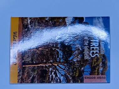
Publication, Common Trees of the Goldfields (Grant Pronk) Dept of Environment & Conservation - Bush Books, 2012
Soft cover slightly larger than A7, Photograph of Gimlet woodland on the front & back, white & black writing -
 Wodonga & District Historical Society Inc
Domestic object - Haeusler Collection Teapot
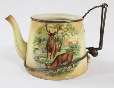
The Wodonga Historical Society Haeusler Collection provides invaluable insight into life in late nineteenth and early twentieth century north east Victoria. The collection comprises manuscripts, personal artefacts used by the Haeusler family on their farm in Wodonga, and a set of glass negatives which offer a unique visual snapshot of the domestic and social lives of the Haeusler family and local Wodonga community. The Haeusler family migrated from Prussia (Germany) to South Australia in the 1840s and 1850s, before purchasing 100 acres of Crown Land made available under the Victorian Lands Act 1862 (also known as ‘Duffy’s Land Act’) in 1866 in what is now Wodonga West. The Haeusler family were one of several German families to migrate from South Australia to Wodonga in the 1860s. This teapot is one of the many domestic objects in the Haeusler Collection that represent family and home life in early twentieth century Wodonga. The ingenious repair to the teapot's handle reflects the resourcefulness and thriftiness of the Haeusler family during the economic hardships of the 1930s Great Depression. The teapot was manufactured in England, likely dating from the early twentieth-century. This item has well documented provenance and a known owner. It forms part of a significant and representative historical collection which reflects the local history of Wodonga. It contributes to our understanding of domestic and family life in early twentieth century Wodonga, as well as providing interpretative capacity for themes including local history, social history, and women’s history. A glazed ceramic teapot with a printed design depicting two deer and a hunter in a woodland on one side, and two deer by a stream in a woodland on the other. The broken handle of the teapot has been replaced with wire. The teapot handle was repaired by Alfred Haeusler (b.1922, d.1997) and holds remarkable balance, perfectly retaining its function. Faded, circular makers mark on the base of teapot, illegible/"ENGLAND"teapot, teaware, tableware, ceramic, domestic, social history -
 Kew Historical Society Inc
Plan - Subdivision Plan, 6 Choice Residential Allotments: East Kew, 1932
Prue Sanderson, in her groundbreaking ‘City of Kew Urban Conservation Study : Volume 2 - Development History’ (1988), summarised the periods of urban development and subdivisions of land in Kew. The periods that she identified included 1845-1880, 1880-1893, 1893-1921, 1921-1933, 1933-1943, and Post-War Development. These periods were selected as they represented periods of rapid growth or decline in urban development. An obvious starting point for Sanderson’s groupings involved population growth and the associated economic cycles. These cycles also highlighted urban expansion onto land that was predominantly rural, although in other cases it represented the decline and breakup of large estates. A number of the plans in the Kew Historical Society’s collection can also be found in other collections, such as those of the State Library of Victoria and the Boroondara Library Service. A number are however unique to the collection.Subdivision plans are historically important documents used as evidence of the growth of suburbs in Australia. They frequently provide information about when the land was sold on which a built structure was subsequently constructed as well as evidence relating to surveyors and real estate and financial agents. The numerous subdivision plans in the Kew Historical Society's collection represent working documents, ranging from the initial sketches made in planning a subdivision to printed plans on which auctioneers or agents listed the prices for which individual lots were sold. In a number of cases, the reverse of a subdivision plan in the collection includes a photograph of a house that was also for sale by the agent. These photographs provide significant heritage information relating house design and decoration, fencing and household gardens.The mansion Woodlands in Harp Road, East Kew suffered the death of a thousand cuts. In its case, the cuts were subdivisions. Previous subdivisions of the mansion and its grounds were given titles such as ‘The Eastlawn Estate’ (MAP.0055), whereas at the end, the subdivision called it as it was, naming itself the ‘final section of the Woodlands Estate’ when it was put up for auction in 1932. The emphasis in the promotion of the subdivision was that it provided purchasers with splendid opportunities ‘to build modern homes in select, well established modern surroundings’. As with other subdivisions in the interwar period, transport links were emphasised. The six residential lots cut Woodlands off from Harp Road. When the vendor, Louisa Rachel Preston Hill, was to die at Woodlands in 1937 aged 86 her address was given as Normanby Road.subdivision plans - kew, woodlands estate -
 Emerald Museum & Nobelius Heritage Park
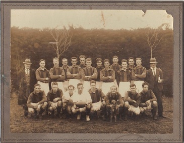
B/W Photograph, Freddy Woermer, 1931 Emerald Football Club Premiers, 1931
Emerald Football Club won the district Premiership in 1931, and had this photograph taken by Ferdinand ("Freddy") Woermer, whose stamp is on the reverse of the mounting. Woermer lived in a humpy on the Monbulk-Seville Road, Silvan (then Burleigh), and worked around the district as a professional photographer. He used a hollowed tree stump as a dark room for developing photographs.This photograph has double significance. On the one hand, it depicts the premiership team members in 1931. On the other, it is the work of F Woermer, a figure of some interest in the area.B/W photograph of the 1931 Emerald Football Club Premiers team, 22 people in all. Woodlands in background. Photo is glued to heavy cardboard.Rear: Stamp of manufacturers "F Woermer, Silvan Vic" and handwritten date "1931"emerald football club, woermer -
Tatura Irrigation & Wartime Camps Museum
Photograph - original, 1870's
Rebecca Shanks from Poyntz Pass County Armagh, Northern Ireland who married Andrew Crawford in 1873.Original sepia portrait of lady wearing a high necked top with white collar. Cameo at neckline and locket and chain around neck.Photograph is on cardboard backing board.On back of portrait - Mrs Rebecca Crawford, Woodlands. On front: Eden Photo Studios Paris Panel Melbourne and Sydneyrebecca shanks, andrew crawford, rebecca crawford -
Whitehorse Historical Society Inc.
Article, The Australian Garden Lover, 1937
Three pages from the Australian Garden Lover. Advertisements for 'Woodlands' Iris Garden, Blackburn and L. Challenor's Horticultural Service, Vermont, also H.D. Purcell Gladioli bulbs, Blackburn.Three pages from the Australian Garden Lover. Advertisements for 'Woodlands' Iris Garden, Blackburn and L. Challenor's Horticultural Service, Vermont, also H.D. Purcell Gladioli bulbs, Blackburn.Three pages from the Australian Garden Lover. Advertisements for 'Woodlands' Iris Garden, Blackburn and L. Challenor's Horticultural Service, Vermont, also H.D. Purcell Gladioli bulbs, Blackburn.horticulture, challenor's horticultural service, vermont, woodlands iris garden, blackburn, purcell, h.d. -
 Sunbury & District Heritage Association Inc
Photograph, Bulla Primary School, Gundiwindi School camp, 14th - 18th August 1989
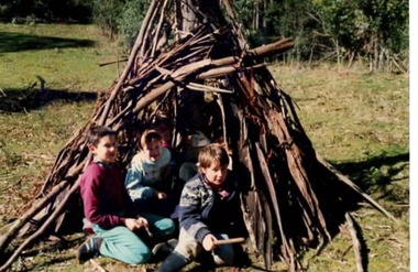
The photograph was taken in 1989 when the children in grades 4 an 5 attended a school camp at Gundiwindi, which is in the Yarra Valley on the border of Wandin and Nth. Silvan. At the camp the children were acquainted with the skills used by the local indigenous people. The children the photograph attempted to construct a bark shelter along the lines of those build by the local indigenous people. While the children from Bulla Primary School attended the camp at Gundiwindi they were introduced to skills used by local indigenous people.A coloured non- digital photograph of three children sitting at the entrance of a primitive bark shelter. The immediate surrounding area has been cleared but native woodland is growing beyond the fence line. school camps, gundiwindi, bulla primary school, indigenous culture -
 Eltham District Historical Society Inc
Photograph, Briar Hill
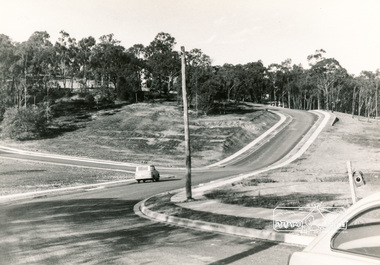
View of Squires land which was subdivided for housing - two parts Woodland Crest higher part off Woodland Grove and Calrossi Avenue, Briar Hill showing new roads with curb and channelling and footpaths. No date.Black and white photograph printed with white bordersVerso: COO2briar hill, real estate, woodland grove, squires, roads -
 Eltham District Historical Society Inc
Photograph, Woodland Crest, Briar Hill
View of Squires land which was subdivided for housing - two parts Woodland Crest higher part off Woodland Grove and Calrossi Avenue, Briar Hill showing new roads with curb and channelling and footpaths. No date.Black and white photograph printed with white bordersVerso: COO2briar hill, real estate, woodland grove, squires, roads -
 Eltham District Historical Society Inc
Photograph, Sherbourne Rise, Briar Hill
View of Squires land which was subdivided for housing - two parts Woodland Crest higher part off Woodland Grove and Calrossi Avenue, Briar Hill showing new roads with curb and channelling and footpaths. No date.Black and white photograph printed with white bordersVerso: COO2briar hill, real estate, woodland grove, squires, roads -
 Eltham District Historical Society Inc
Photograph, Briar Hill
View of Squires land which was subdivided for housing - two parts Woodland Crest higher part off Woodland Grove and Calrossi Avenue, Briar Hill showing new roads with curb and channelling and footpaths. No date.Black and white photograph printed with white bordersVerso: COO2briar hill, real estate, woodland grove, squires, roads -
Moorabbin Air Museum
Booklet (Item) - Digiprox Ground Proximity System, Litton Aero Products Division Digiprox Ground Proximity Warning System
Litton Aero Products, Woodland Hills, California -
Moorabbin Air Museum
Manual (Item) - Litton Aero Products battery units, Component Maintenance Manual with Illustrated Part List Battery Unit
Litton Aero Products, Woodland Hills, Cailfornia -
Moorabbin Air Museum
Manual (Item) - Litton Aero Products battery units, Overhaul Manual Battery Unit 510018
Litton Aero Products, Woodland Hills, California -
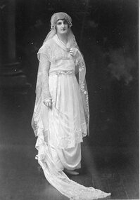 Stawell Historical Society Inc
Photograph, Mrs Alice Laidlaw nee McCulloch as a Bride --- Studio Portrait
Portrait Alice Laidlaw (nee McCulloch) as a Bride from Woodlandsstawell -
 Queen Victoria Women's Centre
Newspaper clipping, John Donegan, The reason Y - a new focus for the new women, 6 May 2006
Newspaper clipping from The Age. Unknown page. About the YWCA Victoria new direction. Colour photograph of fourwomen and a baby. 'The new face of the YWCA (from left) Kate Dunn, Erin Dolan, Brodie Woodland with baby Isaac, and Kitty Billings.charitable organisations, committees of management, women professionals -
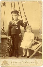 Stawell Historical Society Inc
Photograph, The Earl of Hopetoun's children 1895 -- Studio Portrait
Portrait - The Earl of Hopetoun's Family 1895. The youngest child was probably born at Woodlands Crowlandsstawell -
 Kew Historical Society Inc
Plan - Subdivision Plan, Jas R Mathers Son & McMillan, Eastlawn Estate : East Kew Auction Sale, 1914
The Kew Historical Society's map collection includes a substantial number of real estate subdivision plans, mainly of Kew but also of surrounding suburbs in Melbourne. Most of the subdivision plans date from the 1920s and 1930s when the districts old homes and local farmland were being split up to accommodate residential growth in the postwar period. These early plans were assembled by a local firm, Jas R Mather & McMillan, which had an office in Cotham Road. Many of the plans, and sometimes photos, were annotated by the agents.Subdivision plans are historically important documents used as evidence for the growth of suburbs in Australia. They frequently provide information about when the land was sold as well as evidence relating to surveyors and real estate and financial agents. The numerous subdivision plans in the Kew Historical Society's collection represent working documents, ranging from the initial sketches made in planning a subdivision to printed plans on which auctioneers or agents listed the prices for which individual lots were sold. In a number of cases, the reverse of a subdivision plan in the collection includes a photograph of a house that was also for sale by the agent. These photographs provide significant heritage information relating house design and decoration, fencing and household gardens.The photograph may also be aesthetically significant depending on the importance of the photographic atelier.The ‘Eastlawn Estate’ was surveyed and ready for auction in March 1914, three months before the outbreak of World War I. Sixty-six allotments, created on the ‘order of Mr & Miss Preston’ surrounded the mansion of Woodlands in Harp Road. Woodlands formed part of the Estate, being advertised as lot 1. The allotments faced High, Station and Wright Streets, Harp and Normanby Roads, and Woodlands Avenue. Pru Sanderson in the Kew Conservation Study (Vol.2, 1988) wrote that the Eastlawn Estate ‘covered the western half of the failed Harp of Erin Estate’. Contemporary advertisements promoted the Eastlawn Estate as: ‘There will be no more convenient district nor pleasant Suburb than East Kew for the busy business man. When the Electric Tram is laid, he will be able to journey quickly and pleasantly direct from Collins Street to his home in the Eastlawn Estate in about 20 minutes’. The actual plans of subdivision were included in advertisements in The Argus and in the local newspapers."C" top left. Various annotations.subdivision plans - kew, station street, normanby road, high street, woodlands avenue, harp road, woodlands - kew -
 Kew Historical Society Inc
Plan - Subdivision Plan, Eastlawn Estate, 1914
Subdivision plans are historically important documents used as evidence of the growth of suburbs in Australia. They frequently provide information about when the land was sold on which a built structure was subsequently constructed as well as evidence relating to surveyors and real estate and financial agents. The numerous subdivision plans in the Kew Historical Society's collection represent working documents, ranging from the initial sketches made in planning a subdivision to printed plans on which auctioneers or agents listed the prices for which individual lots were sold. In a number of cases, the reverse of a subdivision plan in the collection includes a photograph of a house that was also for sale by the agent. These photographs provide significant heritage information relating house design and decoration, fencing and household gardens.The ‘Eastlawn Estate’ was surveyed and ready for auction in March 1914, three months before the outbreak of World War I. Sixty-six allotments, created on the ‘order of Mr & Miss Preston’ surrounded the mansion of Woodlands in Harp Road. Woodlands formed part of the Estate, being advertised as lot 1. The allotments faced High, Station and Wright Streets, Harp and Normanby Roads, and Woodlands Avenue. Pru Sanderson in the Kew Conservation Study (Vol.2, 1988) wrote that the Eastlawn Estate ‘covered the western half of the failed Harp of Erin Estate’. Contemporary advertisements promoted the Eastlawn Estate as: ‘There will be no more convenient district nor pleasant Suburb than East Kew for the busy business man. When the Electric Tram is laid, he will be able to journey quickly and pleasantly direct from Collins Street to his home in the Eastlawn Estate in about 20 minutes’. The actual plans of subdivision were included in advertisements in The Argus and in the local newspapers.subdivision plans - east kew, eastlawn estate -
Tatura Irrigation & Wartime Camps Museum
Book, My Life, 2006
Written to record the history of James Crawford family, past and present. Life at "Woodlands" contains many family photos and Toolamba historyWhite/off white cover. Black writing. Photo of author in colour on front cover.my life, crawford james, tatura, books, history, local -
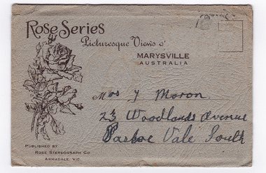 Marysville & District Historical Society
Photograph (item) - Black and white photographs, Rose Stereograph Company, Rose Series Picturesque Views of Marysville Australia, 1913-1967
A series of photographs produced by the Rose Stereograph Company in Victoria, Australia as a souvenir of Marysville.Souvenir envelope containing 12 black and white photographs of natural attractions in Marysville and surrounding area. Published by Rose Stereograph Co, Armadale, Victoria.Rose Series/ Picturesque Views of/ MARYSVILLE/ AUSTRALIA PUBLISHED BY/ ROSE STEREOGRAPH CO/ ARMADALE, VIC. Mrs. J Moron/ 23 Woodlands Avenue/ Pascoe Vale South The date stamp is illegible.the taggerty river marysville vic (image 1), panorama from mt gordon marysville vic (image 2), cora lynn falls marysville vic (image 3), cumberland-cora lynn trip marysville vic at the meeting of the waters (image 4), michael dene marysville vic (image 5), nichols lookout marysville vic (image 6), the stevenson river marysville vic (image 7), cathederal mount from mt gordon marysville vic (image 8), stevenson falls marysville vic (image 9), mountain ash tallest known hardwood tree in world (301ft 6in) cumberland marysville vic (image 10, the main street marysville vic (image 11), talbot drive vic no 12 taggerty river (image 12), rose stereograph company, souvenir, marysville, victoria -
 Hume City Civic Collection
Photograph, September 1994
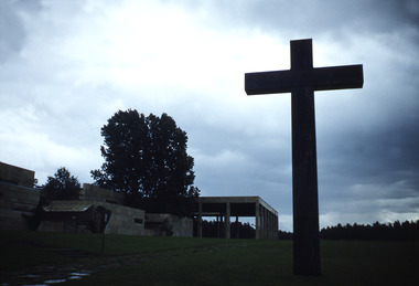
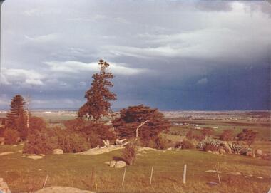
Woodlands Park complex which includes 'Cumberland' and 'Dundonald' ruins and the Gellibrand Hill Quarries was acquired by the Victorian State Government in 1978 and is managed by Parks Victoria.A view taken from Gellibrand Hill looking east towards the developing suburb of Greenvale. There are small rocky outcrops in the foreground and a clump of conifers and cypress trees in the middle. The sky is very overcast and a range of mountains can be seen across the skyline. Coloured photograph with rounded corners and matt finish.woodlands park, gellibrand hill, greene, william pomeroy, anne, george evans collection -
 Hume City Civic Collection
Photograph, September 1994
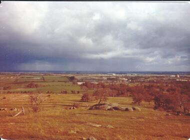
Woodlands Park complex which includes 'Cumberland' and 'Dundonald' ruins and the Gellibrand Hill Quarries was acquired by the Victorian State Government in 1978 and is managed by Parks Victoria.A view looking west towards the outer limits of the Tullamarine Airport taken from Gellibrand Hill. There is a small rocky outcrop in the middle of the photograph and trees are on the RHS of the image. Coloured photograph with rounded corners and matt finish.woodlands park, gellibrand hill, greene, william pomeroy, anne, george evans collection