Showing 78 items matching plenty gorge
-
 Greensborough Historical Society
Photograph - Digital Image, Blue Lake: Views of lake, 19/06/2015
... plenty gorge park...Blue Lake is in Yellow Gum Park in the Plenty Gorge, north... Lake is in Yellow Gum Park in the Plenty Gorge, north ...Blue Lake is in Yellow Gum Park in the Plenty Gorge, north of Greensborough. These photos show views of the lake.Digital copy of colour photographsyellow gum park, blue lake, plenty gorge park -
 Greensborough Historical Society
Photograph - Digital image, Marilyn Smith, Blue Lake: More views of the lake, 19/06/2015
... plenty gorge park...Blue Lake is in Yellow Gum Park in the Plenty Gorge, north... photographs Blue Lake is in Yellow Gum Park in the Plenty Gorge, north ...Blue Lake is in Yellow Gum Park in the Plenty Gorge, north of Greensborough. These photos show views of the lake.Digital copy of colour photographsyellow gum park, blue lake, plenty gorge park -
 Greensborough Historical Society
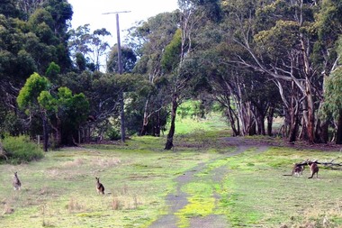
Photograph - Digital image, Marilyn Smith, Blue Lake: Kangaroos at Yellow Gum Park, 19/06/2015
... plenty gorge park...Blue Lake is in Yellow Gum Park in the Plenty Gorge, north... photographs Blue Lake is in Yellow Gum Park in the Plenty Gorge, north ...Blue Lake is in Yellow Gum Park in the Plenty Gorge, north of Greensborough. These photos show kangaroos in the Park.Digital copy of colour photographsyellow gum park, blue lake, plenty gorge park -
 Greensborough Historical Society
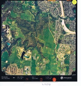
Aerial photograph, Qascophoto, Greensborough, 03/11/1986
... plenty gorge park...Aerial survey of Plenty Gorge Park area, including... by Qascophoto Aerial survey of Plenty Gorge Park area, including ...Aerial survey of Plenty Gorge Park area, including Greensborough by-pass construction and Metropolitan Ring Road reservation.An historical view of developing GreensboroughColour aerial photograph QAS 2504c run 5 3/11/86 1:15,500 by Qascophotoplenty gorge park, greensborough bypass, metropolitan ring road -
 Greensborough Historical Society
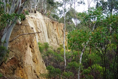
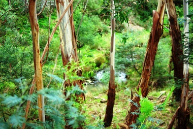
Photograph - Digital image, Marilyn Smith, Blue Lake: Vegetation, 19/06/2015
... plenty gorge park...Blue Lake is in Yellow Gum Park in the Plenty Gorge, north... is in Yellow Gum Park in the Plenty Gorge, north of Greensborough ...Blue Lake is in Yellow Gum Park in the Plenty Gorge, north of Greensborough. These photos show the variety of vegetation in the park.Digital copy of colour photographsyellow gum park, blue lake, plenty gorge park -
 Greensborough Historical Society
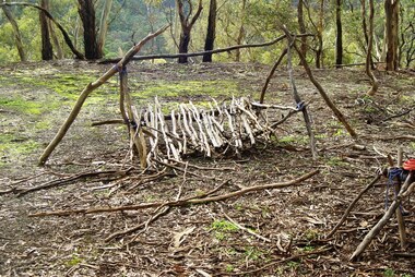
Photograph - Digital image, Marilyn Smith, Blue Lake: Makeshift camp-site, 19/06/2015
... plenty gorge park...Blue Lake is in Yellow Gum Park in the Plenty Gorge, north... Blue Lake is in Yellow Gum Park in the Plenty Gorge, north ...Blue Lake is in Yellow Gum Park in the Plenty Gorge, north of Greensborough. These photos show a makeshift camp site in the park.Digital copy of colour photographsyellow gum park, blue lake, plenty gorge park -
 Greensborough Historical Society
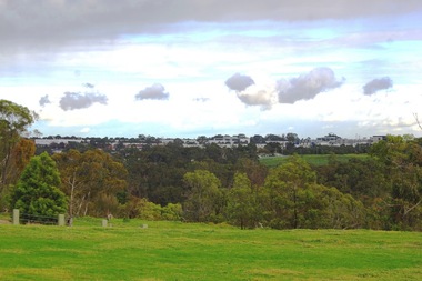
Photograph - Digital image, Marilyn Smith, Blue Lake: Greensborough from Yellow Gum Park, 19/06/2015
... plenty gorge park...Blue Lake is in Yellow Gum Park in the Plenty Gorge, north... park blue lake plenty gorge park Marilyn Smith ...Blue Lake is in Yellow Gum Park in the Plenty Gorge, north of Greensborough. This photo was taken from Yellow Gum Park and shows Greensborough in the distance.Digital copy of colour photographsyellow gum park, blue lake, plenty gorge park -
 Greensborough Historical Society
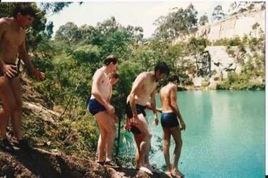
Photograph - Photograph - Digital Image, Swimming at Blue Lake
... plenty gorge park... of the Plenty Gorge Metropolitan Park...., a section of the Plenty Gorge Metropolitan Park. blue lake yellow ...Undated photographs of young men swimming at Blue Lake. Blue Lake is located in Yellow Gum Park, a section of the Plenty Gorge Metropolitan Park.3 digital photographsblue lake, yellow gum park, plenty gorge park, plenty river -
 Greensborough Historical Society
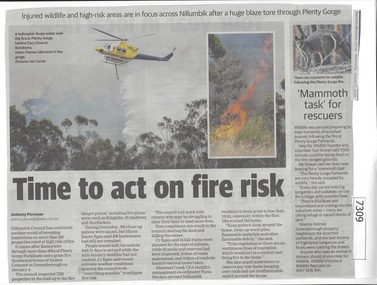
Newspaper Clipping, Diamond valley Leader, Time to act on fire risk, 15/01/2020
... plenty gorge park.... This follows a grass fire in Greensborough and a bushfire at Plenty... a grass fire in Greensborough and a bushfire at Plenty Gorge ...Nillumbik Council has conducted another round of sweeping inspections on more than 200 properties rated at high risk of fire. This follows a grass fire in Greensborough and a bushfire at Plenty Gorge Parklands.News article 1 page, black text.nillumbik council, high fire risk, symon crescent greensborough, plenty gorge park -
 Greensborough Historical Society
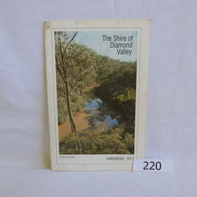
Book, Shire of Diamond Valley, The Shire of Diamond Valley Handbook 1977, 1977_
... "Plenty Gorge".... cover photograph "Plenty Gorge". The Shire of Diamond Valley ...The Shire of Diamond Valley was a Local Government Area located about 20 kilometres northeast of Melbourne. The shire covered an area of 74.38 square kilometres and existed from 1964 until 1994.Annual guide to services in Shire of Diamond Valley18pages, illus (some colour), maps. Front cover photograph "Plenty Gorge".shire of diamond valley, greensborough, handbooks -
 Greensborough Historical Society
Book, Isabel Ellender, The Plenty Valley Corridor: the archaeological survey of Aboriginal sites / by Isabel Ellender 1991, 1991_
... plenty gorge metropolitan park... (Melbourne Water), in particular the Plenty Gorge Metropolitan Park...), in particular the Plenty Gorge Metropolitan Park. The area studied ...This archaeological survey of the Plenty Valley was conducted by Isabel Ellender in 1991 for the Board of Works (Melbourne Water), in particular the Plenty Gorge Metropolitan Park. The area studied is north of Greensborough to Whittlesea. A number of Aboriginal sites were identified and recommendations made for the future.67 p., illus., maps. Plastic spiral binding.plenty river, aboriginal heritage sites, plenty gorge metropolitan park -
 Eltham District Historical Society Inc
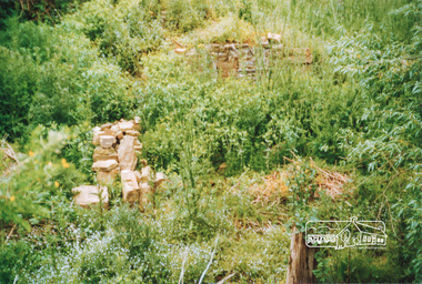
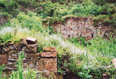
Photograph, Ruins of Coulstocks Mill, Janefield, South Morang
... plenty gorge... plenty gorge bundoora ...Mill Park Farm at Janefield on the Plenty River was established around 1840 by George Coulstock where he grew wheat. His flour mill was one of the first in Victoria, under construction as early as 1841. After bushfires and Coulstock's early death in 1842, the farm and its mill were taken over by local landowners Henry Miller and John Brock. Peter Hurlestone took charge of the mill. With water diverted from the Plenty River to fill the newly built Yan Yean Reservoir which opened in 1857, the Hurlestone family quit and that was the demise of the mill.Four colour photographs showing the ruins of Coulstocks Flour Mill (Janefield Mill), Janefield. 1. Stone wall 2. Old mill 3. Stone remains of old mill 4. Tree near old mill sitemills, flour mills, coulstock, janefield, plenty river, ruins, stone walls, plenty gorge, bundoora -
 Eltham District Historical Society Inc
Photograph, Ruins of Coulstocks Mill, Janefield, South Morang
... plenty gorge... stone walls bundoora plenty gorge ...Mill Park Farm at Janefield on the Plenty River was established around 1840 by George Coulstock where he grew wheat. His flour mill was one of the first in Victoria, under construction as early as 1841. After bushfires and Coulstock's early death in 1842, the farm and its mill were taken over by local landowners Henry Miller and John Brock. Peter Hurlestone took charge of the mill. With water diverted from the Plenty River to fill the newly built Yan Yean Reservoir which opened in 1857, the Hurlestone family quit and that was the demise of the mill.Five colour photographs of ruins of Coulstocks Mill, Janefield (Mill Park - Bundoora)mills, flour mills, coulstock, janefield, plenty river, ruins, stone walls, bundoora, plenty gorge -
 Greensborough Historical Society
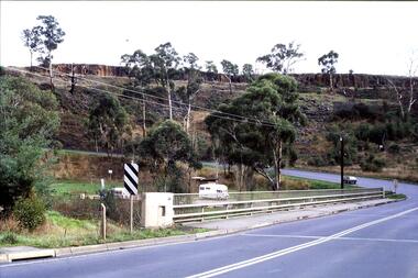
Slide - Photograph, John Ramsdale, Middle Gorge Park on Gorge Road: Slide 41, 1990s
... plenty gorge metropolitan park... gorge park kurrak road yarrambat plenty gorge metropolitan park ...Photograph shows a bridge with van, road is on steep hill. This is the carpark at Middle Gorge Park on Kurrak Road Yarrambat.Part of the John Ramsdale collection of slides and audio visual material.Colour photograph scanned from slide.No caption. Printed maker's mark on slide "Kodak Kodachrome Slide"middle gorge park, kurrak road yarrambat, plenty gorge metropolitan park -
 Eltham District Historical Society Inc
Photograph - Digital Photograph, Marguerite Marshall, Stuchbery Farm dairy, 14 March 2008
... Plenty Gorge Park... Stuchbery dairy Stuchbery Farm farm buildings Yarrambat Plenty Gorge ...Stuchbery Farm was situated on the Plenty River bounded by Smugglers Gully to the north and La trobe Road, Yarrambat, to the east. Alan and Ada Stutchbery moved to the valley in 1890, first living in a tent where four children were born. Alfred built a home and outbuildings around 1896. They planted an orchard, then a market garden and developed a dairy. Published: Nillumbik Now and Then / Marguerite Marshall 2008; photographs Alan King with Marguerite Marshall.; p179This collection of almost 130 photos about places and people within the Shire of Nillumbik, an urban and rural municipality in Melbourne's north, contributes to an understanding of the history of the Shire. Published in 2008 immediately prior to the Black Saturday bushfires of February 7, 2009, it documents sites that were impacted, and in some cases destroyed by the fires. It includes photographs taken especially for the publication, creating a unique time capsule representing the Shire in the early 21st century. It remains the most recent comprehenesive publication devoted to the Shire's history connecting local residents to the past. nillumbik now and then (marshall-king) collection, ada stuchbery, alan stuchbery, dairy, stuchbery farm, farm buildings, yarrambat, plenty gorge park -
 Greensborough Historical Society
Film - Video Cassette, John Ramsdale, Change in the Plenty corridor, 05/12/1990
... plenty gorge.... plenty river plenty gorge "Chapple E180 videocassette ...Video of a fieldwork for teachers, taken by John Ramsdale in 1990, investigating changes along the Plenty River.Part of the John Ramsdale collection of slides and audio visual material.VHS video tape, 2 copies."Chapple E180 videocassette" and "Change in the Plenty corridor unedited 5.12.90"plenty river, plenty gorge -
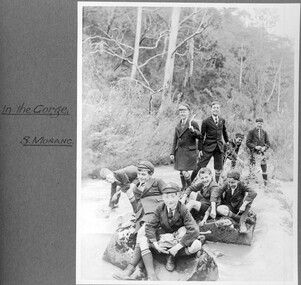 St Patrick's Old Collegians Association (SPOCA)
Photograph - Students, 1920s
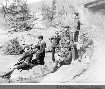
... c1928 Nine students in the Plenty River gorge at South... in the Plenty River gorge at South Morang. Photographed by Fr John ... -
 Greensborough Historical Society
Newsletter, Greenhills and North Greensborough Progress Association, Community News: official journal of the Greenhills and Nth. Greensborough Progress Association. 5th September, 1975, 05/09/1975
... the Council Chamber, The Plenty Gorge : can our region's major... of Greensborough, From the Council Chamber, The Plenty Gorge : can our ...This edition includes a report on the Progress Association's meeting, A park close to the heart of Greensborough, From the Council Chamber, The Plenty Gorge : can our region's major landscape resource survive?Newsletter, 4 p., illus.greenhills and north greensborough progress association, greenhills -
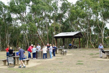 Greensborough Historical Society
Photograph - Digital image, Marilyn Smith, Blue Lake BBQ, February 2016, 27/02/2016
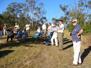
... in the Plenty Gorge. More photos of this event can be found at the GHS... in the Plenty Gorge. More photos of this event can be found at the GHS ...Group of Greensborough Historical Society members at the Blue Lake BBQ in February 2016. Blue Lake is in Yellow Gum Park in the Plenty Gorge. More photos of this event can be found at the GHS Resource Centre.Digital copy of colour photograph.greensborough historical society, plenty river, blue lake, yellow gum park -
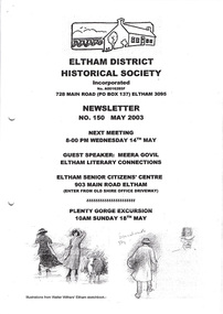 Eltham District Historical Society Inc
Newsletter, No. 150 May 2003
... : Eltham Literary Connections • May Meeting • Plenty Gorge... • Plenty Gorge Excursion • War memorials in Australia • Walter ...Contents: • Next meeting, guest speaker; Meera Govil: Eltham Literary Connections • May Meeting • Plenty Gorge Excursion • War memorials in Australia • Walter Withers in 1903 • Office Bearers 2003/2004 • Subscriptions 2003/2004 • Life Members • Other News The Shire of Eltham Historical Society was formed in October 1967. The first newsletter of the Society was issued May 1978 and has been published continuously ever since on a bi-monthly basis. With the cessation of the Shire of Eltham in late 1994, the Society's name was revised to Eltham District Historical Society and this name first appeared with issue No. 103, July 1995. The collection of the Society's newsletters provides a valuable resource on the history of the Society's activities, office bearers and committee members, guest speakers and subjects of historical interest pertinent to the former Shire of Eltham and the Eltham District.A4 photocopied newsletter distributed to membersnewsletter, eltham district historical society, shire of eltham historical society -
 Greensborough Historical Society
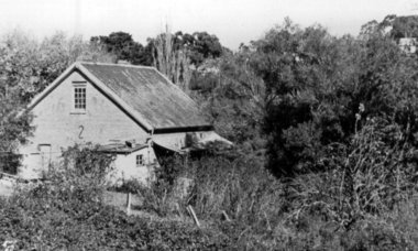
Photograph - Digital Image, Willis Vale site, 2014_
... in 1964 when a fire originating from North Plenty Gorge - Kurrak... a fire originating from North Plenty Gorge - Kurrak Road ...Photograph of the site of the 'Willis Vale' homestead, home of the Partington family. The derelict Willis Vale house was destroyed in 1964 when a fire originating from North Plenty Gorge - Kurrak Road - was lit by two teenage boys and made its way several kilometres down to Partington's Flat Greensborough.Digital copy of colour photograph."This house is where Willis Vale homestead was on Partingtons Flat"partington family, willis vale -
 Greensborough Historical Society
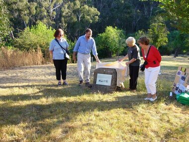
Photograph - Digital image, Unveiling Happy Hollow plaque, 24/10/2006
... Victoria in 1994 to form part of the Plenty Gorge Parklands... to form part of the Plenty Gorge Parklands. This plaque was laid ...Photograph of descendants of past owners of Happy Hollow unveiling the commemorative plaque. Includes descendants of Charles Partington, John McLaughlin and Robert Emmett Whatmough. The land was later owned by Mrs Betty Bell and was purchased by Parks Victoria in 1994 to form part of the Plenty Gorge Parklands. This plaque was laid by Plenty Historical Society. Digital copies of 3 colour photographs.happy hollow, plenty river, john mclaughlin, charles partington, robert emmett whatmough, parks victoria -
 St Patrick's Old Collegians Association (SPOCA)
Photograph - Students, 1920s
... 1928 Eight students at the Gorge on Plenty River... at the Gorge on Plenty River. Photographed by Fr John Forster SJ ... -
 Greensborough Historical Society
Photograph - Digital image, Happy Hollow plaque unveiling 1 and 2, 24/10/2006
... by Parks Victoria in 1994 to form part of the Plenty Gorge... Victoria in 1994 to form part of the Plenty Gorge Parklands ...Photograph of descendants of past owners of Happy Hollow preparing to unveil the commemorative plaque. Includes descendants of Charles Partington, John McLaughlin and Robert Emmett Whatmough. The land was later owned by Mrs Betty Bell and was purchased by Parks Victoria in 1994 to form part of the Plenty Gorge Parklands. This plaque was laid by Plenty Historical Society. Digital copy of colour photograph.happy hollow, robert emmett whatmough, charles partington, betty bell, parks victoria -
 Greensborough Historical Society
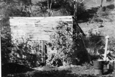
Photograph - Digital image, Outhouse, Willis Vale, 1920c
... in 1964 when a fire originating from North Plenty Gorge - Kurrak... originating from North Plenty Gorge - Kurrak Road - was lit by two ...This photograph shows one of the out buildings at 'Willis Vale', a property owned and farmed by the Partington family from the 1870s. The derelict Willis Vale house was destroyed in 1964 when a fire originating from North Plenty Gorge - Kurrak Road - was lit by two teenage boys and made its way several kilometres down to Partington's Flat Greensborough.The hoe of a pioneer Greensborough family.Digital copy of black and white photograph.willis vale, partington family -
 Greensborough Historical Society
Map, Melbourne and Metropolitan Board of Works. Survey Division, MMBW, Yarra 2500 / 12.24. Plenty and Blue Lake, 1977_10
... Lake in the Plenty Gorge.... and Blue Lake in the Plenty Gorge. mmbw melbourne and metropolitan ...Melbourne and Metropolitan Board of Works. Yarra 2500 [base map]. 12-24, Municipalities of Whittlesea 239 and Diamond Valley 257. Shows street names, easement sizes, lot numbers, lodged plan numbers, names of prominent features, contour values, creek or river names. Watsonia Railway Station and environs. Prominent streets: Memorial Drive. Includes Plenty River and Blue Lake in the Plenty Gorge.MMBW Map in 1:2500 [scale] series. Cream parchment with green tape reinforcing on edges and punched holes on left edge.mmbw, melbourne and metropolitan board of works, shire of diamond valley, plenty - maps, blue lake -
 Greensborough Historical Society
Photograph - Digital Image, Willis Vale, 1950c
... originating from North Plenty Gorge - Kurrak Road - was lit by two... was destroyed in 1964 when a fire originating from North Plenty Gorge ...House built by Edward Maygar, Robert Whatmough lived there mid 19th century and later sold to Partington family. It was located on the Plenty River at Partington's Flat Greensborough. The derelict Willis Vale house was destroyed in 1964 when a fire originating from North Plenty Gorge - Kurrak Road - was lit by two teenage boys and made its way several kilometres down to Partington's Flat Greensborough.Willis Vale was one of the earliest homes built in the area.Black and white digital photograph.willis vale, partington family -
 Greensborough Historical Society
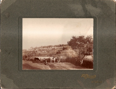
Photograph, Willis Vale 1906, taken from the hill, 1906_
... a fire originating from North Plenty Gorge - Kurrak Road - lit... a fire originating from North Plenty Gorge - Kurrak Road - lit ...'Willis Vale' home of the Partington family is shown in this photograph as well as the area now known as Partington's Flat. The area was owned and farmed by the Partington family from the 1870s. The derelict Willis Vale house was destroyed in 1964 when a fire originating from North Plenty Gorge - Kurrak Road - lit by two teenage boys - made its way several kilometres down to Partington's Flat Greensborough.Photograph shows an early view of Greensborough in 1906.Professional photograph in sepia mounted on dark green card. Shows Greensborough township in background with Willis Vale homestead in centre. On back: A.M.Partington Greensborough 1906.willis vale, partington family, greensborough, alan partington -
 Greensborough Historical Society
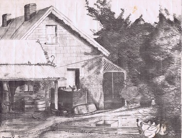
Drawing, Willis Vale by Sharyn Partington, 1983_
... a fire originating from North Plenty Gorge - Kurrak Road... a fire originating from North Plenty Gorge - Kurrak Road ...Drawn in 1983 by Sharyn Partington (age 15). Sharyn is the daughter of Trevor and granddaughter of Alan and Wyn Partington. The artwork would have been drawn from photos of the Partington home. The derelict Willis Vale house was vandalized in 1964 destroyed when a fire originating from North Plenty Gorge - Kurrak Road - was lit by two teenage boys and made its way several kilometres down to Partington's Flat Greensborough.An original artwork of the Partington home created by a descendant of the occupants.Pencil drawing on cream art paper. Depicts a view of Willis Vale. In black frame under glass.Signed "Sharyn P. 1983"partington, sharyn partington, willis vale, greensborough -
 Greensborough Historical Society
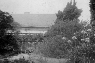
Photograph - Digital image, Willis Vale, 1939c
... originating from North Plenty Gorge - Kurrak Road - was lit by two... originating from North Plenty Gorge - Kurrak Road - was lit by two ...Willis Vale: House built by Edward Maygar, Robert Whatmough lived there mid 19th century and later sold to Partington family. It was located on the Plenty River at Partington's Flat Greensborough. The derelict Willis Vale house was destroyed in 1964 when a fire originating from North Plenty Gorge - Kurrak Road - was lit by two teenage boys and made its way several kilometres down to Partington's Flat Greensborough.Home of the Partington family.Digital copy of black and white photograph.willis vale, partington family, maygar family, whatmough